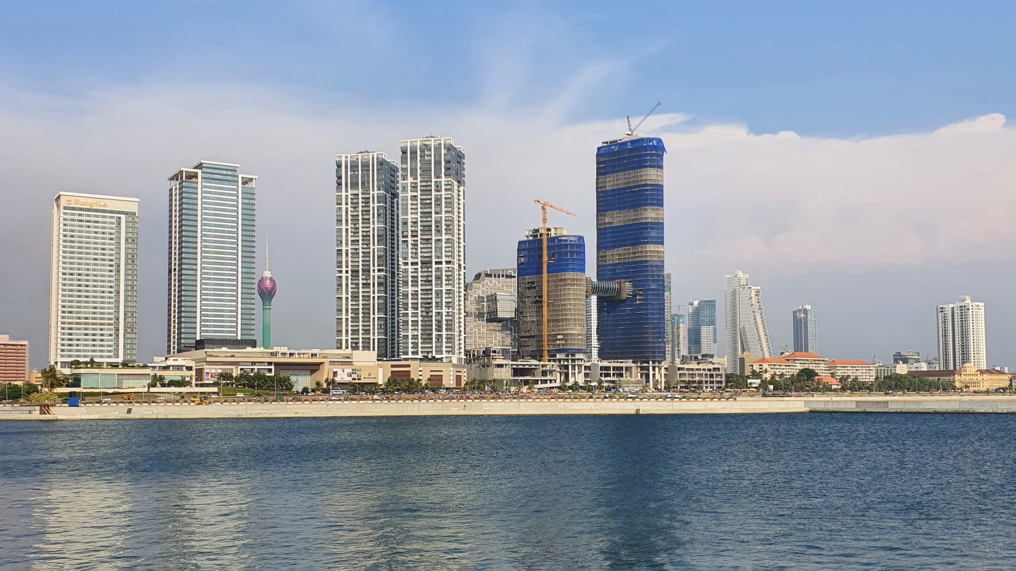
Colombo's waterfront skyline of tall towers seen across blue sea water

Colombo & the West, Sri Lanka

Colombo

The Colombo skyline seen from the Port City reclamation, January 2022. (XKillSwitchXxx / Wikimedia Commons · CC BY-SA 4.0)

Sri Lanka's largest city and its commercial capital, on the island's west coast beside a natural harbour that Arab, Portuguese, Dutch and British traders all used in turn. The colonial Fort district, the crowded bazaars of Pettah, Buddhist temples on Beira Lake and the seafront at Galle Face sit among new towers, while Parliament meets at Kotte inland.

Neighbourhoods

  • Fort
    • First-time visitors
    • Historic district
    • Close to public transport

    The old colonial and administrative core beside the harbour, with the Presidential Secretariat, the clock-tower lighthouse and the restored Dutch Hospital arcade. Security fencing kept much of it closed during the war years, and it has since reopened as a district of offices, hotels and restaurants. The main railway station and the bus stands are at its edge.

    Open in Maps
  • Pettah
    • Markets
    • Local life
    • Close to public transport

    The wholesale bazaar quarter immediately east of Fort, where each street specialises — textiles, hardware, fruit, electronics, spices. The red-and-white striped Jami Ul-Alfar mosque and the Dutch-era Wolvendaal Church stand among the stalls. Crowded, loud and best seen in the morning.

    Open in Maps
  • Kollupitiya
    • First-time visitors
    • Best for food
    • Shopping

    Colombo 3, running south from Galle Face along Galle Road, with much of the city's hotel stock, embassies, shopping malls and restaurants. It is the easiest base for a short stay, within walking distance of the seafront promenade.

    Open in Maps
  • Cinnamon Gardens
    • Quiet and residential
    • Museums
    • Parks

    Colombo 7, laid out on former cinnamon plantations and long the city's most prosperous address, with wide tree-lined streets and large colonial-era houses. The National Museum, Viharamahadevi Park, Independence Memorial Hall and several university faculties are here.

    Open in Maps
  • Slave Island
    • Historic district
    • Best for food

    Colombo 2, a peninsula in Beira Lake named for the people held there under Dutch rule, now a dense mixed quarter of Muslim and Malay families, small mosques, old shophouses and new high-rise development. Gangaramaya temple and the Seema Malaka pavilion are on its edge.

    Open in Maps
  • Bambalapitiya and Wellawatte
    • Best for food
    • Local life
    • Beaches

    Residential Colombo 4 and 6, strung along Galle Road and the coastal railway south of Kollupitiya. Wellawatte has a strong Tamil character and a run of South Indian restaurants and sari shops, and both have short strips of city beach beside the tracks.

    Open in Maps
  • Mount Lavinia
    • Beaches
    • Quiet and residential

    A seaside suburb south of the centre, built around a British governor's residence that is now a hotel on a headland. It has the closest proper beach to Colombo, a line of seafood restaurants along the sand and a station on the coastal line.

    Open in Maps

Things to do

Famous landmarks

  • Old Colombo Dutch Hospitallandmark

    A low colonnaded building of the Dutch period, held to be the oldest building in the Fort area and recorded as standing by 1681, restored in 2011 as a precinct of shops and restaurants around its courtyards.

    Open in Maps
  • Lotus Towerlandmark

    A tower of about 350 metres beside Beira Lake, shaped and lit as a lotus flower, with an observation deck looking over the city and the sea.

    Open in Maps
  • Colombo Lighthouselandmark

    The working lighthouse on Galle Buck in Fort, which replaced the older clock-tower light that still stands inland on Chatham Street.

    Open in Maps
  • Independence Memorial Halllandmark

    An open stone pavilion in Cinnamon Gardens modelled on the royal audience hall of the Kandyan kingdom, built to commemorate the independence of 1948 on the spot where the first parliament was opened, with a museum beneath it.

    Open in Maps
  • Galle Face Hotellandmark

    A colonial seafront hotel at the southern end of Galle Face Green, founded in 1864 and one of the oldest hotels east of Suez.

    Open in Maps

Temples, churches and mosques

  • Gangaramaya Templelandmark

    A crowded working Buddhist temple near Beira Lake whose halls are packed with donated statues, relics and curiosities, with a museum, a library and a monastic college on the premises, and which runs the Navam Perahera procession.

    Open in Maps
  • Seema Malakalandmark

    Three platforms of timber pavilions set in Beira Lake, rebuilt in 1976 to a design by the architect Geoffrey Bawa after the original sank, used for monastic ceremonies and linked to the shore by pontoon bridges.

    Open in Maps
  • Jami Ul-Alfar Mosquelandmark

    The red-and-white striped mosque on Second Cross Street in Pettah, begun in 1908 and finished in 1909, and said to have served sailors as a landmark on the approach to the harbour.

    Open in Maps
  • Wolvendaal Churchlandmark

    A Dutch Reformed church on a low hill above Pettah, begun in 1749 and dedicated in 1757, cruciform and massively walled, with Dutch tombstones set into its granite floor.

    Open in Maps
  • Kelaniya Raja Maha Viharalandmark

    A major Buddhist temple on the Kelani River north-east of the city, believed to have been visited by the Buddha, its image house painted by Solias Mendis.

    Open in Maps

Museums and galleries

  • Colombo National Museummuseum

    The island's largest museum, opened in 1877 in Cinnamon Gardens, holding the regalia of the Kandyan kings, Sinhalese bronzes and colonial-era collections.

    Open in Maps
  • Colombo Dutch Museummuseum

    The 17th-century house on Prince Street in Pettah that was the residence of the Dutch governor Thomas van Rhee, a museum of the Dutch period since 1982.

    Open in Maps
  • Gangaramaya Museummuseum

    The temple's own museum rooms, a dense and unusual collection of Buddhist images, gifts and curiosities gathered over a century.

    Open in Maps

Parks, lakes and the seafront

  • Galle Face Greenpark

    A long strip of lawn between Galle Road and the sea, laid out under British rule and now the place where Colombo gathers at dusk for kites, sea air and food carts.

    Open in Maps
  • Viharamahadevi Parkpark

    The oldest and largest park in Colombo, opposite the colonial-era town hall in Cinnamon Gardens, laid out by the British as Victoria Park and renamed in 1958, with flowering trees, a large Buddha statue and fountains.

    Open in Maps
  • Beira Lakepark

    The lake at the centre of the city, put to use through the Portuguese, Dutch and British periods and linked to a network of canals that carried goods inland, now ringed by a walkway.

    Open in Maps
  • Mount Lavinia Beachbeach

    The nearest sandy beach to the city, backed by seafood restaurants and the headland hotel, busy at weekends and with strong currents in the monsoon.

    Open in Maps

Markets and modern Colombo

  • Pettah marketmarket

    Street after street of wholesale and retail trade east of Fort, divided by trade, with the Manning Market produce trade and the old Federated Spice Market nearby.

    Open in Maps
  • Port City Colomboattraction

    A special economic zone under construction on 269 hectares of land reclaimed beside Galle Face Green, planned as a financial district with a marina and residential precincts, and with a promenade and beach along its seaward edge.

    Open in Maps
  • Colombo Fort railway stationtransit hub

    The hub of the island's rail network, from which the coastal line runs south and the main line climbs to Kandy and the hill country.

    Open in Maps
  • Nelum Pokuna Mahinda Rajapaksa Theatreattraction

    The city's main performing arts centre, its roof shaped as a lotus, used for concerts, dance and theatre.

    Open in Maps
  • R. Premadasa Stadiumattraction

    Sri Lanka's largest cricket ground, in Maligawatta, where the national team plays one-day and Twenty20 internationals under lights.

    Open in Maps

Short trips from the city

  • National Zoological Gardensattraction

    A large zoo at Dehiwala, south of the city, founded in 1936 and one of the oldest in Asia.

    Open in Maps
  • Sri Jayawardenepura Kotteattraction

    The legislative capital east of Colombo, seat of the medieval kingdom of Kotte and, since the capital was formally moved in 1982, of Parliament, which meets in a Geoffrey Bawa building set in a lake.

    Open in Maps

Seasonal events

  • Duruthu PeraheraJanuary, at the full moon

    A night procession of drummers, dancers and elephants at the Kelaniya Raja Maha Vihara north-east of the city, marking the Buddha's legendary visit.

  • Navam PeraheraFebruary, at the full moon

    Gangaramaya temple's procession past Beira Lake and through central Colombo, with elephants, whip-crackers and hundreds of monks.

  • Sinhala and Tamil New Yearmid-April

    The island's main holiday, when much of Colombo leaves for family homes in the villages and the city goes quiet for several days.

  • VesakMay, at the full moon

    The Buddhist festival of the Buddha's birth, enlightenment and death, when the city is hung with paper lanterns, illuminated pandals tell Jataka stories and dansal stalls hand out free food.

  • Colombo International Book FairSeptember, sometimes running into early October

    The country's largest book fair, held at the Bandaranaike Memorial International Conference Hall and one of the busiest public events in the city's calendar.

Eat and drink

Long-standing places and food districts in Colombo. Hours, ratings and directions come from your maps app, always current.

Colombo classics

  • Lamprais and Burgher cookingrestaurant

    The Dutch Burgher dish that Colombo made its own — rice cooked in stock, baked in a banana leaf with meat curry, frikkadel meatballs, aubergine and blachan shrimp paste. Old bakeries and hotel delis sell it by the parcel.

    Open in Maps
  • Crab and seafood in Fortrestaurant

    Sri Lankan lagoon crab, long exported rather than eaten at home, is the speciality of several restaurants in and around the Old Dutch Hospital.

    Open in Maps
  • Galle Face Hotelrestaurant

    The seafront hotel's terrace and dining rooms, known for colonial-era set pieces such as afternoon tea and curry lunches looking out at the Indian Ocean.

    Open in Maps

Food districts and markets

  • Galle Face Green food cartsmarket

    Evening vendors along the promenade selling isso wade (prawn fritters), cooked crab, grilled corn and mango with chilli and salt.

    Open in Maps
  • Pettah bazaarmarket

    Muslim cafés and hole-in-the-wall kitchens among the stalls, serving buriyani, short eats and watalappan, a jaggery and coconut-milk custard.

    Open in Maps
  • Wellawatteneighborhood

    The city's strongest concentration of South Indian and Tamil cooking, with thosai, vadai and vegetarian rice plates along Galle Road.

    Open in Maps
  • Old Dutch Hospital precinctneighborhood

    The restored colonial building in Fort whose courtyards hold most of the district's restaurants, cafés and bars.

    Open in Maps

Experience Colombo

History

A sheltered anchorage near the mouth of the Kelani River put Colombo on the trading maps long before it was a city. Arab merchants were settled here by the 8th century, handling cinnamon and gems for buyers in the Middle East, and Chinese fleets are recorded calling in the 15th century. The Portuguese arrived in 1505, when the port belonged to the kingdom of Kotte just inland, and they soon fortified the headland. The Dutch East India Company besieged and took it in 1656 after a long blockade, rebuilt the defences, cut canals inland and made the town the centre of the cinnamon monopoly.

The British captured Colombo in 1796 and made it the capital of the crown colony of Ceylon in 1815, once Kandy had fallen. The ramparts were pulled down, the Fort became a district of banks and trading houses, and breakwaters built in the later 19th century turned the open roadstead into an artificial harbour. With the Suez Canal open, Colombo became one of the great coaling and transhipment ports of the Indian Ocean, and the railway carried tea down from the hills to its quays.

Independence came in 1948 with Colombo as the capital. The city grew fast and unevenly; riots in July 1983 drove many Tamil families from their homes and marked the start of the civil war, during which bombings struck the Central Bank, the harbour and other targets in the capital. Parliament moved to Sri Jayawardenepura Kotte in 1982, leaving the commercial capital here. Since the war ended in 2009 the skyline has changed sharply, with towers along the seafront and the reclaimed Port City beside the Fort. In 2022, during the country's economic crisis, the Galle Face protest camp became the focus of national politics.

Culture & Customs

Colombo is the most mixed place on the island and the least typical of it. Sinhalese, Sri Lankan Tamils, Moors, Malays, Burghers of Dutch and Portuguese descent and a long-settled Indian merchant community share the same streets, and English is heard far more than in the provinces, often mixed into Sinhala and Tamil in the same sentence. Faiths overlap in the same way: Buddhist temples, Hindu kovils, mosques and churches stand within a few blocks of one another, and public holidays follow all four calendars.

The Buddhist year still sets the city's rhythm. Every full moon is a poya holiday, when shops stop selling alcohol and temples fill with white-clad worshippers. Vesak in May is the great public festival, with lanterns strung across balconies, illuminated pandals telling stories of the Buddha's past lives, and dansal stalls where neighbourhoods and companies hand out free food to anyone passing. In February the Navam Perahera takes Gangaramaya's elephants and drummers around Beira Lake.

Cricket is followed closely, with international matches at the Premadasa stadium and school matches — the Royal–Thomian above all — treated as social occasions. The city has a small, busy arts scene: galleries and design shops in Cinnamon Gardens and Kollupitiya, English- and Sinhala-language theatre, a long tradition of writing in three languages, and the legacy of the architect Geoffrey Bawa, whose tropical modernism shaped buildings here and across the island. Manners are formal and soft-spoken; the sideways tilt of the head means agreement.

Daily Life

The city proper holds about 750,000 people, but the built-up area that runs inland to Kotte and Kaduwela and north towards Gampaha holds several million more, and the daytime population swells with commuters. Colombo is where the country's money, ministries, universities, hospitals and head offices are, and where families from across the island send children to school.

Work is in the port, the banks and insurers along the Fort waterfront, government offices, IT and business services, garment company headquarters, and a very large informal sector of market traders, tuk-tuk drivers and street vendors. Housing is split between wealthy Colombo 7 addresses, dense inner-city tenement blocks and low-income settlements along canals and railway lines, some of which have been cleared into high-rise blocks. The reclaimed Port City is the most visible bet on the city's future.

Days begin early to beat the traffic. Commuter trains and buses fill before seven, schoolchildren in white uniforms crowd the pavements, lunch is a rice-and-curry packet eaten at a desk, and the evening rush pushes into the night. Galle Face Green fills at dusk with kite-sellers, families and courting couples. The cost of living since the 2022 crisis remains the daily preoccupation, alongside congestion, monsoon flooding in low-lying wards and the price of housing.

Food

Colombo eats the food of the whole island and several others. Rice and curry is the staple — red rice or white with half a dozen vegetable and fish curries, a coconut sambol and a papadam — sold at every canteen as a lunch packet. In the evening the street kitchens switch to kottu roti, godamba flatbread chopped on a hot plate with egg, vegetables and meat, the rhythmic clatter of the blades audible down the street, and to hoppers: bowl-shaped pancakes of rice flour and coconut milk, often with an egg set in the middle, and string hoppers, little discs of steamed rice noodles.

The city's own dish is lamprais, brought by the Dutch Burghers from the Indonesian trade — rice cooked in stock and baked in a banana leaf with a mixed meat curry, frikkadel meatballs, fried aubergine and blachan. Burgher kitchens also gave Colombo Christmas breudher and love cake, and Muslim cafés in Pettah and Slave Island serve buriyani, kolla malluma and watalappan, a spiced jaggery custard set with coconut milk. Wellawatte's South Indian restaurants add thosai, vadai and vegetarian rice plates.

Seafood defines the coast. Lagoon crab, once mostly exported, is now a restaurant speciality in Fort; prawns, seer fish and cuttlefish appear curried, devilled or grilled at Mount Lavinia's beach tables. Short eats — fish buns, Chinese rolls, cutlets and patties — sit on bakery counters all day, and tea is drunk strong and sweet, with king coconut sold chilled from roadside stacks.

Planning tools

Budget

Colombo is the most expensive place in Sri Lanka, and hotel rates in Fort, Kollupitiya and Cinnamon Gardens are well above the rest of the island. Food splits sharply: rice and curry in a local canteen or short eats from a bakery cost very little, while restaurants in the Dutch Hospital and the big hotels charge international prices. Ride-hailing keeps transport cheap.

Daily Budget Midrange
USD 90–190 (city hotel, restaurant meals, ride-hailing, a museum or two and a driver for a half-day out)
Daily Budget Shoestring
USD 25–50 (guesthouse or hostel bed, canteen rice and curry, buses, trains and tuk-tuks)

Much of the city costs nothing — Galle Face Green at sunset, the Fort streets, Pettah, the Beira Lake walkway — and a service charge is usually added to restaurant bills.

Best Time to Visit

December to March is the driest and clearest stretch, with calm seas and the least humid air of the year. The southwest monsoon from May to September brings heavy afternoon showers that rarely last all day, and October and November add inter-monsoon thunderstorms and street flooding. Vesak in May and the Navam Perahera in February are the city at its most festive.

Suggested Number of Days

Two days cover the central districts comfortably. Add a day or two for the suburbs, the coast south of the city and Kelaniya. Traffic stretches every journey, so a longer stay is less about more sights than about moving between them without hurry.

First Visit
2 days
With Surroundings
3–4 days

Transportation

Ride-hailing apps are the simplest way to move around, covering both cars and metered tuk-tuks, and they avoid haggling. Buses are frequent, very cheap and crowded, and the coastal railway is useful for the run south to Mount Lavinia and Dehiwala, or north towards Negombo. Traffic is heavy through the middle of the day and worse at the morning and evening peaks.

Tuk-tuks hailed on the street often quote several times the metered fare; agree a price first or use an app.

Airport & Station Connections

Bandaranaike International Airport at Katunayake, the country's main airport, is about 35 kilometres north of the centre near Negombo, and an expressway links it to the city in under an hour outside peak times. Airport buses and taxis both run into town. Trains from Colombo Fort reach Kandy in around three hours and Galle in about two and a half, and the Southern Expressway carries fast coaches south.

Walkability

Individual districts walk well — Fort, Pettah and the Galle Face promenade are all best on foot — but the city as a whole is not built for walking. Pavements are uneven or absent, crossings are few and traffic is relentless, and the heat and humidity make distances feel longer than they are. Most visitors walk within a district and take a tuk-tuk between them.

Safety

Colombo is generally safe, with violent crime against visitors rare. The real risks are pickpocketing in Pettah crowds and on buses, overcharging and touts around Galle Face and Fort, and long-running scams that begin with a friendly offer of a gem deal, a free tour or a festival that is happening today only. Traffic is the biggest physical danger to pedestrians, and sea currents off the city beaches can be strong.

Ignore unsolicited offers of tours or gems, keep bags in front in Pettah, cross roads with care, and avoid demonstrations in the centre. Check current official travel advice before travelling.

Climate

Hot and humid all year, with little seasonal change in temperature — typically 27–32°C by day and rarely below 24°C at night. Rain, not heat, marks the seasons: the southwest monsoon from May to September and inter-monsoon storms in October and November.

Summer
May to September: humid, around 27–31°C by day, with heavy showers and thunderstorms most days and rough seas
Winter
December to March: the driest and sunniest months, around 24–31°C, with calm seas

Local Customs

Remove shoes and hats before entering a Buddhist temple, cover shoulders and knees, and never pose with the back turned to a Buddha image, which is taken as a serious insult; photographs of oneself alongside Buddha statues have led to arrests. Greetings are 'ayubowan' with palms together, and the right hand is used for giving and eating. Tipping is modest and welcome, a service charge is often already on the bill.

Alcohol is not sold in shops on poya (full moon) days and many bars close then; dress modestly away from beach hotels.

Common Payment Methods

The currency is the Sri Lankan rupee. Cards are accepted in hotels, malls and larger restaurants, but cash is needed for tuk-tuks, markets, canteens and small shops. ATMs are widespread in the city. Money is best changed at banks or authorised dealers rather than on the street.