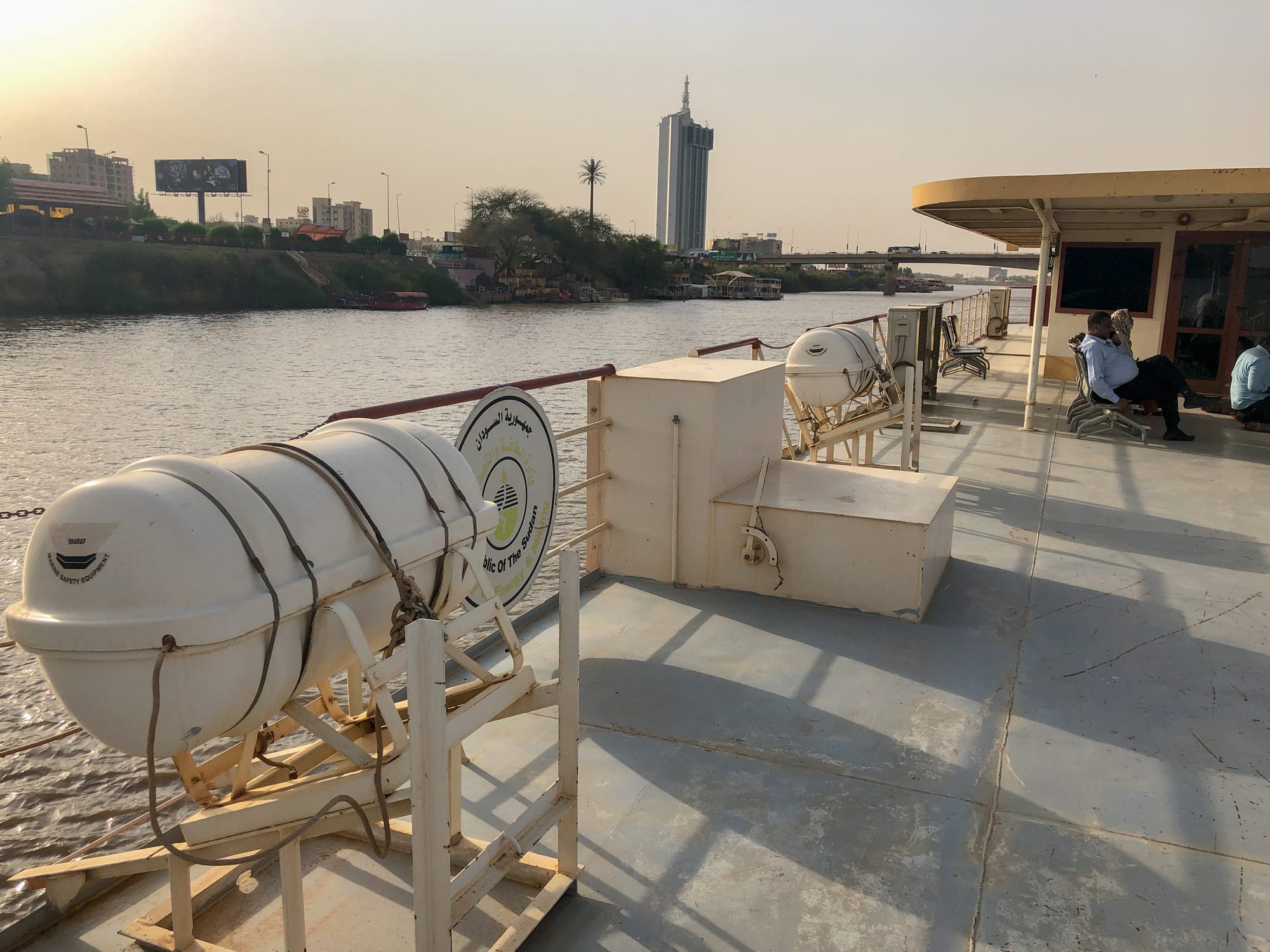
The Blue Nile at Khartoum seen from a boat deck at low sun, with a tall white tower on the far bank

Khartoum & Central Sudan, Sudan

Khartoum

The Blue Nile at Khartoum, upstream of the confluence with the White Nile. (Francisco Anzola / Wikimedia Commons · CC BY 2.0)

Sudan's capital, built where the Blue Nile and the White Nile join to form the main Nile, with Omdurman and Bahri facing it across the water as a single three-city capital. It grew from an Ottoman-Egyptian camp into the country's seat of government, commerce and learning, and was fought over between 2023 and 2025. This page is written to explain the city, not to encourage travel.

Neighbourhoods

  • Central Khartoum
    • First-time visitors
    • Historic district
    • Museums

    The colonial-era grid between the Blue Nile and the railway, laid out under Anglo-Egyptian rule. Government ministries, the Republican Palace, the university, the National Museum and the main souk stand within a few blocks of the river, along the avenue known as Nile Street. Much of it was damaged in the fighting of 2023 to 2025.

    Open in Maps
  • Omdurman
    • Historic district
    • Markets
    • Local life

    One of the three cities of the capital, on the west bank across the White Nile, founded as the Mahdist capital in the 1880s. Low mud-brick and concrete houses spread for miles around the Mahdi's tomb, the Khalifa's house and a very large souk, and the city is the home of Sudanese popular song and of Friday Sufi gatherings.

    Open in Maps
  • Khartoum North
    • Local life
    • Quiet and residential

    Known to everyone as Bahri, the third city, north of the Blue Nile and east of the main Nile. It held most of the capital's factories, workshops and river port alongside long residential streets, and it saw heavy fighting and looting during the war.

    Open in Maps
  • Tuti Island
    • Quiet and residential
    • Riverside walks

    A farming island of about four square kilometres sitting exactly in the angle of the two rivers, linked to Khartoum by a suspension bridge since 2008. Vegetable plots, palms and a village of narrow lanes give it a rural feel within sight of the city centre.

    Open in Maps
  • Amarat and Khartoum 2
    • Best for food
    • Quiet and residential

    Numbered residential districts south-east of the centre, built for the professional middle class and later filled with embassies, offices, clinics and most of the capital's restaurants and coffee shops. Streets are wide, walled and shaded by neem trees.

    Open in Maps

Things to do

The rivers and landmarks

  • Tuti Islandneighborhood

    The island in the angle of the Blue and White Niles, from whose banks the two rivers can be seen running side by side, one muddy and one pale, before they mix.

    Open in Maps
  • Tuti Bridgelandmark

    A suspension bridge opened in 2008 that replaced the ferries between central Khartoum and the island.

    Open in Maps
  • Republican Palacelandmark

    The riverside palace of the Anglo-Egyptian governors and later of Sudan's heads of state, where the Sudanese flag was raised at independence in January 1956; the old palace was destroyed during the war and the army retook the complex in March 2025.

    Open in Maps
  • University of Khartoumlandmark

    Founded in 1902 as Gordon Memorial College, the country's oldest university, with red-brick colonial buildings and gardens south of the Blue Nile.

    Open in Maps

Museums and monuments

  • National Museum of Sudanmuseum

    The country's main museum until the war, established in 1971, whose galleries and garden temples held the largest and most comprehensive Nubian archaeological collection in the world; after the army retook the city in March 2025 the head of the antiquities service said most of its 100,000 objects had been looted or smashed.

    Open in Maps
  • The Mahdi's tomblandmark

    The domed tomb of Muhammad Ahmad in Omdurman, its dome destroyed by Anglo-Egyptian gunboat fire after the Battle of Omdurman in 1898 and the building reconstructed in 1947 under the direction of his son; it is a place of pilgrimage rather than a tourist site.

    Open in Maps
  • Khalifa House Museummuseum

    The mud-brick house of the Khalifa Abdullahi, the Mahdi's successor, facing the tomb in Omdurman, which held weapons, banners and objects of the Mahdist state.

    Open in Maps
  • Sudan Ethnographic Museummuseum

    A small museum whose collections of crafts, musical instruments, dress and household objects from across Sudan's regions were looted and vandalised, like those of the capital's other museums, during the war.

    Open in Maps

Markets and street life

  • Souq al Arabimarket

    Khartoum's largest open-air market, a dense grid of stalls and shops spread over several blocks just south of the Great Mosque, selling cloth, gold, spices, electronics and food.

    Open in Maps
  • Nuba wrestlingattraction

    The wrestling of the Nuba Mountains, brought to the capital by migrants and held in open sand arenas in the capital's outer districts, with drums and large crowds.

    Open in Maps

Short trips from the city

  • Jebel Aulia Damlandmark

    A dam completed in 1937 on the White Nile about 40 km upstream of the capital, built to store water for Egypt and fitted with a hydroelectric plant in 2003; the bridge beside it was destroyed in fighting in November 2023, though officials said the dam itself was intact.

    Open in Maps

Seasonal events

  • Ramadan and Eid al-Fitrvaries with the lunar calendar

    The fasting month reshapes the day, with shared iftar meals spread on mats in the street at sunset, followed by the feast and family visiting of Eid.

  • Eid al-Adhavaries with the lunar calendar

    The feast of sacrifice, when sheep are bought at roadside markets, slaughtered at home and the meat shared with neighbours and the poor.

  • Independence Day1 January

    The anniversary of the 1956 raising of the Sudanese flag at the Republican Palace, marked by official ceremonies.

  • Friday Sufi gatheringsFriday afternoons, year-round

    In peacetime, Friday dhikr at a Sufi tomb in Omdurman drew drumming, chanting and whirling dervishes in green and red robes, watched by families and visitors.

Eat and drink

Long-standing places and food districts in Khartoum. Hours, ratings and directions come from your maps app, always current.

Khartoum classics

  • Ful and ta'amiya stallsrestaurant

    Breakfast across the capital is ful, broad beans simmered overnight and mashed with oil, cumin, cheese and onion, eaten from a shared bowl with bread, often with ta'amiya, the fried chickpea patties known elsewhere as falafel.

    Open in Maps
  • Nile fish grillsrestaurant

    Riverside stands and simple restaurants fry Nile perch and tilapia whole and serve them with lime, chilli salt and bread.

    Open in Maps

Markets and food districts

  • Souq al Arabimarket

    The central market, with spice and grain sellers, butchers, juice stalls and tea women working under awnings between the shops.

    Open in Maps
  • Amarat and Khartoum 2 restaurantsneighborhood

    The districts where the capital's sit-down restaurants and coffee shops concentrated, serving Sudanese grills, Levantine and Ethiopian food and espresso.

    Open in Maps

Tea and coffee

  • Street tea sellerscafe

    Women known as sittat al-shai set out low stools beside the road and brew sweet tea with mint or cinnamon and jebena coffee spiced with ginger and cardamom.

    Open in Maps

Experience Khartoum

History

Khartoum was founded in 1821 as an Ottoman-Egyptian military camp at the tip of land where the Blue and White Niles meet, and grew into the capital of Egyptian Sudan, a river port for the ivory and slave trades with a name commonly explained as coming from the Arabic for an elephant's trunk, the shape of the spit between the rivers. By the 1880s it was a town of government offices and merchants' houses along the Blue Nile.

In 1884 the forces of the Mahdi, Muhammad Ahmad, besieged the city; it fell in January 1885 and the governor-general, Charles Gordon, was killed. The Mahdist state abandoned Khartoum for Omdurman across the White Nile, which grew within a few years into a walled capital of hundreds of thousands. Kitchener's Anglo-Egyptian army defeated the Mahdists at Omdurman in 1898, and the condominium rebuilt Khartoum as a colonial capital, with a grid of avenues, the Republican Palace, Gordon Memorial College and a garrison, while Omdurman remained the Sudanese city and Khartoum North became the industrial one.

Independence was declared at the palace on 1 January 1956, and the capital then lived through decades of coups, expansion and waves of arrivals displaced by war and drought from the south, Darfur and Kordofan, who settled in vast districts on the outskirts. In 2019 a months-long sit-in outside the army headquarters helped bring down Omar al-Bashir. On 15 April 2023 fighting between the army and the Rapid Support Forces broke out in the capital itself, emptying much of it; the army declared Khartoum recaptured in March 2025, and the government returned from Port Sudan in January 2026.

Culture & Customs

The capital drew people from every corner of Sudan, and its culture is a meeting of them: riverine Arabic-speaking families from the north, Nubians, westerners from Darfur and Kordofan, Beja from the east and southerners who stayed after the 2011 partition. Arabic in its Sudanese dialect is the common language, and English is widely used in universities and business.

Religious life is shaped by Sufism. The great orders and religious families — the Ansar, followers of the Mahdi's descendants, and the Khatmiyya of the Mirghani family — built political parties as well as congregations, and in peacetime the Friday dhikr at a Sufi tomb in Omdurman, with drumming, chanting and whirling dervishes in patched robes, was among the capital's best-known public rituals.

Omdurman is the home of modern Sudanese song. The haqiba style of the early twentieth century, sung to clapping and tambourine, shaped everything that followed, and the capital's radio carried singers such as the Nubian star Mohammed Wardi, whose career began in the late 1950s, across the country. Poetry, calligraphy and painting have long been strong, and the College of Fine and Applied Art in Khartoum trained many of the modernist painters who emerged from the 1960s. Hospitality is a point of honour: a stranger is given water and tea before any question. Weddings run for days, with the jirtig ceremony of red silk, gold and perfume and a henna night, and football, played and argued over everywhere, is dominated by the Omdurman clubs Al-Hilal and Al-Merrikh.

Daily Life

Before the war, greater Khartoum held an estimated seven million people across its three cities and dominated the country's government, trade, universities, hospitals and industry. Millions fled after April 2023, and although people have returned to damaged homes since the army retook the city in 2025, the population now is impossible to state with any confidence.

The pre-war rhythm began early, with work before the midday heat, a long break in the worst of it, and evenings outdoors on the Nile banks or in courtyards. Tea sellers set up under the neem trees, government offices and shops closed in the afternoon, and Friday was the day of prayer, family visits and picnics on Tuti Island. Neighbourhoods ran on a strong sense of the hayy, the quarter, where neighbours share food and attend each other's weddings and funerals.

Work was in ministries and offices, the souks, the workshops and food factories of Bahri, and the informal trades of the outer districts, where families displaced by earlier wars had built whole towns of brick and sheet metal. The war overturned all of it: markets, banks, the airport and the National Museum were looted or damaged, universities closed, and power, water and health care largely failed. Volunteer-run neighbourhood emergency rooms became a lifeline, and the city's recovery is now measured in restored water pipes and reopened bakeries.

Food

Khartoum eats the Sudanese staples in their fullest form. The day starts with ful, broad beans stewed overnight and mashed with oil, cumin, white cheese and chopped onion, served in a shared metal bowl with bread and often with ta'amiya, fried chickpea patties. Kisra, a thin fermented sorghum flatbread, and asida, a stiff porridge, are eaten with mullah, the family of stews built on okra, dried meat, peanut butter or spinach-like greens; gurasa, a thicker pancake bread, is eaten the same way.

Meat matters. Grilled lamb and beef, agashe skewers rubbed with peanut and chilli spice, and kammouniya, a cumin-scented stew of liver and other offal, are sold in market grill houses, and shayyah, meat fried with its own fat, is a favourite of the souks. Fish from the Nile is fried whole by the river. Salads of tomato and cucumber, salata aswad made from smoked aubergine and peanut butter, and dakwa, peanut paste stirred into many dishes, round out a meal.

Drinks are central to social life. Street tea sellers, usually women, pour sweet tea with mint or cinnamon, and jebena coffee is roasted, pounded with ginger and cardamom and poured from a clay pot through a grass filter. Karkade, cold hibiscus infusion, and aradaib, made from tamarind, are drunk against the heat, and during Ramadan families break the fast with hilu-mur, a dark spiced drink made from fermented sorghum flakes. Alcohol has been illegal for Muslims since 1983, when Islamic law was introduced, though a change in 2020 allowed non-Muslims to drink.

Planning tools

Budget

Khartoum was the most expensive place in Sudan before 2023, though cheap by international standards, and the war has made any budget meaningless. Banks and cash machines barely function, prices for food, fuel and transport have soared, and there is no visitor economy. The figures below describe pre-war conditions for reference only.

Daily Budget Midrange
USD 70–150 pre-war equivalent in Sudanese pounds (Khartoum hotel, restaurants, a hired car and driver); no meaningful budget during the war
Daily Budget Shoestring
USD 30–50 pre-war equivalent in Sudanese pounds (simple hotel, street food, minibuses); no meaningful budget during the war

Do not plan travel here while the war continues; before it, Sudan was a cash-only economy for visitors, with no international cards.

Best Time to Visit

In peacetime the season was November to February, when the heat is bearable and the air dry. From April to June the city is among the hottest large cities on earth, and July to September brings dust storms and short, heavy downpours that flood unpaved streets. No season is suitable for travel while the war continues.

Suggested Number of Days

Before the war, two or three days covered the three cities either side of the rivers, and four or five allowed for the Gezira or the desert sites north of the capital. Heat, distances and permits slowed everything down.

First Visit
2–3 days
With Surroundings
4–5 days

Transportation

Greater Khartoum is very spread out, and movement between its three cities depended on a handful of bridges over the two Niles. Minibuses, shared amjad taxis and rickshaws carried most people. The bridges, roads and river crossings were fought over from 2023, and fuel and electricity remain scarce.

There is no safe way for visitors to move around the city at present.

Airport & Station Connections

Khartoum International Airport sits in the middle of the city, a few kilometres south-east of the centre. It was attacked when the war began in April 2023 and stayed closed until the army regained the site in March 2025; domestic flights resumed in October 2025 and international flights in April 2026, and the airport has been hit by drone attacks since. A New Khartoum International Airport south of the city has long been under construction. Paved highways run south to Wad Madani and north along the Nile, and Port Sudan on the Red Sea became the country's main gateway during the war.

Walkability

The colonial grid of central Khartoum is walkable in the cool months, with the museum, the palace, the university and the souk within a kilometre or so of one another, though the heat limits walking to early morning and evening. Beyond the centre, distances are long, pavements irregular and the bridges to Omdurman and Bahri too far to cross on foot comfortably.

Safety

Do not travel. Since April 2023 the Sudanese Armed Forces and the Rapid Support Forces have fought across Khartoum, Omdurman and Bahri, with shelling, air strikes, drone attacks, looting, killings of civilians and sexual violence. The army declared the capital recaptured in March 2025 after fighting that left widespread destruction, and the government returned in January 2026, but drone strikes on the capital continued. Hospitals, power and water have largely failed, and unexploded ordnance is a hazard.

Most governments advise against all travel to Sudan, and there is no consular help on the ground. Check current official travel advice before travelling.

Climate

Hot desert climate with very little rain. Heat builds from March, peaks before the rains and eases in November; haboob dust storms sweep in from the desert at the start of the rainy season, turning the sky orange for an hour or more.

Summer
very hot, often 40–45°C in May and June, with short rains and dust storms from July to September
Winter
warm, dry and pleasant, around 30°C by day with cool nights from December to February

Local Customs

Sudan is a conservative Muslim society and Khartoum is its most mixed city. Modest dress covering shoulders and knees is expected of everyone, and many women wear the tobe, a long wrapped cloth. Greetings are unhurried, the right hand is used for eating and giving, and hospitality is taken seriously — tea or a meal is offered before any business. Alcohol has been illegal for Muslims since 1983, and non-Muslims were permitted to drink from 2020.

Photography of bridges, airports, government buildings, soldiers and checkpoints is prohibited, and a photography permit was required even in peacetime; always ask before photographing people. Tipping is not expected, though small change is appreciated.

Common Payment Methods

The currency is the Sudanese pound (SDG), which has lost most of its value, with a wide gap between official and street exchange rates. International cards and cash machines do not work because of sanctions, so the economy has long run on cash, with US dollars carried in for exchange; mobile money apps became widely used before the war and banking is now badly disrupted.