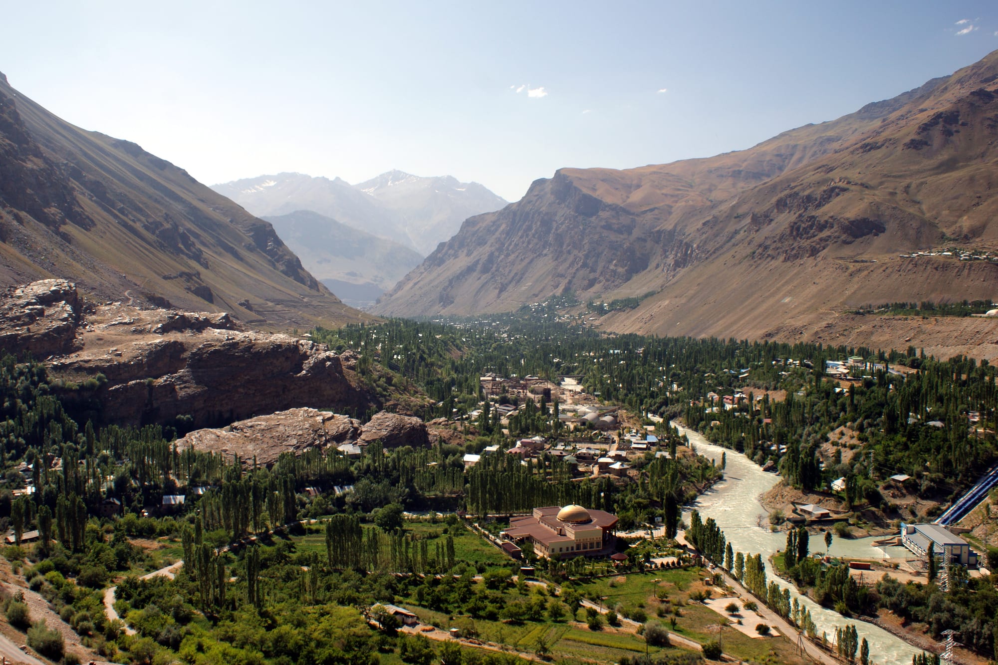
A green valley town of trees and low buildings along a pale river, hemmed in by bare brown mountains with snow peaks in the distance

The Pamirs, Tajikistan

Khorugh

Khorugh in the Gunt valley, seen from the slope of the botanical garden above the town. (Kondephy / Wikimedia Commons · CC BY-SA 4.0)

The capital of Tajikistan's Gorno-Badakhshan region and the only real town of the Pamirs, strung for several kilometres along the Gunt river where it meets the Panj at about 2,200 metres. Grown from a Russian garrison post of the 1890s, it is a poplar-lined valley town of Ismaili Pamiris, a university campus and a botanical garden high on the slope above.

Neighbourhoods

  • The centre and the main street
    • First-time visitors
    • Local life
    • Close to transport

    The administrative and commercial core along the main street, with government buildings, shops, banks and most of the town's hotels. The park by the river, cafés and the main taxi stands are all within a few minutes' walk.

    Open in Maps
  • The bazaar quarter
    • Best for food
    • Markets
    • Local life

    The market end of town, where produce trucked up from the lowlands is sold beside local fruit, dried mulberries, bread and imported goods. Shared taxis for the Wakhan, Murghab and Dushanbe gather near by, and the area is busiest in the early morning.

    Open in Maps
  • Along the Gunt
    • Quiet and residential
    • Walking
    • Views

    The long residential strip of single-storey houses, vegetable plots and poplars that follows the river upstream and downstream from the centre. Footbridges cross the fast grey water, and the valley walls rise steeply on both sides.

    Open in Maps
  • The upper slopes and the university
    • Views
    • Gardens
    • Students

    The terraces above the valley floor, where the University of Central Asia campus and the botanical garden look down on the town. The climb is steep but short, and the views take in the whole length of Khorugh and the mountains beyond.

    Open in Maps

Things to do

In and above the town

  • Pamir Botanical Gardenpark

    A high-altitude botanical garden on the slope above the town, the second highest in the world, established in 1940 to test how plants from other mountain regions survive here.

    Open in Maps
  • The city parkpark

    The riverside park in the centre, with paths, trees and monuments, the town's main gathering place on summer evenings.

    Open in Maps
  • Khorugh bazaarmarket

    The covered and open market at the eastern end of town, where mountain produce, dried fruit and goods brought up the highway are traded.

    Open in Maps
  • Khorugh Regional Museummuseum

    A small local museum covering the natural history, archaeology and ethnography of the Pamirs, including Pamiri house interiors and musical instruments.

    Open in Maps

The rivers and the valleys

  • Guntattraction

    The river that runs the length of the town before joining the Panj, fed by snowmelt and lined with poplars and footbridges.

    Open in Maps
  • Panjattraction

    The river that forms the border with Afghanistan at the western edge of town, its far bank a line of Afghan Badakhshan villages and tracks.

    Open in Maps

Short trips from the town

  • Garm Chashmaattraction

    Hot springs about 40 kilometres south at around 2,325 metres, where mineral water at up to 75°C bubbles from small geysers among pale mineral terraces, with bathing houses beside them.

    Open in Maps
  • Shughnon Districtattraction

    The district around the town, a string of Pamiri villages, orchards and side valleys along the Panj and the Shakhdara.

    Open in Maps

Seasonal events

  • NowruzMarch

    The Persian new year, celebrated across the Pamirs with house cleaning, special dishes, music and public gatherings as the valleys begin to thaw.

  • Imamat Daythe anniversary of the Imam's accession

    The day on which Nizari Ismailis mark the accession of the Imam of the Time, observed in Khorugh and the surrounding villages with gatherings and celebrations.

  • Independence DaySeptember

    Tajikistan's national day on 9 September, marked with concerts, sport and official events in the town centre.

Eat and drink

Long-standing places and food districts in Khorugh. Hours, ratings and directions come from your maps app, always current.

Pamiri classics

  • Qurutobrestaurant

    Layers of torn flatbread soaked in a sauce of reconstituted dried yoghurt and topped with onion, herbs and sometimes meat, eaten from a shared dish by hand.

    Open in Maps
  • Shirchoycafe

    Milk tea, salted and often thickened with butter and torn bread, the standard breakfast in Pamiri households and homestays.

    Open in Maps

Markets and tea houses

  • Khorugh bazaarmarket

    Dried mulberries and apricots, walnuts, bread, tea and fresh produce, with grills and small eating places among the stalls.

    Open in Maps
  • Cafés on the main streetcafe

    A handful of small cafés and canteens in the centre serving soups, shashlik, plov, pastries and tea to office workers and students.

    Open in Maps

Experience Khorugh

History

The valleys that meet at Khorugh belonged for centuries to Shughnan, one of the small Pamir principalities ruled by local mirs and tied loosely to Badakhshan across the Panj. Ismaili Islam had reached these mountains by the 11th century, and tradition credits its spread to the poet and missionary Nasir Khusraw, who spent the last decades of his life in Badakhshan, in what is now northern Afghanistan. Settlement clung to irrigated terraces where side streams could be led onto the stony valley floor.

The town as such dates from the Great Game. Russian forces established posts in the Pamirs in the 1890s, and a garrison at the confluence of the Gunt and the Panj grew into the administrative centre of the western Pamirs. The boundary agreement of 1895 fixed the Panj as the frontier with Afghanistan, cutting Shughnan in two and leaving families divided by a river a few dozen metres wide. Under Soviet rule Khorugh became the capital of the Gorno-Badakhshan Autonomous Region, created in 1925, and acquired schools, a hospital and the botanical garden, established in 1940.

Isolation ended slowly: the Pamir Highway, pushed through in the 1930s, gave the town its lifeline to Dushanbe and Osh. During the civil war of 1992 to 1997 the region sided largely with the opposition and was cut off and close to famine until relief organised by the Aga Khan reached it, and the Aga Khan Development Network has been central to the town's life since, funding schools, clinics, power schemes and a campus of the University of Central Asia. Relations with the national government have remained difficult, with armed clashes in the town in 2012 and a security operation after protests in 2022.

Culture & Customs

Khorugh is the cultural centre of the Pamiris, who differ from most Tajiks in both faith and language. They are Ismaili Shia Muslims who follow the Aga Khan, and their prayer houses, ceremonies and calendar are distinct from the Sunni mainstream of the country. At home people speak Shughni, an Eastern Iranian language of a different branch from Tajik, and the town hears Rushani, Wakhi, Bartangi and other Pamiri languages from visitors and students out of the surrounding valleys, with Tajik and Russian used in offices and schools.

Music is central. Maddoh, a devotional genre of sung praise accompanied by the long-necked rubab and frame drums, is performed at gatherings and mourning ceremonies, and the town's musicians are known across Tajikistan. The Pamiri house, the chid, is itself a cultural object: a single room whose wooden pillars and stepped skylight carry meanings traced to pre-Islamic belief, and celebrations, meals and funerals all take place within it.

Education is prized, and Khorugh has an unusual concentration of teachers, doctors and graduates for a remote mountain town. Many young people study in Dushanbe or abroad and return in the summer, and the University of Central Asia campus has brought students from across the region. Manners are warm and informal by Tajik standards, hospitality to travellers is close to obligatory, and both the 2012 and 2022 events are still felt keenly, so political questions are best left to local people to raise.

Daily Life

About 30,000 people live in Khorugh, which makes it by far the largest place in a region of some 230,000 spread across nearly half of Tajikistan's territory. The town is essentially one long street along the Gunt, with houses, vegetable gardens and poplars filling the valley floor and the mountains rising sharply on either side. Public employment matters more than in most Tajik towns: regional government, schools, the hospital, the university and the organisations of the Aga Khan network are the main employers, alongside trade, transport and small businesses.

Household economies rest on a mix of sources — a salary, a plot of land, animals kept in a village up the valley, and remittances from relatives working in Russia. Electricity comes from hydroelectric plants on the Gunt and is more reliable than in many parts of the country. Goods arrive by truck over the passes, so prices rise when the road closes, and families lay in flour, rice and fuel before winter.

The rhythm of the day starts early at the bazaar and at the taxi stands, slows in the afternoon, and brings people out to the park and the riverside in the evening. Winter is long and enclosed, with short daylight in the deep valley and snow on the surrounding slopes. Security checkpoints and the presence of the border regime are part of ordinary life, and cross-border contact with Afghan Badakhshan, once maintained through markets on the river, has become far more restricted than it was.

Food

Pamiri food is mountain food: bread, dairy and whatever the short season allows, served generously. Qurutob, the national dish of Tajikistan, is made from dried yoghurt balls, qurut, soaked back into a sauce and poured over torn flatbread, then topped with fried onion, herbs and sometimes meat, and eaten by hand from a shared platter. Shirchoy, tea boiled with milk, salt and often butter, with bread broken into it, is the standard breakfast and a defence against cold mornings.

Flatbread is baked at home in flat rounds rather than in the tall tandoors of the lowlands. Dairy fills much of the rest of the diet: fresh cheese, sour milk, kaymak, a thick clotted cream, and qurut both as a sauce and as a hard salty snack. Soups of barley, potato and mutton are everyday dishes, and noodle dishes and plov appear for guests, though rice is carried up from the lowlands and treated accordingly. Meat is mostly mutton, goat and, from the eastern plateau, yak.

The irrigated terraces around the town grow apricots, apples, walnuts and mulberries. Mulberries are eaten fresh in summer and dried by the sack for winter, sometimes ground into a sweet flour, and dried apricots and walnuts are the standard accompaniment to tea. Fresh vegetables are seasonal and imported food is expensive, so the bazaar's stock changes sharply through the year. Tea is drunk constantly, and meals begin and end with it.

Planning tools

Budget

Prices in the town itself are low, but Pamir travel costs are dominated by transport: a place in a shared car or a share of a chartered 4x4 with driver. Hotels in Khorugh are simple, homestays in the surrounding villages cheaper still and usually include dinner and breakfast. Food, fuel and bottled goods cost more than in the lowlands because everything is trucked in.

Daily Budget Midrange
USD 95–190 (a share of a hired 4x4 and driver, homestays or Khorugh hotels, a guide)
Daily Budget Shoestring
USD 30–60 (homestay or guesthouse with meals, bazaar food, shared taxis)

Bring enough cash in somoni and US dollars for the whole Pamir trip; the town's cash machines are unreliable and there are none beyond it.

Best Time to Visit

July to September is the main season, when the passes are clear, the valley is green with orchards and homestays are open. June and early October are colder and carry a risk of snow on the high roads. Winter is long and quiet, with the highway subject to closure and daylight short in a deep valley.

Suggested Number of Days

The town itself takes a day or two, and many travellers use it mainly to rest, resupply and arrange transport. A week allows the surrounding valleys and the routes east and south, and a spare day or two is worth keeping back for road closures.

First Visit
1–2 days
With Surroundings
5–7 days

Transportation

There is no public transport of the usual kind. Shared cars and 4x4s leave from stands near the bazaar for Dushanbe, for Murghab and for the villages of the Wakhan and the Shakhdara and Bartang valleys, filling up in the early morning. Within the town, shared taxis run along the single main road, and most people walk. Hired vehicles with a driver are the usual way to travel onward.

Arrange onward transport a day in advance where possible, and expect journey times to change with landslides, roadworks and river levels.

Airport & Station Connections

Most visitors arrive by road on the Pamir Highway from Dushanbe, a journey usually split over two days by shared 4x4, or from Murghab in the east in a long day. The town has a small airport, and Tajik Air has flown between Dushanbe and Khorugh since September 2024, a flight of about an hour and ten minutes on a small turboprop that depends on the weather over the mountains. A GBAO permit is required to enter the region.

Walkability

Khorugh is long and narrow, strung for several kilometres along the Gunt, so walking the length of it takes time, but the centre, the park and the bazaar are close together and easily covered on foot. Footbridges cross the river, pavements are patchy, and the climb to the botanical garden and the university is steep. The altitude of about 2,200 metres makes uphill walking harder than it looks.

Safety

The Pamirs are hospitable and ordinary crime is rare, but the region has a history of tension with the central government: armed clashes in Khorugh in 2012 and a security operation after protests in 2022 left many dead, and extra checkpoints have followed. The Afghan border along the Panj is closely guarded, and photography near it is unwise. Altitude, cold, remote roads and limited medical care are the everyday risks.

Check the current situation in GBAO before setting out, carry the GBAO permit and several copies of it, stay away from the riverbank near the border and from any gathering or checkpoint, and keep insurance with evacuation cover. Check current official travel advice before travelling.

Climate

A dry mountain climate in a deep valley at about 2,200 metres. Summers are warm, sunny and almost rainless, with cool nights; winters are cold but less severe than on the eastern plateau, with snow in the valley and heavy snow on the passes above.

Summer
warm and dry — days commonly 25–30°C, with nights falling to around 10°C
Winter
cold — January days are typically around -2 to 2°C with nights near -10°C, with snow in the valley and closed roads above

Local Customs

Most people here are Ismaili Shia Muslims who follow the Aga Khan, and religious life centres on the jamoatkhona, the prayer house, rather than a mosque; these are not tourist sites and should be entered only if invited. Dress is modest but less formal than in the Sunni lowlands. Shoes come off at the door of a house, guests are seated at the head of the room, and hospitality is a serious obligation.

Ask before photographing people, houses or prayer houses, never photograph soldiers, checkpoints or the Afghan bank of the river, and accept tea when it is offered. Tipping is not expected, though a gift for a homestay family is welcome.

Common Payment Methods

The currency is the Tajikistani somoni. Khorugh is the last place in the region with banks and cash machines, and these are not reliable, so travellers usually carry all the cash they will need. US dollars in good condition can be exchanged in town. Cards are accepted at very few places, and homestays, drivers and the bazaar are cash only.