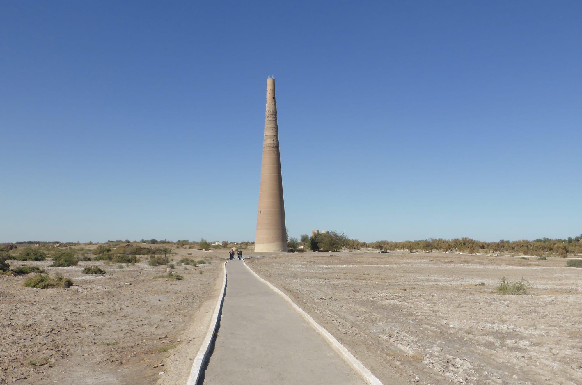
A tall tapering brick minaret standing alone on a flat, dry plain at the end of a narrow paved path under a clear blue sky

Ashgabat, Kunya-Urgench & the Karakum, Turkmenistan

Konye-Urgench

The Kutlug-Timur minaret rising above the ruins of old Urgench in northern Turkmenistan. (Hans Birger Nilsen / Wikimedia Commons · CC BY-SA 2.0)

A small town in the far north of Turkmenistan, near the Uzbek border in Daşoguz province, beside the ruins of Urgench, capital of medieval Khwarazm. Sacked by the Mongols in 1221 and again by Timur, the old city was abandoned when the Amu Darya shifted course, leaving a plain of brick minarets and tiled mausolea listed by UNESCO. This page is written to explain the town, not to encourage travel.

Neighbourhoods

  • The archaeological park
    • First-time visitors
    • Historic district

    The open ground beside the modern town where the surviving monuments of old Urgench stand, scattered across a dusty plain among cemeteries. Paths link the minaret and the mausolea, and there is almost no shade.

    Open in Maps
  • The town centre
    • Local life
    • Markets

    A low grid of Soviet-era blocks, shops, offices and a bazaar serving the surrounding cotton farms. It is a working provincial town rather than a tourist centre, with a handful of simple places to stay and eat.

    Open in Maps
  • The irrigated outskirts
    • Quiet and residential
    • Countryside

    Villages, canals and cotton and wheat fields spread around the town on water drawn from the Amu Darya, with flat-roofed houses, poplar windbreaks and livestock along the lanes towards the Uzbek border.

    Open in Maps

Things to do

The monuments of old Urgench

  • Kutlug-Timur Minaretlandmark

    A tapering brick minaret 60 metres tall, standing alone on the plain, first built in the 11th century and restored by Kutlug-Timur around 1330.

    Open in Maps
  • The Kunya-Urgench monumentslandmark

    The field of ruins in and beside the modern town, inscribed by UNESCO in 2005: tiled mausolea, the gates of a caravanserai and earthen fortress mounds among cemeteries, all that is left of Gurganj, the medieval Khwarazmian capital.

    Open in Maps

Around the town

  • Daşoguzneighborhood

    A low cotton city about 85 kilometres east, with the region's airport and most of its hotels.

    Open in Maps
  • Khivalandmark

    The walled Uzbek oasis city that replaced old Urgench as the capital of Khwarazm, reached through the border crossing near the town.

    Open in Maps

Seasonal events

  • Nowruzlate March

    The spring new year, marked across the north with family meals, music and the cooking of semeni from sprouted wheat.

  • Melon DayAugust

    A national holiday for the Turkmen melon, celebrated in a region that grows large quantities of them.

  • The cotton harvestSeptember to November

    The defining season in the Daşoguz oasis, when the fields, roads and gins around the town are at their busiest.

Eat and drink

Long-standing places and food districts in Konye-Urgench. Hours, ratings and directions come from your maps app, always current.

Markets and local food

  • Konye-Urgench bazaarmarket

    The town market, selling melons, tomatoes, dried fruit, rice and mutton from the surrounding farms, with tandoor bread baked alongside.

    Open in Maps
  • Tandoor bakeries and somsa stallsneighborhood

    Clay ovens around the centre turn out round chorek loaves and somsa, meat-and-onion pastries baked against the oven wall.

    Open in Maps
  • Chaikhanas and simple restaurantsneighborhood

    Plain tea houses and canteens near the centre serving chorba soup, palow, manty and lagman, with green tea throughout.

    Open in Maps
  • Daşoguz restaurantsneighborhood

    The provincial capital has the wider choice of places to eat, including Turkmen and Uzbek dishes reflecting the region's mixed population.

    Open in Maps

Experience Konye-Urgench

History

The town takes its name — old Urgench — from the city that stood here as the capital of Khwarazm, the irrigated land along the lower Amu Darya. Urgench grew rich on the caravan routes between Iran, the Volga and China, and by about 1200 the Khwarazmshahs ruled an empire stretching across Central Asia and into Iran. Contemporary writers described it as one of the great cities of the Islamic world, with mosques, madrasas and libraries; the mathematician al-Khwarizmi and the scholar al-Biruni came from this region.

In 1221 the Mongol armies of Genghis Khan besieged the city after the killing of his envoys. Urgench held out for months and was destroyed, its dams broken and its population massacred. It recovered under the Golden Horde during the 14th century, when the governor Kutlug-Timur and his wife gave their names to the minaret and, by tradition, the tiled mausoleum that are the finest monuments on the site. That revival ended in the 1380s, when Timur's forces sacked the city again.

What finished old Urgench was water. The Amu Darya shifted its channel, leaving the city without irrigation, and in the 16th century the rulers of Khwarazm had moved their capital to Khiva, taking much of the population with them. The site was left as a field of ruins and graves outside a small modern settlement, which grew again in Soviet times as a cotton town. The monuments were inscribed on the UNESCO World Heritage List in 2005.

Culture & Customs

Konye-Urgench is a religious place as much as an archaeological one. The mausolea draw pilgrims from across Turkmenistan and neighbouring Uzbekistan, particularly to the tomb associated with Najm ad-Din Kubra, the 13th-century founder of the Kubrawiya Sufi order, who is said to have died in the Mongol attack. Visitors walk between the shrines, circle them, leave small offerings and tie strips of cloth to frames; some sleep nearby, and newly married couples come to be blessed. Cemeteries have grown around the monuments over centuries, so the ruins sit among graves.

The region belongs to historic Khwarazm and looks culturally towards Khiva as much as towards Ashgabat. A large share of the local population is ethnic Uzbek, and Uzbek is widely spoken alongside Turkmen; music, dress and food all carry Khorezmian as well as Turkmen features. Carpet patterns, embroidery and the heavy silver jewellery worn by brides differ in detail from those of the south.

Social life follows the national pattern. Weddings are large, public and central to the calendar, with music and feasting late into the night, and the whole extended family is involved in the arrangements. Hospitality is expected of hosts and accepted by guests: tea is poured immediately, bread is treated with care, and elders are greeted first and served first.

Daily Life

About 37,000 people live in the town, in a district of villages and irrigated fields that supports many more. The economy is agricultural: cotton above all, along with wheat, rice, melons and vegetables grown on canal water drawn from the Amu Darya, with cotton gins, small food-processing plants and the trade that comes with a nearby international border. State farms and quotas shape the working year, and the autumn harvest pulls in labour from across the district.

Everyday life is quiet and low-rise. Families live in single-storey courtyard houses or Soviet apartment blocks, shop at the bazaar rather than in shops, and travel between villages in shared cars and minibuses. Days start very early in summer to avoid the heat, and the afternoon is spent indoors. Livestock, poplar windbreaks and irrigation ditches line the lanes outside town.

The north's persistent difficulties are water and salt. This is part of the wider Aral Sea basin, where decades of irrigation have lowered river flow and left salt in the soil, and drinking water quality is a long-standing problem; tea is often drunk with milk to soften it. Work is limited, so many households depend on relatives working in Turkmenabat, Ashgabat or abroad, and the internet is slow and heavily filtered. For all that, the town is neat and orderly, and the monuments give it a steady trickle of visitors.

Food

The food here is Turkmen with a strong Khorezmian accent, shaped by the Uzbek population and by what the oasis grows. Chorek, the round loaf baked against the wall of a clay tandoor, is on every table and treated with respect. Palow — rice slow-cooked with mutton, carrot and onion — is the dish for guests, weddings and holidays, and the northern version is close to the Khorezmian style across the border. Chorba, a mutton and vegetable soup, and dograma, torn bread with boiled meat and onion in broth, cover everyday and feast days respectively.

Bazaar food is quick and filled: somsa baked in the tandoor, gutap fried in half-moons with meat, pumpkin or greens, manty steamed in stacks, and lagman noodles in broth, a dish shared with the whole region. Shashlik over charcoal appears wherever there are crowds. Gatyk, a thick sour yoghurt, and suzma, its drained form, accompany meals and cool the heat.

The land's pride is fruit. Melons and watermelons from the Daşoguz oasis are famous within the country and have their own national day in August; grapes, apricots, pomegranates and mulberries follow through the season, and much of the crop is dried for winter. Green tea is drunk from bowls throughout the day, and in the north it is often taken with milk, a habit that also softens the salty local water. Fish from the Amu Darya turns up on tables closer to the river.

Planning tools

Budget

Costs are set by the guided tour rather than by the town, which has few facilities of its own. Most visitors come on a day trip from Daşoguz or break the journey here between Ashgabat and the Uzbek border, so the bill covers the guide, driver, permits and a hotel elsewhere. Local prices in manat are very low, but visitors pay mostly in US dollars cash.

Daily Budget Midrange
USD 180–300 (full guided tour, hotel, car and driver, internal flight to Daşoguz)
Daily Budget Shoestring
USD 120–180 (transit route with a guide, simple hotel in Daşoguz, bazaar food)

Carry enough clean, new US dollar notes; there is nothing here that reliably takes a foreign card.

Best Time to Visit

April to May and late September to October. The monuments stand on open ground with no shade, so spring and autumn are the only comfortable times to walk between them. The north is colder than southern Turkmenistan in winter, with frost and occasional snow, and midsummer is punishing by midday.

Suggested Number of Days

The archaeological park is usually covered in a few hours, and many visitors stop only for a morning or an afternoon. A night in the provincial capital makes the trip easier, and border crossings towards Uzbekistan often set the timing rather than the town itself.

First Visit
Half a day to a day
With Surroundings
1–2 days

Transportation

Visitors travel by car with their guide, which is the only practical way to reach the town and to move between the monuments, as they are spread over a wide area. A shared taxi culture serves local people between Daşoguz and the town. Walking is the way to cover the park itself once the car has stopped.

Ask the driver to wait between clusters of monuments; distances across the site are longer than they look on the flat ground.

Airport & Station Connections

Daşoguz, about 85 kilometres east, has the regional airport with domestic flights from Ashgabat and is the usual base; the road from there takes roughly two hours. The road south across the Karakum links the region to the capital, passing Darvaza. The Uzbek border crossing used by travellers heading for Khiva lies close by, which is why many visits here fall at the start or end of a Turkmen tour.

Walkability

The monuments are visited on foot, on flat paths and dusty ground, with long open stretches between the minaret, the mausolea and the mound and almost no shade or shelter. The modern town is small and easily walked, though it holds little for visitors. Sturdy shoes, a hat and water make the difference.

Safety

Crime against visitors is very low and guides accompany tours throughout. The practical risks are heat, dust and dehydration on unshaded ground, uneven footing among ruins and cemeteries, and the border zone: this is close to Uzbekistan, and checkpoints, permits and restrictions on photographing official or military sites apply.

Carry water and sun protection, keep passport and permits to hand near the border, and ask the guide before photographing anything official. Check current official travel advice before travelling.

Climate

A cold desert climate on the northern lowlands, drier and more extreme than the capital. Rainfall is very low, dust blows off the surrounding desert and salt flats, and the seasons swing sharply between short spring and autumn windows.

Summer
very hot and dusty, frequently 35–42°C with strong sun and little shade
Winter
cold for Turkmenistan, generally around -5 to 8°C, with frost and occasional snow

Local Customs

The monuments are an active place of pilgrimage as well as an archaeological site: people circle the mausolea, tie cloth to shrines and pray, particularly at the tomb associated with the Sufi teacher Najm ad-Din Kubra. Modest dress is expected, heads are covered by women at shrines and shoes removed where indicated. Much of the local population is ethnic Uzbek as well as Turkmen, and both languages are heard.

Keep quiet and at a distance from people praying, ask before photographing anyone at a shrine, and follow the guide's instruction on photography near the border or official buildings.

Common Payment Methods

The currency is the Turkmen manat, at a fixed official rate. Cash is the only realistic means of payment here: international cards do not work, cash machines are scarce and often empty, and the tour itself is paid in US dollars arranged in advance. Small manat notes are useful at the bazaar.