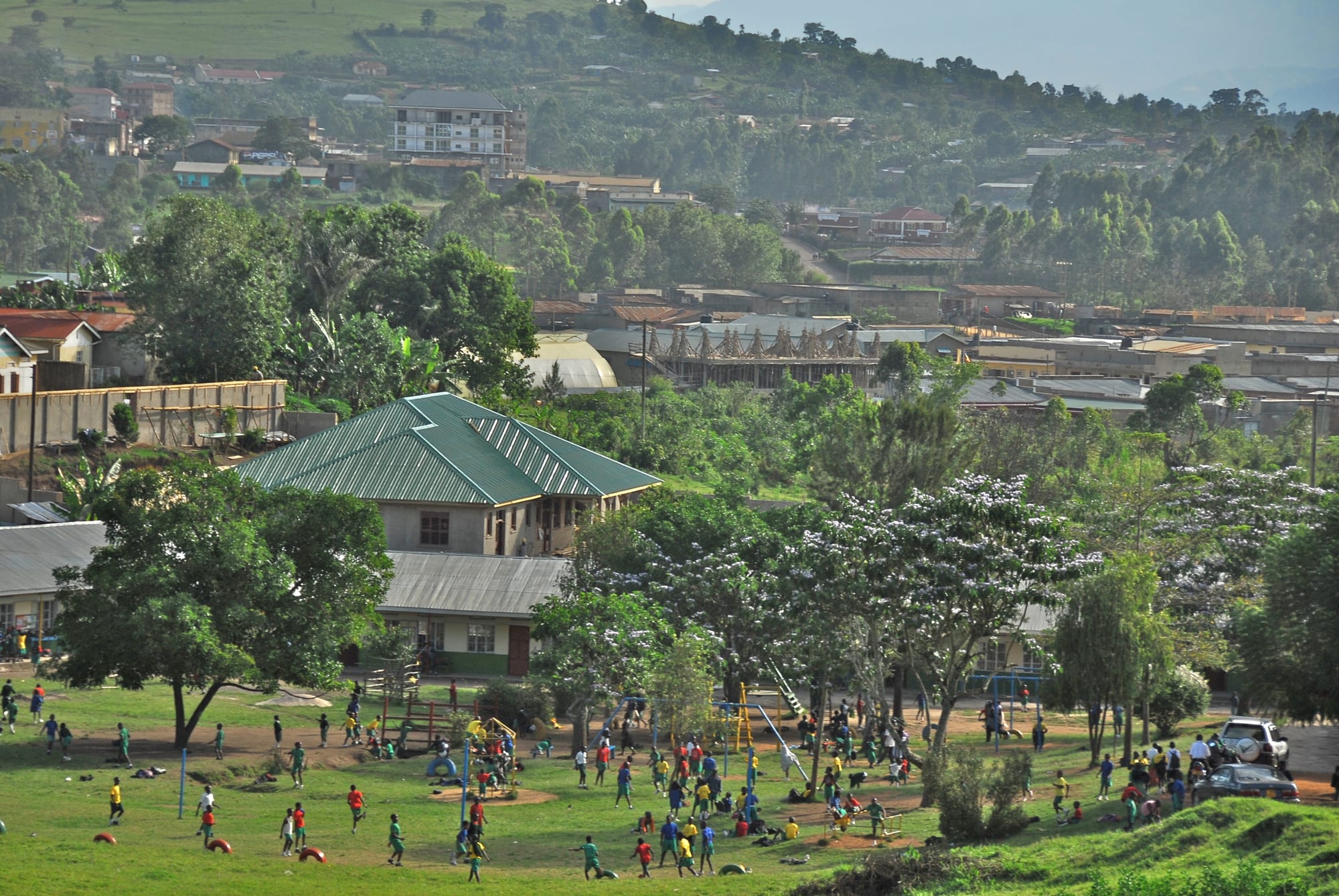
Fort Portal seen from a hillside, with green playing fields, tin-roofed buildings among trees and wooded hills behind

Bwindi, the Rwenzoris & the West, Uganda

Fort Portal

Fort Portal spread across its hills in western Uganda, seen from above the town. (Dave Proffer / Wikimedia Commons · CC BY 2.0)

A hill city in western Uganda, seat of the Tooro kingdom and centre of the country's main tea-growing district. It sits at about 1,500 metres below the Rwenzori Mountains, ringed by dozens of volcanic crater lakes and close to the chimpanzee forest of Kibale, which has made it the usual base for travel in this part of the west.

Neighbourhoods

  • The town centre
    • First-time visitors
    • Shops and banks
    • Transport

    The grid of streets around the main roundabout, where the banks, supermarkets, bus offices and most of the restaurants are. It is small enough to cross in fifteen minutes, and on clear mornings the Rwenzori snowline shows at the end of the western streets.

    Open in Maps
  • Mpanga and the market
    • Markets
    • Local life
    • Street food

    The busy quarter around the central market and the Mpanga river below the centre, where produce lorries unload and traders sell potatoes, bananas, fish and second-hand clothes. Loud, crowded and the cheapest place in the city to eat.

    Open in Maps
  • The Boma and the palace hill
    • Historic district
    • Views
    • Quiet and residential

    The old administrative quarter on the higher ground, with colonial-era offices, mission churches and large plots under mature trees. The Tooro royal palace stands on its own hill above it, with long views over the city and the tea country.

    Open in Maps
  • The Kasenda road
    • Crater lakes
    • Quiet and residential
    • Walking

    The southern approach, where the streets thin into tea estates and banana gardens on the way to the crater lakes. Guesthouses and small lodges are scattered along it, and footpaths lead off to the rims of the nearest craters.

    Open in Maps

Things to do

In the city

  • Mountains of the Moon Universityattraction

    The city's university, founded in the 2000s and named after the old European label for the Rwenzori, with a campus on the edge of town.

    Open in Maps
  • Nyakasura Schoollandmark

    A boarding school founded in 1926 by a retired Scottish naval officer, known countrywide for its uniform of Scottish kilts.

    Open in Maps
  • Fort Portal Airporttransit hub

    The small airfield on the edge of the city, used by light aircraft from Entebbe rather than scheduled airliners.

    Open in Maps

Short trips to the forests

  • Kibale National Parkpark

    Rainforest south-east of the city with one of the highest concentrations of primates in Africa, where habituated chimpanzee communities are tracked.

    Open in Maps
  • Semuliki National Parkpark

    East Africa's only lowland tropical rainforest, in the rift west of the city on the border with the Democratic Republic of the Congo, with two hot springs in a mineral-encrusted swamp and exceptionally rich birdlife.

    Open in Maps

Short trips to the mountains and the rift

  • Rwenzori Mountains National Parkpark

    The glaciated range that closes the southern horizon, a UNESCO World Heritage Site rising to Margherita Peak at 5,109 metres and climbed on multi-day circuits from trailheads to the south.

    Open in Maps
  • Toro-Semliki Wildlife Reservepark

    Savanna and woodland on the rift floor towards Lake Albert, one of Uganda's oldest protected areas, first gazetted as a game reserve in 1926.

    Open in Maps
  • Lake Albertattraction

    The rift lake on the Congo border north-west of the city, with fishing villages along its shore and the oil fields of the Albertine graben behind them.

    Open in Maps

Eat and drink

Long-standing places and food districts in Fort Portal. Hours, ratings and directions come from your maps app, always current.

Markets and food streets

  • Fort Portal central marketmarket

    The city's produce market, stacked with matooke, Irish potatoes, beans, avocados, tomatoes and tilapia brought from the crater lakes.

    Open in Maps
  • Eating houses in the town centreneighborhood

    Small restaurants on and around the main streets serving the standard Ugandan plate of matooke, rice, posho, beans, greens and a meat or groundnut sauce.

    Open in Maps
  • Tea rooms and cafésneighborhood

    A handful of cafés in the centre, serving the strong milky tea of the surrounding estates and Ugandan arabica coffee from the hills around.

    Open in Maps
  • Roadside grills and rolex standsneighborhood

    Charcoal grills selling muchomo — skewered goat or beef — beside chapati griddles making the rolex, an egg omelette rolled in a chapati.

    Open in Maps

Experience Fort Portal

History

Fort Portal is a young town in an old kingdom. Tooro broke away from Bunyoro-Kitara in the 1830s under Prince Kaboyo, and its kings ruled the hills below the Rwenzori from shifting capitals. In the 1890s the area was drawn into the British advance: a fort was built here during the campaigns against Bunyoro's Omukama Kabalega, and it was named after Sir Gerald Portal, the British consul who had led a mission to Uganda and died in 1894.

The fort became an administrative station, and the town grew around it on the ridges, with a mission, a school and a hospital, while the Omukama's court settled on the neighbouring hill. Tea was planted on the surrounding slopes under colonial rule, and the estates, the Kilembe copper railway to the south and the road from Kampala tied the town into the colonial economy.

The kingdoms were abolished in 1967 and the palace fell into disrepair; Tooro was restored as a cultural institution in 1993, and Oyo Nyimba Kabamba Iguru Rukidi IV came to the throne as a small child in 1995, one of the youngest monarchs in the world at the time; he reigned until his death in 2026. The palace was rebuilt and reoccupied in the following years.

Tourism arrived with the gazetting of Kibale as a national park in 1993 and the growth of chimpanzee tracking, and the town slowly became the base for the crater lakes, the Rwenzori and the western parks. In July 2020 Fort Portal was granted city status, promoted as Uganda's tourism city.

Culture & Customs

This is Batooro country, and the kingdom is the backbone of local identity even though it has no political power. The Omukama's coronation anniversary and other royal occasions fill the streets with drumming, dancing and processions, and the palace on its hill is the image the city uses of itself.

The most distinctive custom is the empaako. Every Mutooro and Munyoro is given, besides a personal and a family name, one of a small set of praise names — Amooti, Akiiki, Atwooki, Abwooli and a few others — which are used in greeting instead of the personal name to show affection and respect. Greeting someone by their empaako softens any encounter, and the practice, shared with Bunyoro, was inscribed by UNESCO in 2013 on its list of intangible cultural heritage in need of urgent safeguarding.

Rutooro, the language, is close enough to Runyoro that the two are often treated as one. Christianity dominates, with old Anglican and Catholic missions on the hills and Pentecostal churches multiplying in the newer quarters, and Muslim families are long established around the market.

Tea shapes the working culture: estate labour, smallholder plucking and the factories' shift horns are part of the week for thousands of households. The city has a quieter, more leisurely reputation than Kasese or Mbarara, and a steady flow of researchers, conservationists and volunteers from the forest projects gives its cafés an outward-looking feel.

Daily Life

The 2014 census counted about 54,000 people in the municipality; the city boundaries have since widened and the number living in the built-up area is higher. It is the main centre for the Tooro sub-region, serving a much larger farming population that comes in for the market, the hospital, the banks and the secondary schools.

Tea is the biggest employer: the estates and smallholdings on the hills around feed factories that process leaf for export, and lorries of green leaf move through the city daily. Bananas, coffee, maize, beans and Irish potatoes are grown on the deep volcanic soils, dairy farming has expanded, and fish from the crater lakes reaches the market. Tourism supports guides, drivers, lodges and craft groups, and the oil developments around Lake Albert to the north have brought contractors, new roads and higher rents.

Mornings start early with the market and the school run; the working day ends with a heavy afternoon shower more often than not, and the bars and roadside grills fill in the evening. The city has grown quickly since city status, and the familiar strains follow: land prices, traffic on the single main road, pressure on water and drainage, and building on the wetlands along the Mpanga. Its position, cool and green with the mountains in view, still makes it one of the more comfortable places to live in Uganda.

Food

The Tooro table leans on matooke — green bananas steamed in their leaves and mashed — with beans, groundnut sauce, greens and a little meat or fish. The local speciality is firinda, beans cooked long and soft with the skins removed to a smooth mash, often enriched with smoked or dried fish; it appears at ceremonies, in home kitchens and in local restaurants.

Irish potatoes, sweet potatoes, cassava, millet bread and posho fill out the staples, and the crater lakes and Lake George supply tilapia, fried whole or stewed. Ghee and milk are used more heavily here than in southern or eastern Uganda, a habit shared with Ankole and Bunyoro. Roadside charcoal grills sell muchomo, skewers of goat or beef, and the rolex — a chapati rolled around a fried egg with tomato, cabbage and onion — is the everyday snack.

Tea is the city's crop and its drink, boiled strong with milk and often ginger; arabica coffee grows on the same hills and is increasingly roasted locally. The older local drinks are tonto, fermented from bananas, and obushera, a sorghum or millet drink taken mildly sweet or left to ferment into beer, along with banana waragi distilled in the villages. Bottled lagers and sodas are sold everywhere, and avocados, jackfruit and passion fruit are piled cheap in the market.

Planning tools

Budget

Fort Portal itself is one of the cheaper bases in western Uganda: rooms, market food and shared transport cost little, and the crater lakes can be walked to. Costs climb sharply once park fees enter the picture, above all a chimpanzee permit in Kibale, and again if a vehicle and driver-guide are hired for the day.

Daily Budget Midrange
USD 180–470 on a trekking itinerary (lodge, park fees, 4x4 and driver-guide), plus permits
Daily Budget Shoestring
USD 25–50 without permits (guesthouse, local food, buses and shared taxis)

Book chimpanzee permits ahead for the dry months, and price a full-day vehicle hire against the cost of boda-bodas and shared taxis if only the crater lakes are on the list.

Best Time to Visit

June to August and December to February are the drier spells, with firmer forest trails, easier dirt roads to the lakes and a better chance of seeing the Rwenzori snows, which cloud hides for much of the year. The wetter months are green and quiet but turn the side roads to mud.

Suggested Number of Days

Two days are enough for the city itself and one outing nearby. Four or five suit a base here for the wider district, which has more within reach than most Ugandan towns. Anyone continuing to the mountains or the parks beyond should add travel days at each end.

First Visit
2 days
With Surroundings
4–5 days

Transportation

The centre is walkable and boda-boda motorbike taxis cover the rest of the city for small change. Shared minibuses run to the surrounding trading centres from the taxi park, and buses leave for Kampala, Kasese and Hoima through the day. The crater lakes and Kibale are served by minibuses along the main roads, but the tracks to individual lakes and lodges need a motorbike or a hired 4x4.

Agree the fare before getting on a boda-boda, and hire a vehicle and driver for a day if several crater lakes are to be visited, since the tracks between them are rough and poorly signed.

Airport & Station Connections

The paved highway from Kampala runs about 300 kilometres west and takes roughly five hours by car, a little more by bus; several companies run the route daily. Kasese lies south along the highway, Hoima and the oil districts to the north. Light aircraft use the airfield on the edge of the city, though most visitors arrive by road.

Walkability

Easily walked. The centre is compact and mostly flat, the market, banks and bus offices are within a few streets of each other, and the palace hill is a twenty-minute climb from the roundabout. Pavements are patchy and the verges turn to mud in the rains; traffic is light by Ugandan standards but boda-bodas move quickly through the centre.

Safety

Fort Portal is a calm provincial city and one of the easier places in Uganda to walk around. Pickpocketing in the market crowds, road accidents and boda-boda crashes are the realistic risks. The areas further west towards the border with the Democratic Republic of the Congo carry a risk from the Allied Democratic Forces, an armed group based in eastern Congo, and security is heavier on those roads.

Uganda is generally safe for tourists on the main routes, with petty theft, road accidents, and boda-boda crashes the everyday risks. Stay informed about the border areas, keep valuables out of sight in the market, and follow ranger instructions inside the parks. Check current official travel advice before travelling.

Climate

Mild and green all year thanks to the altitude, with more rain than most of Uganda because the Rwenzori sits alongside. Days are warm rather than hot and nights are cool. The wettest spells are roughly March to May and September to November, and heavy afternoon showers are common even in the drier months.

Summer
June to August is the main dry season — days around 25–27°C, nights near 14°C and the clearest mountain views
Winter
December to February is the second drier spell, around 25–27°C by day and near 15°C at night, with showers returning towards the end of it

Local Customs

Rutooro is the local language, alongside English and Swahili. Batooro use the empaako, a set of pet names such as Akiiki or Amooti given alongside a person's other names and used in greeting to show respect and affection — recognised by UNESCO as intangible cultural heritage — and greetings are exchanged at length before any business. The Tooro kingdom, restored in a cultural role in 1993, is treated with respect, and the palace and royal occasions are not places for casual photography.

Dress modestly in town and in villages, ask before photographing people, and use the empaako name in return when it is offered. Tipping guides, trackers and porters is customary. Same-sex relations are criminalised under Ugandan law, and discretion is strongly advised.

Common Payment Methods

The currency is the Ugandan shilling. Banks and ATMs are in the centre, the most reliable in this part of the west, and mobile money agents are on almost every street. Park fees, permits and the larger lodges are quoted in US dollars, which should be recent, clean notes. Markets, boda-bodas and small guesthouses take cash only.