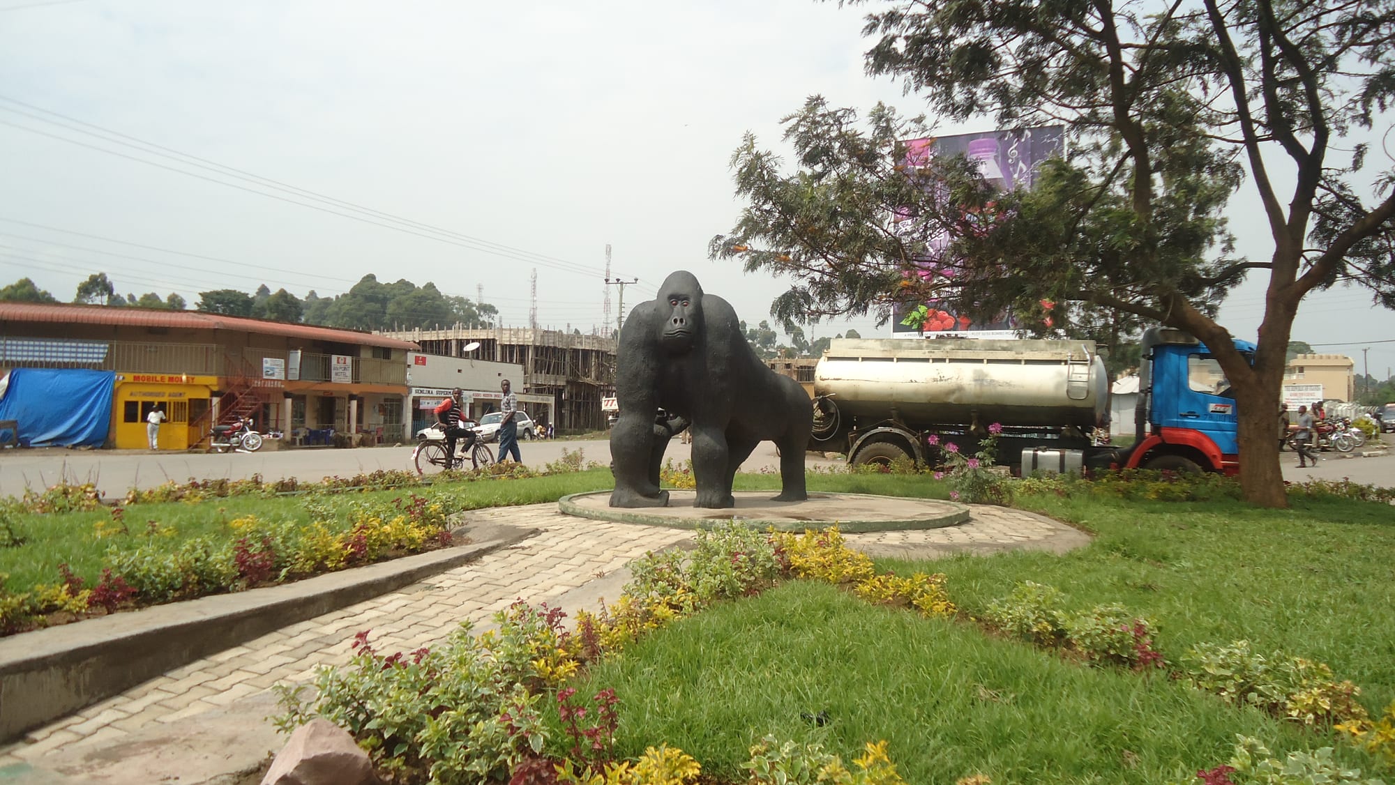
A roadside roundabout in Kisoro with a dark statue of a gorilla on a paved circle, shops and a tanker lorry behind

Bwindi, the Rwenzoris & the West, Uganda

Kisoro

The gorilla statue on a roundabout in the centre of Kisoro, south-western Uganda. (Faintsmoke / Wikimedia Commons · CC BY-SA 4.0)

A small highland town in Uganda's far south-western corner, set on a plateau at about 1,900 metres between the Virunga volcanoes and the lakes of Bufumbira. It is the district headquarters of a densely farmed, Rufumbira-speaking corner of Kigezi, and the usual base for tracking gorillas and golden monkeys in Mgahinga Gorilla National Park.

Neighbourhoods

  • The town centre
    • First-time visitors
    • Budget guesthouses
    • Transport

    A few broad streets of shops, banks, bars and eating houses around the gorilla roundabout, with the bus and shared-taxi stage at one end. Almost everything a visitor needs sits within a ten-minute walk, and the volcanoes fill the view at the end of most streets.

    Open in Maps
  • The Mgahinga road
    • Volcano views
    • Quiet and residential
    • Close to the park

    The southern edge of town, where the streets give way to fields of potatoes and sorghum on the lower slopes of the Virungas. Lodges and guesthouses are scattered along it, and the track to the park gate climbs from here.

    Open in Maps
  • The Mutanda lakeshore
    • Lake views
    • Quiet and residential
    • Walking

    North of the town the plateau drops to Lake Mutanda, an irregular sheet of water dotted with small islands below the volcanoes. A scattering of lakeside camps and farming hamlets lines the shore, reached by rough roads off the Kabale highway.

    Open in Maps

Things to do

In and around the town

  • Lake Mutandaattraction

    An island-studded lake a short drive north of the town, crossed by dugout canoe and motorboat, with the Virunga cones rising behind it.

    Open in Maps
  • Kisoro Airporttransit hub

    The airstrip on the edge of town, used by the small aircraft that shorten the long road journey from Entebbe.

    Open in Maps

Short trips from the town

  • Mgahinga Gorilla National Parkpark

    One of Uganda's smallest national parks, on the Ugandan flanks of the Virunga range about 15 kilometres south, known for golden monkeys, a habituated mountain gorilla group and bamboo forest.

    Open in Maps
  • Mount Muhaburatrail

    The cone that dominates the skyline south-east of Kisoro, at 4,127 metres the highest of the three Virunga peaks on the Ugandan side, climbed in a long, steep day with a ranger.

    Open in Maps
  • Mount Gahingatrail

    The lowest and gentlest of the three Ugandan Virunga volcanoes, with a swampy crater on its summit and a bamboo-lined path up.

    Open in Maps
  • Mount Sabyinyotrail

    A jagged, many-topped volcano whose summit marks the meeting point of Uganda, Rwanda and the Democratic Republic of the Congo.

    Open in Maps
  • Bwindi Impenetrable National Parkpark

    The southern sectors of this UNESCO World Heritage Site, Rushaga and Nkuringo, lie north of Kisoro and hold several habituated mountain gorilla groups in steep montane forest.

    Open in Maps

Eat and drink

Long-standing places and food districts in Kisoro. Hours, ratings and directions come from your maps app, always current.

Markets and eating houses

  • Kisoro central marketmarket

    The town's produce market, piled with Irish potatoes, sorghum, beans, peas, cabbages and bananas brought down from the terraced hills of Bufumbira.

    Open in Maps
  • Eating houses in the town centreneighborhood

    Small local restaurants around the main streets serving plates of matooke, rice, beans, greens and stewed goat or beef, with chapati stands and roadside grills alongside.

    Open in Maps
  • Rolex and chapati stallsneighborhood

    Roadside griddles near the taxi stage turning out the rolex, a chapati rolled around a fried egg with tomato and onion, the standard cheap meal across Uganda.

    Open in Maps

Experience Kisoro

History

The plateau around Kisoro belongs to Bufumbira, the south-western tip of Kigezi, a volcanic country of ash soils and crater lakes that was farmed and grazed long before any border crossed it. Its people, the Bafumbira, speak Rufumbira, a form of Kinyarwanda, and the area's older ties ran south and west to the Rwandan kingdom rather than north to the lake kingdoms of Uganda. Those ties were cut on paper at the turn of the twentieth century, when Anglo-German and Belgian boundary commissions fixed the frontiers of the three colonial territories on the summits of the Virunga volcanoes, leaving Bufumbira inside the Uganda Protectorate.

The British administered the whole of Kigezi from Kabale, and Kisoro grew slowly as a frontier post and market at the end of the road, reached by a route that was not surfaced for decades. Gorillas were already known on the Virunga slopes, protected in a colonial game sanctuary from the 1930s, but the flow of visitors came much later.

The twentieth century brought repeated waves of people across the borders: Rwandans from 1959 onwards, and Congolese during the long unrest in the east. Kisoro had become a district in its own right by the early 1990s, and in 1991 the Ugandan side of the Virungas was gazetted as Mgahinga Gorilla National Park. The Batwa who had lived in that forest were moved out, and the town has since turned steadily towards tourism.

Culture & Customs

Kisoro's culture is the culture of Bufumbira, and it feels closer to Rwanda than to the rest of Uganda. Rufumbira is heard everywhere, in the market and on the radio, and many families have relatives on the other side of the Rwandan frontier. Names, songs, the dance steps performed at weddings, and the hoe-and-terrace farming calendar are all shared across that line.

Christianity is strong, Catholic and Anglican churches and a growing number of Pentecostal congregations filling on Sundays, with a visible Muslim minority around the town's mosque. Life is organised around the church, the clan and the market day, and the exchange of gifts and beer at marriage negotiations still matters.

The Batwa are a distinct and much smaller community. Once hunter-gatherers in the Virunga and Bwindi forests, they were displaced when the parks were created in 1991 and now live on the park margins, among the poorest people in Uganda, campaigning for land and recognition. Several community groups near Kisoro present Batwa history, music and forest skills to visitors, and money from those visits is one of the few local incomes.

Hospitality is formal here: greetings are exchanged at length before any business, elders are served first, and visitors are expected to accept at least something to drink. Photography of people without asking is resented, and the gorilla has become the town's emblem, standing in effigy on its main roundabout.

Daily Life

Kisoro is a small town — roughly 17,500 people at the 2014 census, in a district of several hundred thousand — set in one of the most densely farmed and densely populated corners of Uganda. Almost every slope within sight is terraced and planted, and the fields run to the foot of the volcanoes.

Farming is the living: Irish potatoes above all, which move north by lorry to Kampala, alongside sorghum, beans, peas, maize, wheat and vegetables, with small herds of cattle and goats. Trade is the other pillar. Goods, produce and people move constantly between Uganda, Rwanda and the Democratic Republic of the Congo, and the town's shops, transporters and money changers live off that traffic. A third economy has grown up around the parks — guides, trackers, porters, drivers, lodge staff and craft groups — which is lucrative when trekking is busy and thin when it is not. The area has also served as a reception point for people crossing from eastern Congo during periods of fighting.

Days start cold and early, with the walk to the fields and the boda-bodas warming up on the roundabout; the market fills in the morning, the afternoon brings rain more often than not, and the town is dark and quiet soon after nightfall. Electricity and water supply are improving but unreliable, and land pressure on the terraced hillsides is the district's defining problem.

Food

Kisoro eats like the Kigezi highlands rather than like central Uganda. The Irish potato is king — boiled, mashed or fried, and served with beans or a thin meat sauce at every eating house — and sorghum, peas, beans, maize, cabbage and pumpkin fill out the plate. Matooke, the steamed and mashed green banana of the lowlands, is present but shares the table rather than dominating it.

Millet and sorghum bread, a stiff dark loaf eaten by hand with sauce, is common, as is a groundnut sauce and a dish of beans cooked long and soft. Goat meat grilled over charcoal at the roadside, fried tilapia brought up from the lakes, and small dried fish sold by the cupful in the market are the usual sources of protein; meat is more a weekly than a daily food for most households.

The regional drink is obushera, a fermented sorghum or millet drink taken mildly sweet as a food in itself or left longer to become beer. Banana beer and local waragi are drunk in the town's bars, alongside bottled lagers and sodas. Tea is boiled with milk and ginger, and the market sells beans of the arabica grown on the hills around. Street food runs to chapati, samosas, roasted maize and the rolex.

Planning tools

Budget

The town itself is inexpensive — guesthouse rooms, local meals and shared transport all cost little. The expense is the wildlife: gorilla and golden monkey permits, park entry and a 4x4 with a driver-guide dwarf everything else on a trekking trip, and the smarter lodges around Lake Mutanda and the park gate are priced for that market.

Daily Budget Midrange
USD 180–470 on a trekking itinerary (lodge, park fees, 4x4 and driver-guide), plus permits
Daily Budget Shoestring
USD 25–50 without permits (guesthouse, local food, buses and shared taxis)

Book gorilla and golden monkey permits well ahead for the dry seasons, and confirm which Bwindi or Mgahinga sector a permit is for before choosing where to stay, since the sectors are hours apart by road.

Best Time to Visit

June to August and December to February are the drier spells, when the volcano paths and forest trails are firmer and the roads in from Kabale less slippery. Trekking runs all year, and the wetter months are quieter and greener, but the slopes become hard going and cloud often hides the cones.

Suggested Number of Days

Two days suit a short stay with a single tracking outing. Three to five suit a longer one taking in more of the district. The number depends mostly on how many permits are held and on the long drives in and out of this corner of the country.

First Visit
2 days
With Surroundings
3–5 days

Transportation

The town is small enough to cross on foot. Boda-boda motorbike taxis and shared minibuses handle everything beyond it, and buses run along the main road to Kabale and on towards Kampala. Roads to the park gate, the lake and the Bwindi sectors are unsurfaced, steep in places and slow after rain, so most visitors arrive with a hired 4x4 and a driver-guide.

Allow far more time than the distances suggest on the hill roads, and arrange park transfers through a lodge or operator rather than relying on finding transport in town.

Airport & Station Connections

Kisoro lies at the end of the tarmac road from Kabale, about 80 kilometres of climbing bends away, which is itself some 480 kilometres by road from Kampala — a full day's drive from the capital. Buses run overnight and by day from Kampala, and light aircraft use the airstrip on the edge of town. The borders of Rwanda and the Democratic Republic of the Congo are both within a short drive.

Walkability

The centre is flat, compact and easily walked, with the market, the transport stage, the banks and most guesthouses within a few hundred metres of the roundabout. Beyond the last streets the ground rises and footpaths turn to mud in the rains. The altitude of about 1,900 metres makes uphill walking harder than expected, and nights are cold.

Safety

Kisoro is a quiet district town, and the everyday risks are road accidents on the mountain bends, petty theft in crowds and the cold and altitude on the volcano climbs. The wider area near the border with the Democratic Republic of the Congo carries a real risk from the Allied Democratic Forces, an armed group based in eastern Congo, and security is heavy along the frontier. Parks are entered only with armed rangers and guides.

Uganda is generally safe for tourists on the main routes, with petty theft, road accidents, and boda-boda crashes the everyday risks. Stay informed about the border areas, travel in the parks with an established operator and follow ranger instructions, and carry warm and waterproof clothing for the volcanoes. Check current official travel advice before travelling.

Climate

High, mild and wet. The altitude keeps daytime temperatures moderate all year, typically in the low to mid twenties Celsius, while nights fall close to ten degrees. Rain can come in any month; the wettest spells are roughly March to May and September to November, and mist often sits on the volcanoes in the early morning.

Summer
June to August is the main dry season — warm days around 22–25°C, cold clear nights and the best views of the cones
Winter
December to February is the second drier spell, around 22–25°C by day and near 10°C at night, with showers at either end of it

Local Customs

Most people here are Bafumbira and speak Rufumbira, closely related to Kinyarwanda, alongside English and some Swahili. Greetings come before any request, elders are addressed first, and modest dress is normal in town and in villages. The Batwa, forest hunter-gatherers who lived in Mgahinga and Bwindi until those forests became national parks in 1991, now live on the edges of the parks, and their struggle for land and recognition continues; visits to their communities are best made through established community organisations.

Ask before photographing people, farms or homes, and never photograph border posts, soldiers or police. Tipping guides, trackers and porters is customary. Same-sex relations are criminalised under Ugandan law, and discretion is strongly advised.

Common Payment Methods

The currency is the Ugandan shilling. Park fees, permits and lodge bills are often quoted and paid in US dollars, which should be recent, clean notes. There are banks and ATMs in the centre, but they can run out of cash at weekends, so shillings for markets, boda-bodas and guesthouses are best drawn in Kabale or Kampala. Mobile money is widely used; cards are accepted only at the larger lodges.