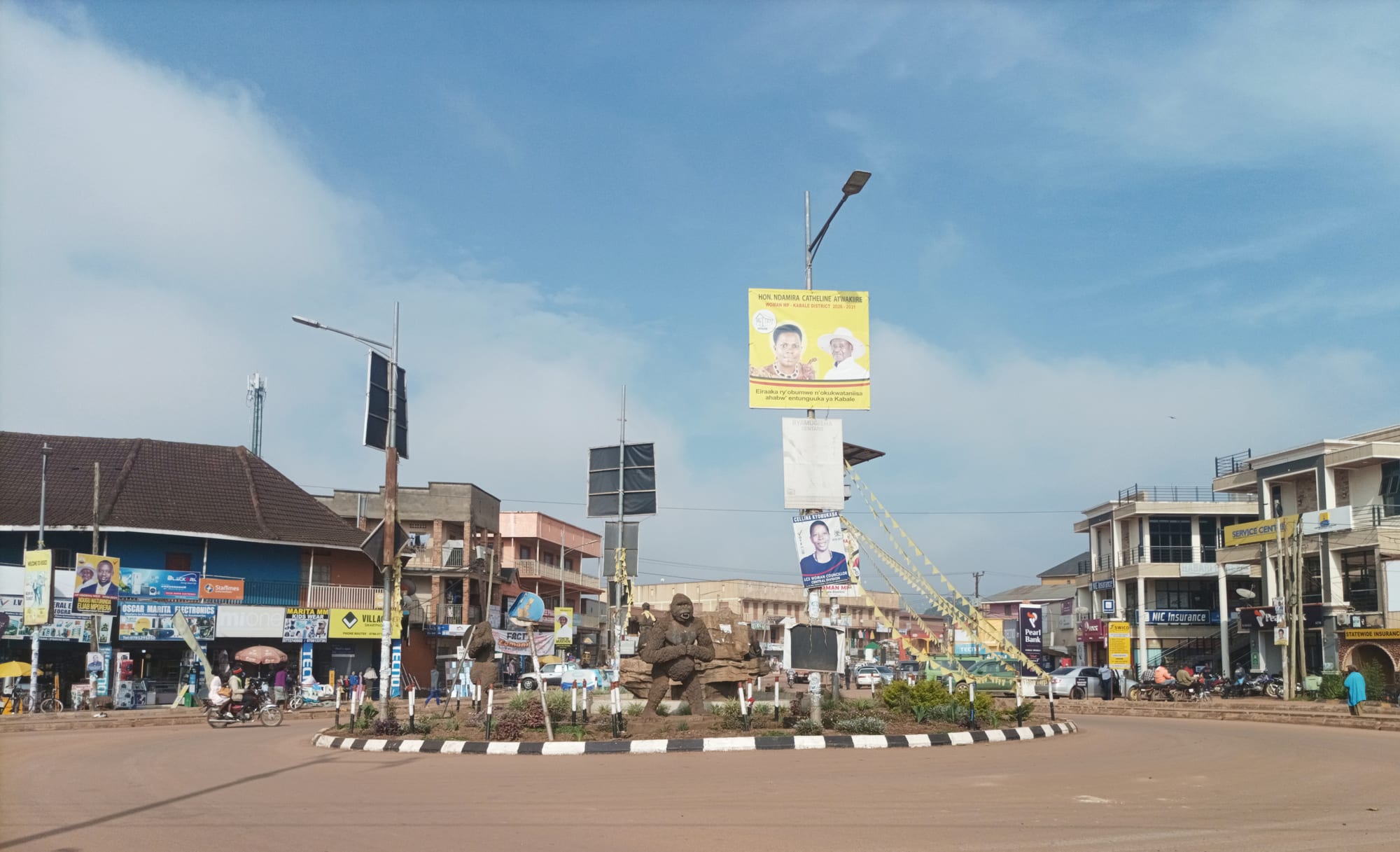
A wide roundabout with a carved gorilla sculpture at its centre, low shopfronts and a motorbike taxi under a blue sky

Bwindi, the Rwenzoris & the West, Uganda

Kabale

The roundabout on the Kabale–Kisoro road in the centre of Kabale, south-western Uganda. (Solomon Suubi / Wikimedia Commons · CC BY-SA 4.0)

A highland town in Uganda's far south-west, in the terraced hills of Kigezi at about 2,000 metres, where nights are genuinely cold. It grew as a colonial administrative station on the road to Rwanda and now lives on farming, trade across the Katuna border and the travellers who come for Lake Bunyonyi and the gorilla forests beyond.

Neighbourhoods

  • Town centre
    • First-time visitors
    • Buses and shared taxis
    • Markets

    A few long streets of shops, banks, hardware stores and eating houses either side of the main road that runs on to Kisoro and to the Rwandan border. Almost everything in Kabale — the market, the bus stages, the boda-boda ranks — is within a short walk of it.

    Open in Maps
  • Rushoroza and the hills above town
    • Views
    • Quiet and residential
    • Churches

    Kabale sits in a bowl, and the residential lanes climb the slopes on every side to churches, schools and compounds of red-earth gardens. The climb is steep, and the reward is a view over the tin roofs of the centre to the terraced ridges beyond.

    Open in Maps
  • Kikungiri and the university side
    • Students
    • Quiet and residential

    The south-eastern edge of town, where Kabale University and several colleges have drawn student hostels, small restaurants and photocopy shops on to what were farm plots. It is quieter than the centre and close to the Bunyonyi road.

    Open in Maps
  • The Lake Bunyonyi shore
    • Rest days
    • Swimming and boats
    • Views

    About eight kilometres from town over a steep ridge, the lakeshore and its islands hold most of the area's guesthouses and campsites. Days there run on boats, swimming and walking the terraces rather than on anything in the town itself.

    Open in Maps

Things to do

Lakes and hills

  • Lake Bunyonyiattraction

    A deep, irregular lake of 29 islands about eight kilometres west of town, ringed by terraced hills, reached by dugout or motorboat; one small island, Akampene, is remembered as the place where unmarried pregnant girls were once abandoned.

    Open in Maps
  • Echuya Forest Reservepark

    A high bamboo and montane forest reserve on the ridge towards Kisoro, known for birds and for the Batwa communities living on its edges.

    Open in Maps
  • Kabale Universityattraction

    A public university on the south-eastern edge of town, founded as a private institution in 2002 and taken on by the state in 2015, and the biggest thing in Kabale after the market.

    Open in Maps

Short trips from the town

  • Bwindi Impenetrable National Parkpark

    The UNESCO-listed montane forest that holds about half the world's mountain gorillas; its Ruhija sector, west of Kabale, is the closest of the four tracking sectors.

    Open in Maps
  • Mgahinga Gorilla National Parkpark

    One of Uganda's smallest national parks, on the flanks of the Virunga volcanoes beyond Kisoro, with golden monkeys, bamboo forest and volcano climbs.

    Open in Maps
  • Lake Mutandaattraction

    A quieter island-scattered lake below the Virunga cones near Kisoro, crossed by canoe with the volcanoes filling the skyline.

    Open in Maps
  • Mount Muhaburatrail

    At 4,127 metres the highest of the three Virunga peaks on the Ugandan side, a long, steep climb made with a ranger from the Mgahinga side.

    Open in Maps

Eat and drink

Long-standing places and food districts in Kabale. Hours, ratings and directions come from your maps app, always current.

Markets and food streets

  • Kabale central marketmarket

    The town's produce market, piled with Irish potatoes, sorghum, beans, peas, cabbages and passion fruit from the surrounding terraces, and the place to see what Kigezi actually grows.

    Open in Maps
  • Eating houses in the town centreneighborhood

    Plain local restaurants along the main street serve the standard plate of matooke, Irish potatoes, beans, greens and a meat or groundnut sauce, with chapatis and rolex stands working from the pavement.

    Open in Maps
  • Guesthouse kitchens on Lake Bunyonyineighborhood

    The lakeshore campsites and guesthouses cook for their own guests, and crayfish, introduced to the lake, turns up on their menus more often than in town.

    Open in Maps

Experience Kabale

History

The Kigezi highlands were farmed and grazed for centuries by Bakiga clans living without kings, in scattered homesteads on ridges they terraced by hand. The British reached the area late: a station was established at Kabale early in the twentieth century, after boundary commissions had divided the highlands between the British, German and Belgian spheres, leaving related communities on either side of new lines towards Rwanda and the Congo. The town that grew around the station became the administrative centre of Kigezi district, with a hospital, mission schools and the offices of a colonial government that treated the district as a labour reserve.

Population pressure shaped everything that followed. The hills were among the most densely settled in East Africa, and the administration resettled thousands of families northwards into less crowded country in present-day Ankole and beyond, a movement that spread Bakiga farmers across western Uganda. Kabale remained a small, cool upcountry town of tin roofs and eucalyptus, remembered by colonial officials as a place to escape the heat.

Independence brought the upheavals of the wider country, and the town's position near two borders made it a transit point during the region's later crises, including the movement of refugees to and from Rwanda and the Congo. The tourist economy arrived with the gazetting of Bwindi and Mgahinga as national parks in 1991 and the growth of gorilla tracking, which turned a market town on the Kigali road into the gateway that travellers now pass through.

Culture & Customs

Kabale is the main town of the Bakiga, whose language, Rukiga, is heard everywhere in the market and on the buses. The Bakiga are known across Uganda for a reputation as hard workers on difficult ground — the terraced hillsides around the town are the evidence — and for the vigorous stamping dances, the ekizino above all, performed at weddings and gatherings, in which lines of dancers drive their heels into the ground to the beat of drums. Sorghum beer and millet drinks have long accompanied these occasions.

Clan and family ties remain strong, and marriage negotiations, burials and church events fill weekends. Christianity is deeply rooted here, Anglican and Catholic in roughly equal measure, with cathedrals and mission schools on the hills above town and congregations that spill out into the open on Sunday mornings. The East African Revival of the 1930s, which spread through the churches of this borderland, left a strong evangelical strain that persists.

The Batwa, forest hunter-gatherers who lived in Echuya, Bwindi and Mgahinga until those forests became protected areas, now live in settlements on their edges, and their loss of land and continued marginalisation is an open issue in the district. Cultural visits run by Batwa groups have become part of the local tourist economy. Kabale's other cultural marker is simpler: the cold. Sweaters, blankets and hot tea are part of daily life in a way they are not in most of Uganda.

Daily Life

About 50,000 people lived in Kabale at the 2014 census, in a town that spreads up the slopes of its bowl and along the highway. The economy is farming and trade: Irish potatoes above all, along with sorghum, beans, peas, wheat, vegetables and passion fruit grown on terraces that climb to the ridge tops. Lorries take produce north to Mbarara and Kampala, and traders move goods south through the Katuna crossing, which ties the town's fortunes to relations with Rwanda. When those relations deteriorated in February 2019, Rwanda closed its borders with Uganda; the crossing at Katuna is now open around the clock.

The university and the colleges have added a student population, hostels and small businesses on the eastern side, and the hospital and district offices are significant employers. Tourism supports drivers, guides, boat owners and lakeside camps, though much of the money that gorilla tracking brings to the region is spent in the parks rather than in the town.

Days start early and cold, with mist in the valley, and the market is busiest in the morning. Land is the recurring issue: holdings divided between children have grown tiny, soils on the steep slopes erode, and young people leave for Kampala or for farms in the resettlement districts to the north. Firewood and eucalyptus plantations, water, and the price of potatoes are the everyday concerns.

Food

Kigezi eats differently from much of Uganda. Irish potatoes, introduced in the colonial period and suited to the cool, high ground, are the staple here as much as matooke, boiled and served with beans or a sauce, and sorghum and millet are ground into kalo, a stiff dark bread eaten with the fingers. Beans and peas from the terraces are cooked slowly and heavily; groundnut sauce, greens and, on better days, goat or beef fill out the plate.

The characteristic drink is obushera, made from fermented sorghum or millet flour, taken mildly sweet and thin as an everyday drink or left to ferment into a beer for celebrations. Sorghum beer is still brewed at home in the villages, and tea with milk and ginger is drunk all day against the cold. Local honey and passion-fruit juice appear on guesthouse tables.

Lake Bunyonyi had no fish of its own and was stocked with introduced species, so tilapia, catfish and crayfish from the lake are a relatively recent local speciality, usually eaten at the lakeside camps rather than in town. In the centre, the eating is plain and cheap: chapati and fried eggs rolled together as a rolex, samosas, grilled meat from roadside braziers, roasted maize, and buffet plates of matooke, rice, potatoes and stew served at midday.

Planning tools

Budget

Kabale itself is one of the cheaper towns in Uganda: guesthouses, market food and shared transport all cost little, and Lake Bunyonyi has good-value campsites and bandas alongside a few smarter lodges. Costs jump only when the town is used as a base for the parks, where permits, park fees and a 4x4 with a driver-guide dominate the bill.

Daily Budget Midrange
USD 180–470 on a trekking itinerary (lodge, park fees, 4x4 and driver-guide), plus permits
Daily Budget Shoestring
USD 25–45 (guesthouse or lakeside banda, local meals, buses and shared taxis)

Set aside the big money for permits and transport and keep the town days cheap; boat hire on Lake Bunyonyi and shared taxis to the lake are arranged locally.

Best Time to Visit

June to August and December to February, the two drier spells, are the easiest months, with firmer forest trails for gorilla tracking and better roads into Bwindi. The hills stay green all year and the lake is at its calmest in the early morning; the wetter months bring mist, mud and fewer visitors.

Suggested Number of Days

The town itself is seen in a morning, and most stays run to one or two days. Three or four suit anyone using it as a base for the lakes, the terraces and the forests further west, and long transfer times on slow roads are the main thing that stretches a visit.

First Visit
1–2 days
With Surroundings
3–4 days

Transportation

Everything in the centre is walkable, and boda-boda motorbike taxis and shared taxis cover the hills and the road down to Lake Bunyonyi. Buses and coasters run through the town on the Kampala–Kisoro highway, and shared taxis work the short hop to the Katuna border. Visitors heading into Bwindi or the Virungas almost always travel by hired 4x4 with a driver.

Agree a fare before taking a boda-boda, and allow far longer than the distance suggests on the dirt roads west of town, which are steep and slow in rain.

Airport & Station Connections

Kabale lies on the paved highway from Kampala to Kisoro, roughly 400 kilometres from the capital and most of a day by road; buses and coasters run through daily. The Katuna border crossing into Rwanda is about 28 kilometres south, which makes the town a common first or last stop on the overland route to and from Kigali. The nearest airstrips for light aircraft from Entebbe are at Kisoro and Kihihi.

Walkability

The centre is small, flat along its main street and easily covered on foot, with the market, the bus stages and the shops within a few hundred metres of each other. Away from that strip the ground rises sharply in every direction, and the residential lanes are steep, unpaved and slippery after rain. The lake is too far and too hilly to walk to comfortably.

Safety

Uganda is generally safe for tourists on the main routes, with petty theft, road accidents, and boda-boda crashes the everyday risks. Kabale is a quiet market town and the everyday concerns are much the same: traffic on the highway through the centre, motorbike taxis, and opportunistic theft in crowds at the market or the bus stages. Nights at this altitude are cold, and the lake is deep, with no lifeguards and boats of varying quality.

Keep valuables out of sight around the bus stages, avoid riding boda-bodas at night, take a life jacket on the lake and ask about conditions on the border roads to the west before travelling. Check current official travel advice before travelling.

Climate

At about 2,000 metres Kabale is one of the coolest towns in Uganda, mild by day and cold after dark, with frost recorded in the surrounding hills. Rain falls in most months, heaviest around March to May and September to November, and mist often sits in the valleys in the early morning.

Summer
June to August is the main dry spell, with days around 22–24°C and cold, clear nights
Winter
December to February is the second drier period, around 22°C by day, with nights near 10°C and colder on the ridges

Local Customs

This is Bakiga country, and the local language is Rukiga, close to the Runyankore spoken further north; English is used in offices and with visitors. Greetings come before business, and elders are greeted first. Churches are full on Sundays and dress in town is modest. The Batwa, who lived in the forests before they became national parks, run cultural visits near Echuya and Bwindi, and these are best arranged through the community groups themselves.

Ask before photographing people, markets or homes, dress modestly away from lakeside camps, and be aware that the Anti-Homosexuality Act, 2023 prescribes severe penalties for same-sex acts nationwide.

Common Payment Methods

The currency is the Ugandan shilling. Banks and ATMs are on the main street in the centre, and they are the last reliable ones before Kisoro and the forests, so cash is usually drawn here. Cards are accepted only by a few lodges; markets, boats, boda-bodas and small guesthouses want cash, and mobile money is widely used. Park fees and permits are quoted in US dollars and settled in advance.