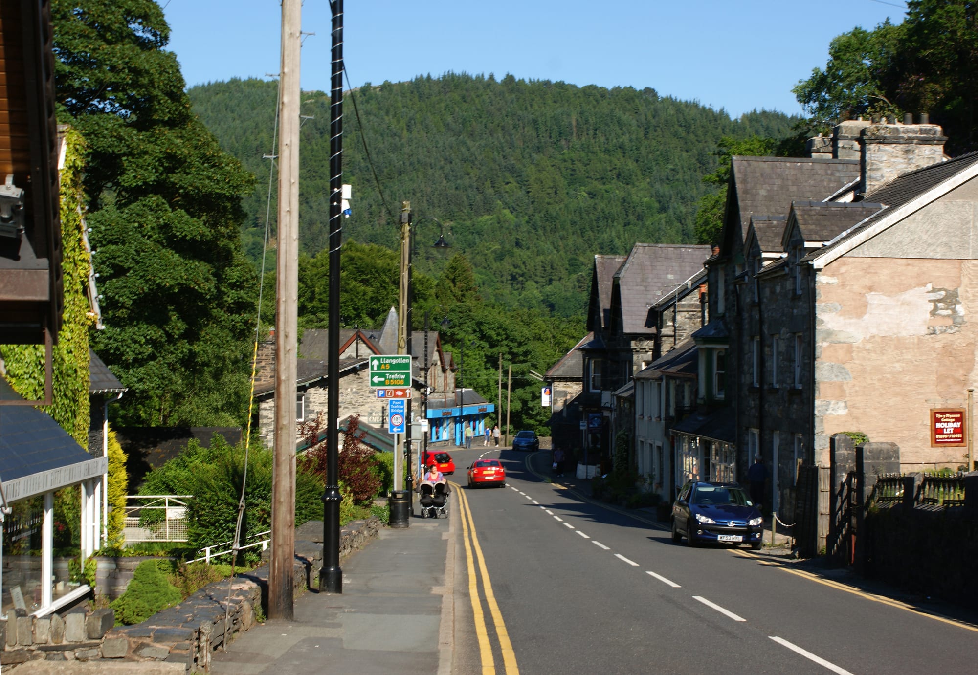
A village street of grey stone houses with slate roofs curving towards a steep hillside covered in dark conifer forest

Wales, United Kingdom

Betws-y-Coed

The main road through Betws-y-Coed, beneath the forested slopes of the Conwy valley. (Ian Greig / Wikimedia Commons · CC BY-SA 2.0)

A stone village in the wooded valley where the Llugwy and Lledr meet the River Conwy, on the eastern edge of Eryri (Snowdonia). A farming hamlet until Telford's road and the railway arrived in the 19th century, it drew landscape artists and early tourists, and today it is a centre for outdoor activities in the national park.

Neighbourhoods

  • The village centre
    • First-time visitors
    • Close to public transport

    The stretch of the A5 through the village, with its stone buildings, outdoor-gear shops, cafés and pubs and the railway station, whose former goods yard holds a small railway museum. Most visitors stay and eat here, within a short walk of the rivers.

    Open in Maps
  • Pont-y-Pair and the Llugwy
    • Walks
    • Riverside

    The old stone bridge over the rocky River Llugwy in the village, with a forest boardwalk just beyond it and riverside paths leading into the woods.

    Open in Maps
  • The Conwy riverside
    • Quiet and residential
    • Historic sights

    The quieter side of the village along the River Conwy, with the medieval St Michael's Church and Telford's cast-iron Waterloo Bridge.

    Open in Maps

Things to do

In the village

  • Pont-y-Pair Bridgelandmark

    The stone bridge, first built in the 15th century, carrying the road over the rapids of the River Llugwy in the village.

    Open in Maps
  • Waterloo Bridgelandmark

    Thomas Telford's cast-iron bridge of 1815, which carried the Irish Mail road — today's A5 — across the River Conwy.

    Open in Maps
  • St Michael's Churchlandmark

    The old church north-east of the village whose oldest parts date from the 14th or 15th century, and from which the village took the name Betws.

    Open in Maps
  • St Mary's Churchlandmark

    The parish church designed by Paley and Austin and consecrated in 1873, built to hold the growing numbers of summer visitors.

    Open in Maps

Waterfalls and forest

  • Swallow Fallsviewpoint

    A series of waterfalls on the River Llugwy about 2 miles west of the village on the road to Capel Curig.

    Open in Maps
  • Conwy Fallsviewpoint

    A waterfall on the River Conwy at Bro Garmon, south of the village near the A5; the falls and their surroundings are a Site of Special Scientific Interest.

    Open in Maps
  • Gwydir Forestpark

    The forest in which the village lies, crossed by wide tracks, old miners' paths, waymarked forest walks and the Marin Trail mountain-bike route.

    Open in Maps
  • Tŷ Hyllattraction

    The 'Ugly House', a crudely built stone house on the A5 between Betws-y-Coed and Capel Curig, bought and restored by the Snowdonia Society from 1988.

    Open in Maps

Short trips from the village

  • Dolwyddelan Castlelandmark

    A castle of the princes of Gwynedd in the Lledr valley, probably begun by Llywelyn ab Iorwerth, about 5 miles south-west of the village.

    Open in Maps
  • Gwydir Castlelandmark

    A fortified manor house in the Conwy valley, seat of the Wynn family by the 16th century, a mile west of the market town of Llanrwst.

    Open in Maps
  • Snowdon Mountain Railwayattraction

    The rack railway from Llanberis to the summit of Yr Wyddfa (Snowdon), the highest mountain in Wales, reached from the village by the Sherpa bus.

    Open in Maps
  • Llechwedd Slate Cavernsattraction

    A visitor attraction in the Llechwedd slate quarry near Blaenau Ffestiniog, the town at the end of the Conwy Valley line, with a deep mine tour on a steep underground railway.

    Open in Maps

Eat and drink

Long-standing places and food districts in Betws-y-Coed. Hours, ratings and directions come from your maps app, always current.

Village food

  • Cafés and pubs on the A5neighborhood

    Tea rooms, cafés and pubs along the main road through the village; most places serve classic Welsh food or a bar menu.

    Open in Maps
  • Llanrwstneighborhood

    The market town a few miles down the Conwy valley, with more everyday shops, cafés and pubs.

    Open in Maps

Experience Betws-y-Coed

History

The name means "prayer-house in the woods". St Michael's Church, to the north-east of the village, has parts dating from the 14th or 15th century, and the village stands near where the Llugwy and the Lledr join the River Conwy. For most of its history Betws-y-Coed was a small farming community in a deep, wooded valley.

Change came in the 19th century. A lead mining industry developed in the hills, and in 1815 Thomas Telford's Waterloo Bridge opened to carry the London to Holyhead road — the Irish Mail route and today's A5 — across the Conwy and through the village. The Conwy Valley line arrived from Llanrwst in the 1860s, and with it the population grew by around 500. The new transport links brought visitors and landscape artists drawn by the rivers and woods, and the village built for them: St Mary's Church, designed by Paley and Austin and consecrated in 1873, replaced the old church because it could not hold the summer crowds. Bryn Mawr chapel, built in 1808 for the Calvinistic Methodists and rebuilt in 1872, still serves the Presbyterian Church of Wales.

The village now lies within Gwydir Forest and inside Snowdonia National Park. The forest is crossed by waymarked walks, old miners' paths and a competition-standard mountain-bike route, and Betws-y-Coed has become a centre for outdoor activities in Eryri.

Culture & Customs

Betws-y-Coed has been a visitors' village for more than 150 years, and it still feels like one: the main street is lined with outdoor shops, tea rooms and pubs, and walkers, climbers and mountain bikers fill it at weekends. The station was built of local materials by the local builder Owen Gethin Jones, and the Conwy Valley Railway Museum occupies its former goods yard.

The village's artistic past is part of its identity. In the 19th century it became popular with landscape painters, drawn by the river and woodland scenery that still brings visitors today. Its two churches, the medieval St Michael's and the Victorian St Mary's, tell the story of the change from farming hamlet to resort.

Welsh is spoken alongside English: at the 2021 census about a quarter of the residents of Conwy County Borough said they could speak it. The village's name itself is Welsh, from betws, a prayer-house, and y coed, the wood.

Daily Life

Betws-y-Coed is tiny: the community had 476 people at the 2021 census, fewer than ten years earlier, and its electoral ward, which also takes in the neighbouring communities of Capel Curig and Dolwyddelan, about 1,250. The ward elects a county councillor to Conwy County Borough Council.

Much of the village serves visitors, from guest houses, cafés and pubs to outdoor-gear shops and the activities of the forest around it. Llanrwst, the market town down the valley, is the nearest larger town, and the coast is reached by the A470 or the Conwy Valley line, which has six trains a day each way from Monday to Saturday and four on Sundays.

The seasons set the rhythm. In summer the main street and car parks are crowded and the falls and trails busy, and in winter the village is quiet. Bus travel is patchy: many buses run only on certain days or in certain periods, and on Sundays there are almost no buses except the S2.

Food

Food in Betws-y-Coed is mostly the food of walkers: cafés, tea rooms and pubs along the main road serving hearty meals and cakes. The dishes to look for are the Welsh classics. Cawl, recognised as a national dish of Wales, is a broth of lamb or beef with leeks, potatoes and root vegetables; Welsh rarebit is a hot cheese sauce, often with ale or mustard, on toast; and Glamorgan sausages are vegetarian, made mainly from cheese, usually Caerphilly, with leeks and breadcrumbs.

Teatime baking is a strength of Welsh cafés. Welsh cakes, or picau ar y maen, are small spiced fruit cakes cooked on a bakestone or griddle, and bara brith is a fruit loaf made with tea-soaked dried fruit.

The village has relatively few restaurants, and most serve classic Welsh food or a bar menu. Welsh beef is registered as a Protected Geographical Indication. For a wider choice of shops and restaurants, the market town of Llanrwst lies a few miles down the Conwy valley.

Planning tools

Budget

Rooms in and around the village are in demand from spring to autumn and in the summer holidays, when prices climb, and choice is limited for a place of its size. Walking the forest and riverside paths is free; a car or the buses and the Conwy Valley line are needed to reach the mountains, castles and slate country around it.

Daily Budget Midrange
USD 160–300 (B&B or guest house, pub and restaurant dinners, castle tickets, a hire car)
Daily Budget Shoestring
USD 65–110 (hostel or campsite, café and pub meals, buses and the Conwy Valley line)

The S2 Sherpa bus reaches Swallow Falls, Capel Curig and, for the Snowdon Mountain Railway, Llanberis.

Best Time to Visit

May to September for walking, cycling and the waterfalls with the woods in full leaf; July and August are busiest. Autumn brings colour to the valley's woods and fewer crowds, and the falls are at their most powerful after heavy rain. In winter the village is quiet and the high mountains can be snowbound.

Suggested Number of Days

The village, its riverside walks and the nearby falls fill a day or two. As a base for Eryri, four to six days allow for mountain walks and the valleys around; days lost to the weather in the mountains are common, so a spare day helps.

First Visit
1–2 days
With Surroundings
4–6 days

Transportation

The village is small enough to walk. The Conwy Valley line has six trains a day each way from Monday to Saturday between Llandudno and Blaenau Ffestiniog, and the S2 Sherpa bus runs to Capel Curig and on towards Llanberis, with local buses down the valley to Llanrwst. Many visitors come by car, though parking in the village fills on busy days.

Most built-up roads in Wales have a 20 mph limit, and the mountain roads beyond the village are narrow and winding.

Airport & Station Connections

By rail, Betws-y-Coed station is on the Conwy Valley line from Llandudno Junction on the North Wales coast, where main-line trains arrive from across the UK, including London Euston. By road, the A5 runs through the village from Llangollen and the English border, and the A470 comes up the Conwy valley from the coast.

Walkability

The village centre is compact and easy on foot, with riverside paths, a forest boardwalk and marked forest trails leading straight out into the woods. The A5 through the village is busy with traffic in summer, and walks to the falls and into the hills involve steep, rough or muddy ground.

Safety

The UK is generally safe, with the main risks being pickpocketing and phone theft in crowded parts of London and other cities, occasional late-night antisocial behaviour, and drink-related trouble around nightlife. In Betws-y-Coed the real dangers are outdoors: in winter conditions the mountain routes of Eryri become significantly more dangerous.

Walk the mountains with proper boots, map and waterproofs, and keep back from the rocks at Pont-y-Pair and the falls. Check current official travel advice before travelling.

Climate

Wet and changeable. The mountains of Eryri are among the wettest parts of the UK. In nearby Capel Curig the highest temperature recorded is 32.1°C, on 19 July 2022.

Summer
warm and often sunny at low elevations in Wales, with average maximum temperatures of about 19–22°C; cooler on the mountains
Winter
fairly wet across Wales, with temperatures at low levels usually staying above freezing (0°C); the higher parts of Eryri average only about 5°C over the whole year

Local Customs

About a quarter of the people of Conwy County Borough can speak Welsh, and the village's name means 'prayer-house in the wood'. Walkers in boots are normal in pubs and cafés, but muddy gear is best left at the door. Tipping is not a strong custom in Britain; something extra for good service is welcome but not expected.

Footpaths cross working sheep farms: gates are left as found and dogs kept on leads near livestock.

Common Payment Methods

The currency is the pound sterling. Many shops accept foreign credit and debit cards, and cash machines are very widely available in Britain; some businesses no longer accept cash.