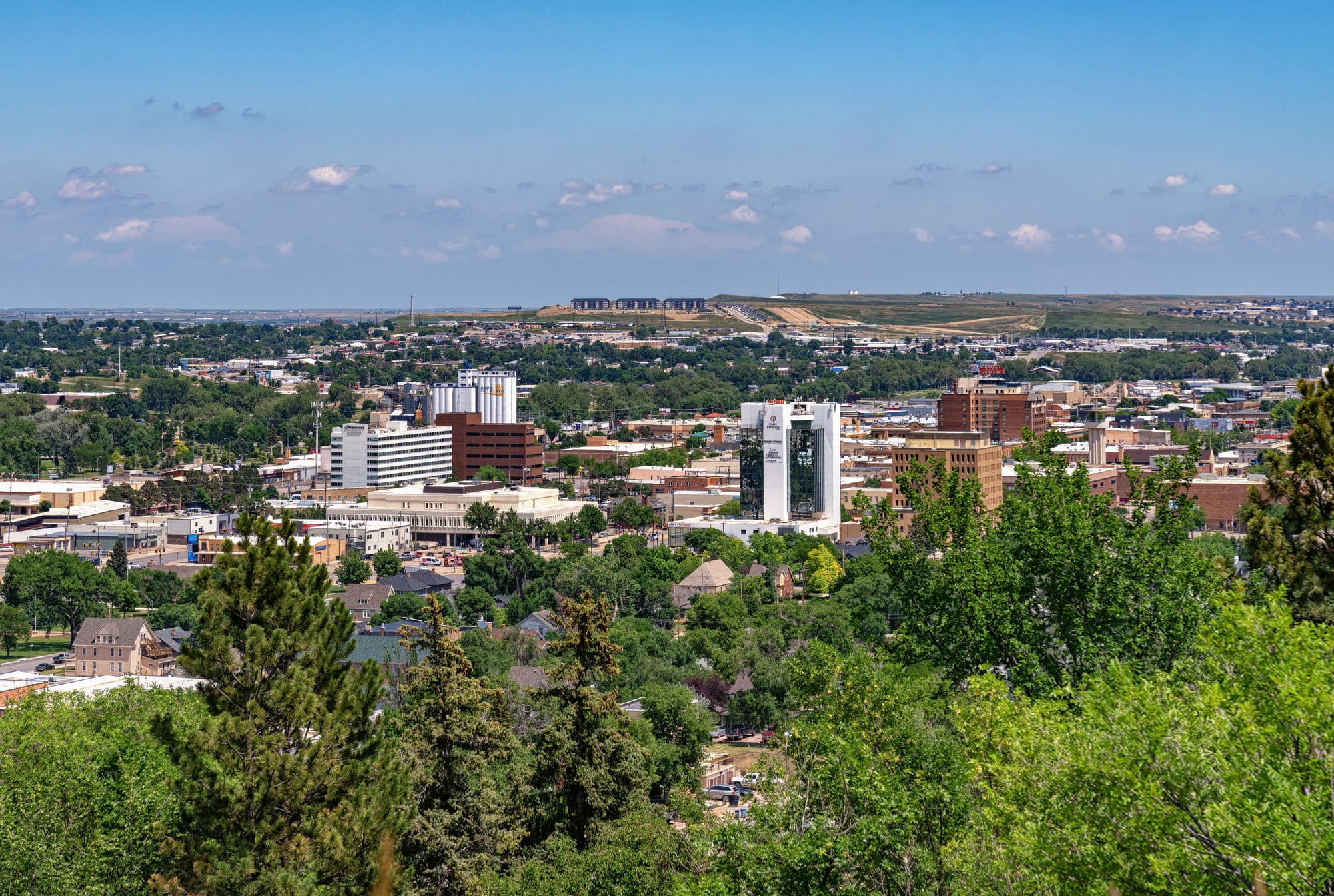
Downtown Rapid City's low office towers rising above green treetops, with flat plains stretching to the horizon

The Great Plains, United States

Rapid City

Downtown Rapid City seen from Dinosaur Park on the ridge west of the centre. (Tony Webster / Wikimedia Commons · CC BY-SA 2.0)

South Dakota's second-largest city, on the eastern edge of the Black Hills where Rapid Creek leaves the mountains. Founded in 1876 during the Black Hills gold rush, it grew as a rail, trade and military town, and since the carving of Mount Rushmore has been the main base for visitors to the Black Hills and the Badlands.

Neighbourhoods

  • Downtown
    • First-time visitors
    • Best for food
    • Historic district

    The original grid laid out in 1876, east of the ridge known as the Gap. Brick commercial blocks, the bronze presidents on the street corners, Art Alley, Main Street Square and most of the city's bars, breweries and restaurants are within a few blocks of each other, with the Rapid Creek parks along the northern edge.

    Open in Maps
  • Westside
    • Quiet and residential
    • Close to the Black Hills

    The part of the city in the Red Valley between the Dakota Hogback ridge and the foothills of the Black Hills, named for its red soils. It is mostly houses and streets climbing into the hills, with Canyon Lake and the upper reaches of the Rapid Creek parks.

    Open in Maps
  • North Rapid
    • Close to Interstate 90
    • Shopping

    The newer commercial area on the city's north edge near Interstate 90, around the Uptown Rapid shopping mall, formerly the Rushmore Mall. Convenient for drivers rather than for walking.

    Open in Maps

Things to do

Downtown and the ridge

  • City of Presidentsattraction

    A series of life-size bronze statues of former presidents of the United States, standing on street corners across downtown, which gives the city one of its nicknames.

    Open in Maps
  • Art Alleyattraction

    A downtown alley whose walls are covered in graffiti, paintings and poetry, repainted constantly by local artists with the building owners' permission.

    Open in Maps
  • Dinosaur Parkpark

    Seven concrete dinosaur sculptures on a hill overlooking the city, built by the Works Progress Administration and dedicated in 1936, with free entry and a wide view of downtown and the plains.

    Open in Maps
  • Chapel in the Hillslandmark

    A stave church near the city, dedicated in 1969 as an exact replica of the Borgund stave church in Norway.

    Open in Maps

Museums

  • The Journey Museum and Learning Centermuseum

    A museum set up as a journey through the history of the Black Hills, from Lakota creation stories through geology, palaeontology and archaeology to the settlers, with a display on the 1972 flood.

    Open in Maps
  • Museum of Geologymuseum

    The South Dakota School of Mines and Technology's museum of fossils, minerals and rocks, many of them from South Dakota.

    Open in Maps
  • South Dakota Air and Space Museummuseum

    An aviation museum just outside the main gate of Ellsworth Air Force Base, east of the city, on the history of the Air Force, the base and aerospace in South Dakota.

    Open in Maps

Parks and wildlife

  • Storybook Islandpark

    A free children's park beside Rapid Creek, founded in 1959; most of its play areas were washed away by the 1972 flood and rebuilt.

    Open in Maps
  • Rapid Creek parks and bike pathspark

    The floodplain cleared after the 1972 flood, now a chain of parks, arboretums, golf courses and bike paths following the creek through the city.

    Open in Maps
  • Reptile Gardensattraction

    A reptile zoo on the road south towards Mount Rushmore, certified by Guinness World Records as the world's largest reptile zoo.

    Open in Maps
  • Bear Country USAattraction

    A drive-through wildlife park founded in 1972, with bears, wolves, elk, mountain lions and bison in large enclosures and a walking area for young animals.

    Open in Maps

Sport and events

  • The Monumentattraction

    The city's large event centre, formerly the Rushmore Plaza Civic Center, home to the Rapid City Rush ice hockey team and to the Black Hills Stock Show and Rodeo.

    Open in Maps

Short trips from the city

  • Mount Rushmore National Memoriallandmark

    The heads of Washington, Jefferson, Theodore Roosevelt and Lincoln, each 60 feet tall, carved into granite between 1927 and 1941 on a mountain the Lakota call the Six Grandfathers.

    Open in Maps
  • Crazy Horse Memoriallandmark

    A mountain carving of the Oglala Lakota leader Crazy Horse on horseback, commissioned by the Lakota elder Henry Standing Bear, in progress since 1948 and far from complete.

    Open in Maps
  • Custer State Parkpark

    South Dakota's first and largest state park, more than 71,000 acres of prairie and mountains with a herd of about 1,400 bison, the Needles Highway and a wildlife loop road.

    Open in Maps
  • Wind Cave National Parkpark

    Established in 1903 as the first cave anywhere to be made a national park, known for its boxwork calcite formations, with bison on the prairie above.

    Open in Maps
  • Badlands National Parkpark

    Sharply eroded buttes and pinnacles and the largest undisturbed mixed-grass prairie in the United States, east of the city; the South Unit is co-managed with the Oglala Lakota.

    Open in Maps
  • Deadwoodattraction

    A gold-rush town of 1876 in a gulch in the northern Black Hills, designated in full as a National Historic Landmark District, with five history museums.

    Open in Maps

Seasonal events

  • Lakota Nation Invitationalwinter

    A multi-sport tournament at The Monument for around 40 schools from reservations in four states, with basketball alongside traditional Lakota hand games and a language bowl.

  • Sturgis Motorcycle Rallyearly August

    A ten-day motorcycle rally in nearby Sturgis, held since 1938, which fills Rapid City's hotels and roads with hundreds of thousands of riders.

Eat and drink

Long-standing places and food districts in Rapid City. Hours, ratings and directions come from your maps app, always current.

South Dakota classics

  • Chislicrestaurant

    Deep-fried cubes of mutton, lamb, beef or venison sprinkled with garlic salt and served on toothpicks with soda crackers — South Dakota's official state 'nosh' since 2018.

    Open in Maps
  • Frybread and Indian tacosrestaurant

    Frybread, the official state bread of South Dakota since 2005, is eaten plain or with toppings such as honey or powdered sugar, and is the base of the Indian taco.

    Open in Maps
  • Kuchencafe

    A German-style custard and fruit tart brought by settlers of German heritage, named the official state dessert in 2000.

    Open in Maps

Food districts and bars

  • Firehouse Brewing Companyrestaurant

    A brewery and restaurant in the old downtown fire station, with a summer patio.

    Open in Maps
  • Downtown Main Streetneighborhood

    The blocks around Main Street and Main Street Square hold most of the city's independent restaurants, coffee shops, ice cream parlours and bars.

    Open in Maps

Experience Rapid City

History

The Black Hills were Lakota land, guaranteed to the Sioux by treaty, when an army expedition led by George Armstrong Custer made public the discovery of gold in 1874 and miners and settlers poured in. Rapid City was laid out in February 1876 by John Richard Brennan, Samuel Scott and a small group of men, among them miners who had failed to strike it rich. First known as Hay Camp, it took its name from Rapid Creek and promoted itself as the "Gateway to the Black Hills", selling supplies to miners and pioneers. Railroads from the south and east arrived in the late 1880s, and by 1900 the town had survived a boom and bust to become a regional trade centre.

Tourism took off in the 20th century. President Calvin Coolidge spent the summer of 1927 in the Black Hills and announced from his summer office in Rapid City that he would not run again; that same year Gutzon Borglum began carving Mount Rushmore, and in 1936 the city opened Dinosaur Park to catch the visitors. The Second World War brought an army air base, later Ellsworth Air Force Base, and the population nearly doubled between 1940 and 1948. During the Cold War Minuteman missile silos were scattered across the plains around the city.

On 9 June 1972 heavy rain sent a flash flood down Rapid Creek through the city, killing 238 people and destroying or making uninhabitable more than 1,300 homes; a mainly Native American neighbourhood was among the worst hit. The city cleared the floodplain and turned it into parks. In 1980 the Supreme Court ruled that the Sioux had not been justly compensated for the Black Hills; the Lakota refused the money and still seek the return of the land, which includes Rapid City.

Culture & Customs

The city's identity is built on its role as the gateway to the Black Hills, and it leans into the presidential theme of Mount Rushmore: bronze statues of former presidents stand on downtown street corners, giving Rapid City its other nickname, the "City of Presidents". Downtown's Art Alley, whose walls are repainted constantly with graffiti, murals and poetry, is a gathering place for young locals, and the Journey Museum tells the story of the Black Hills from Lakota creation stories onward.

Native Americans make up a significant part of the population — about 12 per cent at the 2010 census — and Lakota culture is visible in events such as the Lakota Nation Invitational, held each winter, where schools from reservations across four states compete in basketball, traditional hand games and the Lakota language.

Sport has a Western and small-city flavour: the Rapid City Rush play ice hockey in the ECHL at The Monument, which also hosts the Black Hills Stock Show and Rodeo, and the South Dakota School of Mines and Technology fields its Hardrockers teams. Every August the Sturgis Motorcycle Rally, centred on the nearby town of Sturgis, brings hundreds of thousands of riders through the city.

Daily Life

Rapid City had about 75,000 people at the 2020 census, making it the second-largest city in South Dakota after Sioux Falls, and its metropolitan area had about 139,000. A low ridge called the Gap divides the city: the older centre and the wide valley of Rapid Creek lie to the east, and the Westside sits in the Red Valley against the foothills. New housing has spread along ridges and into the valleys in recent decades, and the city has grown into a shopping centre for a large part of five states, from Montana and Wyoming to the Nebraska Panhandle.

Government is the largest employer. Ellsworth Air Force Base, home to a wing of B-1B bombers, lies on the outskirts, the Army National Guard is based at Camp Rapid, and federal agencies such as the National Park Service and the Forest Service manage much of the surrounding land. Health care employs more than 8,000 people in the area, and Monument Health covers one of the largest service areas in the country. Tourism is the other pillar, along with the manufacture of Black Hills gold jewellery, cement and ammunition.

The year has a strong seasonal rhythm: busy summers when the roads fill with travellers heading for the hills, and quiet, cold winters when many tourist businesses close. Weather is part of daily conversation — in July 2026 the airport recorded 112°F, the hottest temperature on record there.

Food

The dish most closely tied to South Dakota is chislic: cubes of red meat, usually mutton or lamb, though venison and beef are used too, deep-fried rare to medium-rare, sprinkled with garlic salt or another seasoned salt and served hot on toothpicks with soda crackers. It is thought to have arrived with an immigrant from Crimea in the 1870s, and the state legislature named it the official state "nosh" in 2018.

Frybread, a flat fried dough, became the official state bread in 2005. It is eaten plain or with toppings such as honey or powdered sugar, and it is the base of the Indian taco. The state dessert is kuchen, a German-style tart of sweet dough with a custard and fruit filling, brought in the late 19th century by settlers who were German by ethnicity and Russian by residency, from the Black Sea ports.

Downtown along Main Street holds most of the independent places, including a brewery in the old fire station. On the road to the Badlands, Wall Drug in the town of Wall is a long-established stop for coffee and doughnuts, advertised by billboards for hundreds of miles around.

Planning tools

Budget

Rapid City is cheaper than most American tourist centres for food and everyday costs, but room rates swing widely with the season: the city is busy in summer as the base for the Black Hills and quiet in winter, and prices climb sharply during the Sturgis rally in August. A car is the biggest extra cost, since the main sights are out of town.

Daily Budget Midrange
USD 180–330 (mid-range hotel, restaurant dinners with tax and tip, rental car and fuel, park and attraction tickets)
Daily Budget Shoestring
USD 90–150 (campground or budget motel, diner and frybread meals, a shared car or a national-parks pass)

Book rooms well ahead for July, August and above all the rally weeks; Dinosaur Park, Art Alley and the downtown statues are free.

Best Time to Visit

Late May to September, when the Black Hills sights and roadside attractions are fully open and the weather is mostly dry and sunny. June is the traditional flood season on the creeks; early August brings the Sturgis rally and its crowds. September is quieter and still warm, and the first freeze usually comes in early October. Winters are cold and quiet, with many seasonal businesses closed.

Suggested Number of Days

The city itself needs a day or so; most visitors stay longer because it is the base for the Black Hills and the Badlands. Two or three days covers the essentials, and four to six allows time for the parks, the caves and the old mining towns at an unhurried pace.

First Visit
2–3 days
With Surroundings
4–6 days

Transportation

A car is close to essential: the sights are spread across the Black Hills and the plains, and public transport does not reach them. Within the city, the Rapid Ride buses run loop routes from the Milo Barber Transit Center, and taxis and ride-hailing are available. Downtown itself is easy to cover on foot.

Roads in the Black Hills are winding and slow, with tunnels and bison on the road in Custer State Park; allow more time than the mileage suggests.

Airport & Station Connections

Rapid City Regional Airport, nine miles south-east of the city, is the main gateway to the Black Hills and western South Dakota, with flights to airline hub cities. Most visitors arrive by car along Interstate 90, which crosses the state from east to west. Jefferson Lines runs intercity buses; there has been no passenger train since 1960.

Walkability

Downtown is compact and pleasant on foot, with the statues, Art Alley, Main Street Square and the restaurants within a few blocks, and paths along Rapid Creek on its northern side. The rest of the city is spread out and built for driving, and every major sight beyond the city needs a car.

Safety

For most visitors the US is safe, with the main risks being petty theft and car break-ins in tourist areas of some cities, road accidents over long distances, extreme weather, and the hazards of the outdoors. In and around Rapid City the outdoor hazards are the main concern: summer thunderstorms and flash floods along the creeks, wildfire on the dry edges of town, winter storms, and large animals such as bison in the parks.

Keep well away from bison and other wildlife, carry water on hikes, never drive into flooded roads, and check road conditions before driving in winter. Check current official travel advice before travelling.

Climate

A dry climate on the boundary between semi-arid and continental, shaped by the Black Hills to the west. Summers are warm, dry and sunny with afternoon thunderstorms; winters are cold and dry, broken by mild spells when chinook winds blow down from the hills. Snow is frequent but rarely deep, and March and April are usually the snowiest months.

Summer
warm and sunny — July averages about 72°F, about 32 days a year reach 90°F, and the city's record of 112°F was set in July 2026
Winter
cold and dry — January averages about 24°F, but chinook winds lift the temperature above 50°F about 20 times between December and February

Local Customs

Tipping of roughly 18–22 per cent is expected in restaurants, and sales tax is added to prices at the till. Dress is casual everywhere. The Black Hills are the homeland of the Lakota, who have refused federal payment for land taken in breach of an 1868 treaty and still seek its return; Native American history and the place of Mount Rushmore and Crazy Horse in it are subjects to approach with respect.

Identification is asked for when buying alcohol. Ask before photographing people at powwows and Lakota events, and follow any rules on photography that organisers set.

Common Payment Methods

The currency is the US dollar. Cards and contactless payment are accepted almost everywhere in the city and at the park entrances, and ATMs are easy to find. Carry some cash for small roadside stands and for rural stretches of the Black Hills and the Badlands.