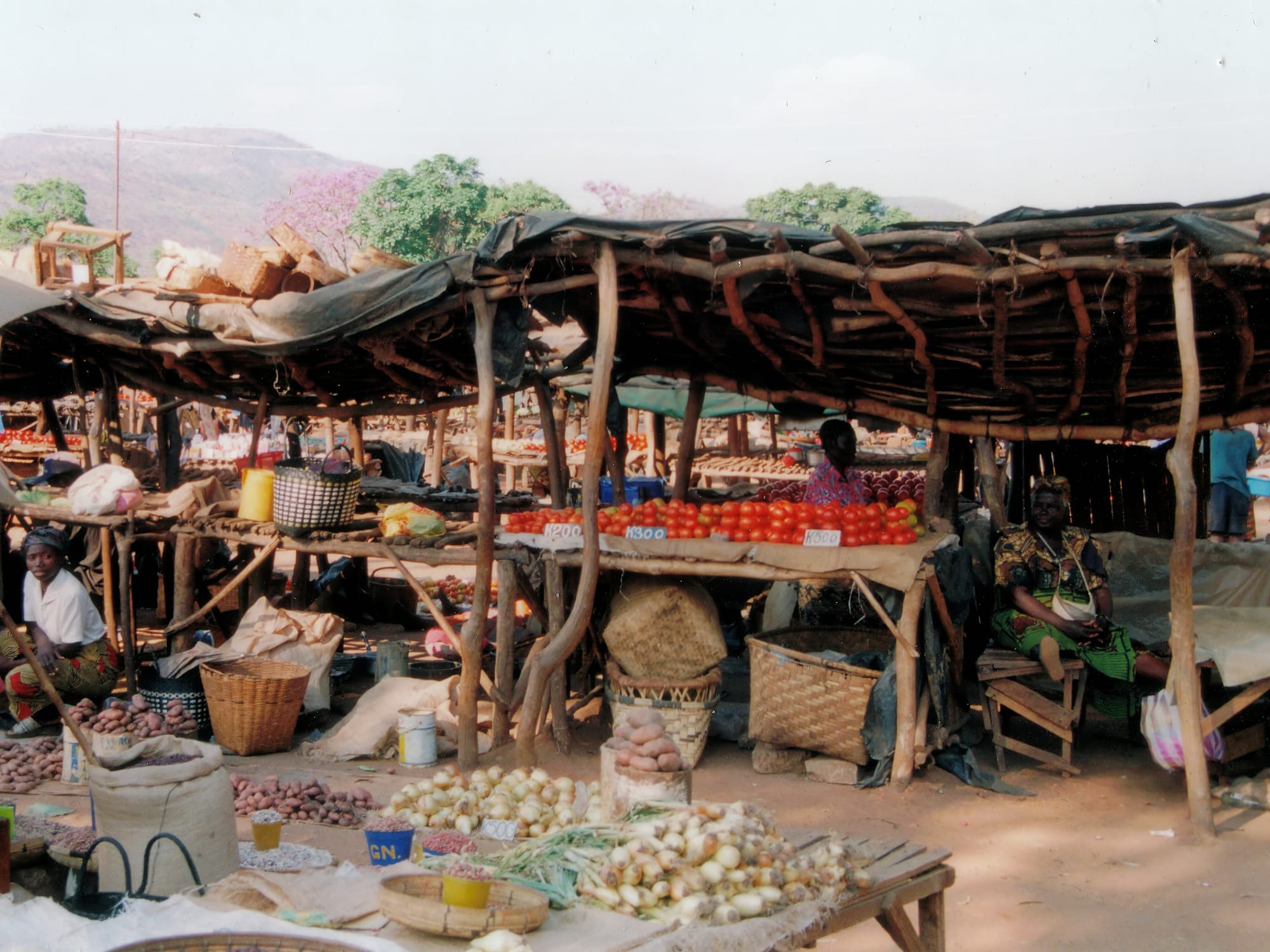
Open-air market stalls under rough timber and tarpaulin roofs, with tomatoes, onions and potatoes laid out and hills behind

Lusaka, the Copperbelt & the Luangwa Valley, Zambia

Chipata

Market stalls in Chipata, the main town of Zambia's Eastern Province. (Hans Hillewaert / Wikimedia Commons · CC BY-SA 3.0)

The capital of Zambia's Eastern Province, set in hills near the Malawian border at the end of the Great East Road from Lusaka. Founded as the colonial boma of Fort Jameson at the end of the nineteenth century and later renamed, it is a trading and farming city, the regional seat of the Ngoni of Zambia, and the road junction for travellers heading into the Luangwa Valley.

Neighbourhoods

  • The town centre
    • First-time visitors
    • Shopping
    • Close to public transport

    A compact grid of shops, banks, guesthouses and government offices around the main road, with the bus station and minibus ranks nearby. Trade, not sightseeing, is what fills it, and it is busiest in the morning when buses arrive from Lusaka and the border.

    Open in Maps
  • The market quarter
    • Markets
    • Local life
    • Street food

    The dense blocks of stalls, wholesalers and cheap eating houses that supply the town and the surrounding farming districts. Produce from the Eastern Province, dried fish, secondhand clothing and hardware are traded here, and the streets around fill with handcarts.

    Open in Maps
  • The old boma and the hills
    • History
    • Quiet and residential
    • Views

    The higher ground on the edge of town where the colonial administration built its offices and houses as Fort Jameson. Older brick buildings, churches, schools and shaded residential streets stand below wooded hills that give long views over the valley.

    Open in Maps
  • The border road
    • Transport
    • Local life

    The eastern edge of town along the road to Mchinji and Malawi, lined with fuel stations, truck stops, freight yards and lodges. Cross-border traffic between Lusaka and Lilongwe keeps it busy day and night.

    Open in Maps

Things to do

Markets and town life

  • Chipata marketmarket

    The town's main market, trading produce, groundnuts, dried kapenta, cloth and household goods from across the Eastern Province.

    Open in Maps
  • Kapataneighborhood

    The original centre of the town, whose name comes from the Chewa word for a small space, now a dense quarter of shops and stalls.

    Open in Maps
  • Down Shopsneighborhood

    Chipata's busy down-town area, where most of the shops and businesses have proprietors of Indian origin.

    Open in Maps

History and transport

  • The old Fort Jameson buildingslandmark

    Brick offices, churches and houses on the higher ground, survivors of the fortified colonial boma that gave Fort Jameson its name.

    Open in Maps
  • Chipata Airporttransit hub

    The city's airport, about 15 km north-west of the centre by road.

    Open in Maps

Short trips from the town

  • Mchinji and the Malawi borderneighborhood

    The Malawian border town on the road to Lilongwe, reached through the Mwami–Mchinji crossing east of Chipata.

    Open in Maps
  • South Luangwa National Parkpark

    Zambia's best-known wildlife park, about 100 km north-west on the road through Mfuwe, which makes Chipata the usual overland staging post.

    Open in Maps

Seasonal events

  • Nc'walalate February

    The Ngoni first-fruits ceremony, usually held at the end of February at Mutenguleni on the outskirts of Chipata, where the paramount chief tastes the new harvest and regiments perform warrior dances.

  • Kulambalate August

    The Chewa ceremony, Zambia's largest, held at the paramount chief's palace near Katete, about 75 km away, where chiefs from Zambia, Malawi and Mozambique gather to report to the Kalonga.

  • Independence Day24 October

    National celebrations marked in the provincial capital with parades, church services and sport.

Eat and drink

Long-standing places and food districts in Chipata. Hours, ratings and directions come from your maps app, always current.

Where people eat in Chipata

  • Town-centre eating housesrestaurant

    Plain restaurants around the main road serve nshima with beans, greens in groundnut sauce, kapenta or chicken, with chips and grilled meat in the evening.

    Open in Maps
  • Chipata marketmarket

    Maize meal, groundnuts, tomatoes, dried fish and seasonal mushrooms and caterpillars from the surrounding farming districts, with fritters and roasted maize sold at the edges.

    Open in Maps
  • The border road truck stopsneighborhood

    Grills, takeaways and bars along the road to Malawi, feeding long-distance drivers at all hours.

    Open in Maps

Experience Chipata

History

The hills around Chipata were Chewa country, linked to the old Maravi states, when the Ngoni arrived in the 1830s after their long migration north from what is now South Africa. The branch led by Mpezeni settled in these highlands, and his chiefdom dominated the district.

In 1897 Mpezeni rose against the British South Africa Company with a force of over 4,000 warriors and was defeated; the company then established a fortified boma, or government station, on the ridge above the plain, naming it Fort Jameson after Leander Starr Jameson. The town was the capital of North-Eastern Rhodesia from 1900 until 1911, when the administration was consolidated at Livingstone, after which it settled into the quieter role of a district and later provincial centre in farming country worked by European settlers and African farmers.

After independence Fort Jameson was renamed Chipata, and it became the capital of Eastern Province. Its position has shaped everything since: it stands at the end of the Great East Road from Lusaka, close to the Malawian border at Mwami, and at the turning for the Luangwa Valley, so goods, buses and traders move through constantly. A railway link to the Malawian network at Mchinji, about 35 km long, opened in August 2011 and made the town Zambia's eastern railhead. Growth in recent decades has come from trade, farming, government offices and the tourism traffic heading north to South Luangwa.

Culture & Customs

Chipata is the centre of Ngoni life in Zambia, and the descendants of Mpezeni's kingdom keep an unusually visible ceremonial tradition. Nc'wala, usually held at the end of February at Mutenguleni on the outskirts of the town, is the first-fruits ceremony: the paramount chief tastes the new harvest, and regiments in animal skins perform the stamping, shield-beating dances that recall the Ngoni's southern African origins. It draws crowds from across the province and beyond.

The province is mixed, however, and Chewa, Nsenga, Tumbuka and Kunda communities all trade in the town. The Chewa keep the masked Gule Wamkulu dances of the Nyau societies, a ritual tradition shared with Malawi and Mozambique. Nyanja, the language of the east, is the common speech, and it is Nyanja from this province that became the street language of Lusaka.

Chipata also has a long-settled Indian trading community, whose shops fill the down-town streets, alongside Catholic, Anglican and Pentecostal churches. Proximity to Malawi shows in everyday life: families, languages and trade cross the border constantly, and Malawian music and football are followed as closely as Zambian.

Daily Life

Chipata was declared Zambia's fifth city in 2017. About 193,000 people lived in the city at the 2022 census and some 327,000 in the district as a whole, and the numbers grow steadily as people move in from the surrounding districts. Most residents live in low-rise neighbourhoods of brick and block houses spreading outwards from the centre, with the wealthier and older housing on the higher ground near the old boma.

The economy is farming, trade and administration. The Eastern Province accounts for about a fifth of Zambia's agricultural production, with sunflower the largest crop, and Chipata is where crops are bought, stored and processed, and where farmers buy seed, fertiliser and tools. Cross-border trade with Malawi is the second pillar: trucks, informal traders and money changers work the Mwami road daily. Provincial government offices, a teaching hospital, colleges and schools employ many, and lodges and transport firms serve the steady flow of visitors bound for the Luangwa Valley.

Days begin early, with the market trading soon after dawn and minibuses filling for the villages. The concerns of the town are those of rural Zambia: the price of fertiliser and maize meal, the rains arriving on time, fuel costs, and the power cuts that follow drought. Malaria, water supply and the pressure on schools and clinics from a fast-growing population are the recurring issues in local debate.

Food

Eastern Zambia eats nshima — stiff white maize porridge — at the middle of almost every meal, taken by hand and dipped into a relish. The relishes here are the ones the province grows: beans, chibwabwa (pumpkin leaves), kalembula (sweet potato leaves) and delele (okra), very often cooked with pounded groundnuts, since this is groundnut country. Dried kapenta, small lake fish, and fish from the Luangwa add protein, and village chicken is the dish of honour.

Seasonal foods matter. The rains bring wild mushrooms, sold in heaps at the roadside, and ifinkubala or edible caterpillars, dried and fried; the first storms bring inswa, flying termites eaten fried and salted. Chikanda, the savoury loaf of wild orchid tubers and ground peanuts known as African polony, is eaten across the province. Fresh and boiled groundnuts are sold everywhere, and roasted maize cobs are the standard snack.

The town's Indian trading families have made samosas and curries part of local eating, and Malawian influence shows in the fish and the sweet fried snacks sold near the border road. Bars serve bottled Mosi lager and cartons of thick Chibuku sorghum beer, while munkoyo, the lightly fermented maize-and-root drink, is sold in the markets and villages.

Planning tools

Budget

Chipata is inexpensive. Guesthouses aimed at traders and government travellers are cheap, market meals cost very little, and buses are the normal way to arrive. Costs rise only for those hiring a vehicle for the Luangwa Valley, which is the main reason most visitors stop here.

Daily Budget Midrange
USD 130–300 (lodge room, restaurant meals, a hired vehicle with driver for the valley or the border)
Daily Budget Shoestring
USD 30–60 (guesthouse, market and canteen meals, buses and shared taxis)

Carry kwacha cash: card acceptance is limited outside the banks and larger lodges, and traders at the border prefer cash.

Best Time to Visit

May to August is dry, sunny and comfortable, and the roads into the Luangwa Valley are at their best. September and October are hot before the rains. Nc'wala falls at the end of February, in the middle of the wet season, when the surrounding hills are green and unsurfaced roads are difficult.

Suggested Number of Days

Most people pass through in a day, breaking the journey between Lusaka, the Luangwa Valley and Malawi. Two or three days suit anyone visiting the Ngoni and Chewa ceremonies, the border districts or the farming country around the town.

First Visit
1 day
With Surroundings
2–3 days

Transportation

Minibuses and shared taxis work the town and the nearby villages from ranks near the market, and long-distance coaches use the bus station. Taxis are easy to find in the centre. Beyond the tarred roads a 4x4 is needed, particularly in the rains, and the run north into the valley is partly unsurfaced.

Agree a taxi fare in advance, and book valley or border transport the day before rather than on the morning of travel.

Airport & Station Connections

The Great East Road from Lusaka ends here after about 570 km, a long day by coach or car, with buses running daily. The Mwami border with Malawi is about 30 km east, and Lilongwe about 150 km from the town. Chipata Airport lies about 15 km north-west of the centre, and Mfuwe, for South Luangwa, is about 100 km north-west by road.

Walkability

The centre is small and easily walked: the market, the bus station, the banks and most guesthouses are within a few blocks of each other. Pavements fade quickly on the outskirts, the hills make for steep going, and the border road carries heavy truck traffic, so walking further out is less pleasant. Streets are poorly lit after dark.

Safety

Chipata is calm, and crime against visitors is uncommon. The usual precautions apply around the market and bus station, where pickpocketing occurs, and the border road is busy with trucks. Malaria is a year-round risk in the province, and power cuts during droughts affect the town.

Use registered taxis at night in Lusaka and the Copperbelt, take malaria precautions, and follow camp rules about walking after dark. Keep valuables out of sight around the market and the bus station. Check current official travel advice before travelling.

Climate

Chipata sits on high ground at about 1,180 metres, so it is cooler than the Luangwa Valley below it. The year runs dry and mild from May to August, hot in September and October, and warm and wet from November to April, when storms fall in the afternoon.

Summer
December to February is warm and wet, with days around 27–30°C and heavy rain
Winter
June and July are dry, with days around 24–26°C and cool nights

Local Customs

This is Ngoni and Chewa country, with Nsenga, Tumbuka and Chewa-speaking communities across the province and Nyanja as the common language. Chiefs hold real authority over customary land, ceremonies are taken seriously, and churches are central to town life. Greetings come before business, and elders are addressed first.

Dress modestly in town and at ceremonies, ask before photographing people, dancers or places of worship, and expect border and police posts to object to cameras.

Common Payment Methods

The currency is the Zambian kwacha. Banks and ATMs are in the centre, and larger lodges take cards, but markets, minibuses and small shops are cash only. Malawian kwacha circulates informally near the border, and mobile money is widely used by residents.