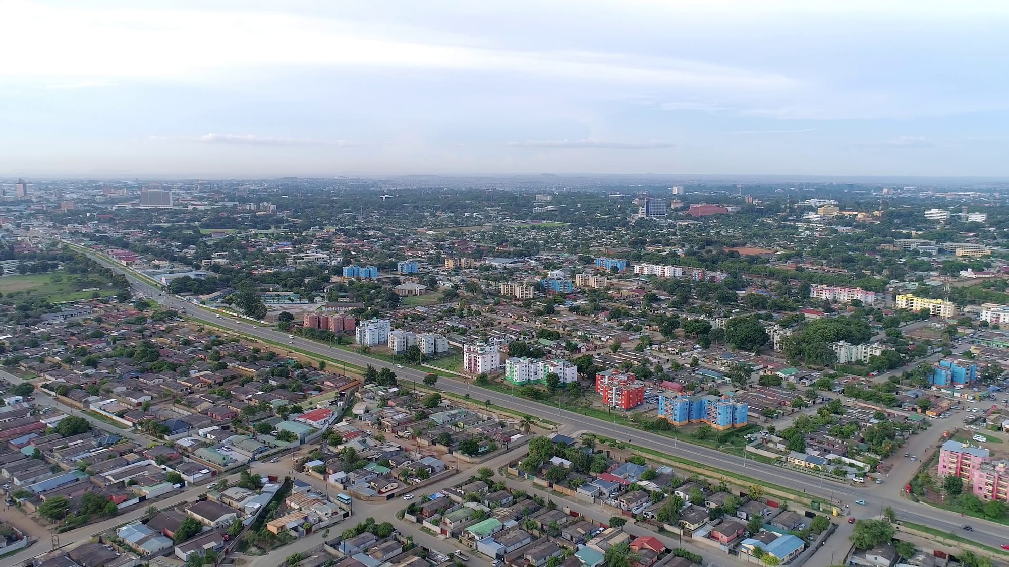
Aerial view over Lusaka, with a wide dual carriageway cutting between low houses, blocks of flats and trees towards distant towers

Lusaka, the Copperbelt & the Luangwa Valley, Zambia

Lusaka

Lusaka from the air, looking across low-rise suburbs and flats towards the city centre. (Icem4k / Wikimedia Commons · CC BY-SA 4.0)

Zambia's capital and largest city, on the central plateau at about 1,280 metres. A railway siding named after a local headman, it replaced Livingstone as the capital in 1935 and has grown into the country's centre of government, trade and air travel — a working city of markets, wide avenues, craft centres and spreading suburbs rather than a sightseeing one.

Neighbourhoods

  • The city centre and Cairo Road
    • First-time visitors
    • Shopping
    • Close to public transport

    The commercial core, built along the broad dual carriageway of Cairo Road, named for its place on the old Cape-to-Cairo route. Banks, chain shops, bureaux de change, street traders and the main minibus stations are concentrated here, and the city's oldest business blocks stand behind the pavement arcades. It empties in the evening.

    Open in Maps
  • Ridgeway and Longacres
    • Museums
    • Government quarter
    • Quiet and residential

    The planned government and diplomatic district south-east of the centre, laid out with wide, tree-lined roads. Ministries, embassies, the main hospital and several of the city's larger hotels stand among gardens, with the National Assembly grounds and Independence Avenue nearby.

    Open in Maps
  • Rhodes Park and Northmead
    • Best for food
    • Nightlife
    • Central

    Older inner suburbs just north and east of the centre, with 1950s houses converted into offices, restaurants and guesthouses. Northmead's shopping parade is a long-standing cluster of bars, takeaways and small shops, busy into the evening.

    Open in Maps
  • Kabwata
    • Crafts
    • Local life

    A densely built residential area south-east of the centre, one of the city's long-established townships. The Kabwata Cultural Village, a compound of rondavel workshops, sells carvings, baskets, textiles and drums made on site.

    Open in Maps
  • Kabulonga and Woodlands
    • Quiet and residential
    • Best for food

    Green, low-density suburbs south-east of the centre, with large plots behind walls, embassies, international schools and most of the city's shopping malls and sit-down restaurants. Little happens on foot, but this is where much of Lusaka's expatriate and professional population lives.

    Open in Maps
  • Chilenje
    • History
    • Local life

    A township laid out in the 1950s, where Kenneth Kaunda lived before independence; his house is preserved as a national monument. Streets of small municipal houses, bars and markets give a sense of everyday Lusaka away from the malls.

    Open in Maps

Things to do

Museums and memorials

  • Lusaka National Museummuseum

    The national museum, opened to the public in 1996, with archaeology and history on the ground floor and a contemporary Zambian art gallery above.

    Open in Maps
  • Freedom Statuelandmark

    A figure breaking chains, erected in 1974 for the tenth anniversary of independence, shown on the kwacha and the focus of Africa Day ceremonies.

    Open in Maps
  • Chilenje House 394museum

    The small township house where Kenneth Kaunda lived from 1960 to 1962 and directed the independence campaign, restored as a national monument and museum.

    Open in Maps

Landmarks and buildings

  • Cathedral of the Holy Crosslandmark

    The Anglican cathedral on Cathedral Hill, built in 1962, and the seat and mother church of the Diocese of Lusaka.

    Open in Maps
  • National Assembly of Zambialandmark

    The seat of Zambia's parliament, in its own grounds on the edge of the government district.

    Open in Maps
  • Cairo Roadlandmark

    The four-kilometre multi-lane road that is the central business district's main artery, lined with shops and offices and holding four of Zambia's five tallest buildings.

    Open in Maps

Markets and crafts

  • Kabwata Cultural Villagemarket

    An area of preserved older housing in Kabwata township, given over to craft workshops where carvers, weavers and drum makers work and sell.

    Open in Maps
  • Central Market and New City Marketmarket

    The two big markets immediately west of Cairo Road, dense blocks of stalls selling produce, fish, hardware and second-hand clothes.

    Open in Maps
  • Soweto Marketmarket

    A huge market on Lumumba Road, a modern covered hall at the front and a sprawl of stalls behind selling beans, used clothes, traditional medicines and engine parts.

    Open in Maps

Parks and wildlife

  • Lusaka National Parkpark

    Zambia's smallest and newest national park, entirely fenced, established in 2011 and opened in 2015 on the south-eastern edge of the city.

    Open in Maps
  • Munda Wanga Environmental Parkpark

    Botanical gardens, a zoo and a wildlife sanctuary at Chilanga, south of the city, long a weekend outing for Lusaka families.

    Open in Maps

Short trips from the city

  • Kenneth Kaunda International Airporttransit hub

    The national gateway about 27 km north-east of the centre, off the Great East Road, where a second terminal for international flights opened in August 2021.

    Open in Maps

Seasonal events

  • The annual agricultural showAugust

    The yearly agricultural and commercial show at the Agricultural Society showgrounds in Lusaka, with livestock, machinery and trade stands; the national Farmers' Day holiday falls on the first Monday in August.

  • Independence Day24 October

    National celebrations across the capital on the anniversary of independence in 1964, with parades, church services and street parties.

  • African Freedom Day25 May

    A public holiday marked in the capital, with the Freedom Statue as the focus of official ceremonies.

Eat and drink

Long-standing places and food districts in Lusaka. Hours, ratings and directions come from your maps app, always current.

Lusaka classics

  • Nshima and relish at a local restaurantrestaurant

    Plain canteens across the city serve the national meal — stiff maize porridge eaten by hand with beans, greens in groundnut sauce, kapenta or village chicken.

    Open in Maps
  • Braai and grilled meat barsrestaurant

    Open-air grills across the suburbs cook beef, goat and chicken over charcoal, usually with nshima, chips or roasted maize alongside.

    Open in Maps

Markets and food districts

  • Central Market and New City Marketmarket

    The produce markets west of Cairo Road, where vegetables, dried kapenta, groundnuts and wild mushrooms in season arrive from across the country.

    Open in Maps
  • Soweto Marketmarket

    The city's great everything-market on Lumumba Road, where sacks of beans and other staples are sold in the yards behind a modern covered front hall.

    Open in Maps
  • Kamwalaneighborhood

    A busy trading district south of the centre, where cheap eating houses, curry houses and samosa stalls sit among the shops.

    Open in Maps
  • Northmeadneighborhood

    An inner suburb whose shopping parade holds bars, bakeries, takeaways and small restaurants, one of the more walkable eating strips in the city.

    Open in Maps
  • Arcades and Manda Hill restaurantsneighborhood

    The Great East Road malls are where much of middle-class Lusaka eats out, with grills, cafés and international chains grouped together.

    Open in Maps

Experience Lusaka

History

Lusaka takes its name from Lusaaka, a Lenje headman whose village stood near the site when the railway from the south was pushed north through the plateau in the first years of the twentieth century. A siding opened in 1905, and a small settlement of European farmers and traders grew around it, serving the maize farms of the surrounding district.

Its promotion was an act of planning rather than growth. Northern Rhodesia's capital had been Livingstone, on the Zambezi in the far south, and in 1929 the administration decided to move it to a more central point on the line of rail. The new capital was laid out with a garden-city plan drawn up under Professor Stanley Adshead, and the transfer took effect in 1935. Cairo Road, the wide central avenue, took its name from the Cape-to-Cairo route, and separate townships were built for African workers away from the European suburbs.

Lusaka became the centre of nationalist politics in the 1950s and 1960s, and the seat of independent Zambia from October 1964. Under Kenneth Kaunda it also sheltered exiled activists from the liberation movements of southern Africa, and has been described as the centre of anti-colonial resistance for the region. The city has grown far faster than its services: the planned suburbs are now ringed by large unplanned compounds, and the population has multiplied many times over since independence, making Lusaka one of the fastest-developing cities in southern Africa.

Culture & Customs

Lusaka is the one place in Zambia where all the country's peoples mix. Nyanja, the language of the east, has become the common street speech, and English the language of work, school and signage, with Bemba, Tonga and Lozi all heard in the markets. That mixture has made the capital the centre of a national popular culture rather than a regional one.

Music runs through the city. The Zamrock bands of the 1970s played the township halls; today Zambian hip-hop, kalindula and gospel come out of studios in the inner suburbs and fill minibus radios and bars. Churches are a central institution, from cathedrals in the government quarter to enormous Pentecostal halls in the compounds, and Sunday is quiet until services end. Football is followed closely, and international matches at the National Heroes Stadium empty the streets.

Craft and visual art have an established base here: the Kabwata Cultural Village brings carvers and weavers from several provinces into one compound, and a small gallery scene shows contemporary Zambian painting and sculpture. Manners are formal by regional standards — elders are greeted first, titles are used, and patience and courtesy carry more weight in a transaction than directness.

Daily Life

More than two million people live in the city and its surrounding district, drawn from every province, and the population is young: a large share is under twenty-five. About 70 per cent of residents lived in unplanned settlements in 2015, on the western, southern and northern fringes, where water, drainage and electricity connections lag well behind the building.

The economy is government, trade and services rather than industry: ministries and parastatals, banks and mobile-money agents, wholesalers, transport firms and a growing retail sector built around the malls on Great East Road. Small-scale trading employs an enormous number of people, from market stalls to vendors working the traffic queues. Farms on the outskirts supply maize, vegetables and flowers, some of the last flown to Europe.

The day starts early. Minibuses fill before dawn, markets are trading by seven, and offices work through to late afternoon. Conversation turns on the price of mealie meal and fuel, on the kwacha, and on load-shedding: when drought lowers the levels at the hydroelectric dams, power cuts run for long stretches of the day and businesses fall back on generators. Water supply and sanitation in the crowded settlements remain serious public health concerns.

Food

Nshima is the fixed point of the Lusaka table, as it is everywhere in Zambia — a stiff white maize porridge rolled into a ball by hand and dipped in relish. The relishes reflect the eastern and central provinces that feed the capital: chibwabwa (pumpkin leaves), kalembula (sweet potato leaves) and delele (okra), often cooked with pounded groundnuts, alongside beans, dried kapenta from the lakes, and village chicken, which is prized over broiler birds.

Street and market food is substantial. Vitumbuwa, small fried dough balls, are sold from basins in the morning; roasted maize cobs, boiled groundnuts and sugarcane are hawked at junctions; and grilled beef or goat from a charcoal braai, cut up and shared from a common plate, is the standard evening meal out. Chikanda, the savoury loaf of wild orchid tubers and peanuts sometimes called African polony, has moved from the countryside onto restaurant menus in town. Seasonal foods punctuate the year: wild mushrooms and caterpillars in the rains, inswa — fried flying termites — after the first heavy storms.

Lusaka's long-settled Gujarati-speaking Indian community has given the city curry houses and samosa stalls, and the malls add pizza, burgers and South African chains. The drinks are Mosi lager, brewed in the country, thick Chibuku sorghum beer sold by the carton, munkoyo, a lightly fermented root and maize drink, and very sweet tea.

Planning tools

Budget

Lusaka is inexpensive for food, markets and minibuses, but hotel rooms and taxis are priced for business travellers and aid workers, and there is little public transport a visitor can use easily. Most budgets are decided by accommodation and by how much private transport is needed to cross a spread-out city.

Daily Budget Midrange
USD 130–300 (city hotel, restaurant meals, taxis or a hired car with driver, museum and park entry)
Daily Budget Shoestring
USD 45–80 (guesthouse or backpackers, market and canteen meals, minibuses and shared taxis)

Agree a taxi fare before setting off, since fares are not metered, and expect to pay park and museum entry in kwacha cash.

Best Time to Visit

May to August is the most comfortable stretch, dry and sunny with cool nights. September and October are hot and dusty before the rains, and from November to March heavy afternoon storms green the city and can flood unsurfaced roads. The agricultural show falls in the dry season.

Suggested Number of Days

A day or two covers the capital itself, which is more a place to arrange things than to sightsee. Three or four days allow for the parks and gardens on the city's edge, or for waiting out flight connections to the safari areas. Traffic and distances stretch every plan.

First Visit
1–2 days
With Surroundings
3–4 days

Transportation

Blue minibuses run fixed routes from the city-centre stations to the townships and suburbs, cheaply but slowly and without route maps in English. Visitors mostly use taxis, hired cars with drivers or ride-hailing apps. Traffic on Great East Road and Cairo Road is heavy at the start and end of the working day.

Use a registered taxi or an app rather than flagging a car down, and allow extra time for the morning and evening rush.

Airport & Station Connections

Kenneth Kaunda International Airport lies about 27 km north-east of the centre, half an hour or so by road outside peak hours, and is Zambia's main international gateway as well as the hub for light aircraft to the safari areas. Long-distance coaches from the Copperbelt, Livingstone, Chipata and neighbouring countries use the intercity bus terminus near the centre.

Walkability

Cairo Road and the surrounding blocks can be walked, and the government quarter is pleasant on foot by day, but Lusaka was built around the car. Suburbs are spread out behind walls, pavements are intermittent and unlit, and distances between districts are long, so most people drive or take a taxi even for short journeys. Walking after dark is not usual.

Safety

Lusaka is calm by regional standards and serious crime rarely touches visitors, but pickpocketing and bag-snatching are common in the markets, around the bus stations and on Cairo Road, and theft from vehicles happens in traffic. Road conditions and drought-driven power cuts are the other practical problems.

Use registered taxis at night in Lusaka and the Copperbelt, take malaria precautions, and follow camp rules about walking after dark. Carry a torch and a power bank for load-shedding. Check current official travel advice before travelling.

Climate

The altitude of about 1,280 metres keeps Lusaka milder than its latitude suggests. The year divides into a cool dry season from May to August, a hot dry spell in September and October, and a warm wet season from November to April with heavy afternoon storms.

Summer
December to February is warm and wet, with days around 26–30°C and frequent downpours
Winter
June and July are dry and sunny, with days around 23–25°C and nights that can fall to 5–10°C

Local Customs

Greetings matter: a handshake, often with the left hand supporting the right forearm, and a few words of enquiry before business. Nyanja is the street language, though English is official and widely spoken. Churches are full on Sundays and dress in town is conservative — long trousers or skirts are usual, and smart clothing is respected in offices.

Ask before photographing people, and avoid photographing government buildings, the airport, bridges and police or military posts. Tipping is modest — rounding up a taxi fare, or about 10 per cent in a restaurant where service is not included.

Common Payment Methods

The currency is the Zambian kwacha. Cards work in malls, hotels and larger restaurants, and ATMs are plentiful in the centre and the suburbs, but markets, minibuses and small shops are cash only. Mobile money is widely used by residents. US dollars are accepted for some tour and lodge payments but not for everyday purchases.