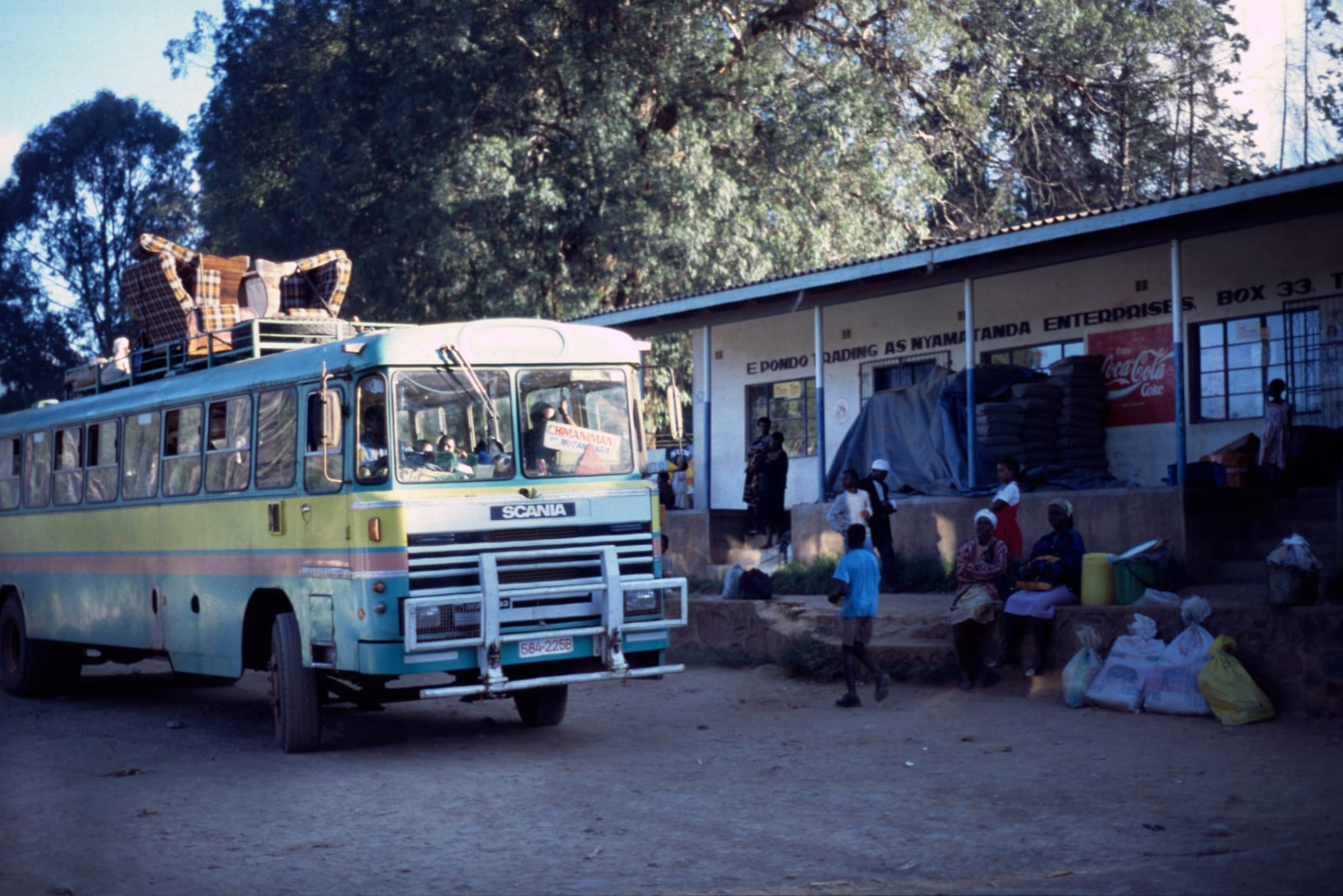
A pale green and yellow country bus with luggage roped to its roof, parked on bare ground beside a long veranda of village shops

The Eastern Highlands, Zimbabwe

Chimanimani

The bus station in Chimanimani village, the terminus for services from Mutare. (Ralf Ellerich / Wikimedia Commons · CC BY-SA 3.0)

A small village in the southern Eastern Highlands of Zimbabwe, laid out below the quartzite wall of the Chimanimani mountains on the Mozambican border. Founded by settlers as Melsetter and renamed in 1982, it lives by farming, timber and hikers, and it was among the places worst hit when Cyclone Idai struck in March 2019.

Neighbourhoods

  • Village centre
    • First-time visitors
    • Shops and transport

    A single green square with a handful of shops, a bank, a hotel, the bus stop and district offices, ringed by pines and jacarandas with the mountains standing behind. Everything in the village is a few minutes' walk from it.

    Open in Maps
  • Ngangu
    • Local life
    • Markets

    The high-density township on the slope above the village, where most of the population lives, with vendors, tuckshops, churches and schools. It was among the areas hit by the flooding and landslides of March 2019, and much of it has been rebuilt since.

    Open in Maps
  • The park road and the outlying farms
    • Walks
    • Quiet and residential

    The rough road running south-west towards the national park gate, past smallholdings, plantations and a scattering of lodges, cottages and campsites. This is where most walkers stay and where the mountain paths begin.

    Open in Maps

Things to do

The mountains

  • Chimanimani National Parkpark

    Established in 1949 and now covering about 155 square kilometres of the Zimbabwean side of the range, with quartzite ridges and montane grassland reached only on foot.

    Open in Maps
  • Monte Bingatrail

    The highest point of the range at about 2,440 metres, the highest mountain in Mozambique and the second-highest in Zimbabwe, standing on the border ridge and climbed from the Zimbabwean valley below.

    Open in Maps

Around the village

  • Bridal Veil Fallsattraction

    A waterfall dropping into a pool in forest about 5 kilometres from the village, in a small national park reached by a short drive or on foot, with a picnic and camping site beside it.

    Open in Maps
  • The Arboretum and Pork Piepark

    The arboretum, Green Mount and the Pork Pie sanctuary, small protected patches of hill and woodland close to the village.

    Open in Maps

Short trips from the village

  • Chirinda Forestpark

    A patch of tall evergreen forest on the slopes of Mount Selinda south of Chipinge, the southernmost subtropical rainforest in Africa, known for its huge mahogany trees.

    Open in Maps
  • Chipingeattraction

    The market town at the centre of Zimbabwe's tea and coffee country, where the first tea in the country was grown from seed brought from Assam in 1924.

    Open in Maps

Eat and drink

Long-standing places and food districts in Chimanimani. Hours, ratings and directions come from your maps app, always current.

Everyday eating

  • Village centre eating placesneighborhood

    A few small kitchens and takeaways around the square serving sadza with stew and greens, rice and chips, and tea with buns in the morning.

    Open in Maps
  • Ngangu market stallsmarket

    Vegetables, bananas, avocados and maize from the surrounding smallholdings, sold from stalls and roadside tables, with vendors roasting maize alongside.

    Open in Maps
  • Lodge and campsite kitchensneighborhood

    The places on the park road cook simple set meals for walkers, and most visitors staying longer buy supplies in the village or in Mutare and cook for themselves.

    Open in Maps

Experience Chimanimani

History

The Ndau, whose language and families extend across the mountains into central Mozambique, have farmed these valleys for centuries, and the range was a corridor for trade between the plateau and the Indian Ocean coast long before any European arrived. The border drawn between British and Portuguese territory in the 1890s cut straight through that world and left relatives on either side of a ridge.

A party of settlers who trekked north under Thomas and Dunbar Moodie founded a settlement in these hills in 1892, moved it to the present site in 1895 and called it Melsetter after the Moodie family home in Orkney. It became a small farming and forestry centre, its altitude and rainfall suiting timber, coffee, fruit and cattle, and it kept the name until 1982, when it was renamed Mandidzudzure and then, after consultation with residents, Chimanimani. The national park on the Zimbabwean side of the range was established in 1949, covering 82 square kilometres at first and about 155 today.

The border made the district a front line during the liberation war of the 1970s, with guerrillas crossing from Mozambique and heavy fighting in the surrounding country, and afterwards it saw the spillover of Mozambique's own long conflict. Its hardest modern blow came in March 2019, when Cyclone Idai crossed from Mozambique and the resulting floods and landslides killed at least 634 people in Zimbabwe, at least 169 of them in Chimanimani, with the Chimanimani and Chipinge districts hit hardest. The village was cut off, roads and bridges were destroyed, and the district still bears the marks of that week.

Culture & Customs

Chimanimani is Ndau country, and its culture looks east as much as west. Ndau is distinct enough from the Shona dialects of the plateau to be considered a separate language by many of its speakers, and the music, dance and spirit traditions of the district are shared with Mozambican communities over the ridge. Cross-border family ties, trade and church networks are ordinary facts of life here.

Spiritual practice is layered. Mission churches founded in the colonial period sit alongside independent and apostolic congregations, and traditional healers and spirit mediums are consulted widely; certain hills, pools and groves are treated as sacred and are not entered casually, something visitors are expected to respect when walking. Ceremonies to ask for rain, and gatherings after a death, draw people back from the cities.

The village also has a long-standing second identity as a walkers' and artists' retreat — a place Zimbabweans go for quiet, cold air and mountains, with a small resident community of craftspeople, growers and lodge keepers, and a tradition of music and arts gatherings in the village. Since 2019 the memory of the cyclone has become part of local identity too: the anniversary is marked, and rebuilding and relocation are constant subjects of conversation.

Daily Life

Chimanimani is a village of a few thousand people, most of them living in Ngangu above the old square, serving a mountainous district of scattered homesteads and farms. Government offices, a hospital, schools and the police account for many of the formal jobs, along with timber, a handful of lodges and the park.

Farming carries everything else. Smallholders grow maize, beans, bananas, potatoes and vegetables on steep plots, coffee and macadamia are grown commercially in the district, and pine and eucalyptus plantations cover whole hillsides. Prices are higher than in Mutare because everything comes up the mountain road, and cash is short: many families rely on relatives working in South Africa, Mozambique or the cities.

The rhythm is early and weather-bound. Transport leaves in the morning and thins out by afternoon, mist can shut the village in for a day, and power cuts and patchy mobile signal are normal. Since the 2019 cyclone a good deal of daily life has involved rebuilding — houses, roads, bridges and schools — and some families were moved to safer ground away from the slopes where landslides ran.

Food

The everyday plate is sadza, the stiff maize-meal porridge, eaten by hand with a relish of covo or rape greens cooked with tomato and onion, beans, okra, or beef or chicken stew when the household can afford it. Peanut butter is stirred into greens and into bota, the thinner breakfast porridge, and dried kapenta and matemba fish carried up from the lowlands add protein.

The mountains give the district its own produce. Bananas, avocados, mangoes, macadamia nuts and coffee grow in the warmer valleys, potatoes, cabbages and temperate fruit on the cool uplands, and honey is collected in the forests and sold at the roadside. Wild mushrooms appear after the first rains and are a seasonal delicacy, gathered in the pine and msasa woodland and cooked simply with onion.

Tea and coffee from the Chipinge estates to the south are the district's best-known drinks, taken strong and sweet against the cold mornings. Maheu, the thick fermented maize drink, home-brewed sorghum beer for ceremonies and gatherings, Chibuku from cartons in the beer halls and the usual national lagers complete the picture, and lodges cook plainer fare for walkers coming off the hill.

Planning tools

Budget

Chimanimani is inexpensive. Camping and simple lodges, village food and the hut in the mountains cost little beyond the park fee, and the main expense is getting here and hiring a vehicle or a guide. Supplies are cheaper and more varied in Mutare than in the village shops.

Daily Budget Midrange
USD 90–200 (a lodge or cottage, car hire, guided hikes and park fees)
Daily Budget Shoestring
USD 30–55 (a campsite or backpackers, village food, buses and lifts)

Bring US dollar cash in small notes and buy food before arriving, as the village shops carry a limited range and card payment is rarely possible.

Best Time to Visit

April to October is the walking season, with dry paths, clearer skies and cold nights, and May to August is the crispest time on the high ground. The rains from November to March bring heavy storms, mist, leeches on the paths and swollen rivers, and the mountains are often invisible for days at a time.

Suggested Number of Days

Two or three days suit the village and a first walk in the range. Four to six allow for longer routes with a night in the mountains and time in the wider district. The number depends mostly on the weather and on how much walking is planned.

First Visit
2–3 days
With Surroundings
4–6 days

Transportation

The village is small enough to walk from end to end. Buses and kombis run to Mutare and to the district's villages, but they are infrequent and stop early in the day. There is no transport into the national park: the last stretch to the gate is a rough road, and everything beyond it is on foot. Lifts and hired pick-ups fill the gaps.

Use a high-clearance vehicle on the park road and the back roads, start journeys early because transport dries up by mid-afternoon, and keep documents and small change ready for police roadblocks.

Airport & Station Connections

The village lies about 120 kilometres south of Mutare by a paved road that turns to a winding mountain climb for the last stretch, a drive of about three hours; buses take considerably longer. Harare is a full day away by road. The nearest airports are at Mutare and Harare, so almost everyone arrives by road.

Walkability

The village itself is tiny and walked in minutes, though Ngangu sits up a steep slope from the square. Beyond that, walking means hill walking: the park gate is some distance out on a rough road, and the routes inside the range are unmarked in places, steep and river-crossed.

Safety

The district is peaceful and welcoming, and crime against visitors is rare. The risks are the mountains and the weather — steep and slippery paths, rivers that rise fast in rain, thick mist, cold nights at altitude and no mobile signal in the valley beyond the ridge. Landslide scars and damaged roads from the 2019 cyclone remain in places.

Take malaria precautions in the low-lying areas, avoid political gatherings, don't drive at night, keep documents and small change ready for roadblocks, and don't swim in still fresh water outside managed sites. Register with park staff or walk with a guide, carry warm and waterproof clothing, and do not cross rivers in flood. Check current official travel advice before travelling.

Climate

Cool, green and among the wettest parts of Zimbabwe, as the range catches moisture carried in from the Indian Ocean. Summer falls in December to February and winter in June to August, as elsewhere in the southern hemisphere.

Summer
warm and very wet, generally 20–26°C with mist, heavy storms and occasional cyclone rain
Winter
dry and sunny days of 15–22°C with cold nights and frost on the high ground

Local Customs

Ndau, a language shared with central Mozambique, is widely spoken here alongside Shona and English, and families often have relatives across the border. Greetings come first in any exchange, elders are greeted before anyone else, and chiefs and headmen carry authority in the rural areas. Churches, including the apostolic groups that meet outdoors, are central to community life.

Ask before photographing people, homesteads or damaged buildings, raise the 2019 cyclone gently since many families lost relatives, and tip guides and porters a small amount.

Common Payment Methods

The US dollar handles most payments, alongside the ZiG, and Mozambican metical circulates informally near the border. There is little or no reliable card payment and cash machines cannot be counted on, so enough small dollar notes for the whole stay should be brought from Mutare.