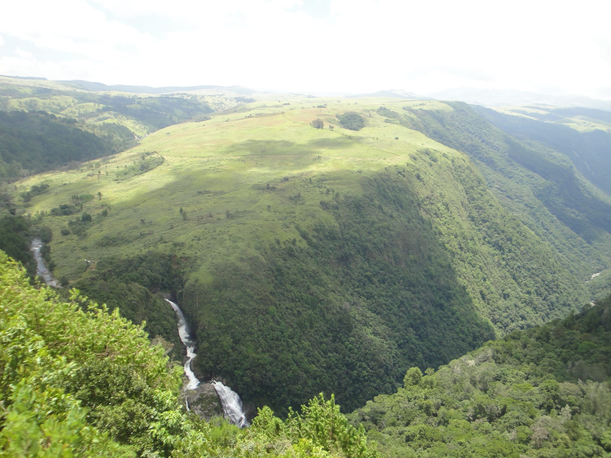
A waterfall dropping into a deep forested gorge beneath a broad grassy ridge under a hazy sky

Zimbabwe

The Eastern Highlands

The Pungwe Falls and gorge in Nyanga National Park, in the Eastern Highlands of Zimbabwe. (Babakathy / Wikimedia Commons · CC0)

Manicaland, Zimbabwe's eastern province, where the plateau rises into a chain of mountains along the Mozambican border — from Nyanga in the north through the Vumba around Mutare to Chimanimani in the south. A cool, wet, green region of forest, waterfalls, tea estates and pine plantations, it is unlike the rest of the country.

Explore The Eastern Highlands

History

The eastern mountains have been farmed for centuries. Across the Nyanga uplands lie the ruins of a large agricultural society of roughly the fifteenth to eighteenth centuries: stone-walled terraces, hill forts and sunken stone pits, best seen at Ziwa. The Manyika people, who gave Manicaland its name, formed chiefdoms here.

Britain and Portugal disputed the area in 1890–91 before the 1891 treaty passed it from Portuguese to British control. The settlement of Umtali, now Mutare, was moved in the 1890s to its present valley to meet the railway to Beira, and settlers took up land around Melsetter, now Chimanimani, and on the Nyanga plateau, where Cecil Rhodes owned an estate. Timber, tea and coffee plantations followed in the twentieth century.

After Mozambique's independence in 1975, ZANLA guerrillas crossed the eastern border from bases there, and the highlands saw heavy fighting in the final years of the war. Since independence the region has lived through land reform, which transferred many settler farms, the rush to the Marange diamond fields from 2006, where soldiers took over mining amid reports of serious abuses, and Cyclone Idai in March 2019, whose floods killed at least 634 people in Zimbabwe, with Chimanimani and Chipinge districts hit hardest.

Culture & Customs

The region's Shona speakers mostly use the Manyika dialect, while Ndau, a distinct language shared with central Mozambique, is spoken around Chipinge and Chimanimani. Families on both sides of the border are often related, and trade, marriage and migration cross it constantly.

Manicaland has a strong religious life. Mission churches and schools are prominent, and the United Methodist-related Africa University stands outside Mutare. The white-robed apostolic churches, including the Apostles of Johane Marange, founded in 1932, have their roots in the province, and their open-air gatherings are a common sight on Saturdays.

Mountains carry spiritual weight. Mount Nyangani has an air of mystery, and stories of walkers vanishing in its mists are widely told. The cool climate and the old country hotels also give the highlands a long-standing role as the country's holiday retreat.

Daily Life

Mutare, with around 200,000 people, is the region's city and Zimbabwe's gateway to the Indian Ocean: the road, railway and fuel pipeline to Beira pass through it, and cross-border trade is a major livelihood. Rusape, Chipinge, Nyanga and Chimanimani are the other towns, serving farming districts around them.

Plantation agriculture is a mainstay: tea on the estates of the Honde valley and Chipinge, coffee, macadamia nuts, fruit, and pine and eucalyptus timber on the slopes. Smallholders grow maize, potatoes and vegetables in the uplands. The Marange diamond fields and informal gold panning add mining income, often contested.

As elsewhere in Zimbabwe, households cope with erratic currencies, from the collapse of the Zimbabwe dollar to the ZiG, by using US dollars, and many families rely on relatives working in South Africa or overseas. Chimanimani, cut off by Cyclone Idai in 2019, still bears its marks.

Food

Sadza is the staple, eaten with muriwo greens, beans and stews, but the highlands add ingredients rarely grown elsewhere in the country. Mealie meal also makes bota, a thinner porridge often flavoured with peanut butter, and rice cooked with peanut butter and dried kapenta are eaten here as across Zimbabwe.

The cool uplands produce potatoes, cabbages and temperate fruit, and trout from the dams and streams of Nyanga appears on local hotel menus. The warmer valleys grow fruit, and roadside stalls sell it by the bucket.

This is also Zimbabwe's tea and coffee country: Chipinge grew Zimbabwe's first tea in 1924 and later coffee, the Honde valley is a major tea area, and hot sweet tea is the drink of the cold mornings. Maheu, the fermented maize drink, and home-brewed sorghum beer are the traditional village drinks.

Attractions & Natural Wonders

In the north, Nyanga National Park covers a high plateau of grassland, pine and streams around Mount Nyangani, at about 2,590 metres Zimbabwe's highest mountain. Its sights include the Pungwe Falls and gorge, trout dams and old stone forts and pit structures. At the edge of the escarpment, the Mtarazi Falls, often cited as the highest in Zimbabwe, pour towards the Honde valley below, where tea estates cover the slopes.

Mutare sits in a bowl of hills, with the Cecil Kop nature reserve on its edge and a museum in the town. Above it, the Vumba mountains are cloaked in mist and forest, and the Vumba Botanical Gardens have exotic trees, streams and paths through the native forest.

South of Mutare, the Chimanimani mountains form a rugged quartzite wall along the border. Chimanimani National Park, established in 1949, protects the Zimbabwean side of the range and its quartzite grasslands. Nearby, the Bridal Veil Falls are a short drive from the small town of Chimanimani.

Cities in The Eastern Highlands

Planning basics

Budget

The Eastern Highlands are one of the better-value parts of Zimbabwe. Mutare has cheap guesthouses and local transport, and the national parks lodges and campsites in Nyanga and Chimanimani are modestly priced, though some need self-catering. A few upmarket hotels and golf resorts in Nyanga and the Vumba cost far more. Walking is free apart from park fees.

Daily Budget Midrange
USD 90–200 (country hotels or lodges, car hire, guided hikes)
Daily Budget Shoestring
USD 35–60 (guesthouses or park campsites, kombis, local food)

Bring US dollar cash in small notes, as card payments and cash machines are unreliable outside Mutare.

Safety

The highlands are generally peaceful and welcoming. The main risks are natural: sudden mist on Mount Nyangani, where hikers have gone missing, steep paths in the Chimanimani, and flash floods and landslides in heavy rain. Informal gold panning goes on near the Mozambican border, and Mutare has the petty crime of any border city.

Hike with a guide or register with park staff, carry warm and waterproof clothing, and descend if cloud comes in. Check current official travel advice before travelling.

Climate

Altitude makes this Zimbabwe's coolest and wettest region. The Nyanga uplands lie at roughly 1,800–2,500 metres, with frost on winter nights, and the Chimanimani mountains and Honde valley catch heavy rain from the Indian Ocean. Mist is common all year on the heights. Mutare, lower in its valley, is mild, and the southern lowlands around the Save are hot.

Summer
warm and wet; 20–26°C in the mountains with frequent mist and storms, hotter in the Honde valley
Winter
dry, sunny days of 15–22°C in the highlands and cold nights, with frost at Nyanga

Transportation

A good paved highway links Harare with Mutare, about a four-hour drive, and buses and kombis run the route frequently. From Mutare, roads climb north to Nyanga, into the hills to the Vumba and south to Chimanimani and Chipinge. The Honde valley is reached by a descent from the Nyanga road. The border post outside Mutare leads into Mozambique on the corridor to Beira. Mountain parks are best reached by car.

Allow extra time on mountain roads, which are narrow and slow in mist, and use a high-clearance vehicle for Chimanimani's back roads.

Best Time to Visit

April to October is the most comfortable hiking season, with clearer skies and dry paths; May to August brings crisp days and cold nights suited to log fires. The rains from November to March turn the region intensely green and swell the waterfalls, but mist and cloud can close in on the peaks, and heavy storms and cyclones occasionally strike.