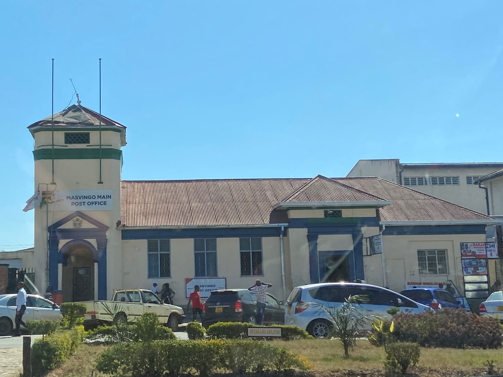
A low colonial-era post office with a green-trimmed corner tower and corrugated roof, cars and people in front under a clear blue sky

Great Zimbabwe, Masvingo & the Midlands, Zimbabwe

Masvingo

The main post office on the central street of Masvingo, the town founded in 1890 as Fort Victoria. (Fritz Joubert / Wikimedia Commons · CC BY-SA 4.0)

A provincial capital on the highway between Harare and the South African border, founded by the Pioneer Column in 1890 as Fort Victoria and renamed in 1982. It is the base for Great Zimbabwe, the stone-walled capital of a medieval kingdom that gave the country its name, and for Lake Mutirikwi in the granite hills to the south-east.

Neighbourhoods

  • The town centre
    • First-time visitors
    • Close to public transport
    • Shops and banks

    A compact grid of low colonial-era buildings, shops, banks and offices along the main street, with the long-distance bus stops and the highway running through. Most of the town's hotels, the market traders and the daily business of the province are within a few blocks.

    Open in Maps
  • Mucheke
    • Local life
    • Markets
    • Music and nights out

    The oldest township, laid out in the colonial period on the far side of the Mucheke River from the centre. It is densely built and busy, with the main bus terminus, small bars and takeaways, and market stalls selling vegetables, maize and second-hand clothes.

    Open in Maps
  • Rujeko and Runyararo
    • Quiet and residential
    • Local life

    Post-independence high-density and medium-density suburbs east and south of the centre, rows of small houses with yards, tuckshops on the corners and schools and churches between them. There is little for visitors beyond a sense of how the town actually lives.

    Open in Maps
  • The Great Zimbabwe and lake road
    • Scenery
    • Lodges and camping

    The road running south-east from the town towards the ruins and Lake Mutirikwi passes through granite hills and msasa woodland. Lodges, campsites and the site hotel are strung along it, and much of the area is farmland and small ranches.

    Open in Maps

Things to do

The stone city

  • Great Zimbabwelandmark

    The mortarless granite ruins about 25 kilometres south-east of the town — the Hill Complex on its ridge, the Great Enclosure with its conical tower, and a site museum of finds from the ruins; a UNESCO World Heritage Site since 1986.

    Open in Maps

The lake and the bush

  • Lake Mutirikwipark

    A reservoir filling a valley among granite hills about 30 kilometres from town, created by a dam completed in 1960, with a recreational park on its northern shore.

    Open in Maps
  • Masvingo Airporttransit hub

    The town's small airport, with its runway about three kilometres east of the centre, used mainly by small chartered aircraft and by military flights.

    Open in Maps

In and around the town

  • Great Zimbabwe Universityattraction

    A state university named for the ruins, which grew out of Masvingo State University in the 2000s and has campuses in and around the town, including the law school and library in the centre.

    Open in Maps
  • Mucheke marketmarket

    The produce and second-hand market beside the main bus terminus in Mucheke, where vegetables, grain, dried fish and clothing are traded.

    Open in Maps
  • The Italian memorial churchlandmark

    A memorial church near the town built during the Second World War, when a camp at Fort Victoria, as Masvingo was then called, held Italian prisoners and internees.

    Open in Maps

Eat and drink

Long-standing places and food districts in Masvingo. Hours, ratings and directions come from your maps app, always current.

Masvingo classics

  • Sadza and relishrestaurant

    The daily plate across the province: stiff maize-meal sadza with muriwo greens, beans, dried fish or a stew of beef or goat, often thickened with peanut butter.

    Open in Maps
  • Road runner chickenrestaurant

    Free-range village chicken, slow-cooked into a rich stew and prized above commercial broiler meat; it appears on the menu of most sit-down places in town.

    Open in Maps
  • Madoramarket

    Mopane worms, dried and then fried until crisp, sold by the cup at the markets and eaten as a relish or a snack.

    Open in Maps

Markets and food streets

  • The town centre takeawaysneighborhood

    The main street and the blocks around the bus stops are lined with bakeries, grills and takeaway counters serving chicken and chips, meat pies and sadza plates to travellers breaking the Harare–Beitbridge run.

    Open in Maps
  • Mucheke market stallsmarket

    Vegetables, tomatoes, maize, groundnuts and roasted maize cobs sold from stalls and braziers beside the terminus, with maheu and Chibuku drunk nearby.

    Open in Maps

Experience Masvingo

History

The stone-walled city in the hills south-east of the present town was the capital of a Shona state that traded gold and ivory to the Indian Ocean coast between about the eleventh and fifteenth centuries; when it declined, the surrounding Karanga chieftaincies remained on the land. In 1890 the Pioneer Column, sent north by Cecil Rhodes's British South Africa Company, halted here and built Fort Victoria, making it the oldest colonial settlement in what became Southern Rhodesia. The Old Fort that still stands in the centre of the town was erected in 1891, one of a series of posts guarding the route south from Salisbury.

The fort became a trading and administrative centre for a farming and ranching district, and a base for the diggers and treasure hunters who looted the ruins in the following decades, prompting the first scientific excavation in 1905–06. The railway went elsewhere — to Gweru, Kwekwe and Bulawayo — so Fort Victoria grew slowly, its importance resting on the road south towards the Limpopo and on the land around it. The Mutirikwi dam, completed in 1960, was built to water the sugar estates of the lowveld, and created the lake beside the ruins.

The town saw guerrilla activity in the liberation war of the 1970s, and at independence in 1980 the country took its name from the ruins. In 1982 Fort Victoria was renamed Masvingo, which means "fort" in Shona, and the province around it took the same name. Since then it has become a provincial capital and a university town, while the economic crises of the 2000s and after have pushed much of its trade into the informal sector and many of its young people to South Africa, a few hours down the same highway.

Culture & Customs

Masvingo is the heart of Karanga country, the southern dialect of Shona, and the area around the ruins is treated as a spiritual centre as much as an archaeological one: the hills are associated with ancestral spirits, and traditional leaders retain a voice in what happens at and around the site. The soapstone birds excavated there became the national emblem, and the town trades on that association in its name, its university and its symbols.

Mission Christianity is deeply rooted. The Reformed mission at Morgenster near the ruins, with its teachers' college, and Catholic schools and colleges such as Bondolfi built a tradition of boarding education that still draws pupils from across southern Zimbabwe, and apostolic churches in white robes gather in the open on the edges of town at weekends. Sunday is quiet in the centre and busy in the townships.

Cultural life is small-town and sociable: church and school choirs, sungura and gospel from bars and kombis, football on dusty grounds, and family gatherings where lobola negotiations and funerals draw relatives back from Harare and Johannesburg. Stone sculpture and curio carving are worked in the district for visitors to the ruins. Greetings are formal and unhurried, respect for elders is expected, and English is understood in the shops and offices while Karanga is the language of the street.

Daily Life

Masvingo is a middle-sized Zimbabwean town, well short of Harare or Bulawayo in scale, whose population is swelled in term time by students at Great Zimbabwe University and the teacher-training and technical colleges. Most residents live in the high-density suburbs — Mucheke, the oldest, and the newer Rujeko and Runyararo — and walk or take a kombi into the centre.

The economy rests on government offices, the province's schools and colleges, retail and transport along the Harare–Beitbridge highway, and the farms and cattle ranches around the town; tourism at the ruins adds a smaller share. As elsewhere in the country, a large informal sector of vendors, tuckshops and cross-border traders absorbs those without formal work, and remittances from relatives in South Africa support many households.

The day starts early, with queues at the bus terminus and vendors setting out before dawn. Power cuts are a routine part of life, so generators and solar panels run shops and homes; water supply is intermittent in parts of town. The province has suffered repeated droughts, including a severe one in 2024, which raise food prices and drive rural families into the town to trade. The currency situation — most trade in US dollars, with the ZiG alongside — makes small change a daily preoccupation.

Food

Sadza, the stiff maize-meal porridge, is the foundation of nearly every meal, eaten by hand with a relish: muriwo, the leafy greens of covo, rape or pumpkin, cooked down with tomato and onion and often finished with peanut butter; beans; matemba, small dried fish from the lakes; or a stew of beef or goat. Cattle country around the town makes beef common, and a braai of meat over coals is the standard for a celebration.

The prized dish is road runner — free-range village chicken, tougher and far more flavourful than commercial broiler, simmered slowly with tomato and onion. From the mopane woodlands to the south come madora, mopane worms, dried and fried crisp and eaten as a relish or a snack; baobab fruit pulp, dry and tart, is sold in season. Groundnuts appear everywhere, in relish, in rice cooked with peanut butter, and roasted in paper cones.

Street food is straightforward: maputi, puffed maize, sold by the bag; roasted maize cobs over braziers; freshly fried mazondo or boiled offal at the terminus; and bakery bread and meat pies for travellers on the highway. To drink there is maheu, the thick non-alcoholic fermented maize drink, sour milk taken with sadza, Chibuku sorghum beer in cartons in the bars of Mucheke, bottled lagers, and Mazoe orange cordial mixed with water at home.

Planning tools

Budget

Masvingo is one of the cheaper bases in Zimbabwe. Guesthouses in the town are inexpensive, market food costs little, and the main expense is reaching Great Zimbabwe and the lake, which means a hire car, a taxi or a lodge transfer. Lodges along the ruins road cost considerably more than rooms in the centre.

Daily Budget Midrange
USD 100–250 (lodge or the site hotel, restaurant meals, car hire and a guided visit to the ruins)
Daily Budget Shoestring
USD 35–60 (guesthouse or campsite, market food and sadza plates, kombis and buses, site entry)

Carry small, clean US dollar notes, since change is a constant problem and cards are of limited use outside the larger hotels.

Best Time to Visit

April to October is the most comfortable stretch, with dry, clear weather for walking the ruins and the lake shore; June and July mornings are cold. The rains from November to March green the hills and fill the lake, but afternoons bring storms and the heat builds through October.

Suggested Number of Days

A day or two covers the town and the ruins. Three or four allow time for the lake, the hills around it and slower travel by bus, and anyone continuing to the lowveld will want longer. Without a vehicle, everything takes more time than the distances suggest.

First Visit
1–2 days
With Surroundings
3–4 days

Transportation

The town centre is small enough to cross on foot, and kombis (minibuses) run between the centre, Mucheke and the residential suburbs for a few cents. There is no public transport to the ruins or the lake: visitors use a hire car, a taxi arranged for the day, or a lodge transfer. Long-distance coaches on the Harare–Beitbridge route stop in the town.

Agree a taxi fare for the round trip to Great Zimbabwe before setting off, and allow for waiting time at the site.

Airport & Station Connections

Masvingo sits on the main highway between Harare and the Beitbridge border with South Africa, about 290 kilometres south of the capital and roughly four hours by road. Buses and coaches on that route, and on the road west to Bulawayo, are how most people arrive. The town has a small airport used mainly by charter and military aircraft, so visitors flying in use Harare and drive.

Walkability

The centre is walkable: a handful of straight streets with shops, banks and offices, crossed in a quarter of an hour. Pavements are uneven in places and the highway traffic through town is heavy with trucks. Mucheke is a walk or a short kombi ride across the river. Everything beyond the town, including the ruins, needs a vehicle.

Safety

The town is generally calm, and the usual concerns are petty theft in the market and around the bus terminus and the risk of the highway itself, which carries heavy truck traffic and is dangerous after dark. Police roadblocks are common on the roads in and out. Power cuts are frequent, leaving streets unlit at night.

Take malaria precautions in the low-lying areas, avoid political gatherings, don't drive at night, keep documents and small change ready for roadblocks, and don't swim in still fresh water outside managed sites. Check current official travel advice before travelling.

Climate

Masvingo lies a little below the highveld, so it is warmer than Harare and drier than the east. Summer, from December to February in the southern hemisphere, is warm and wet; winter is dry and sunny with cold nights. Drought is a recurring problem across the province, as in 2024.

Summer
warm and wet, with days around 27–30°C and afternoon thunderstorms
Winter
dry and sunny, days around 22–25°C with nights that can fall close to freezing

Local Customs

This is Karanga-speaking country, a dialect of Shona, and greetings come before any transaction; an older person is greeted first and often with both hands or a slight bow. Great Zimbabwe is regarded as a spiritual place as well as a monument, and guides ask that walls are not climbed on and that behaviour at the site is quiet and respectful. Dress in town is modest and neat.

Ask before photographing people, market stalls or houses, and do not photograph police, roadblocks, soldiers or government buildings. Tipping is not obligatory but guides and drivers appreciate a small amount in US dollars.

Common Payment Methods

The US dollar is used for most transactions in practice, alongside the gold-backed ZiG introduced in 2024. Cash is what works: bring clean, recent dollar notes in small denominations, because change is scarce. Cards are accepted at the larger hotels and some fuel stations, mobile money is widespread among residents, and ATMs are unreliable.