Flat-roofed red-brown houses and ruined walls of a desert town, seen from above with sandy hills beyond

Mauritania

The Senegal River & the South

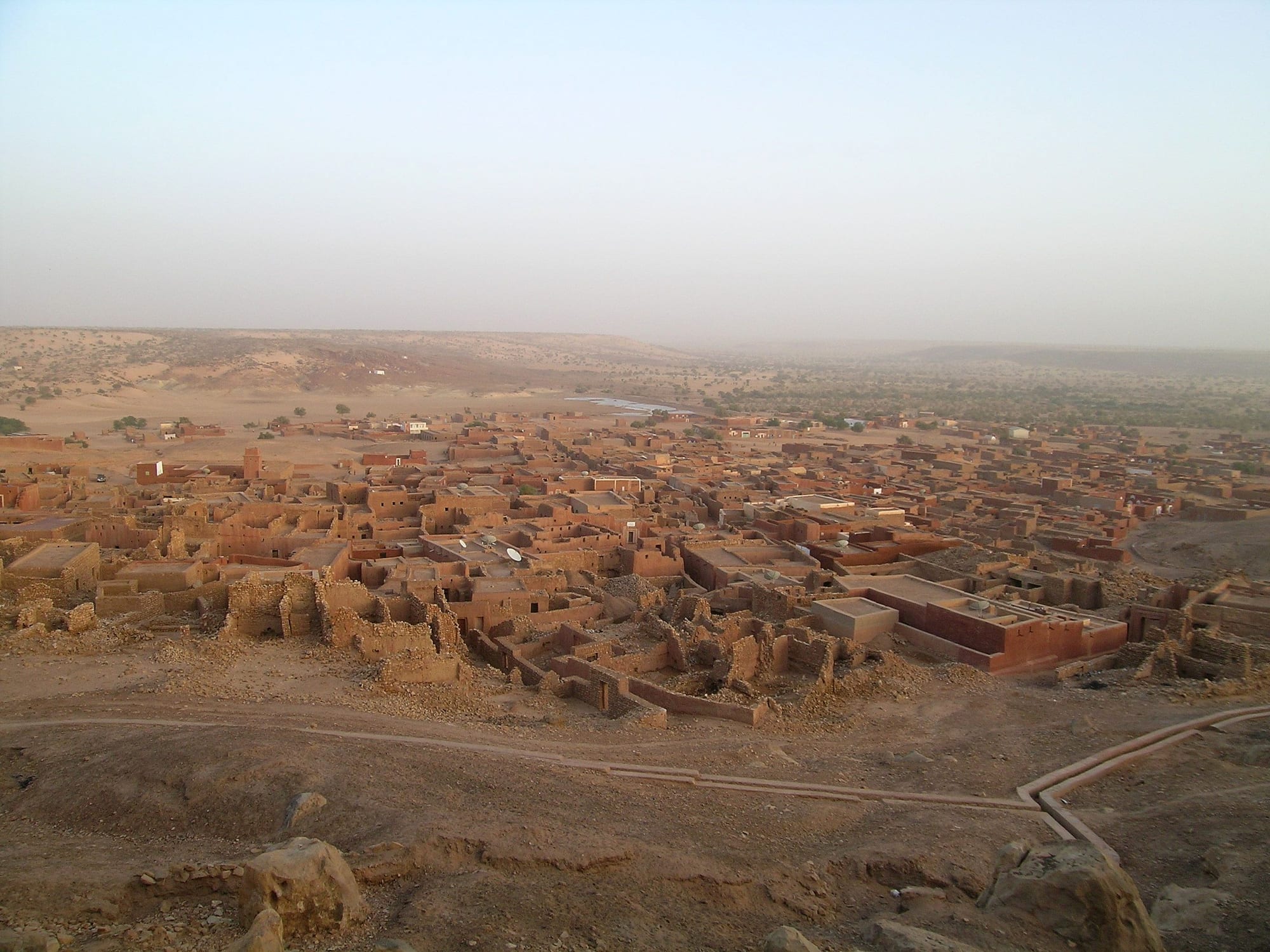
The old caravan town of Oualata in Hodh ech Chargui, seen from the air. (c.hug / Wikimedia Commons · CC BY-SA 2.0)

Mauritania's Sahelian south, stretching from the farmed floodplain of the Senegal river at Kaédi and Boghé across Assaba and the Hodh plains to Néma and Oualata near the Malian border — the country's greenest land, home to its Afro-Mauritanian peoples and to the ruins of the medieval trading cities of Ghana.

Explore The Senegal River & the South

History

The Hodh and its cliffs were settled long before the Sahara reached its present extent: stone-walled villages along the escarpments of the Dhar Oualata and Dhar Néma were built by farming and herding communities from around 2000 BC. The region later lay at the northern edge of the Ghana empire of the Soninke, and the ruins at Koumbi Saleh may be those of its capital. Awdaghust, an important trade town at Tegdaoust in Hodh el Gharbi, was taken by the Almoravids in 1054. Oualata rose as the southern terminus of the caravan route and was visited by Ibn Battuta in the 14th century.

Along the Senegal river, the kingdom of Tekrur and its successor, the Futa Toro of the Halpulaar, ruled both banks; the Islamic revolution of 1776 set up an almamate there. Moorish emirates, Brakna among them, dominated the north bank and traded gum arabic with European merchants.

French forces moved up the river in the 19th century and made the valley part of Mauritania in the early 1900s, drawing the border along the river. After independence, tensions between the Moorish state and the valley's Afro-Mauritanians grew, and in 1989 a crisis with Senegal led to the expulsion of many black Mauritanians across the river. The droughts of the 1970s and 1980s emptied much of the Hodh's pastures. Since 2012 the Mbera camp near Bassikounou has sheltered refugees from the war in Mali.

Culture & Customs

The river valley is the heartland of Mauritania's Afro-Mauritanian peoples. Halpulaar (Toucouleur and Fulani) communities dominate around Kaédi and Boghé, speaking Pulaar and tracing their identity to the Futa Toro; the Soninke of Guidimaka, heirs to the Ghana empire, are known for their emigration, and many villages are sustained by relatives in France. Wolof is spoken towards the delta. Further north and east, in Brakna, Assaba and the Hodh, Moorish Bidhan and Haratin herding and farming communities predominate, speaking Hassaniya.

Oualata is famous for its house decoration: women paint doorways, niches and inner walls with decorative motifs, renewed after each rainy season. Kiffa gave its name to beads of powdered glass made by women to secret recipes, a craft now almost lost.

Religious life follows Sufi brotherhoods, the Tijaniyya and Qadiriyya, and the Quranic schools of the valley and the Hodh have trained scholars for centuries. The memory of 1989, the question of land along the river, and the lasting legacy of slavery shape local politics, and the relationship with Senegal, across the water, remains close and personal, with families spread over both banks.

Daily Life

This is Mauritania's farming region. Kaédi, the capital of Gorgol, is the largest river town, with Boghé, Aleg, the capital of Brakna, and Sélibaby in Guidimaka; Kiffa, Ayoun el Atrous and Néma are the market towns of the interior, spread along the Route de l'Espoir.

The river valley grows irrigated rice on large schemes and, as the flood recedes, sorghum, maize, beans and vegetables on the damp soils of the walo, the floodplain. Dams built by the countries sharing the river, at Diama and Manantali, now regulate its flow. Further east the economy rests on livestock: herds of cattle, sheep, goats and camels move between wells and pastures, and animals are driven or trucked to markets as far as Senegal. Remittances, particularly from France to Guidimaka, keep many villages going.

Life is rural and organised around the season: planting when the rains come, the harvest in autumn, and the long dry season when men often leave for work in Nouakchott or abroad. Water shortages, poor roads, drought and the arrival of refugees and herders from Mali are constant pressures.

Food

The river valley eats like its neighbours in Senegal and Mali. Rice with fish and vegetables in tomato sauce is the midday meal, and millet is steamed into a fine couscous, eaten with meat or vegetable sauce, or cooked into a thick porridge with soured milk. Mafé, a stew of meat in groundnut sauce, is common, and fish from the Senegal river is grilled, fried or dried for the lean months.

In the Moorish areas of Brakna, Assaba and the Hodh, the diet is based on milk and meat: fresh and soured milk, zrig, the fermented-milk drink, goat and mutton stews with rice or millet couscous, and camel meat. Méchoui, a whole roast lamb, marks weddings and Eid al-Adha, when every family that can afford it slaughters a sheep.

Wild foods matter in the Sahel: the leaves and fruit of the baobab are used in sauces and drinks, and hibiscus flowers are brewed into a cold red drink. Green tea with mint, brewed three times, is served everywhere.

Attractions & Natural Wonders

Kaédi sits on the Senegal river in a plain of rice fields, with a lively market and a regional hospital of brick domes by Fabrizio Carola, and villages of the Halpulaar lie along the banks upstream and down. Rosso, the ferry town downstream where the main road crosses into Senegal, lies administratively in neighbouring Trarza. Aleg, the capital of Brakna, lies on Lake Aleg.

In Assaba, Kiffa is a busy crossroads market town known for its glass beads. To the south, the Sahel villages of Guidimaka cluster around Sélibaby in a landscape of low hills, gum trees and millet fields that turns green in the rainy season.

To the east lie the Hodh plains, a vast country of sand and scrub crossed by camel herders. Néma, at the end of the paved road, stands below the escarpment of the Dhar Néma, and from there a track leads to Oualata, a UNESCO World Heritage Site with painted houses and a manuscript museum. The ruins of Koumbi Saleh south of Timbédra and of Tegdaoust in Hodh el Gharbi recall the medieval trade across the Sahara.

Cities in The Senegal River & the South

Planning basics

Budget

The south is cheap but offers little comfort: towns such as Kaédi, Kiffa, Aleg, Ayoun el Atrous and Néma have simple hotels and auberges, and the villages have none. Transport by bush taxi along the main road is inexpensive, but reaching Oualata or the Guidimaka villages needs a hired 4x4, which is the main cost.

Daily Budget Midrange
USD 75–170 (best hotel in town, a hired 4x4 and driver)
Daily Budget Shoestring
USD 20–35 (auberge, market food, bush taxis)

Bring enough cash from Nouakchott; cash machines outside the capital are few and unreliable.

Safety

The river valley and the main towns are generally calm, but most governments advise against travel to the areas bordering Mali and to much of the east and south-east, including large parts of the Hodh, because of the risk of terrorism and kidnapping. Four French visitors were killed near Aleg in 2007. The conflict in Mali has spilled over the border, and night driving on the main highway is dangerous.

Stay off the roads near the Malian border, travel with a local driver, and do not drive after dark. Check current official travel advice before travelling.

Climate

This is the Sahel rather than the Sahara. A rainy season from about July to September greens the land, and rain increases towards the south-east, with parts of Guidimaka receiving over 600 millimetres a year. The Senegal floods its plain after the rains. April to June is fiercely hot inland, often above 45°C at Kiffa and Néma, and dusty harmattan winds blow in winter.

Summer
very hot and humid, 35–45°C, with storms and rain from July to September
Winter
dry and warm, 28–33°C by day, with cool nights and harmattan dust

Transportation

The Route de l'Espoir, the paved highway from Nouakchott, runs east through Aleg, Kiffa and Ayoun el Atrous to Néma, a journey of well over 1,000 kilometres, and a separate paved road follows the river valley to Boghé and Kaédi. Bush taxis and buses serve the main road; the villages, Oualata and the ruins need a 4x4. Small ferries cross the Senegal river to Senegal.

Travel by day only; expect many police and gendarmerie checkpoints, and keep copies of the passport to hand.

Best Time to Visit

November to February is the most comfortable season, with the land still green after the rains, the river valley harvesting and the heat bearable. The rainy season makes dirt roads difficult, and May and June are the hottest months.