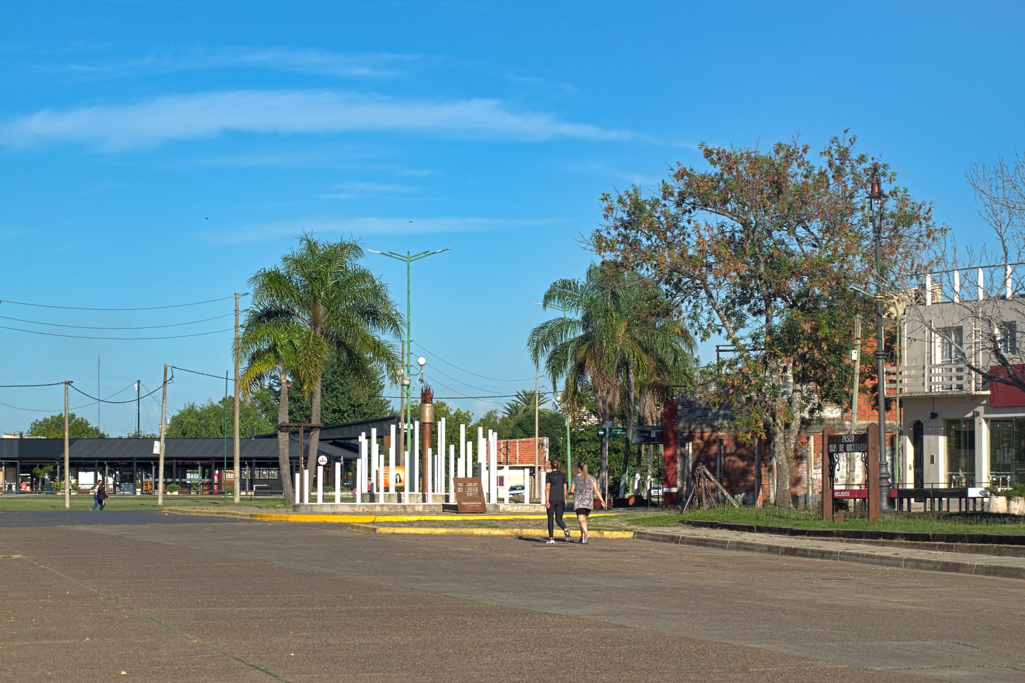
A wide paved waterfront street in Gualeguaychú with palm trees, a white-columned monument and low brick buildings under a blue sky

Córdoba & the Pampas, Argentina

Gualeguaychú

The costanera, the riverside avenue of Gualeguaychú, in March 2024. (Ezarate / Wikimedia Commons · CC BY-SA 4.0)

A river city in the south-east of Entre Ríos, on the Gualeguaychú River near its meeting with the Uruguay and about 230 km from Buenos Aires. Founded in 1783 as a colonial outpost, it grew as a port and farming town and is now known for the summer carnival parades of its corsódromo, its river beaches and hot springs, and the bridge to Fray Bentos in Uruguay.

Neighbourhoods

  • Centro
    • First-time visitors
    • Historic district
    • Shopping

    The grid laid out around Plaza San Martín, the old main square, with the San José Cathedral, the main shopping street, 25 de Mayo, and the town hall on Plaza Urquiza.

    Open in Maps
  • The costanera
    • River views
    • Best for food
    • Summer evenings

    The riverside avenue along the Gualeguaychú River, with the old port, restaurants, bars and the city's river beaches, busiest on summer evenings.

    Open in Maps
  • Unzué Park and the far bank
    • Parks
    • Beaches
    • Camping

    Across the old Méndez Casariego bridge, a large park of about 120 hectares with a lagoon, near Pueblo General Belgrano and its hot springs.

    Open in Maps

Things to do

The carnival and the town

  • Corsódromoattraction

    The parade ground built for the carnival and opened in 1997, where the comparsas parade their floats and costumes on summer Saturday nights before crowds of some tens of thousands.

    Open in Maps
  • San José Cathedrallandmark

    The city's cathedral, designed by the Swiss architect Bernardo Poncini, begun in 1863 with Urquiza as godfather and opened in 1890; its towers were replaced by domes in 1959.

    Open in Maps
  • Plaza San Martínpark

    The original main square of the 1783 town, at the heart of the old centre.

    Open in Maps
  • Palacio Clavarinolandmark

    A heritage building that houses the Colegio Luis Clavarino, founded in 1905.

    Open in Maps

The river and the parks

  • The costanera and the river beachesbeach

    The riverside avenue and the string of beaches along the Gualeguaychú River, such as the municipal beach and the Playa del Puente, busy throughout the summer.

    Open in Maps
  • Unzué Parkpark

    A park of about 120 hectares with a lagoon on the far bank of the river, laid out in the 1920s and reached by the Méndez Casariego bridge.

    Open in Maps
  • Isla Libertadpark

    The island in the river opposite the city, where Urquiza gathered his Ejército Grande before the campaign against Rosas.

    Open in Maps
  • Ñandubaysalbeach

    A beach and campsite on the Uruguay River east of the city, known for its mineral-rich sand.

    Open in Maps
  • Termas del Guaychúattraction

    A hot-spring complex outside the city with naturally heated pools of up to about 40°C.

    Open in Maps

Short trips from the city

  • Libertador General San Martín Bridgelandmark

    The cantilever road bridge of 1976 across the Uruguay River between Puerto Unzué and Fray Bentos, more than 5 km long with its approaches.

    Open in Maps
  • Fray Bentosattraction

    The Uruguayan river port across the bridge, whose historic meatpacking plant is a UNESCO World Heritage Site; a passport is needed to cross.

    Open in Maps

Seasonal events

  • Carnaval del Paísevery Saturday in January and February and the first Saturday of March

    Considered the largest open-air show in Argentina, a carnival parade in which the comparsas of the city's clubs — among them Marí Marí, Papelitos, O'Bahía, Ará Yeví and Kamarr — compete with floats, costumes and music in the corsódromo.

Eat and drink

Long-standing places and food districts in Gualeguaychú. Hours, ratings and directions come from your maps app, always current.

Gualeguaychú classics

  • River fishrestaurant

    Surubí, boga and other fish from the rivers of Entre Ríos, grilled, fried or cooked in chupín, a fish stew.

    Open in Maps
  • Parrillasrestaurant

    Grill restaurants serving beef, chorizo and morcilla in the Argentine way.

    Open in Maps

Food districts

  • The costaneraneighborhood

    Restaurants, bars and ice-cream parlours facing the river, the city's place to eat out on summer evenings.

    Open in Maps
  • Calle 25 de Mayoneighborhood

    The main commercial street of the centre, with cafés and bakeries.

    Open in Maps

Experience Gualeguaychú

History

The Chaná and Charrúa lived along these rivers before the Spanish. From the 17th century the authorities in Santa Fe and Buenos Aires granted land here to ranchers, whose settlements were in constant conflict with the native peoples, who had been decimated by killings and enslavement by the mid-18th century. The name comes from the river; a priest's record of 1715 derives it from a Guaraní expression meaning "big-water river".

A chapel settlement existed in the area by 1770. In 1782 the viceroy sent the officer Tomás de Rocamora to gather the scattered settlers and strengthen the Spanish presence against Portuguese incursions, and on 18 October 1783 he founded San José de Gualeguaychú, moving the town to higher ground opposite Libertad Island and marking out 85 plots. In the civil wars the town was sacked in 1845 by forces under Giuseppe Garibaldi, and Justo José de Urquiza gathered his Ejército Grande on the island before his campaign against Rosas.

A port, cereal mills and a railway station brought growth, and the population reached about 18,000 by 1914. In the 1920s Unzué Park was laid out across the river, a bridge was built and a costanera added along the bank. The Libertador General San Martín Bridge to Fray Bentos opened in 1976. From 2005 residents opposed to a large pulp mill being built near Fray Bentos blocked the bridge, at times for weeks, in a dispute that went to the International Court of Justice; it ruled in 2010 that Uruguay had failed to inform Argentina but had not polluted the river, and the two countries then agreed joint monitoring.

Culture & Customs

The city's identity is its carnival, which it calls the Carnaval del País, the carnival of the country. Every Saturday in January and February and on the first Saturday of March, the comparsas — troupes belonging to local clubs, such as Marí Marí, Papelitos, O'Bahía, Ará Yeví and Kamarr — parade their floats, costumes and drummers through the corsódromo, opened in 1997. Each spends a large sum preparing for the season, and they compete for a share of the ticket money; the weakest drops out for the next year. Work on costumes and floats goes on for months, and the whole city follows the result.

Entre Ríos is chamamé and carnival country, and the river is the other centre of local life: fishing, rowing and sailing clubs, beaches, and the evening walk on the costanera. The pulp-mill dispute of the 2000s gave the city a national reputation for environmental activism, carried by its Citizens' Environmental Assembly.

The city's people are largely of Spanish, Italian, German, French and Arab immigrant descent, and Gualeguaychú keeps the habits of a provincial riverside town: siestas in summer heat, mate shared in the squares and football at the local clubs.

Daily Life

The 2022 census counted about 95,000 people in Gualeguaychú, making it one of the largest cities in Entre Ríos. In summer the population swells: the city receives up to about 400,000 visitors over the season, most from Buenos Aires and its province, with a growing number from Santa Fe and Córdoba.

The economy combines tourism with farming and industry. The surrounding countryside raises cattle and grain, and the city's industrial park, the largest in the province, holds more than 60 companies. Shops, services and the hospitality trade employ much of the rest, and the carnival itself is a sizeable local business.

Most people live in low houses on a grid spreading out from the centre and along the river. Summer days start early and stop for a long siesta, with life returning in the evening on the costanera and the beaches. The bridge to Uruguay and Route 14, the road from Buenos Aires to Brazil, make the city a crossing point, and questions about the river and the mill across it remain a local concern.

Food

The rivers set the menu. Fish from the Gualeguaychú, the Uruguay and the Paraná — surubí, a large catfish, along with boga and dorado — are grilled whole, fried or cooked in chupín, a fish stew, and riverside restaurants and fishing clubs are the places to try them. Weekend asado, with beef, chorizo and morcilla, is the other ritual, at home and in the parrillas.

Entre Ríos is known for its citrus, and oranges and mandarins from the province are sold everywhere in season. Bakeries sell facturas and medialunas for breakfast and merienda, empanadas are standard, and the ice-cream parlours of the costanera and the centre are busy on summer nights.

Carnival Saturdays shape the eating week in summer, with late dinners in the centre and on the costanera before or after the parade, and restaurants busy well past midnight. Mate accompanies everything, from the squares to the river beaches, and a thermos and gourd are part of every day out at the balnearios and campsites along the river.

Planning tools

Budget

Gualeguaychú is cheaper than Buenos Aires for most of the year, but carnival Saturdays and the January holidays bring the highest prices and full hotels, and carnival tickets are an extra cost. Campsites, cabañas and the hot-spring complexes give a range of options.

Daily Budget Midrange
USD 80–150 (hotel or cabaña, parrilla or river-fish dinners, a carnival ticket or a day at the hot springs)
Daily Budget Shoestring
USD 35–60 (campsite or simple hostel, bakery and set-menu meals, local buses)

Book rooms well ahead for carnival weekends, and treat all peso prices as provisional.

Best Time to Visit

The carnival runs on Saturdays from January to early March, and summer is also the season for the river beaches. Spring and autumn are quieter and pleasant for the costanera and the parks, and the hot springs work all year, including in the cool, damp winter.

Suggested Number of Days

A night or two covers the city, timed around a carnival Saturday in summer. Allow three or four days for the hot springs, the beaches on the Uruguay River and a crossing into Uruguay.

First Visit
1–2 days
With Surroundings
3–4 days

Transportation

The centre and the costanera are walkable, and local buses and taxis reach the rest of the city. A car is the easiest way to the hot springs, Ñandubaysal and the bridge to Uruguay, though buses run to the main complexes in season.

Taxis and remises are the simplest way back from the corsódromo late at night.

Airport & Station Connections

Most visitors come by road on National Route 14 from Buenos Aires, about 230 km away — around three hours by car or long-distance bus to the bus terminal in the south-west of the city. Gualeguaychú Airport lies 6 km west of the city. The Libertador General San Martín Bridge leads to Fray Bentos in Uruguay.

Walkability

The flat grid of the centre and the costanera are easy to walk, with shady squares and the river close by. The corsódromo, the hot springs and the beaches outside town need transport, and summer heat makes midday walks hard.

Safety

Argentina is relatively safe by regional standards, and violent crime against visitors is uncommon. Gualeguaychú is a calm provincial city; the main risks are pickpockets and bag theft in the carnival crowds, the river's currents and the summer heat. Heavy rain can fall in short bursts — the city holds the Argentine record for rainfall in a single day.

Swim only at beaches with lifeguards, keep valuables close in carnival crowds, and drink plenty of water in summer. Check current official travel advice before travelling.

Climate

Humid and warm, with about 1,200 mm of rain a year. The seasons are those of the southern hemisphere — summer is December to February.

Summer
hot and humid, with temperatures reaching 35°C or more
Winter
mild days and chilly nights, which can fall to around 0°C

Local Customs

The carnival is a matter of club loyalty: each comparsa represents a local club, and families support theirs from year to year. Life follows the Argentine rhythm of long lunches, a quiet siesta in summer, evenings on the costanera and late dinners. Friends greet each other with a kiss on the cheek, and mate is shared everywhere.

A tip of about 10 per cent is usual in restaurants. Spectators at the corsódromo dress for the heat and a long night.

Common Payment Methods

The currency is the Argentine peso. Cards and bank transfers are widely accepted, and the centre has cash machines; carry cash for stalls and small purchases. Uruguayan pesos are used across the bridge, and some US dollars in good condition are a useful backup.