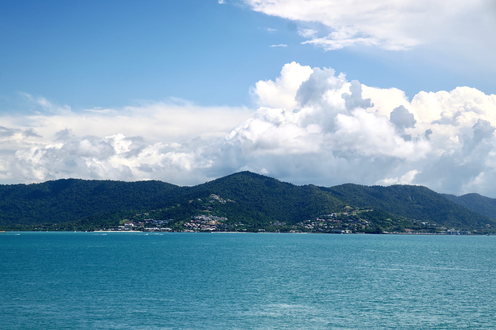
A small town spread along the foot of steep forested hills above turquoise water, under tall white clouds

Queensland, Australia

Airlie Beach

Airlie Beach seen from the water, at the foot of the hills on the Whitsunday coast. (Richard N Horne / Wikimedia Commons · CC BY 4.0)

Airlie Beach is a small resort town on the Whitsunday coast of central Queensland, and the mainland base for trips out to the Whitsunday Islands and the Great Barrier Reef. Sailing boats, dive operators and hostels line one short main street above a public swimming lagoon, built because stingers make the sea unsafe in summer.

Neighbourhoods

  • The main street and the foreshore
    • First-time visitors
    • Nightlife
    • Close to the boats

    Shute Harbour Road runs for a few hundred metres above the water, packed with tour desks, bars, hostels, cafés and dive shops. Below it the foreshore park holds the swimming lagoon, barbecues and a stage. Almost every boat trip is booked and boarded within a short walk of it.

    Open in Maps
  • The marinas and Port of Airlie
    • Sailing trips
    • Waterfront dining
    • Island ferries

    Two harbours bracket the town: a large marina on the western side, full of charter yachts and dive boats, and the Port of Airlie terminal a few minutes from the main street, where island ferries load. Both have restaurants and cafés looking over the moorings.

    Open in Maps
  • Cannonvale
    • Quiet and residential
    • Better value
    • Shops

    The larger residential town about three kilometres west, where most locals live and shop. It has the supermarkets, the shopping centre and the sports grounds, along with cheaper flats and motels and a long stretch of beach and parkland linked to Airlie Beach by a foreshore path.

    Open in Maps
  • Jubilee Pocket
    • Self-catering
    • Families
    • Quiet and residential

    A pocket of houses and holiday units in the valley just east of the centre, on the road towards Shute Harbour. It is a short drive or a steep walk from the main street, and a common choice for longer stays and for families wanting a kitchen and a car space.

    Open in Maps

Things to do

The foreshore

  • Airlie Beach Lagoonattraction

    A large public swimming lagoon on the foreshore, built so that people can swim safely in the months when marine stingers make the sea risky, with lawns, shade and barbecues around it.

    Open in Maps
  • Bicentennial Walkwaytrail

    A paved coastal path of several kilometres running west from the foreshore past small bays and mangroves to Cannonvale, easy walking with water views most of the way.

    Open in Maps

The islands and the reef

  • Whitsunday Islandsattraction

    A group of seventy-odd continental islands in a sheltered passage offshore, most of them national park, reached by day boats, sailing trips and ferries from the town.

    Open in Maps
  • Whitehaven Beachbeach

    A long beach of very fine white silica sand on Whitsunday Island, with the tidal sand patterns of Hill Inlet at its northern end, and the main target of day trips from the town.

    Open in Maps
  • Hook Islandattraction

    A rugged island north of Whitsunday Island, almost all of it national park, known for the coral along its northern coast and for the Ngaro rock-art site at Nara Inlet.

    Open in Maps
  • Daydream Islandattraction

    A small resort island close to the town, about a kilometre long, with an outdoor aquarium of corals, fish and rays.

    Open in Maps
  • Hayman Islandattraction

    A private island open to the public, known for the luxury resort built there in the 1950s and for the reef close by.

    Open in Maps

Short trips from the town

  • Conway National Parkpark

    The Conway Peninsula east of the town, covered by the largest area of lowland tropical rainforest in Queensland outside the tropical far north, with walking tracks above the Whitsunday Passage.

    Open in Maps
  • Shute Harbourtransit hub

    A sheltered inlet about ten kilometres east, long the main departure point for island ferries, water taxis and seaplanes, with its marine terminal rebuilt in 2021.

    Open in Maps
  • Proserpineneighborhood

    The sugar town on the inland highway, with the district hospital, a working mill and an entertainment centre, and the nearest railway station.

    Open in Maps
  • Bowenneighborhood

    An old port town about an hour north, known for its mangoes, tomatoes and melons, the Big Mango on the highway and the sheltered swimming at Horseshoe Bay.

    Open in Maps

Seasonal events

  • Great Barrier Reef Festivalthe dry season

    The town's own festival, with fireworks on the foreshore, live music from local artists and events along the waterfront.

  • Airlie Beach Festival of MusicNovember

    A music festival spread over several days in venues around the town, at the start of the wet season.

  • Humpback whale seasonthe southern winter

    Humpback whales come into the sheltered Whitsunday waters to calve on their winter migration, and are often seen from island boats.

  • Anzac Daylate April

    Australia's day of remembrance for its war dead, marked on 25 April with a dawn service and a march, as in every Australian town.

Eat and drink

Long-standing places and food districts in Airlie Beach. Hours, ratings and directions come from your maps app, always current.

Food streets and the waterfront

  • Shute Harbour Roadneighborhood

    The main street carries most of the town's eating and drinking — seafood restaurants, pizza and burger places, Asian kitchens, bakeries, coffee shops and the bars that give the town its late nights.

    Open in Maps
  • The marina waterfrontneighborhood

    Restaurants, bars and cafés set among the yacht berths on the western side of town, the usual place for a meal before or after a sailing trip.

    Open in Maps

Nearby

  • Cannonvaleneighborhood

    The neighbouring town has the big supermarkets and the everyday cafés, bakeries and takeaways that residents use rather than visitors.

    Open in Maps

Experience Airlie Beach

History

The Whitsunday Islands are the sea country of the Ngaro people, a seafaring Aboriginal group who crossed the passage in sewn ironbark canoes, quarried stone on the islands and left rock art and shell middens that survive in island caves. James Cook sailed through in June 1770 and named the passage after the church calendar, and for a century afterwards Europeans came for timber, grazing and beche-de-mer rather than for the scenery.

The mainland economy was built inland: sugar cane took over the Proserpine plains from the 1890s, and the coast at Airlie Beach remained farmland and a handful of houses. Tourism arrived by way of the islands, where resorts opened from the 1930s and visitors landed by launch from Shute Harbour, the sheltered inlet east of the town. Airlie Beach grew to serve them, and from the 1980s it grew quickly: bareboat charter fleets, dive schools and hostels turned it into a fixture of the backpacker route up the Queensland coast, and the foreshore was rebuilt with a swimming lagoon so that visitors could swim in stinger season.

Cyclone Debbie made landfall near the town on 28 March 2017 as a severe tropical cyclone, damaging marinas, resorts and much of the tree cover. The rebuild reshaped the waterfront, and the charter fleets and island boats returned. The town remains what it became in the 1980s: a small place whose whole purpose is the water in front of it.

Culture & Customs

Airlie Beach is a sailing town before it is anything else. Masts fill both harbours, crewed day boats and bareboat charters go out on every tide, and the Great Barrier Reef Festival on the foreshore is a fixed point of the local year. Much of the working population is young and transient — crew, dive instructors, bar and kitchen staff, many of them travellers on working visas — which gives the main street a nightlife out of all proportion to the size of the place.

Alongside that runs a quieter family and retirement town in Cannonvale and the valleys behind, with school sport, surf and sailing clubs, fishing and rugby league. Dress is casual to the point of indifference, Queensland keeps its own time with no daylight saving, and the social day is shaped by the boats: early departures, late afternoons back in harbour, sunset on the foreshore.

Ngaro culture is part of how the islands are presented, through the Ngaro Sea Trail of island walks and camps and the rock art at Nara Inlet on Hook Island, and guides are expected to explain the sites rather than let visitors wander them. The 2017 cyclone is still a reference point in conversation, and the health of the reef and the islands is discussed with the directness of people whose livelihoods depend on it.

Daily Life

Airlie Beach itself has only about 1,300 residents. The continuous coastal strip it belongs to — Cannonvale, Jubilee Pocket and the smaller settlements along the bay — holds something over ten thousand, and the wider Whitsunday region about thirty-seven thousand. Cannonvale is where people actually live and shop, and Proserpine, half an hour inland, has the hospital, the mill and the railway station.

The economy is tourism and the trades that support it: charter and dive fleets, boat maintenance and chandlery, hotels, restaurants and tour offices, with sugar cane and cattle inland and market gardens up the coast. That makes the town unusually exposed to the seasons and to the weather. Winter runs at capacity; the wet season empties it, and some businesses close for a few weeks. Staff housing is a standing problem, because so much of the housing stock is let to visitors, and many workers commute from Cannonvale or Proserpine.

Cyclones shape practical life. Building standards are strict, insurance is expensive across northern Queensland, and households keep supplies for the season from November to April. The long-running local arguments are about development on a narrow coastal strip, the pressure of visitor numbers on the islands, and the condition of the reef after repeated coral bleaching.

Food

Seafood is the obvious strength: coral trout and red emperor from the reef, barramundi, mud crab from the mangrove creeks and prawns from the trawlers, sold at the fish co-ops and cooked simply at the marinas and on the foreshore. Fish and chips eaten on the grass by the lagoon is the standard Airlie Beach meal, and many sailing trips cook the day's catch on board.

The country behind and beside the town supplies the rest. Proserpine grows sugar cane, and the Bowen district to the north is known for its mangoes as well as tomatoes, capsicums and melons. Mangoes and lychees come in before Christmas, in the hottest and wettest part of the year.

The main street's menus are a backpacker mix of pizza, burgers, Thai, Japanese, Indian and modern Australian, with several good bakeries and a strong coffee habit inherited from the rest of the country. Queensland's XXXX lager and Bundaberg rum and ginger beer are the local drinks, and a number of Whitsunday bars and restaurants keep a list of Australian wines from much cooler parts of the country.

Planning tools

Budget

Accommodation ranges from the backpacker hostels that made the town's name to resort apartments, so the bed is flexible but the boats are not: a day trip to the islands or a two- or three-night sailing charter is usually the biggest single cost of a visit. Prices climb in the winter dry season and the school holidays and fall sharply in the wet.

Daily Budget Midrange
USD 190–330 (an apartment or hotel room, restaurant meals, one island or reef day trip, a hire car)
Daily Budget Shoestring
USD 70–120 (a hostel dorm, self-catering, the local bus, the foreshore lagoon and the coastal path)

Compare island trips on how long they actually spend at anchor rather than on the total hours; the lagoon, the foreshore park and the walkway to Cannonvale cost nothing.

Best Time to Visit

May to October is the dry season: warm, sunny, less humid, with calmer water for sailing and no marine stingers inshore. The winter school holidays are the busiest and most expensive stretch. From November to April the town is hot and wet, cyclones are possible and stingers keep most people out of the open sea, but prices drop and the islands are quiet.

Suggested Number of Days

Two or three nights are enough for the town and one trip out to the islands. Four to six suit a multi-day sailing charter or a mix of snorkelling, walking and beach days. Weather matters more than anything else here, so an extra day is useful insurance in the wet season.

First Visit
2–3 days
With Surroundings
4–6 days

Transportation

The town centre is walked rather than driven. A local bus service runs along the coast road between Airlie Beach, Cannonvale, Shute Harbour and Proserpine, and hotels and tour operators collect passengers from their accommodation. Ferries and day boats leave from the Port of Airlie terminal and from Shute Harbour, and water taxis and seaplanes serve the islands. A hire car is only really needed for trips inland or up the coast.

The hills behind the main street are steep and the footpaths narrow, so anyone staying above the centre should expect a stiff climb or plan on a taxi.

Airport & Station Connections

Whitsunday Coast Airport, south of Proserpine, is about forty kilometres south-west and has flights from Brisbane, Sydney, Melbourne and Cairns; shuttle buses and taxis meet them for the drive of roughly forty minutes. Hamilton Island, out in the group, has the other airport, connected to the mainland by ferry. Queensland Rail's coastal trains between Brisbane and Cairns stop at Proserpine, and long-distance coaches run along the highway.

Walkability

The flat strip along the water is very walkable: the main street, the foreshore park, the lagoon and the Port of Airlie are all within about fifteen minutes on foot of each other, and the coastal path continues for several kilometres to Cannonvale. The land rises sharply behind the town, so accommodation on the hillsides means steep walking in the heat.

Safety

Crime is low and the risks are mostly natural or nautical. Box jellyfish and Irukandji are present in the sea from about November to May; saltwater crocodiles live in estuaries and creeks along this coast, and there were several shark attacks off Airlie Beach during the 2010s; the cyclone season runs from November to April, and Cyclone Debbie caused severe damage here in 2017. The main street has a concentrated nightlife, with the usual late-night problems that go with it.

Swim in the lagoon or wear a stinger suit in the summer months, take the safety briefing on boats seriously and check the forecast before going out, and follow cyclone warnings in the wet season. Check current official travel advice before travelling.

Climate

Tropical, with a hot wet season from about November to April that brings most of the year's rain, high humidity and the risk of cyclones, and a dry season from May to October that is warm, sunny and much more comfortable. The sheltered passage keeps the sea warm and usually calm.

Summer
hot and humid, generally about 24–31°C, with heavy rain, storms and marine stingers inshore — summer in the southern hemisphere runs from December to February
Winter
warm and dry, generally about 15–25°C, sunny with south-easterly winds, and cooler at night on the water

Local Customs

This is an informal town where swimwear and bare feet are normal on the foreshore and a shirt and sandals count as dressing for dinner. Tipping is not customary in Australia and prices include tax and service. Queensland does not use daylight saving, so evenings get dark early in summer. The islands are the sea country of the Ngaro people, and rock art sites and middens there are protected and should be looked at without touching.

Carry identification if young (the drinking age is 18), respect the marine park rules on anchoring, fishing and feeding fish, and wear sunscreen, a hat and a shirt on the water, where the glare is strongest.

Common Payment Methods

The currency is the Australian dollar. Cards and contactless payment work almost everywhere, including on boats, and some businesses have stopped taking cash. ATMs and banks are on the main street and in Cannonvale's shopping centre. A small card surcharge is common and must be shown.