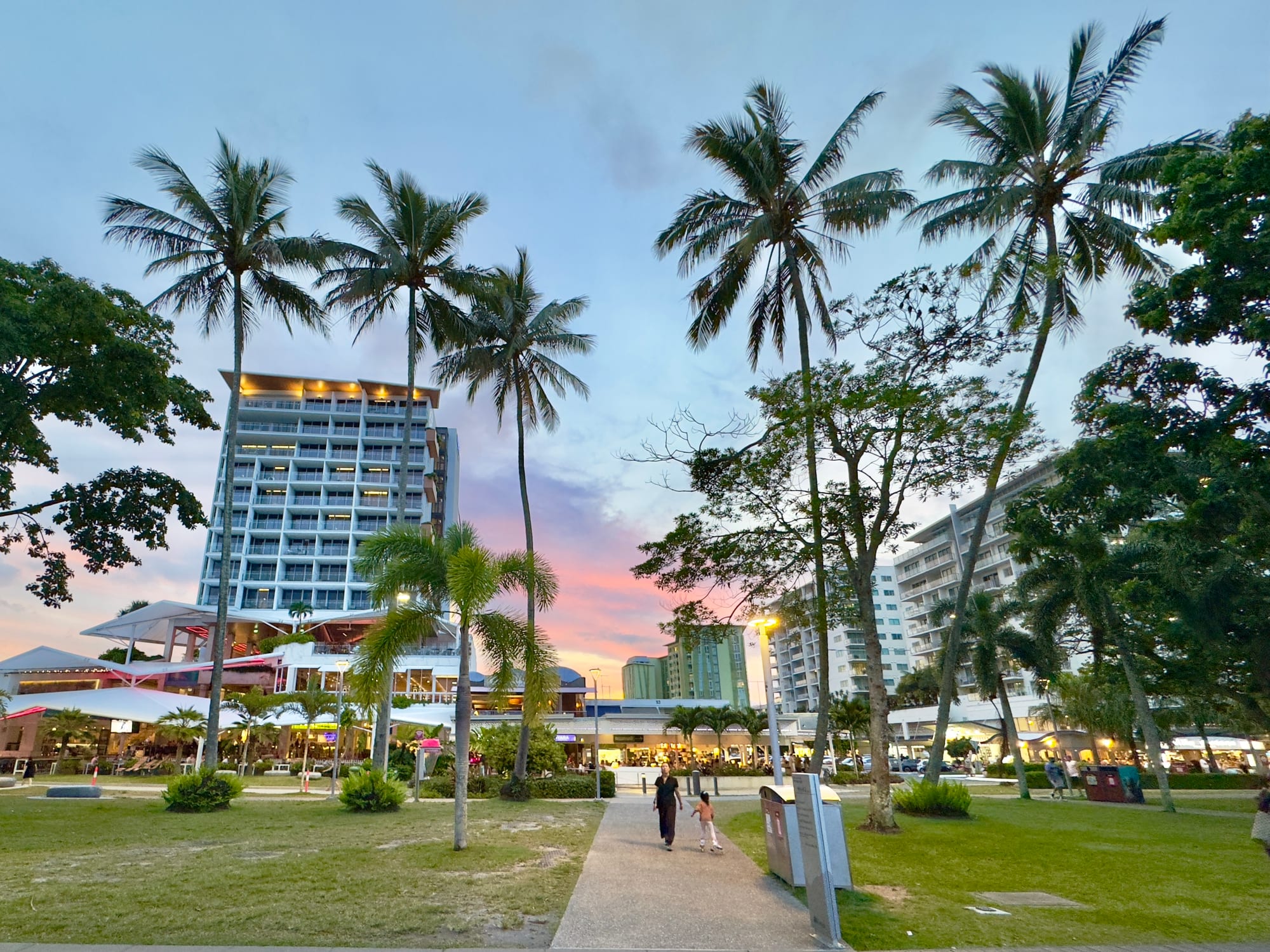
Coconut palms and lawns along the Cairns Esplanade at dusk, with hotel towers and lit restaurants behind

Queensland, Australia

Cairns

Dusk on the Esplanade in central Cairns, looking from the waterfront lawns towards the city centre. (Chris Olszewski / Wikimedia Commons · CC BY-SA 4.0)

The main city of Far North Queensland, on Trinity Bay between rainforested mountains and the Great Barrier Reef. Founded in 1876 as a port for inland goldfields and later built on sugar, it now lives largely on tourism: reef boats leave from its marina, and the Wet Tropics rainforest begins a few kilometres inland.

Neighbourhoods

  • Cairns City
    • First-time visitors
    • Best for food
    • Nightlife

    The compact centre between the Esplanade and the railway, holding most of the hotels, the marina where reef boats leave, the art gallery and the bars and restaurants of Grafton and Spence streets. Everything in it is within a fifteen-minute walk.

    Open in Maps
  • Cairns North and the Esplanade
    • Close to public transport
    • Parks
    • Families

    The strip north of the centre along the waterfront, with the public saltwater lagoon, the boardwalk over the mudflats, playgrounds, barbecues and a run of hotels and apartment blocks facing the water.

    Open in Maps
  • Edge Hill
    • Quiet and residential
    • Gardens
    • Cafés

    An older suburb on the slopes a few kilometres from the centre, built around the botanic gardens and the arts centre in the wartime fuel tanks, with timber Queenslander houses and a small strip of cafés on Collins Avenue.

    Open in Maps
  • Trinity Beach
    • Beaches
    • Families
    • Quiet and residential

    One of the northern beach suburbs about 20 kilometres from the centre, with a sheltered bay, a short esplanade of cafés and restaurants, and a swimming enclosure in the stinger season. Quieter and cheaper than Palm Cove.

    Open in Maps
  • Palm Cove
    • Beaches
    • Resorts
    • Best for food

    The most polished of the northern beaches, about 25 kilometres up the coast, where melaleuca trees line a single beachfront street of resorts and restaurants. Boats leave its jetty for the reef and for Double Island.

    Open in Maps
  • Portsmith and the southern suburbs
    • Local life
    • Value accommodation

    The working side of the city around the inlet and the highway south towards Edmonton and Gordonvale — industrial yards, shopping centres and residential streets where most Cairns residents actually live, with cheaper rooms and local eating places.

    Open in Maps

Things to do

The city and the waterfront

  • Cairns Esplanade and the lagoonattraction

    A waterfront promenade above the tidal mudflats of Trinity Bay, with a free public saltwater swimming lagoon opened in 2003, lawns, barbecues and fitness equipment, and wading birds feeding at low tide.

    Open in Maps
  • Cairns Botanic Gardenspark

    Tropical gardens in Edge Hill with palms, orchids, a conservatory and boardwalks into freshwater swamp forest, alongside the Tanks Arts Centre in former wartime fuel tanks.

    Open in Maps
  • Cairns Art Gallerymuseum

    The regional gallery in a 1930s heritage building in the centre, with a strong focus on Aboriginal and Torres Strait Islander art from the north.

    Open in Maps
  • Cairns Museummuseum

    The city's own history — Yidinji country, the gold ports, sugar, Chinatown and the war years — in the old School of Arts building on Lake Street.

    Open in Maps
  • Cairns Aquariumattraction

    An aquarium devoted to the waters of the region, from mountain streams and mangroves to the outer reef and the deep ocean beyond it.

    Open in Maps
  • Rusty's Marketsmarket

    A large produce market in the centre on Grafton Street, piled with tropical fruit, Asian vegetables, coffee and flowers from the Tablelands, founded in 1975 on the site of the town's 19th-century Chinese produce markets.

    Open in Maps

The reef and the islands

  • Green Islandbeach

    A small coral cay with rainforest, white sand and shallow reef a short boat ride offshore, protected as a national park and the easiest reef day trip from the city.

    Open in Maps
  • Fitzroy Islandpark

    A steep continental island of rainforest and granite boulders with a fringing reef, walking tracks to a lighthouse and summit, and snorkelling straight off the beach.

    Open in Maps
  • Michaelmas Caybeach

    A sand cay on the outer reef that is an important breeding site for terns and an Important Bird Area, visited by boat with access limited to part of the beach.

    Open in Maps

Rainforest, gorge and cableway

  • Kurandaneighborhood

    A village in the rainforest on the range above the city, with markets, wildlife parks and walks down to the Barron River.

    Open in Maps
  • Kuranda Scenic Railwaytransit hub

    A railway built between 1886 and 1891 towards the inland mining fields, climbing the range through fifteen tunnels and past waterfalls on the way to Kuranda.

    Open in Maps
  • Skyrail Rainforest Cablewayattraction

    A cable car opened in 1995 that runs for about seven and a half kilometres over the canopy of the Wet Tropics rainforest, with boardwalk stops on the way to Kuranda.

    Open in Maps
  • Barron Gorge National Parkpark

    Part of the Wet Tropics World Heritage Area on the edge of the city, with Barron Falls at their strongest in the wet season and a hydroelectric station in the gorge below.

    Open in Maps
  • Crystal Cascadesattraction

    A series of freshwater pools and small falls on Freshwater Creek west of the city, reached by a shaded walking track and used by locals for swimming.

    Open in Maps

Short trips from the city

  • Port Douglasneighborhood

    A resort town an hour north along a coast road between mountains and sea, with Four Mile Beach, a marina for outer-reef boats and a compact main street.

    Open in Maps
  • Daintree National Parkpark

    Lowland tropical rainforest north of the Daintree River, reached by cable ferry and running out to Cape Tribulation, where the forest meets the reef.

    Open in Maps
  • Atherton Tablelandattraction

    The cooler farming uplands behind the range, with crater lakes, waterfall circuits, huge strangler figs, coffee and tea plantations and small towns.

    Open in Maps
  • Wooroonooran National Parkpark

    Rainforest and mountain country south of the city holding Queensland's two highest peaks, Bartle Frere and Bellenden Ker, along with Josephine Falls below Mount Bartle Frere.

    Open in Maps

Seasonal events

  • Cairns Indigenous Art Fairmid-year, in the dry season

    A fair and festival of Aboriginal and Torres Strait Islander art from across Queensland, first held in 2009, with dance, music, fashion and market stalls.

  • Cairns Festivalthe second half of the year

    The city's main arts and community festival, held since 2002, with parades, outdoor concerts and community events in the centre and along the waterfront.

  • Cairns Showthe dry season

    The regional agricultural show at the Cairns Showground, with cattle and produce judging, woodchopping, sideshows and fireworks.

  • Ironman CairnsJune

    A long-distance triathlon, run as the Ironman Asia-Pacific Championship, whose cycle leg closes the Captain Cook Highway between the Cairns Esplanade and the outskirts of Port Douglas.

Eat and drink

Long-standing places and food districts in Cairns. Hours, ratings and directions come from your maps app, always current.

Cairns classics

  • Rusty's Marketsmarket

    The city's produce market, where the tropical fruit of the region — mangoes, lychees, rambutans, mangosteens, pawpaw — is sold alongside Tablelands coffee, Asian greens and cooked food to eat on the spot.

    Open in Maps
  • The Esplanade dining stripneighborhood

    The waterfront row of cafés, pubs and restaurants opposite the lagoon, busy from breakfast to late and the default place to eat in the city.

    Open in Maps

Food districts and the beaches

  • Grafton and Spence streetsneighborhood

    The back streets of the centre hold the city's Japanese, Thai, Chinese, Korean and Nepalese kitchens, small bars and coffee roasters, and prices below the waterfront.

    Open in Maps
  • Williams Esplanade, Palm Coveneighborhood

    A single beachfront street under paperbark trees north of the city, lined with restaurants looking over the sand — the area's best-known place for a long dinner by the water.

    Open in Maps

Experience Cairns

History

Cairns stands on the country of the Gimuy Walubara Yidinji, with Yirrganydji country along the coast to the north; Gimuy is the local name for the place. The port was established in 1876 to serve the Hodgkinson River goldfield inland and named after William Wellington Cairns, then governor of Queensland. Its early years were a struggle: the mudflats and mangroves made an awkward town site, and nearby Port Douglas had the better road to the diggings.

The railway settled the contest. Begun in 1886 as a line towards the tin fields at Herberton and open as far as Kuranda by 1891, it made Cairns the outlet for the whole Tableland, and sugar cane then filled the coastal plain. Much of the early cane was cut by Pacific Islanders brought to Queensland under the coercive system known as blackbirding, and many were deported under legislation passed in 1901; Chinese market gardeners and merchants were central to the young town and left a Chinatown that has since disappeared. In the Second World War Cairns became a base for Allied forces in the Pacific, with airfields, wharves and fuel tanks that still stand in Edge Hill.

Tourism took over from the 1970s, as reef boats and the rainforest drew travellers north. An international terminal opened at the airport in 1984 and brought a boom, especially from Japan; the Wet Tropics rainforest was inscribed as a World Heritage Site in 1988; and the saltwater lagoon on the Esplanade, opened in 2003, gave the city the swimming beach its mudflats never provided.

Culture & Customs

Cairns feels different from southern Australia, and residents make a point of it. Life is lived outdoors and early, the wet season is endured rather than fought, houses are built on stumps to catch the breeze, and Queensland's refusal of daylight saving is a matter of quiet pride. The city looks north and east as much as south — to the Torres Strait, Papua New Guinea and Asia — and its airport carries that traffic.

Aboriginal and Torres Strait Islander culture is unusually visible for an Australian city of this size. Islander families settled here through the 20th century, dance and music are part of public events, and the Cairns Indigenous Art Fair has become a significant market for artists from across Queensland. The regional gallery collects the same work, and Indigenous-guided walks operate in the rainforest and on the reef.

The other strong threads are the sea and sport. Cairns is a game-fishing base, with black marlin off the outer reefs, and a diving town where a large transient population of instructors, deckhands and backpackers turns over constantly. Rugby league is the football code that matters, basketball draws big crowds to the convention centre, and the working year is shaped by the tourist season: flat out in the dry, quiet and humid in the wet, when locals reclaim their restaurants.

Daily Life

About 170,000 people live in Cairns, which makes it one of the largest cities in tropical Australia and the service centre for a region stretching to Cape York and the Torres Strait. Most residents live away from the tourist strip: in the southern suburbs towards Edmonton and Gordonvale, in the Redlynch valley, or in the northern beach suburbs strung along the coast road.

Tourism is the biggest employer, followed by health, education, retail and construction. Sugar cane and bananas grow on the plain, the Tablelands produce coffee, avocados and dairy, and the port and naval base support marine repair and shipbuilding. The airport is a hub for regional and remote communities as well as for visitors. Work in tourism is seasonal and often casual, and a large share of it is done by young travellers on working visas.

The city's vulnerabilities are obvious to anyone who lives there. Border closures in 2020 and 2021 halted international tourism almost overnight and hit Cairns harder than most Australian cities. Cyclones and flooding rain regularly cut roads to the north and south. Rents and house prices have risen sharply, and coral bleaching on the reef is followed closely because so many livelihoods depend on it. Heat, humidity and the long wet season shape daily routines, from early starts to afternoon storms.

Food

The food here is tropical and strongly Asian-influenced. Rusty's Markets in the centre is the clearest expression of it: mangoes, lychees, rambutans, mangosteens, custard apples, pawpaw and jackfruit in season, Asian greens, Tableland coffee and cooked food to eat standing up. The back streets of the centre hold Japanese, Thai, Chinese, Korean and Nepalese kitchens serving a city where a large part of the population is transient.

Seafood is the other pillar. Barramundi, mud crab, coral trout, red emperor, prawns and Moreton Bay bugs come from the coast and the reef, sold at co-ops and cooked plainly or with Asian flavours. Crocodile and kangaroo appear on tourist menus, as does a growing use of native ingredients — green ants, lemon myrtle, davidson plum — often introduced on Indigenous-guided food and rainforest walks.

Behind the range, the Atherton Tableland supplies much of what the city eats: coffee grown and roasted locally, tea, macadamias, avocados, mangoes from Mareeba, cheese and dairy from the crater-lake country. Sugar cane still lines the coastal highway, and cane juice and rum remain part of the local vocabulary. Craft breweries have opened along the waterfront, and the traditional accompaniment to a hot afternoon is still a cold beer with fish and chips.

Planning tools

Budget

Cairns has been a backpacker centre for decades, so cheap beds and meals are easy to find, while resorts on the northern beaches sit at the other end of the scale. Rooms cost most in the dry season from June to October and least in the humid wet. The reef is the real expense: a day trip with boat, gear, lunch and the reef environmental charge is usually the largest single item in a visit.

Daily Budget Midrange
USD 180–320 (hotel or holiday apartment, restaurant meals, a reef day trip, some car hire)
Daily Budget Shoestring
USD 70–120 (hostel dorm, self-catering and market food, city buses, the free lagoon and Esplanade)

Compare reef operators on how long the boat actually spends at the reef and what is included rather than on the headline price; the lagoon, the Esplanade boardwalk and the northern beaches cost nothing.

Best Time to Visit

May to October is the dry season and the best time: warm, sunny days, lower humidity, calmer seas and clearer water on the reef, and no marine stingers on most beaches. November to April is hot, humid and wet, with monsoon rain, the risk of tropical cyclones and stinger season on the coast; prices fall, the waterfalls run hard and the rainforest is at its greenest.

Suggested Number of Days

Three or four days covers the city and two full-day trips, with a spare day in case weather cancels a boat. Five to seven days allow the uplands behind the range and the coast further north. Divers taking a course, and anyone travelling in the wet season, should allow more.

First Visit
3–4 days
With Surroundings
5–7 days

Transportation

The centre is small enough to walk, and Sunbus routes run from the city to the northern beaches, the southern suburbs and the airport area. Reef boats leave from the Reef Fleet Terminal and Marlin Marina in the middle of town, and tour buses collect from city hotels. A hire car is worth it for the Tablelands, the Daintree and the beaches, where buses are slow and infrequent. Taxis and ride-hailing operate in the city.

Distances in the far north are long and the roads two-lane; the Daintree crossing is by cable ferry, and unsealed tracks beyond Cape Tribulation are not covered by ordinary hire-car agreements.

Airport & Station Connections

Cairns Airport is about seven kilometres north of the centre, ten to fifteen minutes by taxi, with domestic flights from the southern capitals and international services to Asia and the Pacific as well as flights to the Torres Strait and Papua New Guinea. Queensland Rail's long-distance train from Brisbane takes about a day, and coaches run up the Bruce Highway, which covers roughly 1,700 kilometres from Brisbane.

Walkability

Central Cairns is flat, compact and easy on foot, and the Esplanade boardwalk runs for a couple of kilometres along the water. Heat and humidity are the limit rather than distance: walking in the middle of the day in the wet season is hard work, and shade and water matter. There is no swimming beach in the city, since the shore is tidal mudflat, so swimmers use the lagoon or head north.

Safety

The city is safe, but the tropical hazards are real. Saltwater crocodiles live in Trinity Inlet, the creeks and mangroves and occasionally on beaches; box jellyfish and Irukandji are present in coastal waters mainly from November to May; the sun is fierce; and tropical cyclones cross the coast in the wet season. In the centre, the usual care is worth taking around the late-night bar strip at weekends.

Obey crocodile warning signs and never swim in creeks, rivers or the inlet; in stinger season swim inside net enclosures or wear a full stinger suit; drink far more water than usual, use high-factor sunscreen, and follow cyclone warnings in the wet season. Check current official travel advice before travelling.

Climate

Tropical, with two seasons rather than four. The wet season runs from about November to April: hot, very humid, with monsoon downpours, storms and the chance of cyclones. The dry season from May to October is warm, sunny and much less humid, and is when most visitors come. Queensland does not use daylight saving time.

Summer
hot and humid — December to February, the southern summer, is typically 24–32°C with heavy rain, high humidity and cyclone risk
Winter
warm and dry — June to August days are around 18–26°C with low humidity, cool evenings and little rain

Local Customs

Dress is tropical and informal — shorts, shirts and sandals almost everywhere, with few places expecting more. Cairns is on the country of the Gimuy Walubara Yidinji and Yirrganydji peoples, and the city has large Aboriginal and Torres Strait Islander communities whose art, dance and football are part of everyday life. Life starts early to beat the heat, and the afternoon slows down. Tipping is not expected.

Ask before photographing people, particularly at cultural performances and in Aboriginal and Torres Strait Islander communities; follow reef rules by not standing on or touching coral and by using reef-safe sunscreen; the legal drinking age is 18, and identification is often requested.

Common Payment Methods

The currency is the Australian dollar. Cards and contactless payment are accepted almost everywhere, including tour boats and market stalls, usually with a displayed surcharge, and cash machines are common in the centre. Some cash is useful at produce markets, roadside fruit stalls and in smaller towns inland, and mobile coverage is patchy in the rainforest.