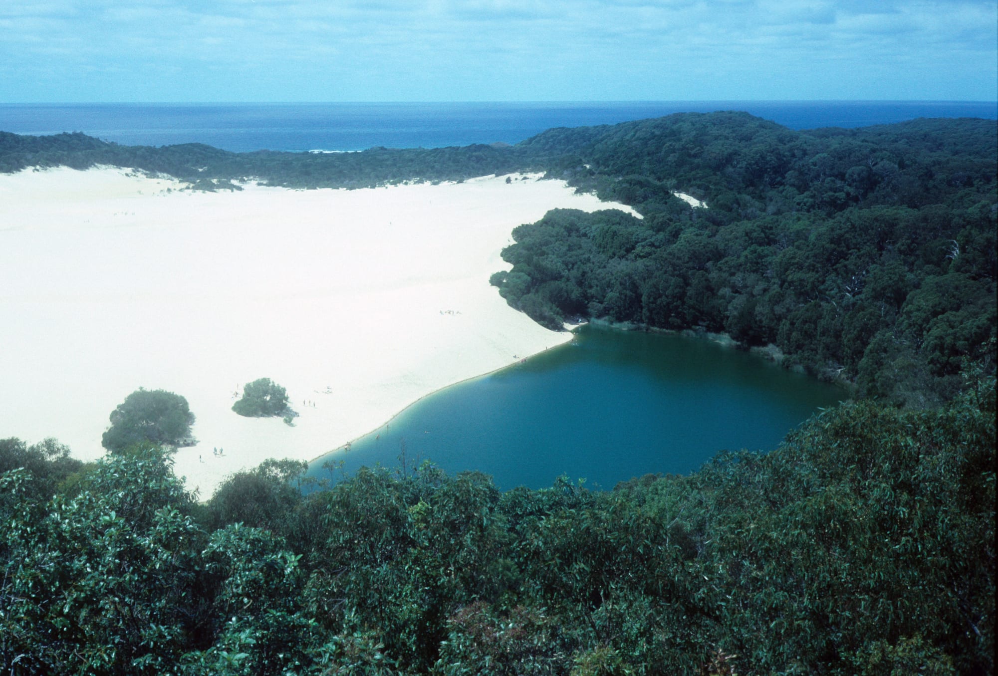
A deep green lake held back by a huge white sand dune, with dense forest around it and the open ocean beyond

Queensland, Australia

K'gari

Lake Wabby and the sand blow slowly advancing into it, on K'gari. (Iraphne R. Childs / Wikimedia Commons · CC BY 4.0)

The world's largest sand island, lying off the southern Queensland coast in the country of the Butchulla people. About 120 kilometres long and built entirely of sand, it carries tall rainforest, more than a hundred freshwater lakes and a surf beach used as a road. Sand mining ended in the 1970s and logging in 1991; it became a World Heritage Site in 1992 and was officially renamed K'gari in 2023.

Neighbourhoods

  • Kingfisher Bay
    • First-time visitors
    • Arriving without a vehicle
    • Sunsets

    The resort village on the sheltered western shore, reached by passenger ferry as well as vehicle barge. It has the island's largest cluster of rooms, bars and restaurants, a long jetty over the Great Sandy Strait, ranger talks and guided trips, and it faces west for the evening light.

    Open in Maps
  • Eurong
    • First-time visitors
    • Close to the lakes
    • Beach driving

    The main township on the ocean side, at the point where the inland track from the western barge landing meets Seventy-Five Mile Beach. A general store, a bakery, a beach resort and a fuel stop make it the practical centre of the island's east coast.

    Open in Maps
  • Happy Valley
    • Quiet and residential
    • Families
    • Fishing

    A small settlement of houses and holiday cabins set back from the ocean beach about halfway up the island, with a store and a handful of places to stay. It sits within easy driving distance of the best-known stretch of the beach and the creeks that cross it.

    Open in Maps
  • Orchid Beach
    • Remote stays
    • Fishing
    • Quiet

    The northernmost settlement, beyond the rocky headlands that break the long beach, with a general store and little else. It is the base for the remote northern end of the island and for surf fishing away from the crowds.

    Open in Maps
  • The camping zones
    • Camping
    • Budget travellers
    • Stargazing

    Most visitors sleep in tents or roof-top tents rather than buildings, either in fenced campgrounds with water and toilets or in designated zones on the ocean beach itself. All of them need a permit booked in advance, and food has to be locked away from dingoes.

    Open in Maps

Things to do

The lakes

  • Lake McKenzieattraction

    Known to the Butchulla as Boorangoora, a perched lake of rainwater held in the dunes, ringed by white silica sand and famous for the clarity of its water.

    Open in Maps
  • Lake Wabbyattraction

    The island's deepest lake, pinned against a vast moving sand blow that is gradually filling it, reached on foot across the open sand.

    Open in Maps
  • Lake Boomanjinattraction

    The largest perched lake in the world, in the south of the island, its water stained a reddish brown by tannins from the tea trees around it.

    Open in Maps

The ocean beach

  • Wreck of the Mahenolandmark

    The rusting hull of a trans-Tasman liner that was blown ashore in 1935 while being towed to Japan for scrap, now half buried in the sand of the beach.

    Open in Maps
  • Indian Headviewpoint

    A rocky headland named by James Cook in 1770, climbed for a view down the beach and over clear water where sharks, manta rays and passing whales are often seen.

    Open in Maps

Forest, dunes and the far north

  • Great Sandy National Parkpark

    The protected area covering almost the whole island, with boardwalks through tall satinay and kauri pine forest, the campgrounds and permits that govern any visit, and the ocean beach that doubles as the main road, with Eli Creek and the coloured Pinnacles cliffs along it.

    Open in Maps
  • Sandy Cape Lightlandmark

    A cast-iron lighthouse of 1870 at the island's northern tip, a long and tide-dependent drive beyond the last settlement.

    Open in Maps

Short trips from the island

  • Hervey Bayattraction

    The mainland town facing the island across the strait, the departure point for most barges and tours and one of Australia's main whale-watching harbours.

    Open in Maps
  • Rainbow Beachattraction

    A small surf town at the southern crossing, backed by coloured sand cliffs, where the short barge from Inskip Point reaches the island's southern tip.

    Open in Maps

Eat and drink

Long-standing places and food districts in K'gari. Hours, ratings and directions come from your maps app, always current.

Eating on the island

  • Eurongneighborhood

    The east coast's practical centre, with a general store for supplies, a bakery and the dining room and bar of its beach resort — the usual stop for a cooked meal after a day on the sand.

    Open in Maps
  • Kingfisher Bayneighborhood

    The island's widest choice of food and drink, from a bar on the jetty looking across the Great Sandy Strait to sit-down dining that makes a point of native Australian ingredients.

    Open in Maps
  • Happy Valley and Orchid Beachneighborhood

    Two small settlements further north, each with a general store and somewhere simple to eat, and the last place to buy anything before the remote northern end of the island.

    Open in Maps

Stocking up on the mainland

  • Hervey Bay's Esplanadeneighborhood

    The waterfront strip of the mainland town, with supermarkets and seafood outlets used to provision a trip and a run of cafés and restaurants along the beach.

    Open in Maps
  • Rainbow Beachneighborhood

    The last town before the southern barge, with a bakery, cafés and a supermarket on its single main street, and fish and chips eaten looking out at the surf.

    Open in Maps

Experience K'gari

History

K'gari has been Butchulla country for thousands of years, and its name means paradise in the Butchulla language. Shell middens, fish traps and scarred trees survive along the shores, and the island supported a substantial population that moved between the coast, the lakes and the forest with the seasons.

James Cook sailed past in 1770 and named Indian Head and Sandy Cape, and Matthew Flinders landed in 1802. In 1836 survivors of the wreck of the Stirling Castle came ashore, among them Eliza Fraser, whose much-embroidered account of her weeks with the Butchulla made her famous in Britain and attached her husband's name to the island for nearly two centuries. Timber-getters arrived from the 1860s and cut satinay, kauri pine and blackbutt; satinay logs were shipped abroad for harbour and canal works, among them the construction of the Suez Canal. Most Butchulla people were removed to mainland missions by the early twentieth century, and the island was left to loggers, fishers and sand miners.

The long campaign to protect it was led by the Fraser Island Defenders Organisation, which fought the granting of further sand-mining leases from 1971 and won a case in the High Court. Mineral sand mining ended in 1977 and logging in 1991, and UNESCO inscribed the island as a World Heritage Site in 1992. The Butchulla won recognition of native title over the island in 2014, and in 2023 the name Fraser Island was formally replaced by K'gari.

Culture & Customs

Two cultures overlap here. The first is Butchulla. The traditional owners share in managing the island with Queensland's parks service, Welcome to Country ceremonies open events, and three lores summarise the Butchulla code — what is good for the land comes first; if there is plenty, it must be shared; and what does not belong to a person must not be taken. Butchulla names have been returned to the map, Boorangoora for Lake McKenzie among them, and the island's own name replaced Fraser in 2023.

The second is the culture visitors bring. K'gari is an institution in Australian holidaymaking. Families who have driven the beach for three generations, convoys of hired four-wheel drives, backpacker tag-along tours out of Rainbow Beach and the winter tailor run, when surf fishers line the ocean beach for the migrating fish, all meet on the same strip of sand. Camping is the traditional way to stay, in fenced campgrounds or in beach zones, and much of the social life of a trip happens around a camp table.

Manners follow the conditions. Drivers give way on single-lane tracks, raise a hand in passing and stop for anyone bogged in soft sand. Approaching or feeding a dingo is treated as a serious offence rather than a bad habit, and rangers enforce it. Visitors are expected to leave with everything they brought, including their rubbish.

Daily Life

Only a couple of hundred people live on K'gari permanently: the 2021 census counted 152 residents. They are spread between Eurong, Happy Valley, Orchid Beach, Kingfisher Bay and a scatter of smaller settlements, and almost all of them work in tourism — in the resorts, general stores and tour businesses — or for the parks service as rangers and traditional owner ranger teams.

Daily life is set by the barge and the tide. Food, fuel, building materials and post cross from River Heads and Inskip Point, the beach road opens and closes with the water, and a badly timed run means waiting. Power comes from generators and solar panels, water from bores in the sand, and waste leaves the island the way it arrived. There is no hospital and no sealed road, so a serious illness means a flight or a boat to Hervey Bay, and schooling beyond the youngest years generally means the mainland.

Visitor numbers dominate both the economy and local argument: how many vehicles the beach can carry, how camping and permits are managed, and how dingoes and people can be kept apart. Recovery from the fire that burned across a large part of the island in late 2020, and the state of the tracks after heavy summer rain, are the other recurring concerns.

Food

Nothing is farmed on K'gari, and almost everything eaten there has crossed the water. The island's own food is what the sea and the sand give up. Tailor, whiting, bream, dart and flathead are caught from the ocean beach, mud crabs and sand crabs come from the mangroves of the Great Sandy Strait on the sheltered western side, and worms and pippies are dug out of the wet sand for bait. Tailor, grilled or salted, is the fish most closely associated with the island, and the winter run of them is a fixture of the Queensland fishing year.

Butchulla food came from the same coast — fish driven into the shallows, shellfish, turtle and dugong, and fruits and roots from the forest and the low wallum heath — and the shell middens along the shore mark where it was eaten.

Eating out means the settlements. Eurong has a general store, a bakery and a resort dining room; Kingfisher Bay has the widest choice, from a bar on the jetty to a restaurant built around native Australian ingredients; Happy Valley and Orchid Beach have small stores and simple meals. Most visitors self-cater and shop on the mainland at Hervey Bay, Maryborough or Rainbow Beach before crossing. Regional flavours come from the wider Fraser Coast — seafood from the bay, rum and ginger beer from Bundaberg up the coast, and summer mangoes and macadamias.

Planning tools

Budget

K'gari is expensive to reach and not cheap to stay on. Vehicle barges, parks vehicle access and camping permits, four-wheel-drive hire and fuel bought on the island account for most of the cost, and food and drink are dearer than on the mainland because everything arrives by boat. Guided day trips from Hervey Bay or Rainbow Beach, and multi-day tag-along tours, are often the cheapest way to see it.

Daily Budget Midrange
USD 200–360 (resort room or holiday cabin, restaurant meals, a guided trip, four-wheel-drive hire and fuel)
Daily Budget Shoestring
USD 90–160 (camping or a tag-along tour, self-catering, a share of four-wheel-drive hire and barge fares)

Book barges, campsites and permits well before school holidays, and carry more drinking water, food and fuel than a mainland trip would need.

Best Time to Visit

August to October is the most settled time, with mild dry days, wildflowers on the heath and whales in the strait. May to October is dry and pleasant overall, and the winter months bring the tailor fishing season. Summer, from December to February, is hot and humid, with heavy rain that can wash out tracks, and the Australian school holidays fill the campgrounds.

Suggested Number of Days

Two or three days suit a first visit and match the length of most organised trips. Four to six allow the remote north, the walking tracks and time on the mainland coast either side. Tides, soft sand and low speed limits mean distances take far longer here than a map suggests.

First Visit
2–3 days
With Surroundings
4–6 days

Transportation

There are no sealed roads. Everything is reached by four-wheel drive, either on narrow inland sand tracks or along the hard sand of the ocean beach, where highway rules apply and vehicles give way to oncoming aircraft. Beach driving is timed around low tide, and creek crossings and washouts can close sections at short notice. Vehicles need a parks access permit, and two-wheel-drive cars, caravans and trailers are not suitable. Visitors without a vehicle rely on guided day tours, tag-along tours and resort buses.

Let tyre pressures down for soft sand, carry a tide chart, and treat the beach as a road — light aircraft also land on it.

Airport & Station Connections

Access is by barge. Vehicle barges cross from River Heads, south of Hervey Bay, to the western landings at Wanggoolba Creek and Kingfisher Bay in under an hour, and from Inskip Point near Rainbow Beach to Hook Point at the southern tip in about ten minutes. A passenger ferry runs to Kingfisher Bay. Hervey Bay has the nearest airport, with flights from Brisbane, Sydney and Melbourne, and Brisbane is roughly 300 kilometres away by road. Day tours and scenic flights also leave from Hervey Bay and Rainbow Beach.

Walkability

Nothing on the island is walkable from anywhere else, as the settlements are tens of kilometres apart and linked only by sand. Within them, and around the lakes, walking is easy on boardwalks and short forest circuits from the car parks, and the beach can be walked for hours. Longer tracks cross the island, including a signposted long-distance route of about 90 kilometres in several sections. Soft sand, heat and the need to watch for vehicles on the beach make progress slower than distances suggest.

Safety

The risks here are natural rather than criminal. Dingoes live wild on the island and have injured visitors, including a fatal attack on a child in 2001; feeding them is an offence. The ocean beach is not safe for swimming because of strong currents and sharks, so people swim in the lakes and sheltered pools instead. Beach and track driving causes serious accidents every year, usually rollovers at speed or in washouts. Mobile coverage is patchy and medical help is a long way off.

Keep well away from dingoes and never feed them, keep children close and within arm's reach, swim in the lakes rather than the sea, and drive slowly and with the tides. Check current official travel advice before travelling.

Climate

Subtropical and strongly maritime, with the surf and a south-easterly wind moderating the heat on the ocean side. Summer in the southern hemisphere runs from December to February and brings most of the year's rain in afternoon storms; winter is mild and largely dry. Cyclones and east-coast lows can bring heavy rain and big surf, mainly between December and April.

Summer
hot and humid, generally about 22–30°C, with thunderstorms and downpours from December to February
Winter
mild and mostly dry, roughly 10–22°C, with cool nights and fresh mornings inland

Local Customs

This is Butchulla country, and visitors are asked to treat it as such. Cultural sites, middens and burial places are not to be disturbed, and some areas are closed to the public. National park rules shape everyday conduct more than local etiquette does — take all rubbish away, keep food and scraps locked up, camp only where permitted, keep to the tracks and light fires only in the places set aside for them. Drivers give way and raise a hand on single-lane tracks. Dress is casual everywhere.

Tipping is not expected in Australia. Alcohol restrictions apply in some camping areas at certain times of year, food must be stored where dingoes cannot reach it, and it is polite to ask before photographing residents or cultural sites.

Common Payment Methods

The currency is the Australian dollar. Cards and contactless payment are taken at the resorts, stores and fuel points, but mobile coverage is patchy and terminals sometimes fail, so some cash is worth carrying. There are few places to withdraw money on the island; the reliable banks and machines are in Hervey Bay, Maryborough and Rainbow Beach. Parks and camping permits are bought online before arriving.