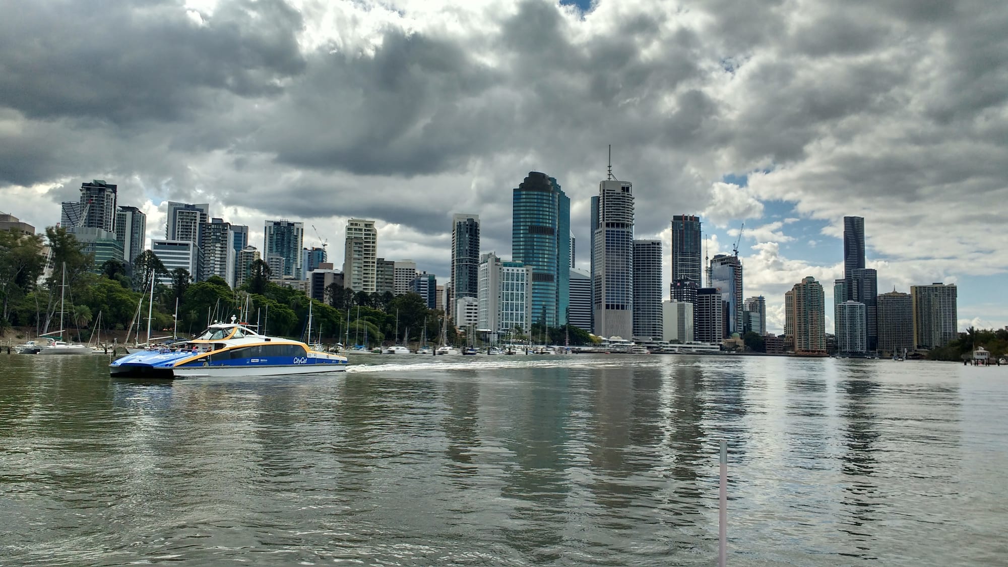
Brisbane's high-rise skyline across the wide brown river, with a blue and yellow CityCat ferry passing moored yachts

Queensland, Australia

Brisbane

The Brisbane skyline across the river from Kangaroo Point, with a CityCat ferry on the water. (Deepeshmd / Wikimedia Commons · CC BY-SA 4.0)

Brisbane is Queensland's capital, a subtropical city of about 2.8 million people set in the bends of the Brisbane River some twenty kilometres from Moreton Bay. Founded as a convict settlement in the 1820s and long dismissed by southern Australians as a country town, it is now the country's third-largest city and will host the 2032 Olympic Games.

Neighbourhoods

  • The city centre
    • First-time visitors
    • Shopping
    • Close to public transport

    A compact grid on a bend of the river, with the pedestrianised Queen Street Mall at its heart, City Hall and the sandstone government buildings around it, and the City Botanic Gardens at the point. Most hotels, the main train and bus interchanges and the ferry terminals are here.

    Open in Maps
  • South Bank
    • Museums
    • Families
    • Riverside

    The old Expo site directly across the river, now a strip of parkland with a swimming lagoon, a bougainvillea walkway and the state art gallery, museum, library and performing arts centre lined up along it. Restaurants and cafés face the water, and footbridges lead into the centre.

    Open in Maps
  • Fortitude Valley
    • Nightlife
    • Live music
    • Best for food

    A short walk north-east of the centre and the city's night district for a century, with live-music rooms, bars and clubs, a Chinatown mall, record shops and street art. Much of it is being rebuilt with apartment towers, and the streets are busy late on weekends.

    Open in Maps
  • West End
    • Best for food
    • Markets
    • Local life

    A peninsula suburb south of the river with a long Greek and, later, Vietnamese and Middle Eastern presence. Boundary Street is lined with cafés, bookshops, bars and cheap restaurants, a large weekly market fills a riverside park, and the housing is a mix of workers' cottages and new flats.

    Open in Maps
  • New Farm and Teneriffe
    • Quiet and residential
    • Cafés
    • Riverside walks

    Leafy inner suburbs in a loop of the river north-east of the centre, reached by ferry. Teneriffe's brick wool stores have become apartments, New Farm has a large riverside park and an arts venue in a former power station, and Merthyr Village and Brunswick Street hold the cafés and delicatessens.

    Open in Maps
  • Paddington and Petrie Terrace
    • Historic homes
    • Shopping
    • Sport

    Ridges of timber Queenslander houses on stumps just west of the centre, with antique shops, cafés and small bars along Given Terrace and Latrobe Terrace. The main rugby league and football stadium sits at the bottom of the hill, so the streets fill on match nights.

    Open in Maps
  • Kangaroo Point and Woolloongabba
    • Views
    • Sport
    • Close to the centre

    A peninsula opposite the centre, edged by volcanic cliffs used for climbing and abseiling, with a riverside path and the classic view of the skyline. Behind it Woolloongabba has the city's cricket and Australian football ground, antique dealers and a growing run of restaurants.

    Open in Maps

Things to do

Famous landmarks

  • Story Bridgelandmark

    The steel cantilever bridge of 1940 that carries traffic, cyclists and walkers across the river, designed by the engineer who planned the Sydney Harbour Bridge and lit at night.

    Open in Maps
  • Brisbane City Halllandmark

    The 1930 sandstone civic building on King George Square, with a clock tower that can be climbed by lift for a view over the centre and a domed concert hall inside.

    Open in Maps
  • Customs Houselandmark

    A copper-domed classical building of 1889 on the riverbank, built to collect duty on cargo and now run by the University of Queensland.

    Open in Maps
  • Parliament Houselandmark

    Queensland's French Renaissance style parliament of 1868 at Gardens Point, home to the only single-chamber state parliament in Australia and open for guided tours.

    Open in Maps
  • Queen Street Mallattraction

    The pedestrianised heart of the centre, several blocks of department stores, arcades and street performers, including the Brisbane Arcade of 1924, the oldest in the city.

    Open in Maps

Museums and galleries

  • Queensland Art Gallerymuseum

    The state collection of Australian, Indigenous Australian and Asian art, in a 1982 building by Robin Gibson, arranged around a watermall, on the South Bank cultural precinct.

    Open in Maps
  • Gallery of Modern Artmuseum

    Australia's largest gallery of modern and contemporary art, opened next door in 2006, known for the Asia Pacific Triennial it runs with the art gallery and for its children's art centre.

    Open in Maps
  • Queensland Museummuseum

    The state museum in the cultural centre at South Brisbane, with dinosaur fossils, Queensland wildlife in its Wild State gallery and Mephisto, the only surviving German A7V tank of the First World War.

    Open in Maps
  • Museum of Brisbanemuseum

    The city's own museum, on the third floor of City Hall, with changing exhibitions on Brisbane's history, art and people.

    Open in Maps
  • State Library of Queenslandmuseum

    A free public building on South Bank with exhibition galleries, reading rooms and the state's historical photograph and manuscript collections.

    Open in Maps

Parks, the river and wildlife

  • South Bank Parklandspark

    Riverside parkland built on the 1988 World Expo site, with a man-made swimming lagoon and beach, a curving bougainvillea arbour, a Nepalese pagoda and an observation wheel.

    Open in Maps
  • City Botanic Gardenspark

    The city's first gardens, laid out in the 1850s on the river point below Parliament House, with avenues of bunya pines, figs and paths along the river.

    Open in Maps
  • Roma Street Parklandpark

    A subtropical garden on former railway land beside Roma Street station, said to be the largest in any city centre, with a lake, a rainforest walk and banks of flowering plants.

    Open in Maps
  • Mount Coot-thaviewpoint

    A forested hill about seven kilometres west with a lookout over the whole city to Moreton Bay, a large botanic garden at its foot and a planetarium beside it.

    Open in Maps
  • Kangaroo Point Cliffsviewpoint

    Low cliffs of volcanic rock quarried in the convict era, now used for climbing and abseiling, with a parkland path along the top facing the skyline.

    Open in Maps
  • Lone Pine Koala Sanctuaryattraction

    A wildlife sanctuary founded in 1927 on the river upstream of the city, the oldest of its kind, with a large koala population as well as kangaroos, wombats and platypus.

    Open in Maps

Sport, music and nights out

  • Brisbane Cricket Groundattraction

    Known universally as the Gabba, the ground at Woolloongabba where cricket Tests are played early in the summer and the Brisbane Lions play Australian football.

    Open in Maps
  • Suncorp Stadiumattraction

    The rectangular stadium at Milton, still called Lang Park by locals, used for rugby league, rugby union and football, and famous for its noise.

    Open in Maps
  • Queensland Performing Arts Centreattraction

    Four theatres on South Bank, home to the state opera, ballet, theatre company and symphony orchestra, and the main stage for touring productions.

    Open in Maps
  • Howard Smith Wharvesattraction

    A strip of old cargo wharves under the Story Bridge, redeveloped in 2018 as a riverside precinct of restaurants, bars and an outdoor lawn for concerts.

    Open in Maps
  • Brisbane Powerhouseattraction

    A brick tram power station in New Farm Park converted into a theatre and live arts venue, with its industrial shell and graffiti left in place.

    Open in Maps

Short trips from the city

  • North Stradbroke Islandattraction

    A large sand island in Moreton Bay, called Minjerribah by the Quandamooka people, with surf beaches, a headland walk, freshwater lakes and whales offshore in winter.

    Open in Maps
  • Moreton Islandattraction

    Almost entirely sand and national park, reached by ferry, with the wrecks of the Tangalooma ships, giant dunes for sandboarding and wild dolphins at the resort.

    Open in Maps
  • Glass House Mountainsattraction

    A group of volcanic plugs rising abruptly from farmland an hour north, named by James Cook in 1770 and important to the Jinibara and Gubbi Gubbi peoples.

    Open in Maps
  • Tamborine Mountainattraction

    A rainforest plateau in the Gold Coast hinterland with waterfall walks, a glow-worm cave, wineries and galleries, about an hour's drive south.

    Open in Maps
  • Australia Zooattraction

    The large wildlife park at Beerwah founded by the Irwin family, known for its crocodile shows and its wildlife hospital, about an hour north of the city.

    Open in Maps

Seasonal events

  • Royal Queensland ShowAugust

    Known as the Ekka, the state agricultural show at Bowen Hills, held over ten days, with animal parades, woodchopping, showbags and nightly fireworks.

  • Brisbane FestivalSeptember

    Three weeks of theatre, music, circus and outdoor performance across the city, the largest arts event of the Brisbane year.

  • RiverfireSeptember

    One of Queensland's largest fireworks displays, staged over the river as part of the Brisbane Festival and watched from the banks by hundreds of thousands of people.

  • Buddha Birth Day FestivalMay

    A festival on South Bank with vegetarian food stalls, lantern floating, dragon dancing and ceremonies, the largest event of its kind in Australia, drawing more than 200,000 people a year.

  • PaniyiriMay

    A Greek festival held in Musgrave Park at South Brisbane since 1976, the longest-running Greek festival in Australia, with food, dancing and music.

Eat and drink

Long-standing places and food districts in Brisbane. Hours, ratings and directions come from your maps app, always current.

Food districts

  • West End and Boundary Streetneighborhood

    Greek delicatessens and cake shops beside Vietnamese, Lebanese, Indian and modern Australian kitchens, with a strong café and small-bar scene and a big share of the city's vegetarian cooking.

    Open in Maps
  • Fortitude Valley and Chinatownneighborhood

    The Chinatown mall and the streets around it hold Cantonese, Sichuan, Korean, Japanese and Vietnamese restaurants, dumpling and noodle houses, bakeries and late-night bars.

    Open in Maps
  • Howard Smith Wharvesneighborhood

    Restaurants and bars in converted wharf sheds under the Story Bridge, a popular place in the city for a drink by the water.

    Open in Maps
  • Bulimba and Oxford Streetneighborhood

    A relaxed suburban high street across the river, reached by ferry, with cafés, bakeries, pubs and neighbourhood restaurants used mostly by locals.

    Open in Maps

Markets

  • Davies Park Marketmarket

    A weekly market in a riverside park at West End, with farm produce, tropical fruit, bread, coffee and cooked food from many cuisines.

    Open in Maps
  • Eat Street Northshoremarket

    A weekend night food market on a repurposed wharf at Northshore Hamilton, downstream of the centre, with stalls from local restaurants and food trucks.

    Open in Maps

Experience Brisbane

History

The river flats and ridges here are the country of the Turrbal and Jagera peoples, who knew the site by names recorded as Meanjin, and who used the bend in the river as a crossing and a meeting place. European settlement began as punishment: in 1824 a penal station for repeat offenders was placed at Redcliffe on the bay, and moved the following year to the river, where fresh water and a defensible bend suited the authorities. It was named after Sir Thomas Brisbane, then governor of New South Wales. The regime under Captain Patrick Logan in the late 1820s was notoriously brutal, and free settlers were kept away until 1842.

Once opened, the town grew as a river port for wool, timber and sugar, and when Queensland separated from New South Wales in 1859 Brisbane became the capital of the new colony. Floods in 1893 and 1974 shaped where people built. In 1925 the local authorities of the area were merged into a single City of Brisbane, then Australia's largest municipal authority.

In 1942 General Douglas MacArthur made the city his headquarters for the South West Pacific, thousands of American servicemen passed through, and tension with Australian troops broke into two nights of rioting. The 1982 Commonwealth Games and World Expo 88 rebuilt the riverfront and gave the city South Bank; the Fitzgerald Inquiry of the late 1980s ended a long era of police and political corruption. The city has since grown quickly, flooded again in 2011 and 2022, and won the 2032 Olympic Games.

Culture & Customs

For most of the twentieth century Brisbane was described, by southerners and by its own writers, as a large country town — humid, conservative and half asleep. That version of the city has largely gone, but the habits it left are visible: life is lived outdoors, on verandahs, at the river and in parks, and the timber Queenslander house raised on stumps, with lattice and wide verandahs, is the local emblem.

Music is the city's strongest cultural export. The Saints, formed here in the early 1970s, were among the first punk bands anywhere; the Go-Betweens, whose name is on one of the river bridges, and later Powderfinger came out of the same inner-suburban circuit, and Fortitude Valley still has the live-music rooms that produced them. The cultural precinct on South Bank draws very large audiences to its galleries, and the Asia Pacific Triennial has shaped how Australians see art from the region.

Sport organises the year: rugby league above all, with the Broncos at Suncorp Stadium and the State of Origin series against New South Wales, along with cricket and Australian football at the Gabba and the approach of the 2032 Olympics. The city is markedly multicultural, with large Chinese, Indian, Vietnamese, Korean and Pacific Islander communities, and festivals to match, from the Greek Paniyiri at Musgrave Park to the Buddha Birth Day gathering on South Bank. Manners are casual and direct, and Queensland's refusal of daylight saving is still argued about.

Daily Life

About 1.3 million people live within the City of Brisbane and roughly 2.8 million in the wider metropolitan area, which now runs almost continuously from the Sunshine Coast to the Gold Coast. Growth is fast, much of it migration from the southern states, and it is the central fact of daily life: house prices and rents have risen steeply, new apartment towers fill the inner suburbs, and motorways and tunnels have been pushed through the ridges.

The economy rests on state government, health and education, construction, the head offices of mining and energy companies, the Port of Brisbane on the river mouth and a busy airport. Older industrial land along the water has been turned over to flats and restaurants. The inner ring is still mostly timber houses on stumps under mango trees and poincianas; further out are brick and tile estates and the satellite cities of Ipswich, Logan and Moreton Bay.

The rhythm of the day is set by the heat. People run, swim and walk the river paths early, the middle of a summer day is spent indoors or in water, and evenings move outside. Weekends mean sport, the coast or the bay. The recurring public arguments are about housing costs, flood risk and where to build, public transport for a spread-out city, and the cost and value of the coming Olympics.

Food

Brisbane eats outdoors and eats Asian. The city's seafood comes from Moreton Bay and the reef: Moreton Bay bugs, a flat slipper lobster named after the bay, mud crab from the mangrove creeks, spanner crab, prawns, barramundi and coral trout. Tropical produce arrives from the state's north and from the farms immediately inland, so mangoes, lychees, custard apples, macadamias and avocados turn up in everything through the summer.

The food map follows the city's migrations. West End keeps Greek delicatessens and cake shops alongside Vietnamese and Lebanese kitchens; the Chinatown mall in Fortitude Valley covers most of China's regional cooking as well as Korean and Japanese; and Sunnybank, in the southern suburbs, has become the centre of the city's Chinese and Taiwanese food, with whole shopping centres given over to it. Weekend markets — at Davies Park in West End, on South Bank, and on the wharf at Northshore Hamilton — are where much of the city eats.

Coffee is taken seriously, as everywhere in Australia. The brewery at Milton has brewed since 1878 and makes XXXX, the state's standard lager, craft breweries have multiplied along the river and in the Valley, and wine comes up from the Granite Belt on the New South Wales border, high enough for cool nights.

Planning tools

Budget

Brisbane is cheaper than Sydney and a little cheaper than Melbourne, though accommodation has risen sharply with the city's growth. Hotels are concentrated in the centre, South Bank and Fortitude Valley, and prices jump for big sporting fixtures, the Ekka and the September festival season. Museums and galleries in the cultural precinct are largely free.

Daily Budget Midrange
USD 170–300 (a mid-range hotel, restaurant meals, ferries and trains, a wildlife sanctuary or a day trip)
Daily Budget Shoestring
USD 70–110 (a hostel dorm, self-catering and market food, a public transport card, free galleries and the South Bank lagoon)

Buy a Go Card for public transport rather than paying single fares, and note that the state galleries, museum and library, South Bank and the river walks cost nothing.

Best Time to Visit

April to October is the comfortable half of the year: warm, dry and sunny with cool nights in June and July. Spring brings jacaranda and poinciana blossom through the suburbs. From November to March it is hot and humid with violent afternoon storms, but the city is quieter and the river and lagoon make more sense in the heat.

Suggested Number of Days

Two or three days cover the centre, the cultural precinct and the river. Five to seven allow the bay islands, the hinterland and the coasts on either side of the city. More time is needed in summer, when heat and storms slow the pace of everything.

First Visit
2–3 days
With Surroundings
5–7 days

Transportation

One integrated network of trains, buses, busways and CityCat ferries covers the city, paid for with a Go Card or a bank card. Trains run from Central and Roma Street stations to the suburbs and the airport, the CityCats run fast up and down the river and are the pleasantest way to move between riverside suburbs, and the smaller hopper ferries cross between the centre, Kangaroo Point and South Bank. Bike and scooter hire schemes cover the inner city.

The river bends so sharply that suburbs which look close on a map can be far apart by road, and a ferry is often quicker than a bus or a taxi.

Airport & Station Connections

Brisbane Airport, about thirteen kilometres north-east of the centre, is one of Australia's busiest and has direct flights across Asia, the Pacific and the Middle East. The Airtrain runs from both terminals into the centre in around twenty minutes, and taxis take a little longer. Long-distance trains run north to Cairns and south to Sydney from Roma Street, coaches use the same station, and the Gold Coast is about an hour away by road.

Walkability

The centre is small and flat enough to cross on foot in twenty minutes, and the riverside walkways link it to South Bank, Kangaroo Point, New Farm and the Story Bridge in a more or less continuous path. Beyond that the city is hilly and spread out, with steep streets in the inner suburbs. Heat and humidity, not distance, are the limit from November to March.

Safety

Brisbane is a safe city with low levels of violent crime. The usual caution applies late at night around the bars of Fortitude Valley and the centre, where alcohol-related trouble is most common. The real local hazards are environmental: summer heat, sudden severe thunderstorms with hail and flash flooding, and river flooding, which reached the inner suburbs in 1974, 2011 and 2022; ex-tropical cyclone Alfred brought destructive winds and flooding rain to the region in March 2025. Saltwater crocodiles do not live this far south.

Drink water and stay out of the midday sun in summer, take storm and flood warnings seriously, and swim between the flags at bay and coastal beaches. Check current official travel advice before travelling.

Climate

Humid subtropical, with hot wet summers and mild dry winters. Most of the rain falls between November and March, often in short violent storms, and the city is warm enough for outdoor living all year. Frost is unknown in the inner suburbs.

Summer
hot and humid, generally about 21–30°C, with afternoon thunderstorms and occasional heavy rain — summer in the southern hemisphere runs from December to February
Winter
mild and dry, generally about 10–22°C, sunny by day with cool nights and very little rain

Local Customs

Dress is informal, and in summer shorts and sandals are normal almost everywhere. Tipping is not customary in Australia, and prices shown include tax and service. Queensland does not use daylight saving, so in summer the city runs an hour behind Sydney and it gets dark early. Queues are respected, people talk to strangers readily, and the Turrbal and Jagera peoples are acknowledged as the traditional owners of the city at public events.

Carry identification if young (the drinking age is 18), do not drink alcohol in public parks unless signs allow it, and wear sunscreen and a hat, because the subtropical sun burns quickly even in winter.

Common Payment Methods

The currency is the Australian dollar. Cards and phones are used for almost everything, including buses, ferries and market stalls, and many venues no longer take cash at all. ATMs are widespread in the centre and suburban shopping streets. Small card surcharges are common and must be displayed.