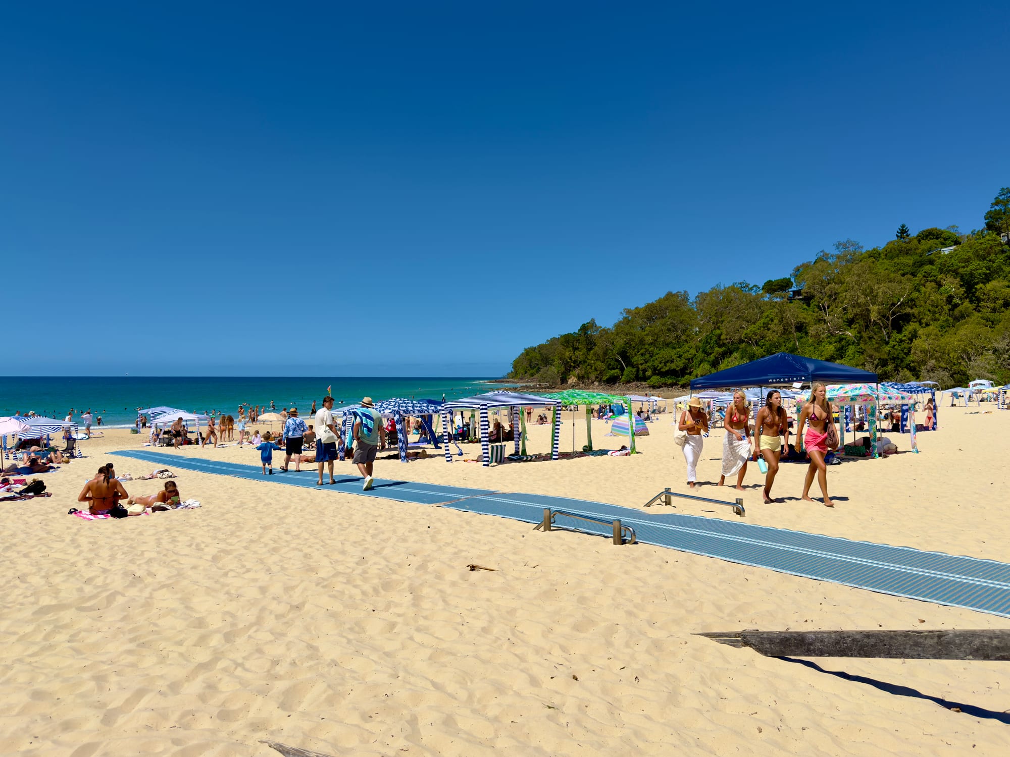
A wide sandy beach with striped beach cabanas and bathers, backed by the forested headland of a national park

Queensland, Australia

Noosa Heads

Main Beach at Noosa Heads, with the forested headland of Noosa National Park beyond. (Chris Olszewski / Wikimedia Commons · CC BY-SA 4.0)

Noosa Heads is a resort town at the northern end of Queensland's Sunshine Coast, where a national park headland shelters a north-facing beach and the Noosa River winds behind the dunes. Strict limits on building height have kept it low-rise and green, and it is known for longboard surfing, walking tracks and the restaurants of Hastings Street.

Neighbourhoods

  • Hastings Street and Main Beach
    • First-time visitors
    • Beaches
    • Best for food

    One low street of resorts, boutiques and restaurants running behind the dunes, with the sheltered north-facing beach on one side and the river mouth at its end. Everything is within a few minutes on foot, including the start of the national park walking track, and it is the most expensive place on the coast to stay.

    Open in Maps
  • Noosa Junction
    • Better value
    • Local life
    • Close to the shops

    The everyday commercial centre on the hill above Hastings Street, a ten-minute walk or a short bus ride away. It has the cinema, the supermarkets, cheaper places to eat and drink and plainer accommodation, and the road over the ridge to Sunshine Beach starts here.

    Open in Maps
  • Sunshine Beach
    • Surfing
    • Quiet and residential
    • Ocean views

    On the far side of the headland, facing straight out to sea, so the surf is bigger and the beach quieter. A small village of cafés, a pub and a surf club sits above the sand, with houses on the slope behind and a walking track over the hill to the national park.

    Open in Maps
  • Noosaville
    • Families
    • Riverside
    • Self-catering

    Spread along the Noosa River a few kilometres west, with lawns and jetties on Gympie Terrace, calm water for children and paddleboards, and a long run of restaurants and cafés facing the water. Holiday units here cost noticeably less than at the beach.

    Open in Maps
  • Tewantin
    • Quiet and residential
    • Better value
    • River trips

    The district's original river port, upriver where the boats once loaded timber. It is a working town rather than a resort, with a pub, shops and boat hire, and the ferry across to the sand tracks of the North Shore leaves from just beyond it.

    Open in Maps

Things to do

Beaches and the headland

  • Noosa National Parkpark

    The headland park beside the town, with a coastal track past rocky points and small bays to Hell's Gate, koalas in the eucalypts and lookouts over the water from the clifftops.

    Open in Maps
  • Main Beachbeach

    A north-facing beach sheltered by the headland, which makes it unusually calm, patrolled, and the place most people learn to surf.

    Open in Maps
  • Sunshine Beachbeach

    A long east-facing surf beach on the other side of the headland, with heavier waves, a patrolled section in front of the village and far fewer people than Main Beach.

    Open in Maps

The river and the lakes

  • Noosa Riverattraction

    A slow river of sandbars, lakes and tea-coloured channels running behind the coast, used for paddling, sailing and fishing and served by a small ferry between the villages.

    Open in Maps
  • Great Sandy National Parkpark

    The Cooloola sand country north of the river, reached by ferry, with the still dark upper reaches of the Noosa River, coloured sands and a long four-wheel-drive beach.

    Open in Maps
  • Tewantinneighborhood

    The upriver town that began as a timber port, with river cruises and boat hire and a ferry crossing to the North Shore dunes.

    Open in Maps

Short trips from the town

  • Eumundineighborhood

    A small hinterland town twenty kilometres inland, known across Queensland for the large craft and produce market held on Memorial Drive twice a week.

    Open in Maps
  • Peregian Beachbeach

    A quiet village and long open beach south of Sunshine Beach, backed by heathland and a national park section good for birdwatching.

    Open in Maps
  • Rainbow Beachbeach

    A small coastal town about two hours north by road, named for the coloured sand cliffs along its beach, with four-wheel-drive access to the Cooloola coast.

    Open in Maps
  • Glass House Mountainsattraction

    Volcanic plugs standing out of the farmland an hour south, named by James Cook in 1770, with lookouts and walking tracks at their feet.

    Open in Maps

Seasonal events

  • Noosa Festival of SurfingMarch

    A week of longboard and traditional surfing contests at the headland points, with the relaxed, retro character that Noosa surfing is known for.

  • Noosa Food and Wine FestivalMay

    Tastings, long lunches and cooking demonstrations across the town and the river, using Sunshine Coast hinterland produce.

  • Noosa Triathlon Multi Sport Festivallate October or early November

    A large triathlon, first held in 1983 and now a five-day festival of races that fills the town, with the swim in Laguna Bay and the run along the river.

  • Humpback whale seasonroughly July to October

    Humpback whales pass close to the headland on their migration, and are regularly seen from the national park lookouts.

Eat and drink

Long-standing places and food districts in Noosa Heads. Hours, ratings and directions come from your maps app, always current.

Food streets

  • Hastings Streetneighborhood

    The beachfront street holds the town's best-known restaurants and cafés, most of them with tables outdoors under the trees, and the cooking leans on seafood and hinterland produce.

    Open in Maps
  • Noosa Junctionneighborhood

    A younger and cheaper alternative uphill, with bakeries, Asian kitchens, small bars, a brewery taproom and the pubs that locals use.

    Open in Maps
  • Gympie Terrace, Noosavilleneighborhood

    Restaurants, fish shops, ice cream and cafés along the river lawns, with pelicans on the jetties and the water a few steps away.

    Open in Maps
  • Sunshine Beach villageneighborhood

    A short row of cafés, a bakery, a wine bar and a surf club dining room above the beach, busy at breakfast and quiet by mid-evening.

    Open in Maps

Markets

  • Eumundi Marketsmarket

    Hundreds of stalls of crafts, clothing, plants, produce and cooked food in the hinterland town, held on Wednesdays and Saturdays and in operation since the 1970s.

    Open in Maps

Experience Noosa Heads

History

The coast, the river and the ranges behind them are the country of the Kabi Kabi people, who fished the river and its lakes and moved inland along the ranges behind. European settlement arrived through timber and gold: when the Gympie field opened in 1867, the Noosa River became a supply route to it, and Tewantin grew as the river port where timber and stores were loaded on to boats.

Noosa Heads itself stayed tiny well into the twentieth century — a scatter of fishing shacks and holiday cottages behind the dunes, reached along sand tracks. What changed it was surfing. In the early 1960s surfers found the long, slow right-hand waves that wrap around the headland points, and the town acquired a reputation that spread through surf films and magazines.

Development pressure followed, and the argument about it has shaped Noosa ever since. Campaigns from the 1960s onwards protected the headland, and the local council adopted planning rules that keep buildings low, so that no towers were ever built and Hastings Street stayed a low-rise street. UNESCO recognised the shire as a biosphere reserve in September 2007, the first in Queensland. In 2008 Noosa was merged into a larger Sunshine Coast council against strong local opposition, and after a referendum it became a separate shire again in 2014 — an unusual reversal in Australian local government, and a good measure of how strongly the place guards its own character.

Culture & Customs

Noosa is a surfing town of a particular kind. The headland's points suit long boards and slow, drawn-out waves rather than the sharp barrels of the Gold Coast, and the town has kept a longboarding culture that its March festival celebrates with older boards, older riders and deliberately relaxed contests. The water is used in every other way as well: ocean swims, paddleboards on the river, kayaks in the lakes, and a triathlon in spring that fills every bed in the shire.

The second strand of local identity is conservation. Residents campaigned for the national park, for the height limits and for the return of their own council, and the biosphere designation is a point of pride. Koalas in the park, water quality in the river and the number of visitors the town can absorb are all live subjects, argued over with unusual persistence.

Socially the town is understated rather than flashy: linen, bare feet, expensive sunglasses and no interest in high-rise glamour. Many residents moved here from southern cities, and the population is older and wealthier than the Queensland average, which shows in the galleries, the food festival and the number of bookshops and cafés. Hinterland villages such as Eumundi keep an alternative, market-garden streak that dates from the 1970s.

Daily Life

Noosa Heads itself has only a few thousand residents, and the Shire of Noosa around it somewhere over fifty thousand, spread between the beach villages, the river towns and the farms inland. The population is markedly older than the national average, and grows every holiday season with visitors who outnumber residents.

Almost all local work is tourism and the services behind it: hotels, restaurants, cleaning and maintenance, retail, construction, health and aged care. That has produced the town's sharpest problem. Housing here is among the most expensive in Queensland, a large part of the housing stock is let to visitors, and the people who staff the restaurants and resorts increasingly commute from Cooroy, Nambour or further south. Short-term letting and its limits are a standing political argument.

The bigger shops, medical services and schools are at Noosa Junction, Noosaville and Tewantin rather than on Hastings Street. Days begin early, with swimmers and walkers on the beach and the headland track before breakfast; summer afternoons are broken by storms; traffic and parking are the main daily irritation in January and at Easter. Floods on the Noosa River, bushfire in a dry spring and erosion of Main Beach after big swells are the recurring practical worries.

Food

The river and the sea supply the basics: prawns and mud crab from the Noosa River and the lakes, spanner crab, whiting and reef fish, sold from fish shops along Gympie Terrace and at Tewantin and cooked with very little done to them. Eating outdoors is the norm, whether that means a restaurant table under the trees on Hastings Street, fish and chips on the river lawns or a surf club dining room above the sand.

The hinterland is the other half of the story. The ranges and valleys inland grow macadamias, avocados, pineapples, custard apples and tropical fruit, ginger is processed at Yandina, and small dairies in the hills behind make cheese and cream. Much of it reaches the coast through the markets: the big craft and produce market at Eumundi on Wednesdays and Saturdays, and smaller produce markets along the coast.

Noosa has a large number of restaurants for a town of its size, and the style is broadly modern Australian with strong Italian, Japanese and South-East Asian threads. Coffee is taken seriously, breakfast is a serious meal, and small breweries and distilleries have opened at Noosaville and in the hinterland. The food festival in May is now one of the larger events of the local year.

Planning tools

Budget

Noosa is one of the more expensive holiday towns in Australia. Hastings Street commands resort prices and rises sharply over Christmas, January and Easter, when many places also set minimum stays. Staying at Noosaville, Noosa Junction or Tewantin and travelling in cuts the cost considerably, and much of what the town is visited for is outdoors and free.

Daily Budget Midrange
USD 200–350 (a holiday apartment or hotel, restaurant meals, a river or beach activity, a hire car)
Daily Budget Shoestring
USD 80–140 (a hostel bed or caravan park site, self-catering and market food, local buses, the beach and the national park)

Book well ahead for the summer school holidays and the triathlon weekend; the national park track, the beaches, the river lawns and the lookouts cost nothing.

Best Time to Visit

April to May and September to November are the best months: warm, dry and not yet crowded, with the water still comfortable. Winter is mild, sunny and quiet, with whales offshore. Summer is hot and humid with afternoon storms, and the Christmas and January school holidays are the busiest and most expensive weeks of the year.

Suggested Number of Days

Two or three days cover the beaches, the headland walk and the river. Four to six allow the hinterland, the sand country north of the river and slower beach days. Longer stays are common here, and many visitors take a week in an apartment rather than a few nights.

First Visit
2–3 days
With Surroundings
4–6 days

Transportation

The town is small and most people walk. Local buses link Noosa Heads, Noosa Junction, Noosaville, Tewantin, Sunshine Beach and the southern beach villages, and a small passenger ferry runs up and down the river between the main stops. A hire car is useful for the hinterland and the coast south, and a four-wheel-drive is needed for the sand tracks north of the river. Bicycles suit the flat riverside roads.

Parking at Hastings Street and the national park entrance fills early in holiday periods, and the free shuttle buses and the river ferry are usually easier than looking for a space.

Airport & Station Connections

Sunshine Coast Airport at Marcoola is about thirty-five kilometres south, roughly forty minutes by road, with flights from the Australian capitals and seasonal services from New Zealand. Brisbane Airport is about two hours away and has far more services. Trains on the North Coast line stop inland at Cooroy and Nambour, with buses on to the coast, and long-distance coaches run up the Bruce Highway.

Walkability

Hastings Street, Main Beach, the river mouth and the start of the national park track form a flat, easily walked strip, and the coastal path continues for kilometres into the park. Noosa Junction and Sunshine Beach sit on ridges, so walking between them and the beach involves a real climb. The riverside footpaths at Noosaville are level and pleasant.

Safety

This is a safe, low-crime town, and the risks are those of the coast. Main Beach is sheltered and patrolled, but Sunshine Beach and the open beaches to the south have strong rips and are patrolled only in sections. Summer brings severe thunderstorms, the national park is bushfire country in a dry spring, and the sun is strong. Saltwater crocodiles do not live this far south.

Swim between the red and yellow flags, ask a lifesaver about the rips before entering the surf on the open beaches, and carry water and a hat on the headland track, which has little shade in places. Check current official travel advice before travelling.

Climate

Subtropical and mild, with warm humid summers, dry sunny winters and most of the rain falling between December and March, often in heavy storms. Sea breezes keep the coast a few degrees cooler than the hinterland, and the water is warm enough to swim in all year for most people.

Summer
hot and humid, generally about 21–29°C, with afternoon thunderstorms and sea temperatures near 26°C — summer in the southern hemisphere runs from December to February
Winter
mild and dry, generally about 10–22°C, sunny by day with cool nights and sea temperatures near 20°C

Local Customs

Dress is casual but a little more considered than on most of the Queensland coast: linen and sandals rather than board shorts on Hastings Street in the evening, though nobody expects a jacket. Tipping is not customary in Australia and prices include tax and service. Queensland does not use daylight saving. Alexandria Bay, in the national park, has long been used by nude bathers, while the town beaches are not.

Keep dogs off the patrolled beaches and out of the national park, do not feed the koalas or the birds, and carry sunscreen and a hat, because the subtropical sun burns quickly even in winter.

Common Payment Methods

The currency is the Australian dollar. Cards and phones are accepted almost everywhere, including at market stalls and on the buses, and some venues are cashless. ATMs are in Noosa Junction, Noosaville and along Hastings Street. Card surcharges are common and must be displayed.