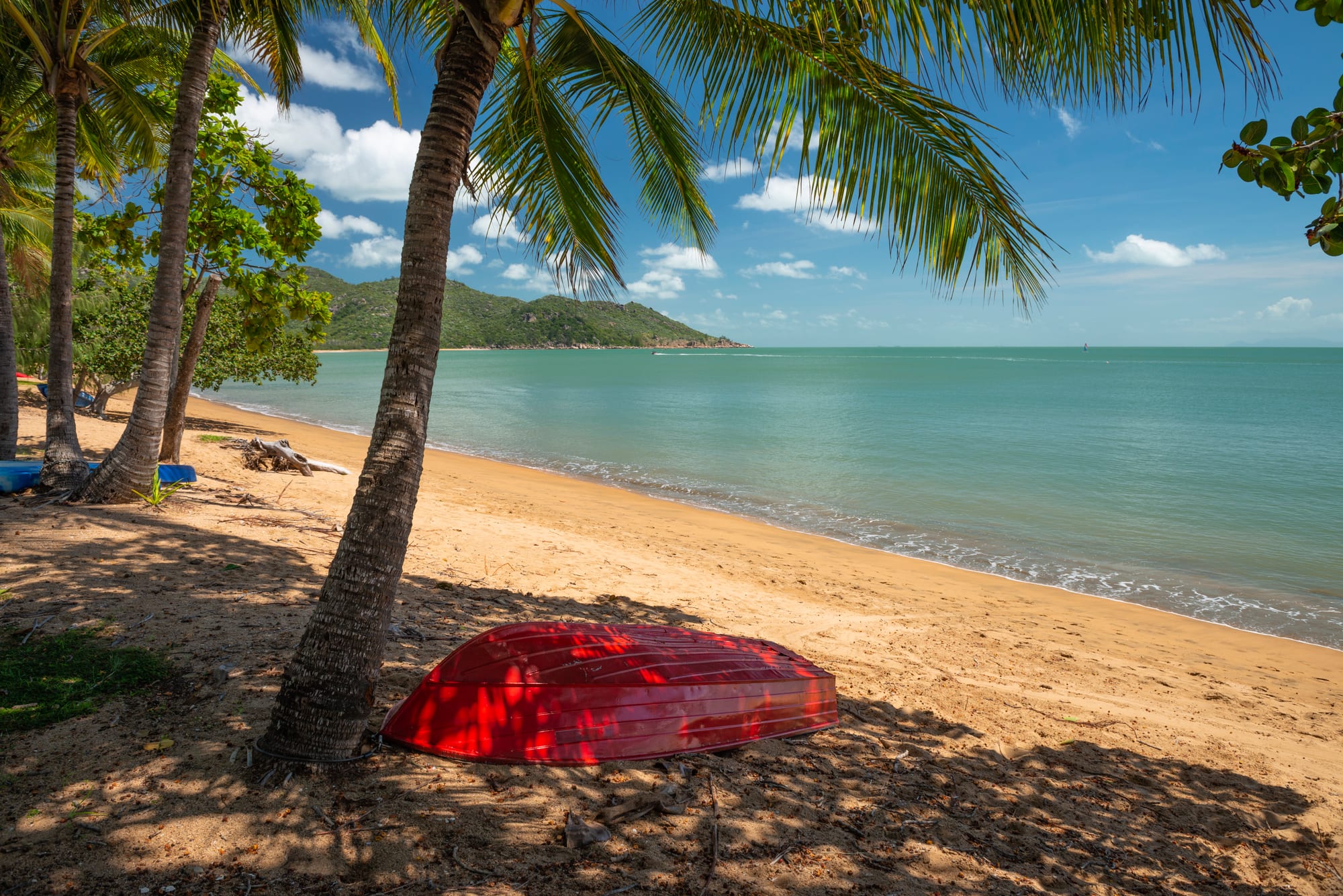
Palms leaning over an empty sand beach with a red upturned dinghy, a green headland and calm turquoise water

Queensland, Australia

Magnetic Island

Horseshoe Bay on the northern shore of Magnetic Island. (Joshua Tagicakibau / Wikimedia Commons · CC BY-SA 4.0)

A granite island in Cleveland Bay, eight kilometres off Townsville and a suburb of it, known to the Wulgurukaba people as Yunbenun. Boulder-strewn hills covered in hoop pines rise above a ring of sandy bays, three-quarters of the island is national park, and wild koalas live along its walking tracks. About 2,500 people live in four small bay settlements.

Neighbourhoods

  • Nelly Bay
    • First-time visitors
    • Close to the ferry
    • Families

    The arrival point, built around the ferry harbour on the south-east coast. It has the island's largest concentration of apartments and holiday units, a small shopping centre with a supermarket, a beach with fringing reef offshore, and the bus stop where every ferry is met.

    Open in Maps
  • Arcadia
    • Best for swimming
    • Quiet and residential
    • Wildlife

    A low-key village on the east coast above two very different bays — sheltered Alma Bay, with the calmest swimming on the island, and rocky Geoffrey Bay, where rock-wallabies come out on the boulders in the late afternoon. A pub, a few cafés and holiday units sit among the houses.

    Open in Maps
  • Horseshoe Bay
    • Beaches
    • Best for food
    • Water sports

    The settlement at the northern end of the road, behind the wide beach on the island's north coast. Cafés, a pub and hire places for kayaks, paddleboards and jet skis line the foreshore, and tracks from here climb to the wartime forts and to smaller beaches on either side.

    Open in Maps
  • Picnic Bay
    • Quiet and residential
    • Sunsets
    • Historic district

    The island's original resort village at the southern tip, where steamers from Townsville once landed. Quiet since the ferries moved to Nelly Bay, it keeps an old jetty, a hotel on the esplanade and a wide view across the water to the city lights.

    Open in Maps

Things to do

Beaches and bays

  • Horseshoe Baybeach

    A wide arc of sand on the north coast with a netted swimming enclosure in the stinger season, hire boats and paddleboards, and cafés and a pub behind it.

    Open in Maps
  • Alma Baybeach

    A small cove below the headland at Arcadia, sheltered by rocky points and backed by a grassy park with shade trees — the bay islanders name as the best place to swim.

    Open in Maps
  • Geoffrey Baybeach

    A rocky bay below Arcadia with a marked snorkel trail over fringing coral, and allied rock-wallabies that appear among the boulders towards dusk.

    Open in Maps

Walks and wildlife

  • Magnetic Island National Parkpark

    Covers much of the island in dry eucalypt woodland and tumbled granite topped with hoop pines, with walking tracks between the bays and out to quieter beaches such as Florence Bay.

    Open in Maps
  • The Forts Walktrail

    A short uphill track to the gun emplacements, command post and observation towers built above the island during the Second World War, on hillsides where the island's wild koalas are often seen in the trees.

    Open in Maps

Short trips across the bay

  • Townsvilleattraction

    The city facing the island across Cleveland Bay, with a palm-lined seafront, museums and galleries, and the granite dome of Castle Hill rising behind it.

    Open in Maps
  • The Strandpark

    Townsville's beachfront promenade, with a rock pool, a swimming enclosure, a water park and gardens along about two kilometres of seafront.

    Open in Maps
  • Queensland Museum Tropicsmuseum

    A Townsville museum, until recently the Museum of Tropical Queensland, built around relics of HMS Pandora, the Royal Navy ship sent to catch the Bounty mutineers, which sank on the Great Barrier Reef in 1791.

    Open in Maps

Seasonal events

  • Magnetic Island Race WeekAugust or September

    A yachting regatta based on the island, with racing in Cleveland Bay and evenings at the marina and the bay pubs.

  • Townsville Cultural Festmid-August

    A multicultural festival of food, music and dance held across the water in Townsville, organised by the city council and the Townsville Intercultural Centre.

Eat and drink

Long-standing places and food districts in Magnetic Island. Hours, ratings and directions come from your maps app, always current.

Eating around the bays

  • Horseshoe Bay foreshoreneighborhood

    The island's main strip for eating, a row of cafés, a bakery and a beachfront pub looking straight out at the sand, with tables under the trees and live music at weekends.

    Open in Maps
  • Arcadianeighborhood

    A village pub known for its beer garden and its long-running toad races, plus a couple of cafés and a fish shop within walking distance of Alma Bay.

    Open in Maps
  • Nelly Bayneighborhood

    The practical end of island eating, with a supermarket for self-catering, takeaways and cafés in the small shopping centre, and a resort restaurant by the harbour.

    Open in Maps
  • Picnic Bayneighborhood

    A quiet esplanade with a hotel bar and a café or two facing the old jetty and the lights of Townsville, the place islanders go for a drink at sunset.

    Open in Maps

Across the water in Townsville

  • Palmer Streetneighborhood

    Townsville's restaurant strip, a single street of Italian, Asian, Indian and modern Australian dining on the south side of Ross Creek, a short walk from the ferry terminals.

    Open in Maps

Experience Magnetic Island

History

The island is Yunbenun to the Wulgurukaba, the canoe people, whose country takes in the islands and shores of Cleveland Bay; shell middens and fish traps survive around the coast. James Cook sailed past in June 1770 and gave the island its English name, believing his compass had been disturbed as he passed — an effect no later survey has confirmed.

European settlement followed the founding of Townsville in 1865. Timber-getters and quarrymen worked the granite hills, and by the late nineteenth century Picnic Bay had become a holiday spot for Townsville families, reached by steamer. Guesthouses, a jetty and even a tramway along the east coast followed, and the island settled into its role as the city's seaside escape. During the Second World War Townsville became a major Allied base, and gun emplacements, a command post and observation towers were built on the island's hills in the early 1940s to cover the approaches to the harbour; their ruins are now its best-known walk.

Cyclone Althea struck at Christmas 1971 and caused severe damage on the island and in Townsville. Much of the interior was protected as national park, and the bays became suburbs of the City of Townsville rather than a separate local authority. A large resort and marina scheme at Nelly Bay, begun in the late 1980s, collapsed and left the bay half-built for years before the site was finally finished as the island's ferry harbour in the 2000s.

Culture & Customs

Magnetic Island is Townsville's backyard, and its character comes from that double life — a tropical island with koalas and coral reef twenty minutes from a city of about 200,000 people. Islanders call it Maggie. Shops shut early, and residents are identified by their bay, each with its own small loyalties.

The open-topped hire cars known as mokes are part of the island's image, along with bare feet, a towel over the shoulder and the bus that meets every ferry. Sailing is the strongest organised tradition: the winter regatta fills the anchorages and the pubs, and yachts lie at anchor in the bays all year. Weekend markets, live music in the beachfront pubs and a long-established community of artists and potters fill out the calendar, and the national park tracks are used by residents as much as by visitors.

Wildlife shapes local manners. Koalas, allied rock-wallabies, bush stone-curlews and possums live among the houses, and residents are protective of them, so feeding is discouraged and dogs are kept out of the park. Wulgurukaba language and Welcome to Country ceremonies have become a normal part of public life in Townsville and on the island, where Aboriginal guides run walks explaining bush food and the island's older names.

Daily Life

About 2,500 people live on the island, in four bay settlements strung along a single road — Picnic Bay at the southern end, Nelly Bay around the ferry harbour, Arcadia above Alma and Geoffrey bays, and Horseshoe Bay on the north coast. Administratively the bays are suburbs of the City of Townsville.

Life runs on the ferry. Many residents commute to Townsville for work, the island has its own primary school but older children travel to the mainland for secondary school, and a missed sailing rearranges the day. Tourism, holiday letting, hospitality and building work employ most of those who work on the island, and a large share of the housing is holiday accommodation rather than permanent homes.

There are many retirees among the families and hospitality workers, and a steady trickle of people who came for a season and stayed. Local concerns are the pressures that come with all of this: ferry fares and reliability, the cost and scarcity of housing, the health of the koala population after heatwaves and fires, and the damage that cyclones and heavy wet season rain do to roads, jetties and the fringing reef.

Food

Nothing is grown commercially on the island and almost everything arrives by boat, so the cooking here is North Queensland's coastal food rather than anything unique to the place. Seafood leads: barramundi, coral trout and red emperor from the reef, mackerel trolled off the headlands, prawns from the trawlers that work Cleveland Bay, and mud crabs from the mangroves on the western side. Fish and chips eaten on the sand at Horseshoe Bay is the standard island dinner.

The pub counter meal — grilled steak or fish with salad and chips — is the other fixture, and the bay pubs work as community halls as much as restaurants. Cafés behind the beaches serve tropical breakfasts of pawpaw, banana and mango, and the mango season from November to January is taken seriously in North Queensland, where boxes of fruit are bought at roadside stalls up the coast. Tropical fruit ice cream and cold beer do the rest of the work in the heat.

Across the water, Townsville has the region's widest choice, with a restaurant strip on Palmer Street, Asian and Italian kitchens in the centre and monthly night markets on The Strand. It is also where most islanders do a proper grocery shop.

Planning tools

Budget

Magnetic Island is one of the cheapest of the Queensland islands to visit, because it is a suburb with ordinary shops rather than a resort island. Ferry fares, a room and hire of a small car or scooter make up most of the cost, and self-catering is easy. The beaches, the national park tracks and the snorkel trails on the fringing reef are free.

Daily Budget Midrange
USD 170–300 (holiday apartment or hotel, restaurant meals, ferry fares and a hired car or moke)
Daily Budget Shoestring
USD 70–120 (hostel dorm, self-catering, the island bus, beaches and walking tracks)

Book rooms ahead for the winter school holidays and the sailing regatta, and consider leaving the car on the mainland — the passenger ferry with the island bus or a hired moke covers the island easily.

Best Time to Visit

May to October, the dry season, is the best window — warm days, low humidity, little rain and no marine stingers, which are present in the warmer months. July and August are the busiest, with Australian school holidays and the sailing regatta. The wet season from December to March is hot and humid, with heavy rain and a cyclone risk, but the bush is green and the island quiet.

Suggested Number of Days

Two or three days give time for the bays and the walking tracks without rushing between them. Four or five allow the mainland side of the bay as well. The island is small, but bus timetables and the heat slow everything down.

First Visit
2–3 days
With Surroundings
4–5 days

Transportation

One sealed road runs the length of the settled east coast, from Picnic Bay through Nelly Bay and Arcadia to Horseshoe Bay, and a bus service runs along it and meets the ferries. Small open-topped hire cars, known locally as mokes, are an island tradition, and scooters, electric bikes and a taxi or two also operate. Tracks to Florence Bay and West Point are rough and suit a four-wheel drive or a walk. Walking tracks link most of the bays over the headlands.

Hiring a moke or scooter for a day or two is simpler than bringing a car over on the barge, and it is worth checking the last bus back to the harbour before settling in for the evening.

Airport & Station Connections

Access is by ferry from Townsville. The passenger ferry from the Breakwater terminal takes about twenty minutes to Nelly Bay and runs many times a day; a vehicle barge from the mainland side takes rather longer. Townsville airport has flights from Brisbane, Sydney and other Australian cities, and long-distance trains and coaches follow the Queensland coast. Cairns is about 350 kilometres north by road.

Walkability

Each bay settlement is small enough to cross on foot in a few minutes, and the beachfronts at Horseshoe Bay and Picnic Bay are made for strolling. Between the bays it is harder — the road climbs steeply over headlands, and the alternative is a network of bush tracks that are exposed and hot from mid-morning. Most visitors walk within a bay and take the bus or a hired vehicle between them.

Safety

Crime is not the issue here. Marine stingers, including box jellyfish and the small Irukandji, are present in the warmer months from about November to May, when swimming is confined to netted enclosures or done in a stinger suit. Saltwater crocodiles are occasionally reported in the Townsville region, so warning signs and beach closures are taken seriously. The sun is strong all year, walking tracks are exposed, dry-season bushfires occur, and the wet season brings cyclones.

Swim inside the stinger nets from November to May or wear a stinger suit, carry water and a hat on the tracks, and do not feed or handle wildlife. Check current official travel advice before travelling.

Climate

The island lies in the dry tropics, sunnier and much drier than the rainforest coast further north. Summer in the southern hemisphere runs from December to February and is hot and humid, with most of the year's rain falling between December and March and a cyclone risk in the same months. Winter is warm, dry and settled, and the sea is swimmable all year.

Summer
hot and humid, generally about 24–31°C, with heavy rain and thunderstorms from December to February
Winter
warm and dry, roughly 14–26°C, with cool nights and clear skies

Local Customs

This is Wulgurukaba country, and the island's name in their language, Yunbenun, is increasingly used alongside Magnetic Island. Manners are relaxed to the point of bare feet in the shop, though swimwear is covered up for a café or a pub. Sun protection is assumed rather than discussed, people greet each other on the tracks and the bus, and wildlife is watched rather than fed. Queensland does not use daylight saving time.

Tipping is not expected in Australia. Photo identification is asked for when buying alcohol, dogs are not allowed in the national park, and it is polite to ask before photographing residents.

Common Payment Methods

The currency is the Australian dollar, and cards and contactless payment are accepted almost everywhere on the island. There are only a few cash machines and no bank branches, so banking is done in Townsville, and a small amount of cash is useful for markets and stalls. Ferry and bus tickets can be bought before travelling.