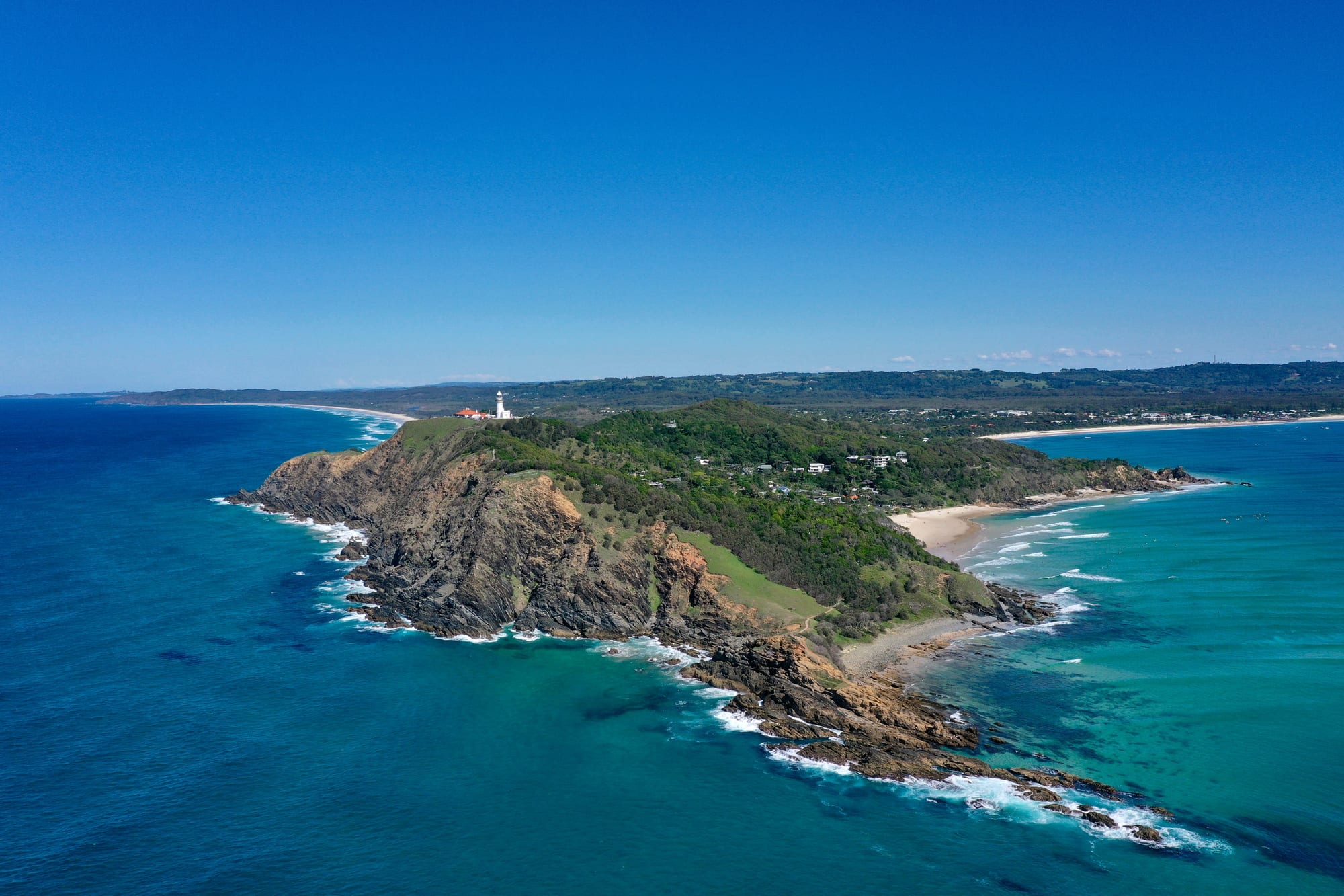
Aerial view of a green headland with a white lighthouse on top, rocky cliffs below and a curving sandy beach and low town behind

Sydney, New South Wales & the ACT, Australia

Byron Bay

Cape Byron and its lighthouse, with the beaches and town of Byron Bay behind. (Kpravin2 / Wikimedia Commons · CC BY-SA 4.0)

A beach town on the far north coast of New South Wales, below the headland of Cape Byron, the most easterly point of mainland Australia. Built on cedar, dairying and whaling, it was remade from the 1970s by surfers and alternative settlers and is now one of the country's best-known holiday towns, with long beaches, a lighthouse walk and high prices.

Neighbourhoods

  • The town centre
    • First-time visitors
    • Best for food
    • Nightlife

    A flat grid of low buildings around Jonson and Bay streets, a couple of minutes from Main Beach. Cafés, surf shops, bakeries, pubs and most of the town's hotels and hostels are here, and almost everything in the centre can be reached on foot.

    Open in Maps
  • Clarkes Beach and The Pass
    • Beaches
    • Surfing
    • Quiet mornings

    The sheltered eastern side of the bay, where the sand curves towards the cape. The Pass, at its far end, is the town's best-known surf break and a long right-hand wave popular with longboarders; the campground and holiday units behind Clarkes Beach sit under pandanus and casuarina.

    Open in Maps
  • Wategos Beach
    • Beaches
    • Quiet and residential
    • Swimming

    A small north-facing beach in a bowl of houses below the lighthouse road, reached by a side turn from the cape. It has no shops, which keeps it calmer than the town beaches, and the walking track to Cape Byron passes above it.

    Open in Maps
  • Suffolk Park
    • Quiet and residential
    • Beaches
    • Value for money

    A residential suburb a few kilometres south of the centre, behind the long sweep of Tallow Beach. It has a small shopping strip and a pub, holiday houses under the trees, and easier parking than the town, with Arakwal National Park between it and the sea.

    Open in Maps
  • Ewingsdale and the hinterland
    • Quiet and residential
    • Countryside
    • Hinterland views

    The farmland west of the town, rising towards the plateau, with macadamia orchards, small guesthouses and the light-industrial Arts and Industry Estate on the way in. A car is needed, and the villages of Bangalow and Newrybar lie just beyond.

    Open in Maps

Things to do

The cape and the beaches

  • Cape Byronviewpoint

    The most easterly point of mainland Australia, circled by a walking track of about four kilometres that climbs through rainforest and open headland from the beaches to the lighthouse.

    Open in Maps
  • Cape Byron Lightlandmark

    The lighthouse of 1901 on the headland, one of the most powerful in Australia, with keepers' cottages, a small display and views along the coast in both directions.

    Open in Maps
  • Arakwal National Parkpark

    Heath, wetland and dune country behind Tallow Beach, created in 2001 under an agreement with the Arakwal Bundjalung people and managed jointly with them.

    Open in Maps
  • Julian Rocksattraction

    A pair of small rocky islands about two and a half kilometres offshore, known to the Arakwal as Nguthungulli, where tropical and temperate currents meet over one of Australia's best-known dive sites.

    Open in Maps
  • Broken Headbeach

    A string of small beaches and rocky points south of Suffolk Park, backed by a nature reserve of rainforest and reached by a road through the bush.

    Open in Maps

Short trips from the town

  • Bangalowneighborhood

    A village of timber shopfronts in the hills about twelve kilometres inland, with restaurants, antique shops, a monthly market and a weekly farmers' market.

    Open in Maps
  • Lennox Headbeach

    A smaller surf town about twenty kilometres south, with a long beach, a right-hand point break at Lennox Point and Lake Ainsworth behind the dunes.

    Open in Maps
  • Mullumbimbyneighborhood

    The old dairy town of the Brunswick Valley, about fifteen kilometres north-west, known for its alternative community, its wide main street and the mountains behind it.

    Open in Maps
  • Nightcap National Parkpark

    Subtropical rainforest on the eroded rim of the ancient Tweed volcano about thirty-five kilometres inland, part of the Gondwana Rainforests of Australia World Heritage listing.

    Open in Maps
  • Minyon Fallsviewpoint

    A waterfall that drops about a hundred metres over a rhyolite cliff into rainforest, with a lookout at the top and a walking track to the base.

    Open in Maps
  • Nimbinneighborhood

    A hinterland village about seventy kilometres away that became a centre of Australian counterculture after the Aquarius Festival was held there in 1973.

    Open in Maps

Seasonal events

  • Humpback whale migrationwinter and spring

    Humpbacks pass close to Cape Byron on their way north to breed and again on the way south with calves, and are often watched from the headland.

  • Byron Writers FestivalAugust

    Talks and readings with Australian and international authors over the first weekend of August.

Eat and drink

Long-standing places and food districts in Byron Bay. Hours, ratings and directions come from your maps app, always current.

Markets

  • Byron Farmers Marketmarket

    A weekly Thursday morning market at the Cavanbah Centre where more than seventy growers from the Northern Rivers sell macadamias, avocados, tropical fruit, coffee, bread and vegetables, with stalls making breakfast on the spot.

    Open in Maps
  • Byron Community Marketmarket

    A market of crafts, clothes, plants and food stalls held on the first Sunday of each month on the same ground, the biggest of several markets that rotate around the shire's towns.

    Open in Maps

Where to eat

  • Jonson Street and the town centreneighborhood

    Bakeries, juice and açaí bars, fish and chips, pizza, Thai and Japanese kitchens and pubs serving food, all within a few blocks of the beach.

    Open in Maps
  • Arts and Industry Estateneighborhood

    A light-industrial estate on the western edge of town where warehouses hold coffee roasters, bakeries, a brewery tasting room and casual cafés used mostly by locals.

    Open in Maps
  • Bangalow and Newrybarneighborhood

    The hinterland villages inland from the coast, where a cluster of restaurants and produce shops cook with macadamias, local beef and tropical fruit from nearby farms.

    Open in Maps

Experience Byron Bay

History

The bay and the headland are Arakwal country, part of the wider Bundjalung nation, and the Arakwal people fished, camped and held ceremonies along these beaches long before Europeans arrived. James Cook named Cape Byron in 1770 after the navigator John Byron, and the name later passed to the town that grew behind it, known first as Cavvanbah.

Cedar cutters worked the rivers of the Northern Rivers district from the middle of the 19th century, and when the big trees were gone the cleared land was turned over to dairy farming. Byron Bay became the district's port: a long jetty ran out into the surf, and butter from a co-operative factory, pigs, timber and sand were loaded onto ships from it. Rail arrived in the 1890s. In the 1950s a whaling station operated at the bay, closing in the early 1960s, and an abattoir and sand mining added to the industry until they too shut down.

By the 1970s the jetty was gone and the town was cheap and half-empty. Longboard surfers had begun arriving in the 1960s for the point breaks at The Pass and Wategos, and after the Aquarius Festival at Nimbin in 1973 alternative settlers moved into the hinterland around it. Guesthouses, markets and music festivals followed through the 1980s and 1990s, the railway closed in 2004, and in the decades since the town has become one of the most expensive places to live in regional Australia, with holiday letting, celebrity buyers and a severe shortage of housing for the people who work there.

Culture & Customs

Surfing is the town's oldest claim on the world. The long right-hand wave at The Pass suits longboards, and the informal, board-shorts style of the place — barefoot in the street, coffee before a morning swim — grew out of the surf culture of the 1960s and 1970s. Alongside it sits a wellness and alternative scene of yoga studios, retreats, healers and vegan kitchens, an inheritance from the communes and co-operatives that settled the hinterland after the Aquarius Festival.

Music and writing hold the calendar together. Festivals on farmland outside the town drew large crowds from the 1990s, the Easter blues and roots festival being the best known until its organisers went into liquidation in 2026, and the writers festival each August still fills its sessions with authors and readers. Markets rotate around the shire's towns through the month, and buskers work the main street most evenings.

Environmental activism is part of local identity: protests in the hinterland rainforest at Terania Creek in 1979 helped stop logging there and led to the protection of the Nightcap ranges. The Arakwal people signed an agreement with the state in 2001 that created Arakwal National Park and gave them a role in managing their country, an arrangement often cited as a model. Residents are proud of the low-rise skyline and wary of the crowds and the attention, and the tension between a small town and a famous destination runs through most local argument.

Daily Life

About six thousand people live in the town itself and around thirty-six thousand in Byron Shire, the local government area that also takes in Mullumbimby, Bangalow and Brunswick Heads. Visitors far outnumber residents through the year, and the population of the centre swells enormously between Christmas and the end of January.

Tourism and hospitality are the main employers, together with wellness and creative businesses, small manufacturers in the Arts and Industry Estate, and farming in the hinterland — macadamias, coffee, avocados, cattle and tropical fruit. The shortage of housing is the dominant local issue: house prices and rents have risen far beyond local wages, many homes are let to holidaymakers rather than residents, and the balance between holiday letting and housing for residents is a long-running point of local argument. Workers commute in from Mullumbimby, Ballina and Lismore, and homelessness is visible for a town of this size.

The day starts early with swimmers, runners and surfers checking the point, and the working week is shaped by the tide, the swell and the weather. Traffic on the single main road, water restrictions in dry spells, and recovery from the 2022 floods that devastated parts of the Northern Rivers are constant subjects of conversation. Winter is the season residents like best, when the town returns to something like its own size.

Food

The Northern Rivers is a productive corner of Australia, and the food in Byron Bay reflects it. Macadamias are native to this coast and grown in orchards just inland; coffee is grown on the plateau above the town; and avocados, bananas, custard apples, finger limes and macadamia oil all come from farms within an hour's drive. The weekly farmers market and the monthly community market are the places to see the range of it.

Café cooking dominates. Breakfast is a serious meal here — eggs, smashed avocado, banana bread, açaí bowls and cold-pressed juice — and the town has an unusually high number of vegetarian, vegan and gluten-free kitchens for its size, a legacy of the wellness scene. Bakeries sell sourdough and sausage rolls to queues of surfers, and fish and chips eaten on the grass above Main Beach is the standard early dinner.

Seafood comes from the trawlers at Ballina and Brunswick Heads: school prawns, mahi-mahi, snapper and mud crab. Native ingredients appear widely, with lemon myrtle, Davidson plum, wattleseed and finger lime used in both restaurant kitchens and market stalls. The town also brews: a brewery based in the town sells its pale ale across the country, and distilleries and small breweries in the estate and the hinterland make gin and beer from local fruit and grain.

Planning tools

Budget

Byron Bay is expensive for a town of its size, and accommodation is the reason: rooms and holiday houses cost as much as in Sydney at Christmas, in January, at Easter and on festival weekends, and far less in late autumn and winter. Eating out is priced for visitors, though bakeries, the markets and the supermarkets keep costs down, and the beaches, the cape walk and the national parks are free.

Daily Budget Midrange
USD 190–330 (mid-range hotel or apartment, café breakfasts and restaurant dinners, a hire car, a surf lesson or dive trip)
Daily Budget Shoestring
USD 80–130 (hostel dorm, self-catering and market food, walking and local buses, beaches and the lighthouse walk)

Book accommodation months ahead for the summer school holidays and Easter; paid parking applies across the town centre and the cape, and a car left overnight in a beach car park is a common target for theft.

Best Time to Visit

The climate is subtropical and the town works year-round. May to October is drier, mild and much quieter, with whales passing the cape through winter and spring. December to February is hot, humid and crowded, with the heaviest rain and the highest prices, and Easter and the school holidays fill the town. September to November is the most settled stretch for swimming and walking.

Suggested Number of Days

Two or three days are enough for the town, the cape and a couple of beaches. Four or five suit visitors who also want the hinterland villages, the rainforest parks and the coast to the north and south, which need a car. Wet weather and surf conditions change plans more than distance does.

First Visit
2–3 days
With Surroundings
4–5 days

Transportation

The town centre is small enough to cross on foot, and bicycles are everywhere. There is no passenger railway: the coastal line closed in 2004 and the old station is now a bus and market space. Regional buses run along the coast to Ballina, Lennox Head, Brunswick Heads and the Gold Coast, and airport shuttles meet flights at Ballina and Coolangatta. A car is needed for the hinterland, but the single main road into town jams in holiday periods and parking is limited and paid.

Parking in the centre and at the cape is metered and often full, so many visitors leave the car at their accommodation and walk or cycle.

Airport & Station Connections

Most visitors fly to Ballina Byron Gateway Airport, about thirty kilometres south, which has domestic flights, or to Gold Coast Airport at Coolangatta, about ninety kilometres north and roughly an hour and a half away by road. Brisbane is about one hundred and sixty-five kilometres north, a drive of a little over two hours, and Sydney is around eight hundred kilometres south, a long day at the wheel or an overnight coach. Shuttle buses and coaches serve all three airports.

Walkability

The centre is flat, compact and almost entirely walkable, with the main beach at the end of the main street. The track around Cape Byron to the lighthouse is about four kilometres and climbs steeply in places; a beach walk runs west past Belongil and south along Tallow Beach for kilometres. Suffolk Park, Ewingsdale and Broken Head are too far to reach comfortably on foot.

Safety

The town is safe, and the real hazards are natural. Surf beaches here have strong rip currents and only some are patrolled; the subtropical sun is fierce; and the Northern Rivers flood, most severely in early 2022, when the region was badly hit. Late-night drinking in the town centre brings occasional trouble, and theft from parked cars and unattended bags on the beach is the commonest crime against visitors.

Swim between the flags on patrolled beaches and ask about rips before entering the water elsewhere, and check flood and fire warnings in summer. Check current official travel advice before travelling.

Climate

A humid subtropical climate, warmer and wetter than Sydney. Seasons are reversed from the northern hemisphere: summer runs from December to February and winter from June to August. Rain falls mainly in the warmer months, often in heavy bursts, and the sea is swimmable most of the year.

Summer
hot and humid from December to February, typically 20–29°C, with heavy showers, thunderstorms and the risk of tropical rain systems
Winter
mild and mostly dry from June to August, typically 11–21°C, with warm sunny days and cool nights

Local Customs

Dress is very casual — swimwear and bare feet are normal in the streets near the beach, though shirts and shoes are expected in restaurants. Tipping is not required. The town has a strong wellness and alternative culture, with yoga studios, retreats and vegan kitchens in the middle of a surf town, and a well-organised environmental movement. Alcohol-free zones cover the beaches and much of the centre, and the land is Arakwal Bundjalung country, acknowledged at public events and in the joint management of the national parks.

Ask before photographing people at the beach or at markets, take rubbish away from the beaches and headland, and leave dunes and nesting shorebird areas alone.

Common Payment Methods

The currency is the Australian dollar. Cards and phone payments work almost everywhere, including at most market stalls, and some cafés take no cash; card surcharges of a percent or two are common and must be displayed. ATMs are in the town centre, and prices include the ten per cent goods and services tax.