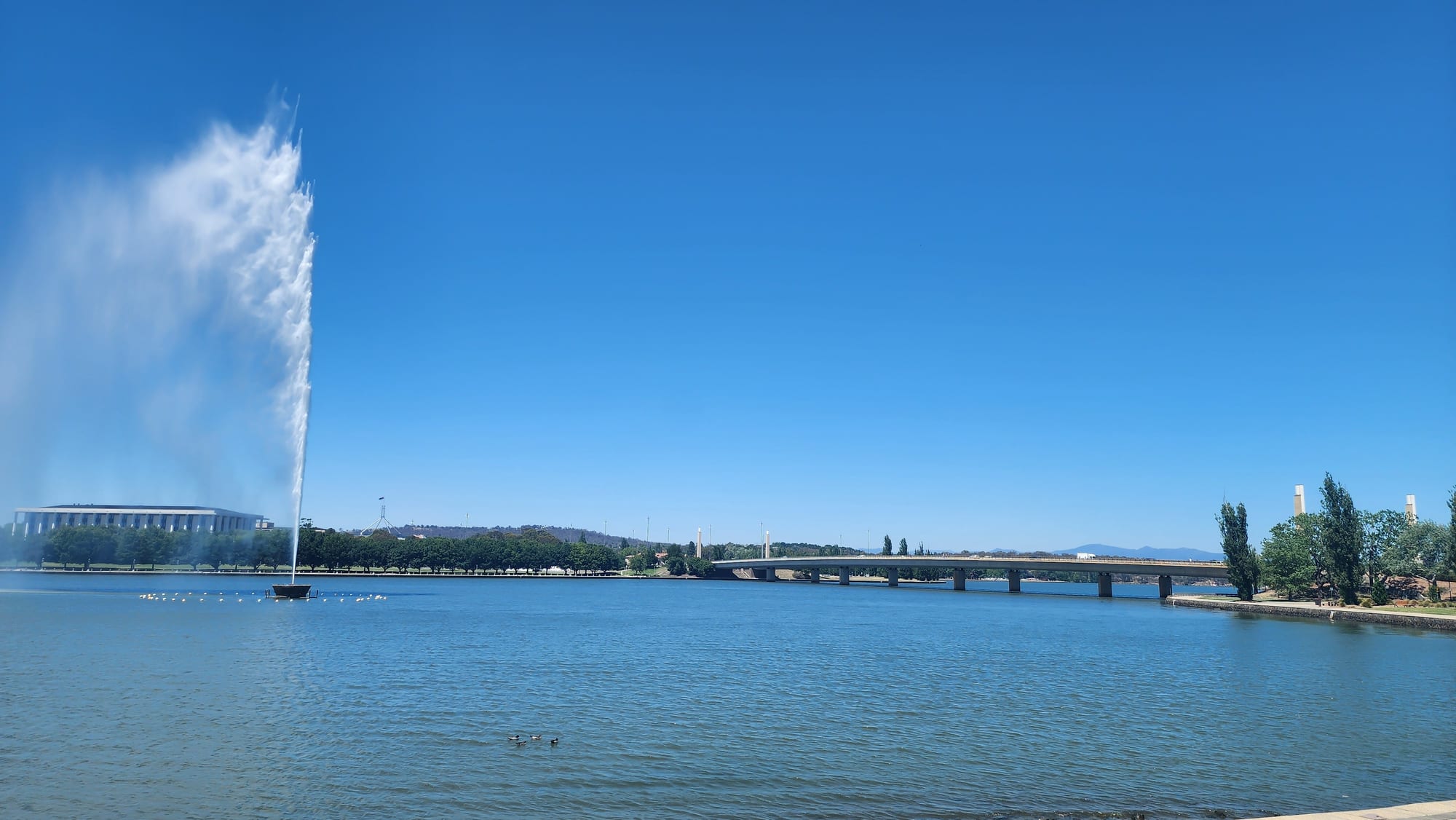
A tall plume of water rising from a blue lake, with a low colonnaded building on the far shore and a long road bridge beyond

Sydney, New South Wales & the ACT, Australia

Canberra

The Captain Cook Memorial Jet on Lake Burley Griffin in central Canberra. (Shkuru Afshar / Wikimedia Commons · CC BY-SA 4.0)

Australia's capital, built from nothing on inland sheep country after the states could not agree between Sydney and Melbourne. Laid out to a 1912 design by Walter Burley Griffin and Marion Mahony Griffin around an artificial lake, it holds the federal parliament and the national museums, galleries and archives, and has about 485,000 residents spread across low, green suburbs.

Neighbourhoods

  • Civic
    • First-time visitors
    • Shopping
    • Close to public transport

    The commercial centre, north of the lake, known to everyone as Civic rather than by its official name of City. Offices, department stores, cinemas, the bus interchange and the light rail terminus sit around Garema Place and the Sydney and Melbourne buildings, a pair of arcaded blocks begun in the 1920s.

    Open in Maps
  • Braddon
    • Best for food
    • Nightlife
    • Cafés

    Canberra's first light-industrial area, next to Civic, remade around Lonsdale Street into the city's busiest strip of restaurants, bars, breweries and coffee shops. Flats above the shops have made it one of the few parts of Canberra where people walk to dinner.

    Open in Maps
  • Acton and the university
    • Students
    • Lakeside walks
    • Arts and culture

    The wooded peninsula between Civic and the lake, occupied by the Australian National University, the film and sound archive and a small arts and hotel precinct at New Acton. Paths run from the campus to the water and around to the botanic gardens on Black Mountain.

    Open in Maps
  • Parkes and the Parliamentary Triangle
    • Museums
    • Landmarks
    • Lakeside walks

    The formal heart of the Griffin plan, between the lake and Capital Hill, where Parliament House, the high court, the national gallery, library and portrait gallery stand among lawns and set-back avenues. Almost nobody lives here, and it is quiet in the evenings.

    Open in Maps
  • Kingston and the Kingston Foreshore
    • Best for food
    • Waterfront walks
    • Close to public transport

    Canberra's oldest suburb, south-east of the lake, with a small shopping centre and, on reclaimed land beside the water, a dense new quarter of flats, restaurants and bars along the Kingston Foreshore boardwalk.

    Open in Maps
  • Manuka
    • Best for food
    • Quiet and residential
    • Sport

    A leafy shopping village south of the lake, among the large gardens of the inner south, with restaurants and cafés around a small square, a cinema, and the cricket and football ground of Manuka Oval a block away.

    Open in Maps
  • Dickson
    • Best for food
    • Value for money
    • Close to public transport

    A suburban centre a few kilometres north of Civic on the light rail line, built around a group shopping centre: a strip of shops, grocers, small restaurants and offices, with a library known for its design among them, and cheaper eating than the inner city.

    Open in Maps

Things to do

The Parliamentary Triangle

  • Parliament Houselandmark

    The federal parliament, opened in 1988 on Capital Hill under a grass-covered roof and a tall flagpole, with public galleries above both chambers and a marble foyer open to visitors.

    Open in Maps
  • Old Parliament Housemuseum

    The white provisional parliament of 1927, used for sixty-one years and now the Museum of Australian Democracy, with the chambers and party rooms kept as they were.

    Open in Maps
  • National Gallery of Australiamuseum

    The national art collection, opened in 1982, strong in Aboriginal and Torres Strait Islander art, Australian painting and international modernism, with a sculpture garden beside the lake.

    Open in Maps
  • National Portrait Gallerymuseum

    Portraits of Australians in a well-regarded building of 2008 near the lake, arranged to tell the country's story through individual faces.

    Open in Maps
  • National Library of Australiamuseum

    A colonnaded building on the lakeshore holding the national collection of books, maps, newspapers and photographs, with free exhibitions drawn from the archives.

    Open in Maps
  • Questaconmuseum

    The national science and technology centre, built for hands-on exhibits and demonstrations and aimed particularly at children.

    Open in Maps
  • Aboriginal Tent Embassylandmark

    A protest camp set up on the lawn opposite Old Parliament House in 1972 to campaign for Aboriginal land rights and sovereignty, and later added to the national heritage list.

    Open in Maps

Museums, memorials and institutions

  • Australian War Memorialmuseum

    A shrine, archive and military museum at the head of Anzac Parade, opened in 1941, with the Roll of Honour, the Hall of Memory and a daily Last Post ceremony.

    Open in Maps
  • National Museum of Australiamuseum

    On the Acton peninsula, telling Australian social and Indigenous history through objects, in a much-debated building of 2001.

    Open in Maps
  • Royal Australian Mintattraction

    The mint that strikes the country's circulating coins, opened in 1965 in the run-up to decimal currency, with displays on coin design.

    Open in Maps
  • National Film and Sound Archivemuseum

    The national collection of film, radio and recorded sound, in an Art Deco former institute of anatomy at Acton, with screenings and exhibitions.

    Open in Maps
  • Australian Institute of Sportattraction

    The national sports training centre at Bruce, founded in 1981 after poor Olympic results, with an arena, pool and laboratories used by elite athletes.

    Open in Maps

The lake, parks and viewpoints

  • Lake Burley Griffinpark

    The artificial lake at the centre of the city, filled in the 1960s by damming the Molonglo River, ringed by cycle paths, lawns and rowing clubs.

    Open in Maps
  • National Carillonlandmark

    A concrete bell tower of 1970 on an island in the lake, given by Britain for the city's jubilee, with recitals heard across the central basin.

    Open in Maps
  • Australian National Botanic Gardenspark

    Gardens on the slope of Black Mountain devoted entirely to Australian native plants, with a rainforest gully and a eucalypt lawn.

    Open in Maps
  • National Arboretum Canberrapark

    Forests and gardens of rare and symbolic trees planted from 2005 as part of the recovery from the 2003 bushfires, on a hill west of the lake with wide views over the city.

    Open in Maps
  • Mount Ainslieviewpoint

    The hill behind the war memorial, reached by road or by a bush track, giving the view down Anzac Parade and along the land axis of the Griffin plan.

    Open in Maps

Short trips from the city

  • Tidbinbilla Nature Reservepark

    A valley reserve a short drive south-west of the city, home to kangaroos, wallabies, emus, koalas and platypus, with walking tracks and granite boulders.

    Open in Maps
  • Canberra Deep Space Communication Complexattraction

    A NASA tracking station near Tidbinbilla, opened in 1965, whose large dish antennas talk to spacecraft across the solar system, with a visitor centre and displays on its part in tracking the Apollo lunar module.

    Open in Maps
  • Namadgi National Parkpark

    Mountain bushland covering the southern half of the territory, with Aboriginal rock art sites, alpine bogs and peaks above 1,800 metres.

    Open in Maps
  • Mount Stromlo Observatoryattraction

    The Australian National University's hilltop observatory west of the city, largely destroyed in the 2003 bushfires and rebuilt as a research and teaching site.

    Open in Maps

Seasonal events

  • SummernatsJanuary

    A street-car festival at Exhibition Park that fills the city with modified cars, burnout competitions and noise for four days.

  • National Multicultural FestivalFebruary

    Three days of food stalls, music and dance in the streets of Civic, run by the territory government and drawing very large crowds.

  • Enlighten FestivalMarch

    Projections on the facades of the national institutions, late openings, night markets and a hot-air balloon gathering over the lake.

  • Anzac Day25 April

    The national day of commemoration, marked by a dawn service and a march at the Australian War Memorial.

  • FloriadeSeptember to October

    A spring flower festival in Commonwealth Park, with a million bulbs planted in beds beside the lake.

Eat and drink

Long-standing places and food districts in Canberra. Hours, ratings and directions come from your maps app, always current.

Food districts

  • Lonsdale Street, Braddonneighborhood

    The busiest eating street in the city, with brewpubs, wine bars, bakeries, pizza and Asian kitchens in converted warehouses and new blocks.

    Open in Maps
  • Dicksonneighborhood

    A suburban shopping precinct north of the centre, where a strip of small restaurants, takeaways and grocers makes a cheaper alternative to the inner-city districts.

    Open in Maps
  • Kingston Foreshoreneighborhood

    A boardwalk of restaurants, cafés and bars beside the water in the newest part of Kingston, busy on summer evenings and at weekend brunch.

    Open in Maps
  • Manukaneighborhood

    An older, quieter restaurant village in the inner south, with pavement tables, a cinema and long-established cafés around a small square.

    Open in Maps

Markets

  • Capital Region Farmers Marketmarket

    A large weekly growers' market at Exhibition Park selling produce from the tablelands and the coast — vegetables, meat, cheese, bread, honey and cool-climate fruit.

    Open in Maps
  • Fyshwick Fresh Food Marketsmarket

    A long-standing covered market in the industrial suburb of Fyshwick, with greengrocers, butchers, a fishmonger, delicatessens and food stalls.

    Open in Maps

Experience Canberra

History

The Limestone Plains are Ngunnawal country, and Ngambri and other groups also hold connections to the valley; ceremonial gatherings once drew people here for the summer bogong moth harvest in the mountains. European graziers arrived in the 1820s, and one of their properties carried a version of the local name that would eventually be given to the city.

Federation in 1901 left the new nation without a capital, because Sydney and Melbourne could not be reconciled: the constitution settled the argument by requiring a federal territory in New South Wales, at least a hundred miles from Sydney. The Limestone Plains site was chosen in 1908 and an international design competition was won in 1912 by the Chicago architects Walter Burley Griffin and Marion Mahony Griffin, whose plan set the city on geometric axes between three hills. The name was announced in 1913. Griffin fell out with the bureaucracy and left in 1920, the First World War and the Depression stalled construction, and for decades Canberra was a scattering of buildings among sheep paddocks. Parliament moved from Melbourne in 1927 into a provisional building.

Serious building came after 1957, when a development commission was given the job of finishing the city; the Molonglo River was dammed and Lake Burley Griffin filled in 1963 and 1964, and the national institutions followed. The present Parliament House opened in 1988, and the territory was granted self-government in 1988, with its first assembly elected the following year. On 18 January 2003 a firestorm reached the western suburbs, killing four people and destroying more than five hundred houses.

Culture & Customs

Canberra's culture grows out of what it was built for. The national museums, galleries, library and archives give a city of under half a million the collections of a much larger one, and free entry makes them part of ordinary weekend life rather than a tourist circuit. The Australian National University, the University of Canberra and smaller campuses of other universities give the city one of the most highly educated populations in the country, and a steady turnover of students, diplomats and public servants keeps it outward-looking.

The rhythm of the year is political. Parliamentary sitting weeks fill the hotels and restaurants; recesses empty them. Residents are used to being a national punchline — Canberra as a synonym for bureaucracy, and a city said to be boring — and answer with the bush on the doorstep, short commutes and the festivals: hot-air balloons over the lake in autumn, the flower beds of spring, a multicultural festival that shuts the streets of Civic, and a modified-car festival in January that is the opposite of the city's image.

Sport is followed through the Raiders in rugby league and the Brumbies in rugby union, and cycling is popular, helped by a city-wide network of paths. Aboriginal politics has a national stage here: the Tent Embassy has stood opposite Old Parliament House since 1972, and marches and ceremonies converge on the parliamentary zone. The territory's assembly has often legislated ahead of the states, including on the personal possession of cannabis.

Daily Life

About 485,000 people live in Canberra, which is nearly the whole population of the Australian Capital Territory, and the city is really a set of districts — the inner north and south, Belconnen, Woden, Weston Creek, Tuggeranong and Gungahlin — each built around its own town centre and separated by ridges of bushland. Nearly everyone drives, commutes are short by Australian standards, and the suburbs are low, green and quiet, with kangaroos grazing on the reserves between them.

The Commonwealth public service is the largest employer, with universities, hospitals, defence, construction and a growing technology and cyber-security sector alongside it. Median incomes are higher than in any state capital and unemployment is usually below the national rate; housing is expensive though below Sydney, and the city has been building flats along the light rail and around the town centres rather than spreading further outwards.

Life is shaped by the seasons more than in coastal cities. Winter mornings begin below freezing, with fog over the lake and frost on the cars; summer is dry, and the smoke of the 2019 to 2020 fire season, followed by a destructive hailstorm, is a shared memory. Weekends go to sport, markets, the lake and the reserves, and long weekends empty the city towards the South Coast beaches or, in winter, the snowfields two hours south.

Food

For a city so often described as having no character, Canberra eats well, and the reason is the country around it. The weekly farmers market at Exhibition Park brings in produce from the southern tablelands and the coast: lamb and beef from the Monaro, cheese, cool-climate apples and cherries, honey and vegetables. The Fyshwick Fresh Food Markets, in the light-industrial suburb east of the centre, keep the same trade going through the week.

Wine comes from the Canberra District, planted on the hills around Murrumbateman and Lake George just over the border in New South Wales, and known for riesling and cool-climate shiraz; cellar doors are a short drive from the city, and their wines dominate local lists. The craft brewing scene is unusually strong for the size of the city, concentrated in Braddon and the industrial suburbs.

Everyday eating divides by district. The suburban shopping precincts, Dickson among them, hold the strips of small restaurants, takeaways and grocers where prices are lowest. Braddon and the Kingston Foreshore hold the newer restaurants, brewpubs and weekend brunch trade, while Manuka and Barton keep the long-established dining rooms where politicians and lobbyists are spotted. The national multicultural festival in February turns the centre into a street food market representing scores of countries, and it is the best single display of what the city actually eats.

Planning tools

Budget

Canberra is cheaper than Sydney, but its hotel market runs on government and conference travel, so rooms cost most from Monday to Thursday when Parliament sits and drop at weekends and over January. Most of the national museums and galleries are free to enter, with charges only for special exhibitions, which keeps sightseeing costs low. Restaurants in Braddon, Kingston and Manuka are priced like a capital city; Dickson and the food courts are much cheaper.

Daily Budget Midrange
USD 170–300 (hotel room, restaurant meals, a hire car or taxis, a paid exhibition or two)
Daily Budget Shoestring
USD 85–135 (hostel or budget motel, self-catering and food courts, buses and light rail, the free national collections)

Weekends are the cheap time to visit, the reverse of most Australian cities, and the big national institutions ask no entry fee.

Best Time to Visit

Spring, from September to November, is the most popular season, mild and full of blossom, with the flower festival beside the lake. Autumn, from March to May, brings cold mornings, still days and the colour of the city's planted exotic trees, along with balloons over the lake. Summer is hot and dry and can bring bushfire smoke; winter is cold, foggy and clear, and the museums are at their quietest.

Suggested Number of Days

Two or three days are enough for the national institutions and the lake, as long as some transport is arranged between them. Four or five allow the reserves and mountains in the territory and the wine country over the border. Museum fatigue, rather than distance, is what usually decides the length of a visit.

First Visit
2–3 days
With Surroundings
4–5 days

Transportation

Canberra was planned around the car, and its districts are separated by parkways and open hills, so distances feel long. A light rail line runs from Civic north to Gungahlin, and buses radiate from Civic and the town centres to the suburbs, with services thinning at weekends. A city-wide network of cycle paths links the lake, the ridges and most suburbs. Taxis and ride-hailing work in the inner city, and many visitors hire a car for the reserves and the wineries.

Parking is paid on weekdays in Civic and the parliamentary zone and mostly free at weekends; kangaroos come onto suburban roads at dawn and dusk, when collisions are common.

Airport & Station Connections

Canberra Airport lies about eight kilometres east of the centre, with flights from Sydney, Melbourne, Brisbane, Adelaide, Perth and the Gold Coast, and occasional international services. Sydney is about 280 kilometres away, roughly three hours by road, or by train from Central station; Melbourne is about 650 kilometres, roughly seven hours by road. Coaches run from both cities, and the New South Wales South Coast is about two hours east over the escarpment.

Walkability

Each district is walkable inside itself — Civic, Braddon, Kingston and Manuka are all easy on foot — but the spaces between them are not. The Parliamentary Triangle looks compact on a map and is not: the walk from Parliament House to the war memorial is several kilometres, across the lake, and the institutions sit far back from the road behind lawns. The lake paths, by contrast, make excellent walking and cycling, with bridge to bridge loops of five to ten kilometres.

Safety

Canberra is one of the safest cities in Australia, with low rates of violent crime and little to avoid after dark beyond the usual care around late-night drinking areas. The hazards are environmental: summer heat and high ultraviolet levels, bushfire and the smoke that blanketed the city in the summer of 2019 to 2020, severe hailstorms, frost and fog on winter roads, and kangaroos on the edges of the suburbs.

Drive slowly on suburban and country roads at dawn and dusk because of kangaroos, and check fire danger ratings before walking in the reserves in summer. Check current official travel advice before travelling.

Climate

An inland climate with four clear seasons, at about 580 metres above sea level and well away from the sea. Seasons are reversed from the northern hemisphere: summer runs from December to February and winter from June to August. Days are dry and sunny for much of the year, with a big difference between day and night temperatures.

Summer
hot and dry from December to February, typically 13–28°C, with spells above 35°C, thunderstorms and the risk of bushfire smoke
Winter
cold from June to August, typically 0–12°C, with heavy frosts, morning fog and snow on the ranges nearby rather than in the city

Local Customs

This is a public-service city, and politics is ordinary shop talk rather than a spectacle; the working week follows the parliamentary sitting calendar, and much of the inner city empties at weekends. Dress is business-like on weekdays and casual otherwise, and tipping is not required. Canberra is Ngunnawal country, acknowledged at public events, and Aboriginal political history is unusually visible here. Anzac Day and the daily Last Post ceremony at the war memorial are treated with real solemnity.

Expect airport-style screening to enter Parliament House, stay quiet and still during ceremonies at the war memorial, and ask before photographing people at protests or memorials.

Common Payment Methods

The currency is the Australian dollar. Cards and phone payments are taken everywhere, including on light rail and buses, and card surcharges of a percent or two are common. Cash is rarely needed beyond market stalls. ATMs are in the town centres, and displayed prices include the ten per cent goods and services tax.