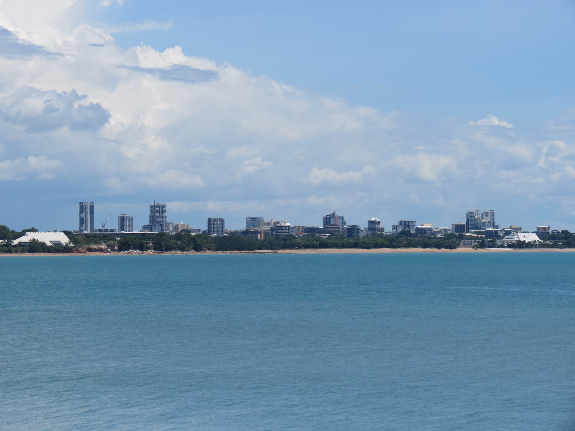
Darwin's low white towers along a wooded shore, seen across flat blue harbour water under tropical cloud

The Northern Territory, Australia

Darwin

The Darwin skyline seen across the harbour from East Point, Northern Territory. (Ken Hodge / Wikimedia Commons · CC BY 2.0)

Australia's northernmost capital, on a harbour opening to the Timor Sea, closer to Indonesian and Timorese ports than to Sydney. Larrakia country, and a telegraph and gold town from 1869, it was bombed by Japanese aircraft in 1942 and flattened by Cyclone Tracy in 1974. Rebuilt twice, it is now a young, humid, unusually multicultural city of markets and dry-season festivals.

Neighbourhoods

  • Darwin City
    • First-time visitors
    • Nightlife
    • Close to public transport

    The compact centre on a headland above the harbour, holding most of the hotels, the pedestrianised Smith Street Mall, the bars and backpacker lodges of Mitchell Street, and the government and colonial buildings along the Esplanade. Almost everything in the city centre is within a twenty-minute walk.

    Open in Maps
  • The Waterfront
    • Families
    • Swimming
    • Restaurants

    A redeveloped wharf area below the city centre, reached by lift and footbridge, built around a wave pool and a netted saltwater lagoon that give safe swimming away from crocodiles and stingers. Hotels, apartments, restaurants and the convention centre stand around the water.

    Open in Maps
  • Larrakeyah and the Esplanade
    • Sunset views
    • Quiet and residential
    • Historic district

    The green western edge of the centre, where the Esplanade runs above the sea past Bicentennial Park, war memorials and Government House. Older flats and houses sit between the army barracks and the harbour, and the Deckchair Cinema is tucked below the cliff at Doctors Gully.

    Open in Maps
  • Cullen Bay
    • Restaurants
    • Boats and ferries

    A marina suburb a short way north-west of the centre, built around a lock that keeps the tide out. Waterside restaurants and cafés look over the moored boats, and the ferries across the harbour to Mandorah and out to the Tiwi Islands leave from here.

    Open in Maps
  • Parap and Fannie Bay
    • Best for food
    • Markets
    • Local life

    Two older inner suburbs a few kilometres north of the centre. Parap has a small shopping village and the Saturday market famous for its laksa; Fannie Bay beyond it runs down to the sea at Mindil and Vesteys beaches, with the museum, the old gaol and the sailing clubs along the shore.

    Open in Maps
  • Nightcliff and the northern suburbs
    • Quiet and residential
    • Beaches
    • Cafés

    Where most of Darwin lives, spread along the coast from Coconut Grove to Casuarina about ten kilometres from the centre. A foreshore path follows the low red cliffs past a jetty, a pool and a Sunday market, and Casuarina has the area's largest shopping centre and a long beach reserve.

    Open in Maps
  • Palmerston
    • Quiet and residential
    • Family stays

    A separate satellite city about twenty kilometres east, built from the 1980s and now home to a large share of the Darwin area's residents. It is mostly suburban housing, schools and shopping centres, and is convenient for the highway south towards the national parks.

    Open in Maps

Things to do

Wartime and historic Darwin

  • Darwin Military Museummuseum

    At East Point, around the concrete gun emplacements built to defend the harbour, with an immersive account of the 1942 bombing raids.

    Open in Maps
  • WWII Oil Storage Tunnelsattraction

    Tunnels driven into the rock near the wharf from 1943 to keep fuel safe from bombing after the tanks on Stokes Hill were destroyed. Only six were finished and none ever held oil; two are open to visitors.

    Open in Maps
  • Fannie Bay Gaolmuseum

    The Territory's main prison from 1883 until 1979, kept as a museum of cell blocks, gallows and the damage left by Cyclone Tracy.

    Open in Maps
  • Government Houselandmark

    The oldest European building in the Territory, built in 1870 and 1871 above the harbour and repaired after cyclones, earthquakes and wartime raids, a mid-Victorian villa with shaded verandahs in hillside gardens.

    Open in Maps
  • Christ Church Cathedrallandmark

    A cathedral completed in 1977 on the Esplanade, built around the porch that survived the destruction of the earlier church by Cyclone Tracy in 1974.

    Open in Maps
  • Brown's Martlandmark

    Built in 1885 as a mining exchange and used since for auctions, meetings, banking and the arts, it is one of the oldest buildings left in the city centre and now a theatre.

    Open in Maps

Museums and galleries

  • Museum and Art Gallery of the Northern Territorymuseum

    The Territory's main museum, at Bullocky Point on the sea, strong on Aboriginal art from Arnhem Land and the Tiwi Islands, home of the national Aboriginal and Torres Strait Islander art award and of the preserved saltwater crocodile called Sweetheart.

    Open in Maps
  • Darwin Aviation Museummuseum

    A hangar at Winnellie holding wartime and civil aircraft, including a United States Air Force B-52 bomber.

    Open in Maps

Parks, beaches and the harbour

  • George Brown Darwin Botanic Gardenspark

    Gardens established on this site in 1886 between the centre and Mindil Beach, holding a major collection of northern Australian monsoon flora, from mangroves and vine thicket to Tiwi Islands wet forest.

    Open in Maps
  • East Point Reservepark

    A headland of monsoon forest and wartime batteries north-west of the centre, with cycling and walking paths and the artificial Lake Alexander, which is safe for swimming all year.

    Open in Maps
  • Charles Darwin National Parkpark

    Bushland and wartime concrete bunkers on an arm of the harbour a few kilometres from the centre, one bunker holding a visitor centre and wartime display, with lookouts back to the city.

    Open in Maps
  • Casuarina Coastal Reservepark

    Eight kilometres of sandy beach backed by casuarina trees and sandstone cliffs along the northern suburbs, the main stretch of coast for walking at the city's edge.

    Open in Maps
  • Mindil Beachbeach

    The curve of sand west of the centre where much of the city gathers to watch the sun set over the sea, though the water is not safe for swimming.

    Open in Maps
  • Darwin Waterfront Precinctattraction

    The old wharf area turned into a public space, with a wave lagoon, a netted swimming lagoon, boardwalks and restaurants below the city centre.

    Open in Maps

Markets, wildlife and evenings out

  • Mindil Beach Sunset Marketmarket

    A large market of food stalls, crafts and buskers held behind Mindil Beach on Thursday and Sunday evenings through the dry season, with the crowd drifting onto the sand as the sun goes down.

    Open in Maps
  • Crocosaurus Coveattraction

    A crocodile centre in the middle of the city, with saltwater crocodiles in glass tanks, reptile displays and a cage lowered into a crocodile pool.

    Open in Maps
  • Deckchair Cinemaattraction

    An open-air cinema on the harbour below the Esplanade, screening independent and arthouse films from about April to October.

    Open in Maps

Short trips from the city

  • Litchfield National Parkpark

    About a hundred kilometres south-west, a plateau of plunging waterfalls, clear swimming holes at Wangi and Florence Falls, and fields of thin magnetic termite mounds.

    Open in Maps
  • Territory Wildlife Parkattraction

    At Berry Springs south of the city, a large open park of Top End habitats with an aquarium, a billabong, a nocturnal house and a walk-through aviary.

    Open in Maps
  • Tiwi Islandsattraction

    Bathurst and Melville islands north of Darwin, Tiwi-owned and reached by ferry or light aircraft, known for their art centres, carved burial poles and football.

    Open in Maps

Seasonal events

  • Bombing of Darwin commemorationFebruary

    A memorial service at the Cenotaph on the Esplanade each 19 February, marking the 1942 air raids with a siren sounded across the city.

  • Darwin Triple Crowndry season

    A round of the Australian Supercars championship at the Hidden Valley circuit, held there since 1998 and one of the Territory's biggest sporting weekends.

  • Territory DayJuly

    The anniversary of self-government on 1 July, the one day of the year when Territorians may buy and set off their own fireworks.

  • Darwin Cup CarnivalJuly and August

    Weeks of horse racing at Fannie Bay Racecourse ending with the Darwin Cup on the first Monday of August, a Territory public holiday and a dress-up occasion for the whole city.

  • Darwin FestivalAugust

    The city's arts festival, eighteen days of outdoor concerts, theatre, comedy, cabaret, film and Aboriginal performance at venues around town.

  • Beer Can Regattadry season

    Races at Mindil Beach in boats built from empty drink cans, first held in 1974 to clear beer cans from the streets, alongside thong-throwing, sandcastles and a novelty hat contest.

Eat and drink

Long-standing places and food districts in Darwin. Hours, ratings and directions come from your maps app, always current.

Markets and food streets

  • Parap Village Marketmarket

    A Saturday-morning market in the old suburb of Parap, best known for laksa eaten standing up, alongside Thai, Filipino, Indonesian and Sri Lankan stalls and tropical fruit.

    Open in Maps
  • Rapid Creek Marketmarket

    A long-running market held in a shed in the northern suburbs, half Asian grocery and half cooked food, with herbs, greens and fruit grown on rural blocks.

    Open in Maps
  • Nightcliff Marketmarket

    A weekend market by the Nightcliff foreshore, more crafts and second-hand stalls than the others, with coffee, curries and fresh juice.

    Open in Maps
  • Mindil Beach Sunset Marketmarket

    The big dry-season evening market, where the food stalls run to satay, laksa, Timorese and Greek dishes, and crocodile and buffalo for the curious.

    Open in Maps

The harbour and the wharves

  • Stokes Hill Wharfneighborhood

    A working wharf lined with casual seafood counters, where barramundi and chips eaten at an outdoor table as the sun drops behind the harbour is a long-standing Darwin habit.

    Open in Maps
  • Darwin Waterfrontneighborhood

    Restaurants and bars around the swimming lagoons below the centre, the easiest place to eat within walking distance of the city hotels.

    Open in Maps
  • Cullen Bayneighborhood

    A marina strip of seafood and modern Australian restaurants looking over moored boats, busiest at sunset.

    Open in Maps

Bars and cafés

  • Mitchell Streetneighborhood

    The city centre's pub and bar strip, running from the hotels to the backpacker lodges, noisy and busy through the dry season.

    Open in Maps

Experience Darwin

History

Darwin stands on the country of the Larrakia people, whose lands take in the harbour and the coast around it. Makassan and European ships had passed along the coast for a long time before John Clements Wickham of HMS Beagle named the harbour Port Darwin in 1839, after the naturalist Charles Darwin, who had sailed with the ship on an earlier voyage. A permanent settlement followed in 1869, when the South Australian surveyor George Goyder laid out a town called Palmerston on the headland above the water.

Two things made it grow. The Overland Telegraph line, completed in 1872, joined the town by undersea cable to Java and so to London; and gold found inland at Pine Creek in the 1880s drew large numbers of Chinese labourers, contracted to work the goldfields and later to build the railway towards Pine Creek, who established the town's Chinatown. Pearling, cattle and the railway south followed. The Commonwealth took over the Territory in 1911 and the town was renamed Darwin.

On 19 February 1942 Japanese aircraft attacked the harbour and the airfields in the largest attack ever mounted by a foreign power on Australia, sinking ships in the harbour and killing about 250 people by the estimate of the commission that investigated it, with later counts higher. All but about 2,000 civilians had already left, dozens of further raids followed over the next two years, and the town became a military base.

Darwin was rebuilt after the war, and then destroyed again. Cyclone Tracy crossed the city in the early hours of 25 December 1974, killing about 66 people and leaving most houses uninhabitable; tens of thousands of residents were flown south, and many never returned. The city was rebuilt to far stricter cyclone standards, and has grown steadily since the Territory gained self-government in 1978.

Culture & Customs

Darwin is one of the most mixed cities in Australia. The Larrakia are the traditional owners, and Aboriginal people from across the Top End, Arnhem Land and the Tiwi Islands come to the city for work, sport, medical care and family; art centres in those regions sell through Darwin galleries, and Australia's longest-running award for Indigenous artists is held at the museum each year. Chinese families have been here since the goldfields of the 1870s, and a Chinese temple founded in 1887 still stands in the centre. Greek, Filipino, Indonesian, Timorese, Thai, Vietnamese and Indian communities each hold their own celebrations, among them the Greek Glenti and India@Mindil.

Life is lived outdoors and informally. Shorts and sandals are ordinary dress almost everywhere, work starts early to beat the heat, and the dry season fills the calendar with markets, open-air films, football and the Darwin Festival in August. Residents describe the year in two halves and talk about the build-up, the sticky, stormy weeks before the monsoon that are said to fray tempers. Australian rules football is the main sport, and the Territory league plays through the wet season rather than the southern winter, with Tiwi Islands teams closely followed.

The city looks north as much as south. It is nearer to Dili and to Bali than to Sydney, trades and studies across the Timor Sea, and hosts a rotation of up to 2,500 United States Marines for six months of each year. The Beer Can Regatta at Mindil Beach, raced in boats built from empty cans, catches the local sense of humour.

Daily Life

About 140,000 people live in Greater Darwin, including the satellite city of Palmerston and the rural blocks around Humpty Doo, which makes it the smallest and the most northerly of the Australian capitals. The population is young, and it turns over quickly: defence postings, public service contracts and mining and construction work bring people for a few years and take them away again.

Most residents live in the northern suburbs between Nightcliff and Casuarina, in Palmerston, or on large blocks in the rural area, while the older suburbs of Parap, Fannie Bay and Stuart Park sit closest to the centre. Houses are built high, louvred and to cyclone standards, and households expect to check their emergency supplies at the start of the wet season.

The economy rests on the port and the gas industry on the harbour, on defence — the air force base shares the airport runway, with army barracks at Larrakeyah and near Palmerston — and on government administration, tourism, construction and services for remote communities. Charles Darwin University is based in the city, which is also the supply and transport base for the whole Territory.

Heat sets the rhythm of the day. Markets, sport and exercise happen early or at dusk and afternoons belong to air conditioning. Living costs are high, housing and rental shortages are a constant political subject, and so are homelessness, alcohol restrictions and the gap in health and housing between Aboriginal and other Territorians.

Food

Darwin eats from the sea and from Asia. Barramundi, a large native fish, is the standard local catch, grilled or battered; mud crab, often cooked with chilli, and banana prawns come from the same waters; crocodile and water buffalo appear on menus more as curiosities than staples.

The city's own dish is laksa, the South-East Asian noodle broth brought by migrant families and now the city's favourite meal, queued for at the Parap and Rapid Creek markets on market mornings. Satay, Filipino barbecue, Thai green papaya salad, Indonesian and Timorese dishes and Greek sweets share the stalls at the Mindil Beach Sunset Market, which sets up behind the sand through the dry season.

Mangoes grown on Top End farms reach the city before the build-up, and mango smoothies and ice cream mark the season. Rambutan, jackfruit, dragon fruit and papaya are grown on rural blocks and reach the markets in the wet. Native bush foods, above all the Kakadu plum, a small green fruit very high in vitamin C, are harvested by Aboriginal enterprises and turned into jams, sauces and drinks.

Barramundi and chips eaten at an outdoor table on Stokes Hill Wharf as the sun drops is a standing local habit, with a cold beer afterwards; the Darwin Stubby, a 2.25-litre bottle, survives mainly as a souvenir. Coffee shops have taken hold in Parap and Nightcliff, and the Waterfront and Cullen Bay hold the more expensive restaurants.

Planning tools

Budget

Darwin is expensive for a city of its size, because much of its food, fuel and building material is freighted in. Room rates rise sharply through the dry season, from about May to September, and again for the Darwin Festival and race carnival; the wet season is much cheaper. Tours to the national parks, harbour cruises and a hire car are the other large costs, while the markets, beaches and lagoons keep daily spending down.

Daily Budget Midrange
USD 190–330 (hotel or serviced apartment, restaurant meals, a cruise or wildlife park, a hire car)
Daily Budget Shoestring
USD 70–120 (hostel dorm in the centre, market meals and self-catering, city buses)

Book dry-season accommodation and any Tiwi Islands or Arnhem Land trip well ahead, and treat the swimming lagoons, the Esplanade, the botanic gardens and the sunset markets as the free core of a visit.

Best Time to Visit

May to September, the dry season, is when the weather is warm and rainless, the markets and outdoor cinema run, and roads to the waterfalls are open. October to December brings the humid 'build-up' and thunderstorms; the wet season from December to March is hot, green and stormy, with heavy rain, a cyclone risk and far fewer visitors.

Suggested Number of Days

Two or three days is enough for the city itself, which is small and easily covered. Five to seven days allows the national parks and wetlands within reach by road, and longer if a trip to the islands or a remote community is added. The wet season shortens what is possible.

First Visit
2–3 days
With Surroundings
5–7 days

Transportation

Public buses run from the interchange on Harry Chan Avenue in the centre to Palmerston, Casuarina and the rural area, frequently on weekdays and less so at weekends. Taxis and ride-hailing work in the built-up area. Most visitors hire a car, because the sights outside the city are spread along the highways, and a four-wheel drive is needed for some park tracks. A passenger ferry crosses the harbour from Cullen Bay to Mandorah, and the Ghan train runs to Alice Springs and Adelaide from a terminal on the eastern edge of the city.

Avoid driving outside town after dark, when cattle, buffalo and kangaroos are on the roads, and check road and river-crossing conditions before leaving the highway in the wet season.

Airport & Station Connections

Darwin International Airport is about eight kilometres from the centre, in the suburb of Eaton, and shares its runways with the RAAF base. It has flights from the Australian capital cities and a small number of services to South-East Asia. By road, the Stuart Highway runs about 1,500 kilometres south to Alice Springs and 320 kilometres to Katherine. The Ghan train arrives from Adelaide after two nights, and cruise ships tie up at the port in the dry season.

Walkability

The city centre is small and flat enough to cross on foot in twenty minutes, and the Esplanade, the botanic gardens and the Waterfront are all walkable from the hotels, though the Waterfront sits below a cliff reached by lift or steps. Heat and humidity, not distance, set the limit, and walking is best early or late in the day. Everything beyond the centre, including the markets and the northern beaches, needs a bus, taxi or car.

Safety

The serious risks in and around Darwin are natural ones. Saltwater crocodiles live in the harbour, creeks and billabongs, and swimming outside the patrolled lagoons and pools is unsafe; box jellyfish and other marine stingers are present in the sea in the warmer months, roughly October to May. Heat and dehydration catch out new arrivals, and cyclones are possible between November and April. The city has a higher rate of assault and property crime than the southern capitals, much of it alcohol-related and concentrated late at night around the nightlife streets.

Swim only in the lagoons, pools and signed patrolled areas, drink far more water than feels necessary, and use a taxi rather than walking alone late at night in the centre. Check current official travel advice before travelling.

Climate

A tropical savanna climate with two seasons rather than four. The dry season, about May to September, is warm, sunny and almost rainless with low humidity; the wet season, about December to March, brings monsoon storms, most of the year's rain and the risk of cyclones. The humid weeks in between are known locally as the build-up.

Summer
December to February is summer in the southern hemisphere and the heart of the wet season — hot and very humid at about 25–33°C, with afternoon thunderstorms and monsoon rain
Winter
June to August is the dry season and the most comfortable time — days around 30–32°C, nights near 19–21°C, clear skies and little rain

Local Customs

Manners are informal and first names are used quickly. Tipping is not expected, and prices shown include the 10 per cent goods and services tax. Dress is casual almost everywhere, with shorts and sandals normal in the heat, though some clubs and restaurants ask for a little more in the evening. Aboriginal protocols matter here more than in southern cities.

Ask before photographing people or Aboriginal art and ceremonies, respect signs at sacred sites, and note that a permit is needed to enter Arnhem Land and many Aboriginal communities. The Territory restricts takeaway alcohol sales, identification is checked at bottle shops, and some communities and town areas are alcohol-free by law.

Common Payment Methods

The currency is the Australian dollar. Cards and contactless payment are accepted almost everywhere, including taxis and many market stalls, and some venues take no cash at all. ATMs are easy to find in the centre and in the suburban shopping centres, but not in remote areas, so cash is worth carrying on any trip out of town.