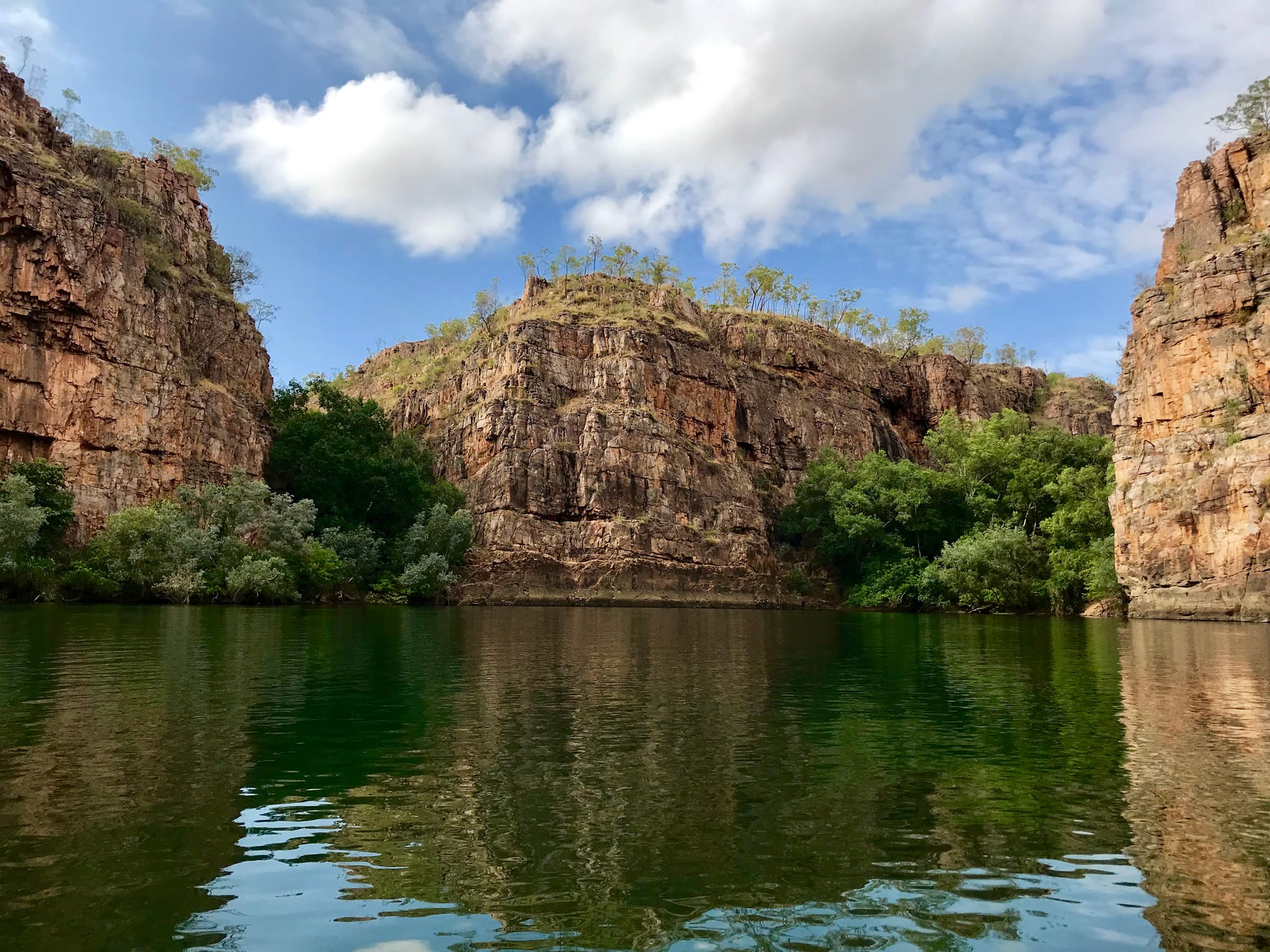
Sandstone gorge walls above a still green river, with low trees on the clifftops under a blue sky

The Northern Territory, Australia

Katherine

The Katherine River between sandstone walls in Nitmiluk National Park, north-east of the town. (Ovico / Wikimedia Commons · CC BY-SA 4.0)

The Northern Territory town where the Stuart Highway crosses the Katherine River, about 320 kilometres south of Darwin. Jawoyn, Dagoman and Wardaman country, it grew from a river crossing and a telegraph station into the service centre for a vast cattle and community region, and is the base for Nitmiluk, the gorge cut by the river to the north-east.

Neighbourhoods

  • The town centre and Katherine Terrace
    • First-time visitors
    • Close to shops
    • Pubs and cafés

    The Stuart Highway runs through the middle of town as Katherine Terrace, lined with the shops, pubs, bakeries, banks and motels that serve both the town and a region the size of a small country. Almost everything a traveller needs is on this one strip.

    Open in Maps
  • The riverside and the hot springs
    • Swimming
    • Picnics
    • Quiet and residential

    Below the centre the Katherine River runs through paperbarks and pandanus, with lawns, a walking path and a chain of warm spring-fed pools near the highway bridge. The low streets nearby have been flooded more than once, which is why much of the newer housing stands well back from the water.

    Open in Maps
  • Nitmiluk
    • Nature
    • Camping
    • Boats and canoes

    Thirty kilometres north-east by road, the national park whose custodians are the Jawoyn, for whom Nitmiluk means "place of the cicada dreaming". A visitor centre, campground and lodge sit at the mouth of the first gorge, where boat trips, canoes and walking tracks begin; beyond them there is nothing but river, sandstone and bush.

    Open in Maps
  • Katherine East and the Tindal road
    • Quiet and residential
    • Family stays

    The newer suburbs spread east and south of the centre towards the air force base at Tindal, about fifteen kilometres out. Most residents live here, in low houses on large blocks, among the hospital, the schools and the sports grounds.

    Open in Maps

Things to do

The gorge, the river and the falls

  • Nitmiluk National Parkpark

    Thirteen gorges cut by the Katherine River through sandstone, with rapids and falls between them, explored by flat-bottomed boat, canoe or walking track, on country of great ceremonial significance to its Jawoyn custodians.

    Open in Maps
  • Katherine Hot Springsattraction

    A chain of clear, warm pools fed by springs on the edge of the town centre, shaded by paperbarks and used for swimming through the dry season.

    Open in Maps
  • Leliyn (Edith Falls)attraction

    A tiered waterfall at the northern end of Nitmiluk National Park, dropping into a wide pool used for swimming, with a steeper walk up to smaller pools above it.

    Open in Maps
  • Jatbula Trailtrail

    A one-way walk of 62 kilometres from the gorge north to Leliyn, taken over five or six days in the dry season, following a route walked by generations of Jawoyn people and named after Peter Jatbula, who helped win their land rights.

    Open in Maps

Town sights and culture

  • Katherine Museummuseum

    The district's history at the old Katherine Airfield beside the former runway, where the aircraft flown by Clyde Fenton, the Territory's first flying doctor, is preserved in a purpose-built hangar.

    Open in Maps
  • Springvale Homesteadlandmark

    A stone homestead of 1879 on the river west of town, the oldest surviving cattle station homestead in the Territory, set among lawns and paperbarks.

    Open in Maps

Short trips from the town

  • Cutta Cutta Caves Nature Parkattraction

    Limestone caves about thirty kilometres south of the town, with formations, bats and ranger-guided tours, in a park of tropical woodland and karst.

    Open in Maps
  • Mataranka and Elsey National Parkpark

    The Mataranka thermal pools in palm forest, in a park that runs east of Mataranka about a hundred kilometres south, in the country of the Australian classic We of the Never Never.

    Open in Maps
  • Bitter Springsattraction

    A clear, warm spring-fed channel near Mataranka, drifted down slowly among palms and paperbarks rather than swum in.

    Open in Maps

Seasonal events

  • Barunga Festivaldry season

    A weekend of music, sport, art and Indigenous politics at the Jawoyn community of Barunga, east of the town, first held in 1985 and the place where the Barunga Statement calling for a treaty was presented to the prime minister in 1988.

  • Territory DayJuly

    The anniversary of Territory self-government on 1 July, the one evening of the year when Territorians may buy and set off their own fireworks.

  • Katherine Showdry season

    The district's agricultural show, run by the Katherine and District Show Society at the showgrounds, with cattle and horse events, sideshows and the region's growers and stations on display.

Eat and drink

Long-standing places and food districts in Katherine. Hours, ratings and directions come from your maps app, always current.

Eating in Katherine

  • Katherine Terraceneighborhood

    Most of the town's eating is along the highway strip — bakeries, pubs serving steak and barramundi, Thai, Chinese and Indian kitchens, and takeaway counters busy with travellers and station workers.

    Open in Maps
  • Katherine's dry-season marketsmarket

    Weekend markets through the cooler months, with fruit from the farms along the river, coffee and food stalls.

    Open in Maps
  • Nitmiluk Visitor Centrecafe

    The café at the gorge visitor centre, useful before or after a boat trip, with a terrace looking towards the escarpment.

    Open in Maps

Experience Katherine

History

Katherine grew at one of the few crossings of a river that runs all year, on the country of the Jawoyn, Dagoman and Wardaman peoples. John McDouall Stuart reached it in 1862 on his crossing of the continent and named the river after Catherine Chambers, a daughter of one of the men who paid for his expedition. The Overland Telegraph line came through a decade later, with a repeater station near the crossing, and a pub, a store and a police station followed on the riverbank.

Pastoralists took up the surrounding country in the 1870s and 1880s, and the frontier here, as across northern Australia, was violent. Springvale, built in 1879, survives as the Territory's oldest station homestead. The railway from Darwin reached the river in 1917, and the town moved to meet it.

The Second World War filled the north with troops. Airfields were built along the road south, which was sealed to carry military traffic, and on 22 March 1942 Japanese aircraft bombed Katherine — the furthest south any raid reached in the Territory. The airfield at Tindal, south-east of the town, dates from this period and became a permanent air force base in the 1980s.

The gorge and the country around it are Jawoyn land, and Nitmiluk National Park, established there, turned the town into a tourism destination. The river has repeatedly overwhelmed the town it created, in 1931, 1940, 1957 and worst of all on Australia Day 1998, when rain from Cyclone Les brought it to a record 20.4 metres, flooded the centre and affected 1,100 homes; parts of the town went under again in April 2006. Katherine has grown steadily as the region's service town.

Culture & Customs

Katherine is a meeting point. Jawoyn, Dagoman and Wardaman people belong to the town's own country, and residents and visitors come in from Aboriginal communities across a region reaching to Arnhem Land, the Roper River and the Victoria River district. Kriol, an English-based creole of the north, is heard in the street alongside Jawoyn and other languages.

Art from the surrounding communities reaches visitors through the town's galleries and the art centres of the region. The Barunga Festival, held in the dry season at the Jawoyn community of Barunga east of the town and first run in 1985, brings together music, sport and Indigenous politics; it was there in 1988 that the Barunga Statement, calling for a treaty, was presented to the prime minister, Bob Hawke.

The other half of the town's culture is pastoral. This is cattle country, and the Katherine Show fills the showground with stock, horses, woodchopping and sideshows, while campdrafts and rodeos run through the dry season. Country music has a strong following, work starts early and a broad hat is not a fashion statement.

The population turns over constantly: air force families at Tindal, nurses, teachers, police and park staff on postings of a few years, backpackers picking mangoes, and retired travellers in caravans who fill the parks every dry season. Alcohol restrictions and their effects are a constant subject of local argument, as they are across the Territory.

Daily Life

About 9,600 people live in Katherine, with several thousand more in the surrounding district, which makes it one of the largest towns in the Territory and the service centre for an area bigger than many countries. About a quarter of residents are Aboriginal, and the town's shops, hospital and offices are used by communities hundreds of kilometres away.

Work is in cattle and horticulture — mangoes, melons and hay grow on farms along the river — at the air force base, in road transport at the junction of two highways, in tourism through the dry season, and in health, education and government. The hospital and the regional offices make this the place people travel to for appointments, court, banking and a serious shop.

Housing runs from older raised houses near the river to newer estates in Katherine East. Heat sets the shape of the day: work and sport early, a quiet middle, life returning in the evening. The wet season empties the caravan parks, fills the river and keeps a town with two bad floods in living memory watching the gauge.

Long-running local concerns include the cost and supply of housing, alcohol policy, crime and services for young people, and water security for the town and its farms, which draw on the limestone aquifers beneath the plains.

Food

Katherine eats like a cattle town with tropical produce at hand. Beef from the surrounding stations and barramundi, from the rivers and from farms, are the staples of pub and club menus, usually grilled and served with chips and salad, and buffalo or crocodile appears now and then as a novelty.

The farms along the Katherine River grow mangoes, melons, pumpkins and hay. The Katherine region is one of Australia's main mango districts, and its early-season fruit, picked from about September, fills the town with mangoes, smoothies and pickers, and roadside stalls and weekend markets sell it alongside bananas, limes and pawpaw from smaller blocks.

The town's kitchens are more varied than its size suggests. Thai, Chinese, Indian and Filipino restaurants and takeaways are run by families who have settled here, and the weekend markets bring out food stalls through the dry season. Bakeries do steady trade in pies and sausage rolls for travellers heading out along the highways.

Bush foods belong to the district too. Kakadu plum, yams, fish and game are still gathered and hunted in season by people with the right to do so. The roadhouses spaced along the Stuart and Victoria highways, sometimes a hundred kilometres apart, keep drivers fed on burgers, chips and strong tea, and they are as much a part of eating in this region as anything in the town itself.

Planning tools

Budget

Katherine is a cheaper stop than Darwin for a room, but fuel and groceries cost more, and the town fills in the dry season with caravans, tour groups and travellers breaking the drive between Darwin and the centre. Boat trips and canoe hire at the gorge, park fees and a hire car are the main extras. Camping and the free swimming places keep costs low.

Daily Budget Midrange
USD 180–320 (motel room, pub and restaurant meals, a gorge cruise or canoe hire, a hire car)
Daily Budget Shoestring
USD 70–120 (campsite or hostel bed, self-catering from the supermarket, fuel shared between travellers)

Book gorge cruises, canoes and the long walk ahead in the dry season, and book a room early around the show and the school holidays; the hot springs, the riverside paths and the town's lookouts cost nothing.

Best Time to Visit

May to September is the season here: warm, clear days, cool nights, dry roads and low, clear water in the gorge. The multi-day walk and the four-wheel-drive tracks belong to these months too. From December to March the country is green and the falls are full, but the heat and humidity are heavy and high water can stop boat trips and cover the hot springs.

Suggested Number of Days

One or two days covers the town and the national park beside it. Three or four allow a longer walk, a paddle, the caves and the thermal springs to the south, or a proper pause on the drive between Darwin and the centre. Wet-season water levels limit both boating and walking.

First Visit
1–2 days
With Surroundings
3–4 days

Transportation

There is no useful public transport, and almost everyone drives. Taxis work in the town, and in the dry season tour operators and shuttles run out to the gorge, which is reached by a sealed road. The town sits at the junction of the Stuart and Victoria highways, so long-distance coaches call, and a four-wheel drive is needed for some park tracks and station roads.

Fill the fuel tank in town, because fuel is dearer and further apart along the highways, avoid driving at dawn, dusk and night when cattle and wildlife are on the road, and check conditions before leaving the bitumen in the wet season.

Airport & Station Connections

Katherine is about 320 kilometres south-east of Darwin on the Stuart Highway, three and a half to four hours by car, and the usual overnight stop on the long drive south to Alice Springs, roughly 1,180 kilometres further. The Victoria Highway runs west towards Kununurra and Western Australia. The Ghan train between Darwin and Adelaide stops here for a few hours, a small civil terminal at the air force base handles occasional flights and charters, and coaches use the highway.

Walkability

The centre is a flat strip of about a kilometre that is easily walked, with the river, the hot springs and the museum within reach of it on foot. Heat rather than distance is the limit, and most walking is done early or late in the day. The gorge, the caves and the residential suburbs all need a vehicle.

Safety

Freshwater crocodiles live in the Katherine River, and saltwater crocodiles move upstream in the wet season; park staff survey and remove them before the gorge boating season opens, and swimming is safe only where signs allow. The river floods: it reached a record 20.4 metres in January 1998 and inundated the town centre, and put parts of the town under water again in April 2006. Heat, long remote roads and dry-season bushfires are the other real risks. The town has higher rates of assault and property crime than southern Australia, much of it alcohol-related and concentrated late at night near the licensed venues.

Swim in the hot springs and the marked pools rather than the open river, carry water on every walk, and check road and river reports before driving out of town in the wet season. Check current official travel advice before travelling.

Climate

Tropical savanna, inland and hotter than the coast, with a dry season from about May to September and a wet season from December to March. The dry has warm days and genuinely cool nights; the wet is hot, humid and stormy, and the river can rise quickly. The hottest weeks come before the rain, when temperatures pass 40°C between late September and late November.

Summer
December to February is summer in the southern hemisphere and the wet season — hot and humid, with daily highs typically 30 to 37°C, monsoon storms and the risk of flooding
Winter
June to August is the dry season — clear warm days with genuinely cool nights, regularly dropping to about 7°C around June and July

Local Customs

The Jawoyn, Dagoman and Wardaman peoples are the traditional owners of the town's country, and Aboriginal languages and Kriol, an English-based creole, are heard in the street beside English. Manners are informal, first names are used at once, tipping is not expected and prices include the 10 per cent goods and services tax. Dress is practical, and a wide hat is normal.

Ask before photographing people or artwork, do not enter Aboriginal communities or homelands without a permit, and note that takeaway alcohol is restricted across the Territory, with identification checked when it is bought.

Common Payment Methods

The currency is the Australian dollar. Cards and contactless payment are accepted in the shops, pubs, motels and at the national park, and there are banks and cash machines in the centre. Cash is worth carrying for roadhouses, community stores and market stalls, where card connections can drop out.