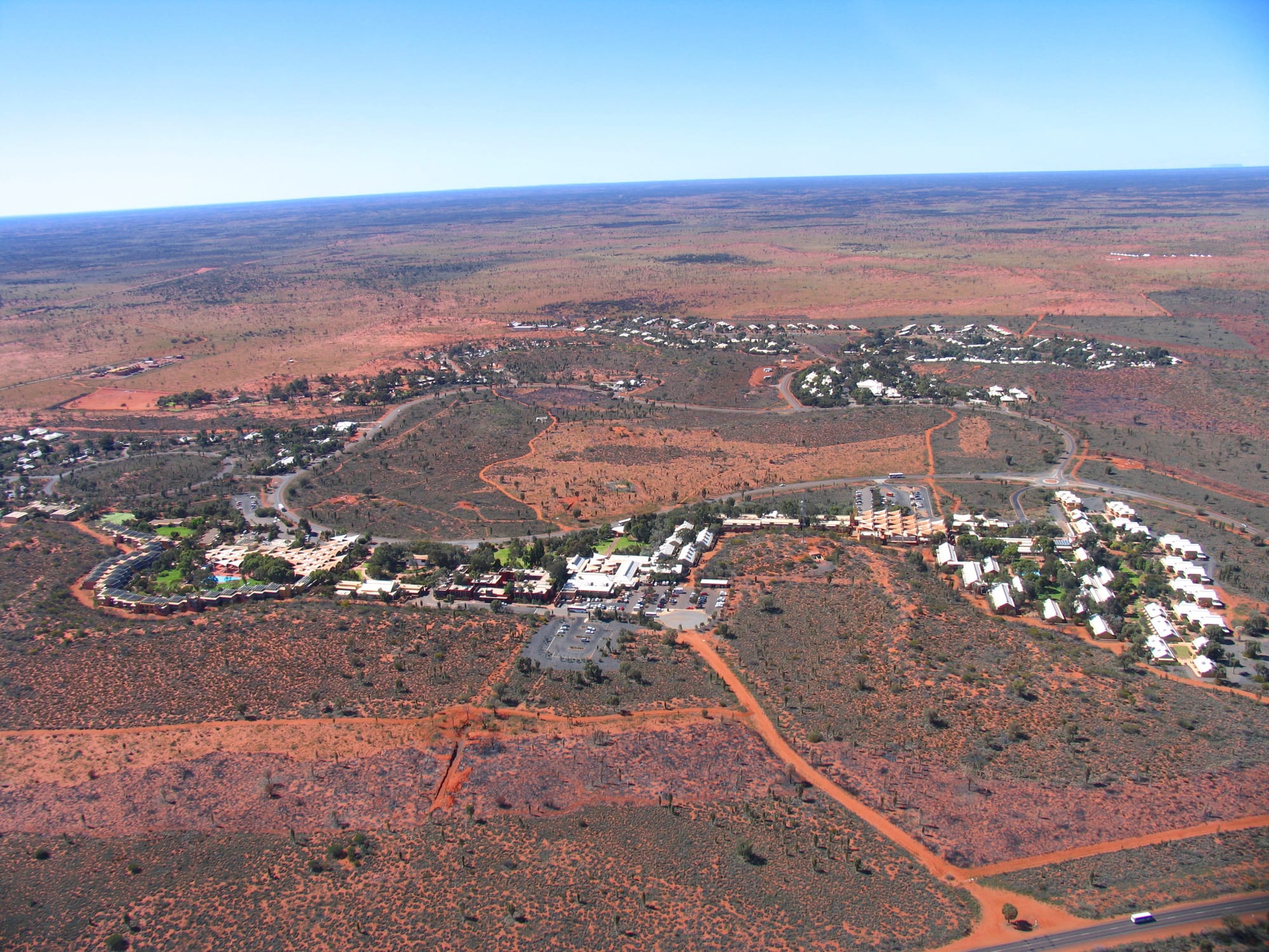
An aerial view of a small desert village of low buildings and curving roads spread through red sand and scrub

The Northern Territory, Australia

Yulara

Yulara, the resort village outside Uluru-Kata Tjuta National Park, seen from the air. (Menphrad at English Wikipedia / Wikimedia Commons · Public domain)

Yulara is a purpose-built village in the Northern Territory desert, about 18 kilometres from Uluru and just outside the national park boundary. Opened in 1984 to replace motels that once stood at the base of the rock, it holds almost all the accommodation, shops and tour offices for visitors to Uluru and Kata Tjuta, and houses the staff who run them.

Neighbourhoods

  • The Town Square
    • First-time visitors
    • Shops and food
    • Close to public transport

    The village centre, a ring of low buildings under shade sails holding the supermarket, post office, cafés, an art gallery, the tour and information desks and a lookout on the dune behind. The village shuttle stops here, and everything in Yulara is a few minutes away.

    Open in Maps
  • The hotels on the loop road
    • Comfort
    • Families
    • Sunset views

    The larger hotels sit around the single loop road that circles the village, screened from each other by dunes and desert oaks. Some rooms and terraces look out towards Uluru or Kata Tjuta, and the hotels hold the swimming pools, bars and dining rooms.

    Open in Maps
  • The campground and lodge end
    • Camping
    • Cheapest beds
    • Self-catering

    The budget end of the village, with a large campground and caravan park, powered sites, cabins and lodge rooms including dormitories. Shared camp kitchens and barbecues make this the cheapest way to eat and sleep at Uluru.

    Open in Maps

Things to do

Uluru-Kata Tjuta National Park

  • Ulurulandmark

    The sandstone monolith that rises about 348 metres from the plain, sacred to Aṉangu, ringed by a flat walking track past waterholes, caves and rock art.

    Open in Maps
  • Kata Tjutalandmark

    A group of steep-sided domes west of Uluru, higher than the rock itself, walked through on the Valley of the Winds circuit and the shorter Walpa Gorge track.

    Open in Maps
  • The Uluru base walktrail

    A level circuit of roughly ten kilometres around the foot of Uluru, the closest view of its caves, seams and paintings, and best done in the cool of early morning.

    Open in Maps
  • Uluru-Kata Tjuta Cultural Centremuseum

    The park's centre near the base of Uluru, where Aṉangu explain Tjukurpa, the law and stories of this country, alongside art centres run by local artists.

    Open in Maps

At Yulara and beyond

  • Field of Lightattraction

    Bruce Munro's installation of thousands of lit glass spheres spread across the sand near the village, first shown here in 2016 and seen after dark.

    Open in Maps
  • Maruku Artsattraction

    An Aṉangu-owned art enterprise selling paintings and punu, carved wooden objects, with a market stall in the Yulara town square and a gallery at the park's Cultural Centre.

    Open in Maps
  • The dune lookoutsviewpoint

    Short boardwalks climb the red dunes inside the village to viewing platforms that take in Uluru to the east and the domes of Kata Tjuta to the west.

    Open in Maps
  • Mount Connerlandmark

    A flat-topped mesa east of Yulara, visible from the highway and often mistaken for Uluru by drivers arriving from Alice Springs.

    Open in Maps

Seasonal events

  • The cool seasonMay to September

    The busiest months, when days are mild, nights are cold and the long walks are comfortable; flights and accommodation are at their fullest.

  • Summer heatDecember to February

    The hardest season, when temperatures often pass 40°C, rangers close the longer walks once the day heats up, and most sightseeing happens at dawn and dusk.

  • Green desert after rainirregular, most often in summer or early autumn

    Heavy rain is rare, but when storms fall the spinifex plains turn green, claypans fill and waterfalls run briefly down the sides of Uluru.

Eat and drink

Long-standing places and food districts in Yulara. Hours, ratings and directions come from your maps app, always current.

Eating at the resort

  • The Town Square's cafés and food outletsneighborhood

    Most casual eating happens around the village square, with cafés, a bakery counter, takeaway food and a bar, all within a short walk of each other.

    Open in Maps
  • Hotel dining roomsrestaurant

    The hotels hold the village's sit-down restaurants, from buffets to a small number of more formal rooms, several of which put native ingredients on the menu.

    Open in Maps
  • Dinner out in the dunesrestaurant

    Long-running outdoor dinners are held on cleared ground away from the village lights, with tables in the open, a buffet of native-influenced dishes and a talk about the night sky.

    Open in Maps

Self-catering

  • The village supermarketmarket

    The one grocery store in the village, stocked by truck from Alice Springs; the cheapest way to eat here, and the place campers and lodge guests shop.

    Open in Maps
  • Camp kitchens and barbecuesneighborhood

    Shared kitchens, sinks and gas barbecues at the campground and lodge, used heavily at sunset by campers and people driving the Red Centre.

    Open in Maps

Experience Yulara

History

Uluru and Kata Tjuta stand in the country of Aṉangu, the Pitjantjatjara and Yankunytjatjara people, who have lived across this part of the Western Desert for tens of thousands of years and whose law and stories, Tjukurpa, are tied to particular caves, waterholes and features of the rock. Europeans reached the area in the 1870s: Ernest Giles saw Kata Tjuta in 1872 and named it Mount Olga, and William Gosse reached the monolith the following year and named it Ayers Rock after Sir Henry Ayers, then the Chief Secretary of South Australia.

The land was part of an Aboriginal reserve before a section was excised from the Petermann Reserve in 1958 for a national park, and through the 1960s and 1970s motels, a campground, an airstrip and a shop grew up at the foot of Uluru itself, causing erosion and damage to a place its owners hold sacred. The answer was to move the visitors out. A new village was built beyond the park boundary, low and screened by dunes, and Yulara opened in 1984; the leases on the old motels at the base were ended and the site rehabilitated.

On 26 October 1985 the title to the park was handed back to its Aṉangu owners, who leased it back for 99 years to be run jointly, and in 1987 the park was inscribed on the World Heritage list for its natural and cultural landscape. In May 2017 a First Nations national constitutional convention met at Uluru and issued the Uluru Statement from the Heart. Climbing Uluru ended on 26 October 2019.

Culture & Customs

Yulara is unusual: a town with no history of its own, built in a few years to serve a place of great significance to other people. Almost everything a visitor does here is shaped by Aṉangu decisions about their country. Tjukurpa sets out what may be told to outsiders and what may not, which is why some cliffs and caves carry signs asking that they not be photographed, why guided walks explain some stories and stop short of others, and why the long-requested end to climbing the rock was eventually made law.

Aboriginal art is the strongest cultural presence in the village. Art centres and galleries sell paintings from Western Desert communities and punu, wooden objects carved and marked with a hot wire, and artists often work in view of visitors. Pitjantjatjara and Yankunytjatjara are living languages here, and palya, meaning good or fine, is the word most visitors pick up. The resort runs training and employment programmes intended to put more Indigenous staff into the hotels and tours.

The other culture is that of the workforce. Staff come from across Australia and overseas on seasonal contracts, live in housing rented from the resort, and create the sociable, transient atmosphere of a remote work camp: early shifts, shared houses, sport and barbecues in the cool of the evening, and a constant turnover of people.

Daily Life

About a thousand people live at Yulara, and nearly all of them work in tourism — in the hotels, the campground, the restaurants, the shops, the tour companies, the airport, the park, the school, the clinic and the police station. The village and its hotels are run as a single resort, sold in March 2026 by the Indigenous Land and Sea Corporation to the tourism company Journey Beyond, so one employer is responsible for most of the housing, services and jobs.

The day is organised around heat and light. Kitchen and housekeeping shifts start before dawn, tour buses leave for sunrise, the middle of the day is quiet and shaded, and the village comes out again in the late afternoon. Flights arrive and leave in a cluster, and the population of visitors turns over every few days.

Everything is freighted in from Alice Springs, about 430 kilometres away, which is also where residents go for a hospital, a hardware store or a wider choice of shops. Water comes from bores, solar panels supply part of the power, and waste and supplies travel long distances. Staff turnover, the cost of living and the shortage of housing are the standing local problems. A few kilometres away inside the park lies Mutitjulu, the Aṉangu community at the base of Uluru, which is a residential place rather than a stop for visitors.

Food

Food at Yulara is resort food, and there is no competing town to keep prices down. The Town Square holds cafés, takeaway counters and a bar for casual meals, and the hotels have the sit-down restaurants, ranging from buffets to a few more formal rooms. Several menus lean on native ingredients: kangaroo and barramundi, quandong and desert lime, wattleseed, lemon myrtle and the small sharp bush tomato known as kutjera.

The most distinctive way to eat here is outdoors. Long-running dinners are held on cleared ground away from the village lights, with tables under the open sky, a buffet of native-influenced dishes and someone to point out the southern constellations once the meal is over. Inside the park itself there is only a small café at the cultural centre, so most people carry water and food with them.

For anyone watching costs, the village supermarket is the answer, and the camp kitchens and barbecues at the campground are busy every evening. Aṉangu bush foods from this country include the witchetty grub, bush tomato and ground seed cakes, and tours led by Aṉangu guides explain how they are found and prepared, which is a different thing from finding them on a menu.

Planning tools

Budget

Yulara is one of the most expensive places to stay in Australia. There is one operator, no competing town nearby, and everything is flown or trucked in, so room rates, meals and groceries all carry a premium. A national park pass, valid for several days, is needed as well. Camping, the lodge dormitories and cooking for oneself cut the cost dramatically, and many visitors come on a package or a camping tour from Alice Springs instead.

Daily Budget Midrange
USD 230–400 (hotel room, meals out, park pass, a guided walk or sunset tour, a hire car)
Daily Budget Shoestring
USD 90–150 (campsite or dormitory bed, food from the supermarket, the village shuttle, park pass)

Book rooms, flights and tours months ahead for the cool season, buy the park pass before arriving, and carry food in from Alice Springs if the budget is tight.

Best Time to Visit

May to September, when days are warm rather than dangerous and the nights are cold and clear. April and October are hotter but quieter. From December to February the heat is extreme, walks are cut short or closed during the day, and flies are at their worst, though prices soften and storms can bring a brief green flush to the desert.

Suggested Number of Days

Two or three days suit most visitors, allowing for early starts and for the light at each end of the day. Four or five take in a wider loop through the Red Centre. Heat shortens what fits into a day, so a summer visit needs longer to cover the same ground.

First Visit
2–3 days
With Surroundings
4–5 days

Transportation

A shuttle bus loops the village between the hotels, campground and Town Square. The national park begins several kilometres away, so reaching Uluru or Kata Tjuta means a hire car, a shuttle service or a guided tour; coaches and minibuses run to the sunrise and sunset viewing areas. Hire cars and campervans are available at the airport, and bicycles can be hired in the village. Roads within the park are sealed.

Fuel is sold in the village and nowhere nearby, so fill up before long drives; avoid driving at dawn, dusk and night, when camels, dingoes and kangaroos are on the road.

Airport & Station Connections

Ayers Rock Airport, also called Connellan, is about six kilometres north of Yulara and has direct flights from several Australian cities and from Alice Springs; hotel shuttles meet arrivals. By road, Yulara is about 430 kilometres from Alice Springs, four to five hours on the Stuart Highway and then the Lasseter Highway, which is sealed all the way. Coach services and multi-day camping tours also run from Alice Springs.

Walkability

The village is small, flat and designed to be walked, with paths and boardwalks linking the hotels, the campground and the Town Square, and a shuttle for anyone who would rather not walk in the heat. Nothing beyond the village is walkable: Uluru is about 18 kilometres away and the highway has no footpath, so the park always needs wheels.

Safety

Yulara is a safe, managed village and the risks here are the desert's. Heat and dehydration are the serious ones, and people have died walking in summer without enough water. Sunburn, flies in the warmer months, cold nights, and dingoes that should not be fed or approached are the rest. Walks in the park are closed by rangers in extreme heat, and there is no natural water to swim in anywhere nearby.

Carry at least a litre of water an hour for any walk, start at first light, wear a hat and a fly net in the warmer months, and turn back rather than finish a walk in the heat of the day. Check current official travel advice before travelling.

Climate

Hot desert climate, with very hot summers, mild sunny winter days and cold winter nights. In the southern hemisphere summer falls in December to February and winter in June to August. Rainfall is low and irregular and arrives mostly in summer storms; the sky is clear most of the year.

Summer
very hot and dry — days commonly 35–38°C and often above 40°C, with warm nights and many flies
Winter
mild and bright by day, cold at night — days around 20–23°C, with cold nights

Local Customs

This is Aṉangu country, held by Pitjantjatjara and Yankunytjatjara traditional owners and managed jointly with the national parks service. Tjukurpa, the law and knowledge carried in this landscape, governs what may be shown and told, and some places are signposted as not to be photographed. Climbing Uluru has been prohibited since October 2019, at the long-standing request of its owners. Tipping is not expected in Australia, and greetings are informal.

Stay on marked tracks, obey signs asking that particular sites not be photographed, take no rocks, sand or plants, and ask before photographing people. Alcohol is sold at the resort, but surrounding Aboriginal land is subject to restrictions and it should not be taken into communities.

Common Payment Methods

The currency is the Australian dollar. Cards and contactless payment are taken throughout the village, at the airport and by tour operators, and there are cash machines at the Town Square. Prices are noticeably higher than in the cities because of freight. Mobile coverage works in the village and along parts of the park road, but not everywhere.