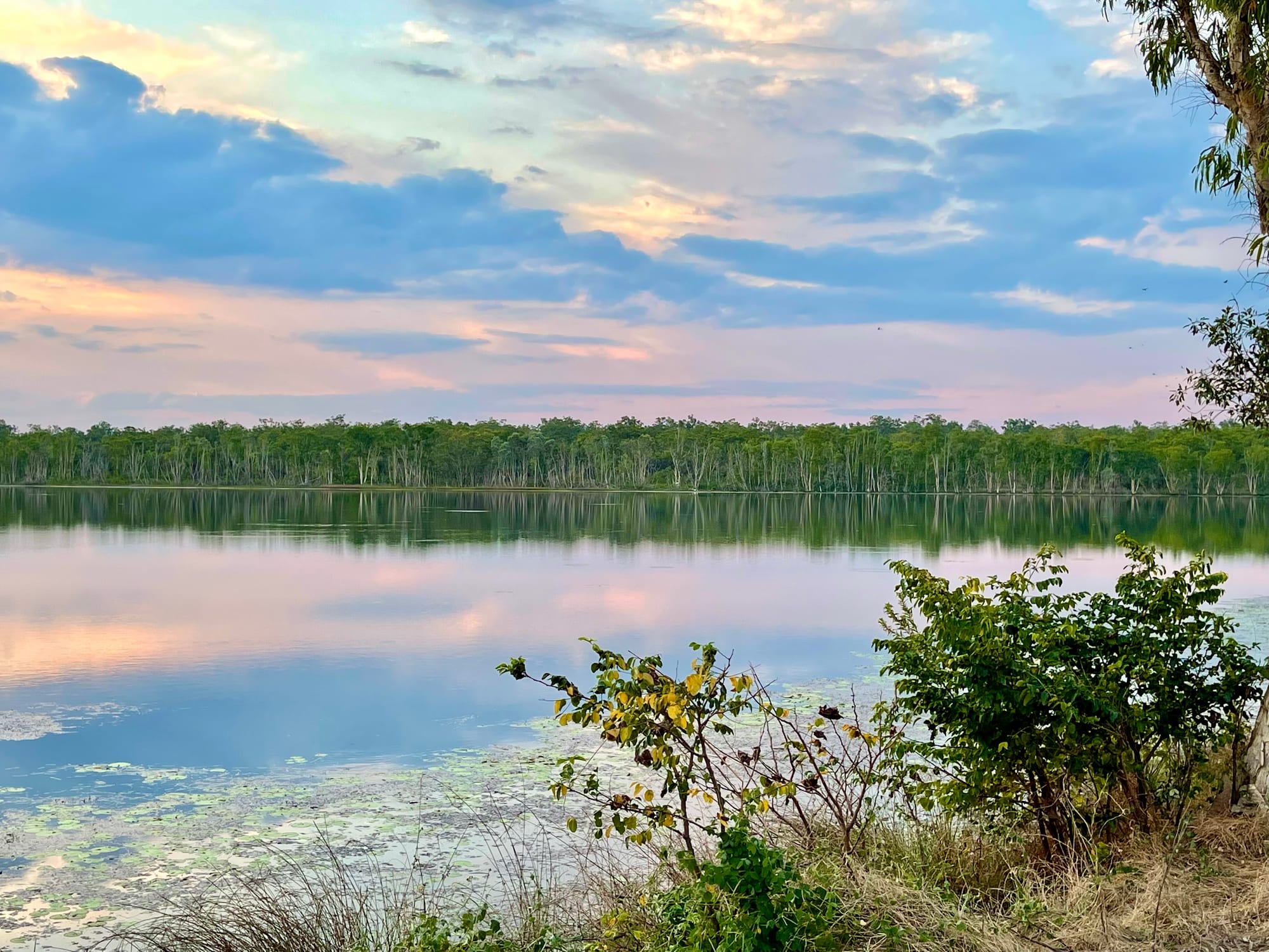
A still lake at sunset reflecting pink cloud, ringed by pale-trunked trees with water lilies in the shallows

The Northern Territory, Australia

Jabiru

Jabiru Town Lake at dusk, in the town inside Kakadu National Park. (Kgbo / Wikimedia Commons · CC BY-SA 4.0)

A planned town of about a thousand people inside Kakadu National Park, built in the early 1980s to house workers at the Ranger uranium mine on Mirarr land. With the mine closed and the town's lease now held by its Aboriginal traditional owners, Jabiru is remaking itself as the service centre for Kakadu's rock art, wetlands and waterfalls.

Neighbourhoods

  • Jabiru town centre
    • First-time visitors
    • Close to shops
    • Family stays

    The whole town is a few loops of low, louvred houses around an artificial lake. A small plaza with a supermarket, a bakery and a service station sits at the middle, with the hotels, the pool, the school and the sports oval a short walk away, and the Aboriginal-owned art centre nearby.

    Open in Maps
  • Bowali and the park entrance
    • Park information
    • Arriving

    Just outside the town on the Kakadu Highway stands the national park's headquarters and main visitor centre, a low building designed by the architect Glenn Murcutt. Exhibitions explain the park's country, seasons and joint management, and there is a shop and a café. Most visitors stop here first.

    Open in Maps
  • East Alligator and Ubirr
    • Rock art
    • Sunset views
    • Camping

    About forty kilometres north-east, where the East Alligator River marks the boundary of Arnhem Land. The Ubirr rock-art galleries and the lookout above them are here, along with a campground, a riverside walk and the causeway at Cahills Crossing, where saltwater crocodiles gather to feed on fish.

    Open in Maps
  • Cooinda and Yellow Water
    • Wildlife cruises
    • Camping
    • Best for food

    Fifty kilometres south along the Kakadu Highway, Gagudju Lodge Cooinda, a campground and an airstrip stand beside the wetland known as Yellow Water, where flat-bottomed boats go out among lilies, crocodiles and waterbirds. The Warradjan cultural centre is close by, and this is the other place in the park to buy a meal.

    Open in Maps

Things to do

Rock art and culture

  • Ubirrlandmark

    Painted rock shelters at the edge of the Arnhem Land escarpment, with long panels of fish, animals and spirit figures, and a lookout above them over the Nadab floodplain.

    Open in Maps
  • Burrungkuy (Nourlangie)landmark

    A sandstone outlier some twenty kilometres south of the town, with the painted Anbangbang shelter, a short circuit walk beneath the rock and a lookout towards the escarpment wall.

    Open in Maps
  • Warradjan Aboriginal Cultural Centremuseum

    Near Cooinda, the park's Aboriginal cultural centre, explaining Bininj law, kinship, seasons and bush food in the words of local people.

    Open in Maps

Wetlands and wildlife

  • Kakadu National Parkpark

    The park that surrounds the town, nearly 20,000 square kilometres of escarpment, floodplain, monsoon forest and tidal river, listed by UNESCO for both its natural and its cultural values.

    Open in Maps
  • Yellow Waterattraction

    The park's best-known wetland, on the South Alligator floodplain near Cooinda, crossed by boat among water lilies, saltwater crocodiles, sea eagles and magpie geese.

    Open in Maps
  • Mamukala Wetlandsattraction

    A floodplain west of the town with a short walk and a screened bird hide, where magpie geese gather in large numbers as the floodplain dries back late in the dry season.

    Open in Maps
  • Cahills Crossingattraction

    The tidal causeway over the East Alligator River into Arnhem Land, with a viewing area on the Kakadu bank for the saltwater crocodiles that gather there to feed on mullet and barramundi.

    Open in Maps

Waterfalls, gorges and lookouts

  • Jim Jim Fallsattraction

    A single drop of between 140 and 200 metres over the Arnhem Land escarpment into a plunge pool, reached in the dry season by a long gravel road whose last stretch needs a four-wheel drive, and by a rock scramble on foot; the flow falls away as the dry season goes on.

    Open in Maps
  • Twin Fallsattraction

    A pair of falls over the escarpment near Jim Jim, reached by a four-wheel-drive track some sixty kilometres from the Kakadu Highway.

    Open in Maps

In and around the town

  • Bowali Visitor Centreattraction

    The park's Glenn Murcutt-designed information centre a couple of kilometres from the town, with exhibitions on Kakadu's landscapes and seasons, park staff to ask about road and track conditions, a shop and a café.

    Open in Maps
  • Jabiru Town Lakepark

    The artificial lake at the centre of the town, circled by a path and busy with birds at dawn and dusk, though crocodiles mean there is no swimming.

    Open in Maps

Seasonal events

  • Kurrung, the end of the drymid-August to mid-October

    The hot, dry weeks of the Bininj season of Kurrung, when the billabongs shrink, birds crowd onto what water is left, and the four-wheel-drive tracks to the waterfalls are at their most reliable.

  • Kudjewk, the monsoonJanuary to March

    The monsoon season, with thunderstorms, heavy rain and flooding that can cut both the Arnhem and Kakadu highways, the escarpment waterfalls at full force and very few visitors in the park.

Eat and drink

Long-standing places and food districts in Jabiru. Hours, ratings and directions come from your maps app, always current.

Eating in Jabiru and the park

  • Jabiru town plazaneighborhood

    The town's small shopping centre, with a supermarket, a bakery and takeaway counters — the main place to buy food in this part of the park and where campers stock up before heading out.

    Open in Maps
  • Gagudju Crocodile Hotelrestaurant

    The hotel in the middle of the town, built in the shape of a crocodile, and one of the few places in Jabiru to sit down to a cooked meal.

    Open in Maps
  • Cooindaneighborhood

    Gagudju Lodge Cooinda, beside Yellow Water fifty kilometres south, is the usual stop for a cooked meal in this part of the park, with barramundi the standard order.

    Open in Maps

Experience Jabiru

History

Jabiru lies in the country of the Mirarr, an Aboriginal clan group of western Arnhem Land, and rock shelters in the surrounding escarpment hold some of the oldest evidence of human occupation in Australia. The town itself is recent. Uranium was found at Ranger, a few kilometres away, in late 1969, and the Ranger Uranium Environmental Inquiry of the 1970s, known as the Fox inquiry, recommended that mining begin at the site and that a service town be built. Kakadu was proclaimed in stages between 1979 and 1991; much of it is Aboriginal land, granted under Territory land-rights law and leased back to the Commonwealth to be run jointly with its traditional owners.

The town was laid out in the early 1980s to house Ranger's workforce and the park's staff, built around an artificial lake and named after the tall black-necked stork that Australians call the jabiru. For years only people working for the mine or the park could live there.

The Mirarr never agreed to mining. Their opposition became national news in 1998, when a blockade and an international campaign against a second mine at Jabiluka, led by the senior traditional owner Yvonne Margarula, stopped that project; surface works and a decline were built, but no mine.

Mining at Ranger finished in late 2012 and the plant processed stockpiled ore until January 2021, leaving a long rehabilitation of the site, for which the company holds access until January 2026. On 16 June 2021 the town was formally handed over to the Mirarr, and Jabiru is being rebuilt as a tourism and service town under Aboriginal ownership.

Culture & Customs

The Aboriginal people of Kakadu call themselves Bininj in the north of the park and Mungguy in the south, and several languages belong to the area, among them Kundjeyhmi, Kunwinjku and Jawoyn. English is the working language of the town. Aboriginal residents come from Jabiru itself, from outstations within the park and from Gunbalanya, across the East Alligator River in Arnhem Land.

Rock art is the region's great inheritance. The painted shelters near the town show fish, turtles and hunters, ancestral beings including the Rainbow Serpent, thin Mimih spirits, and, from the last two centuries, sailing ships and men with rifles. Some panels were repainted over thousands of years; others are closed to visitors as dangerous or sacred. Rangers and Bininj guides ask that people stay on the marked paths, touch nothing and carry no stone or plant away.

The local calendar has six seasons rather than two, running from the monsoon of Kudjewk through the cold, dry weeks of Wurrkeng to the hot weather of Kurrung, when the billabongs shrink and the storms build again. Each is read from what is flowering, what is fat and worth hunting, and when country should be burned; the smoke of deliberate burning is part of the dry-season air.

Kakadu is a working cultural landscape rather than a museum. Fire is still used to clean country, and the park's controlled burning is done in consultation with the traditional owners who have managed the land with it for thousands of years. Aboriginal art and culture are among the town's main industries alongside tourism, and the hotel built in the shape of a crocodile shows how closely the region is identified with the animal.

Daily Life

Roughly a thousand people live in Jabiru, a number that fell when the mine closed and that rises through the dry season with tour guides, contractors and seasonal park staff. About a quarter of residents are Aboriginal, and the town is also home to rangers, teachers, nurses, police and shopkeepers, many of them on postings of a few years.

The houses are low, louvred and raised, set in loops around the lake, and the public buildings — school, clinic, police station, pool, oval and shopping plaza — are all within walking distance. Work is in the national park and tourism, in the long rehabilitation of the Ranger site, and in schools, health services and local administration.

The year divides in two. From May to September the town is busy and the accommodation full; from December to March the visitors disappear, tracks close, the air grows heavy and the escarpment waterfalls come alive. Freight and groceries come up the highway from Darwin, three hours away, and prices reflect the distance; a specialist appointment or a big shop means the same drive.

The town's future is the main local subject: the shift from mining to tourism, the rebuilding of houses and public buildings under the Mirarr lease, and the question of what work will sustain a town of this size inside a national park.

Food

Eating in Jabiru is a small-town affair. The supermarket in the plaza, a bakery, a service station and the bistros at the town's hotels cover most meals, and the lodge at Cooinda, about an hour's drive south-west, is the other place in this part of the park to buy a cooked dinner. Barramundi is the fish of the region, grilled or crumbed, and buffalo and crocodile turn up on menus as local curiosities.

The deeper food tradition is Bininj: the fish, turtles, waterbirds, yams and lily stems of the floodplain, hunted and gathered in season by people with the right to do so, guided by the same six-season calendar that governs burning and fishing. The Kakadu plum, a small green fruit very high in vitamin C, grows in the woodland around the town and is now harvested commercially by Aboriginal enterprises.

Mangoes come in before the build-up, and the wet season thins supplies when the highway is cut. Campers generally cook for themselves or bring food from Darwin, and the town's art centre and bakery are the places for coffee and cake. Alcohol is sold in limited quantities and in limited places across the park, and some nearby communities are dry by law.

Planning tools

Budget

Costs here are those of a remote town. There is little competition on accommodation, fuel and groceries are dearer than in Darwin, and a Kakadu park pass, a wetland cruise or a guided four-wheel-drive trip are the usual extras. Camping in the park's own campgrounds is much cheaper than a room, and rates fall steeply in the wet season, when many services close.

Daily Budget Midrange
USD 200–350 (hotel or lodge room, restaurant meals, the park pass, a boat cruise and a hire car)
Daily Budget Shoestring
USD 80–130 (campground or budget room, self-catering from the supermarket, fuel shared between travellers)

Buy the Kakadu park pass before arriving, fill the fuel tank in the town rather than counting on remote pumps, and carry more drinking water than seems necessary.

Best Time to Visit

June to August is the most comfortable and the most open, with dry roads, four-wheel-drive tracks to the falls usually passable from about May or June, and birds concentrating on the drying billabongs from September. The wet season, roughly December to March, fills the waterfalls and greens the country, but closes many roads and leaves scenic flights as the way to see the escarpment.

Suggested Number of Days

Two or three days covers the sites within reach of the town on sealed roads. Four or five allow the tracks that need a four-wheel drive, a boat trip on the wetlands and time to wait for good light on the rock art. The wet season shortens what is possible.

First Visit
2–3 days
With Surroundings
4–5 days

Transportation

There is no public transport, in the town or in the park. Nearly everyone arrives by hire car, campervan or organised tour. Sealed roads reach the town, the main rock-art sites and Cooinda, so a normal car is enough for much of Kakadu, but a high-clearance four-wheel drive is required for the tracks to the waterfalls and some southern sites. Fuel is sold in the town and at Cooinda, and the airstrip is used for charter and scenic flights.

Check road and track conditions with park staff before setting out, avoid driving at dawn, dusk and night when buffalo, pigs and wallabies are on the road, and never drive into water of unknown depth.

Airport & Station Connections

Jabiru is about 250 kilometres east of Darwin by the Arnhem Highway, roughly a three-hour drive, and most visitors come that way by hire car or on a coach tour. The Kakadu Highway continues south-west through the park towards Pine Creek, the Stuart Highway and Katherine, the southern leg of the loop drive between Darwin, Kakadu and Katherine. A park pass is needed to enter Kakadu, and the town airstrip takes light aircraft rather than scheduled flights.

Walkability

The town itself is small enough to cross on foot in a quarter of an hour, and the path around the lake is a pleasant early-morning walk. Everything else needs a vehicle: the nearest rock art is half an hour away and the waterfalls much further. The walks at the sites themselves are short but exposed, with little shade and loose rock underfoot.

Safety

Saltwater and freshwater crocodiles live in the rivers, billabongs and even the town lake, and swimming is safe only in the plunge pools that park signs allow and in the hotel pools. Heat and dehydration are the other constant risk, with dry-season days often above 32°C and wet-season humidity higher still. Roads are long, remote and unlit, mobile coverage is patchy outside the town, and creek crossings flood quickly in the wet. Controlled burning fills the air with smoke in the cooler months.

Swim only where signs say it is permitted, carry several litres of water per person on any walk, leave word of the route before driving remote tracks, and keep well back from the water's edge everywhere. Check current official travel advice before travelling.

Climate

Tropical savanna, hotter than the coast because the town lies inland. The dry season runs from about May to September and the wet from about January to March, with a hot, stormy build-up between and about 1,565 millimetres of rain a year. Bininj people divide the same year into six seasons, marked by wind, flowering and the state of the floodplain.

Summer
December to February is summer in the southern hemisphere and the wet season — hot and very humid, with average maximums around 33°C in January, monsoon rain, thunderstorms and flooded roads
Winter
June to August is the dry season — warm, clear days averaging about 32°C, cool nights and almost no rain

Local Customs

This is Aboriginal land, leased back and jointly managed as a national park, and the courtesies matter. Visitors are asked to stay on marked tracks, take nothing away, and keep out of areas closed for cultural or safety reasons. Manners are informal, tipping is not expected and prices include the 10 per cent goods and services tax.

Ask before photographing people, art sites or ceremonies, do not touch rock paintings or the rock around them, and remember that a permit is needed to enter Arnhem Land across the river. Alcohol is restricted across the park and in nearby communities, and identification is checked when it is bought.

Common Payment Methods

The currency is the Australian dollar. Cards and contactless payment work at the supermarket, the service station, the hotels and the park's own counters, and the town plaza holds the shops, offices and services. Cash is worth carrying for small amounts and roadside stops, because there are no machines once the town is behind.