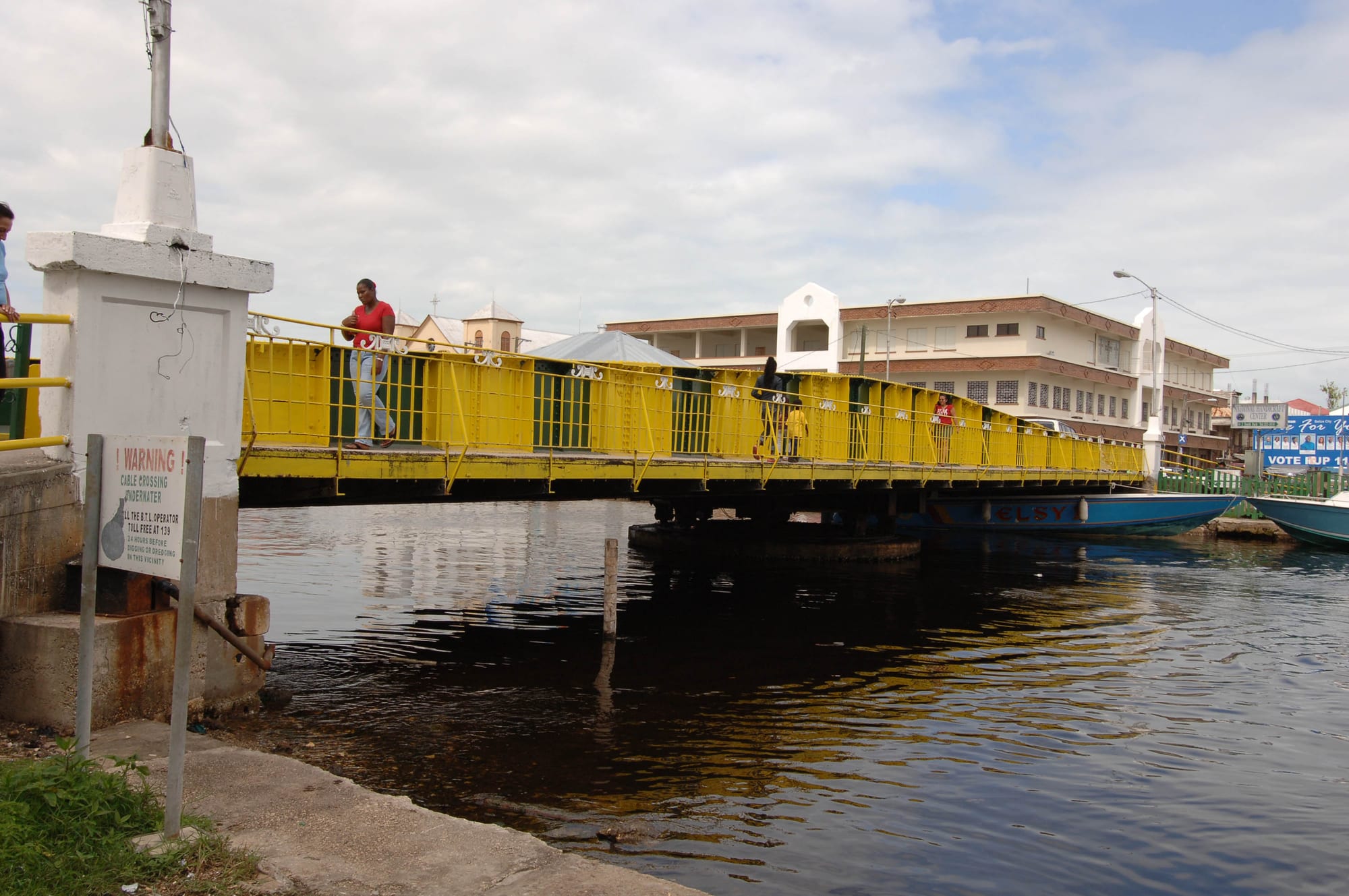
A yellow-railed steel swing bridge crossing a dark creek, with boats moored alongside and colonial-style buildings behind

Belize City, the Cayes & the North, Belize

Belize City

The Swing Bridge over Haulover Creek in downtown Belize City. (JERRYE AND ROY KLOTZ MD / Wikimedia Commons · CC BY-SA 3.0)

The largest city in Belize, built where Haulover Creek meets the Caribbean, began as the logwood and mahogany town of the Baymen and served as the colony's capital until 1970. Twice wrecked by hurricanes, it remains the country's main port and commercial centre — a low-lying Creole city of canals, clapboard houses and colonial landmarks, and the gateway to the cayes.

Neighbourhoods

  • Fort George
    • First-time visitors
    • Historic district
    • Close to the water taxis

    The most colonial part of the city, on the Northside point where Haulover Creek meets the sea. Memorial Park, the grave and lighthouse of Baron Bliss, the Museum of Belize and the cruise passengers' Tourism Village are here, along a seafront boardwalk, and the water-taxi terminals are a short walk away.

    Open in Maps
  • Downtown and Albert Street
    • Shopping
    • Historic buildings
    • Local life

    South of the Swing Bridge, Albert and Regent Streets form the commercial district, with shops and small shopping centres. St John's Cathedral and the old Government House stand at the southern end of Albert Street.

    Open in Maps
  • Northside suburbs
    • Quiet and residential
    • Close to the airport road

    West of Fort George, the Northside spreads into quieter residential areas such as Buttonwood Bay, Kings Park and University Heights; West Landivar nearby holds two of the University of Belize's city campuses.

    Open in Maps

Things to do

Famous landmarks

  • Swing Bridgelandmark

    A bridge built in Liverpool and installed over Haulover Creek in 1923, the oldest swing bridge in Central America and one of the few manually operated swing bridges in the world still in use; since 2007 it has been opened only on special request.

    Open in Maps
  • St John's Cathedrallandmark

    The oldest Anglican church in Central America, built by enslaved labour between 1812 and 1820 from bricks brought as ships' ballast, with a mahogany and sapodilla interior; Miskito kings were crowned here.

    Open in Maps
  • Government Housemuseum

    The governor's residence from 1814, now the House of Culture museum, with colonial glassware, silverware, furniture and archive records.

    Open in Maps
  • Yarborough Cemeterylandmark

    The country's oldest cemetery, beside St John's Cathedral, in use from 1787 to 1896.

    Open in Maps

Museums and the arts

  • Museum of Belizemuseum

    The national museum, in the city's colonial prison of the 1850s, which held prisoners until 1993; exhibits cover slavery and maroon communities, some 3,000 years of Maya history, colonial life and the prison itself.

    Open in Maps
  • Bliss Institutemuseum

    A modernist arts centre of the 1950s, almost entirely refurbished in 2003 as the Bliss Centre for the Performing Arts, now the largest cultural centre in Belize, with a theatre, the National Art Collection and finds from the Maya site of Caracol.

    Open in Maps
  • Image Factory Art Foundationmuseum

    An independent gallery and cultural centre on North Front Street with changing exhibitions of contemporary Belizean art.

    Open in Maps

Short trips from the city

  • Altun Halandmark

    The ruins of a Maya trading city about 31 miles north of Belize City, rediscovered by archaeologists in 1963; its Temple of the Masonry Altars appears on the label of Belikin beer.

    Open in Maps
  • Belize Zoopark

    A zoo about 29 miles west of the city, founded in 1983, where more than 175 animals of species native to Belize live in natural forest crossed by gravel trails.

    Open in Maps
  • Community Baboon Sanctuarypark

    A community-managed reserve founded in 1985 along the Belize River, where landowners in seven villages protect black howler monkeys, known locally as 'baboons'.

    Open in Maps
  • Crooked Tree Wildlife Sanctuarypark

    A protected wetland around the old Creole village of Crooked Tree, set up for the thousands of waterbirds that migrate to and through it every year.

    Open in Maps
  • Caye Caulkerattraction

    The car-free island about 20 miles north-north-east of the city, a shorter water-taxi ride than Ambergris Caye.

    Open in Maps

Seasonal events

  • National Heroes and Benefactors Day (Baron Bliss Day)March

    The public holiday first declared as Baron Bliss Day for 9 March and now kept on the nearest Monday, honouring the benefactor whose trust paid for the Bliss Institute and whose tomb is at Fort George; a regatta is held every year on the day.

  • September CelebrationsSeptember

    The weeks from St George's Caye Day on 10 September to Independence Day on 21 September, with the carnival among the events in the city.

  • Belize City CarnivalSeptember

    The city's carnival, held over several days in September; its main event, the Carnival Road March, is usually on the Saturday before 10 September.

  • Garifuna Settlement DayNovember

    The public holiday on 19 November celebrating the settlement of the Garifuna people in Belize; the main festivities are in Dangriga, and the day is also marked in the city.

Eat and drink

Long-standing places and food districts in Belize City. Hours, ratings and directions come from your maps app, always current.

Belize City classics

  • Creole breakfast placesrestaurant

    Small family-run places, including one within walking distance of the water-taxi terminal, serve hot breakfasts; the common Belizean breakfast is fry jacks or johnny cakes with beans and eggs.

    Open in Maps
  • Meat-pie shopsrestaurant

    Meat pies have small shops of their own in the city.

    Open in Maps

Food districts and markets

  • Albert Streetneighborhood

    The main street of the commercial district, lined with shops and small shopping centres, with simple restaurants among them.

    Open in Maps
  • Fort George seafrontneighborhood

    A ceviche place stands by the Bliss lighthouse, and the shops and restaurants of the Tourism Village open when a cruise ship is in port.

    Open in Maps

Experience Belize City

History

Belize City grew from a small Maya settlement called Holzuz at the mouth of Haulover Creek. English woodcutters founded Belize Town there in the 17th century, and the site suited them well: it lay on the sea at the natural outlet of the rivers and creeks down which logwood and later mahogany were floated for shipment. Thousands of enslaved Africans were brought in to work in the forests, and the town became their home as well as the Baymen's. The defence against the Spanish at the Battle of St George's Caye in 1798 was coordinated from here.

As the seat of the courts and the colonial government, the town was so dominant that historians say "the capital was the colony". Its street names still carry that past — Orange Street was named after the Protestant Orange Order. St John's Cathedral was built between 1812 and 1820 and the governor's residence from 1814, and in 1923 the Swing Bridge, made in Liverpool, replaced the wooden bridges over Haulover Creek. The city was the centre of the 20th-century labour and independence movements, even when their leaders tried to take them beyond it.

Disasters have repeatedly reshaped it. A hurricane in 1931 devastated the city, and Hurricane Hattie almost entirely destroyed it in October 1961, which led the government to move to the new inland capital of Belmopan in 1970. Large fires burnt out stretches of housing in 1999 and 2004, and Hurricane Richard in 2010 and Hurricane Earl in 2016 caused heavy damage. The city nonetheless remains the country's main port and its commercial heart.

Culture & Customs

Belize City is a centre of the Creole community, and Kriol is widely spoken. Its culture is often compared with that of Caribbean capitals such as St George's in Grenada or Georgetown in Guyana. Creole music includes brukdown, played on guitar, banjo, accordion and percussion that can include a donkey's jawbone.

The year's high point is September, from St George's Caye Day on 10 September to Independence Day on 21 September, with a carnival whose road march is usually held on the Saturday before 10 September. Baron Bliss Day in March, now National Heroes and Benefactors Day, honours the benefactor whose trust built the Bliss Institute, and Garifuna Settlement Day on 19 November is also celebrated. The city is the country's cultural centre: the Bliss Centre for the Performing Arts, which holds the National Art Collection, the Museum of Belize, the Maritime Museum, the House of Culture and independent galleries such as the Image Factory, as well as an annual street art festival.

Churches, among them the Anglican cathedral of St John's, remain part of community life. Most children in the city go on to high school, and the Northside's St John's College for boys and St Catherine's Academy and Pallotti High School for girls are its only single-sex schools.

Daily Life

Belize City had 63,999 people at the 2022 census, the largest population of any city in the country. Haulover Creek divides it into the Northside, which runs east to the Fort George area, and the Southside, which takes in downtown, the port and most of the city's outskirts. Three canals — Haulover Creek, Burdon Canal and Collet Canal — run through the Southside, where neighbourhoods such as Lake Independence, Collet and Port Loyola are home to some of the city's poorest residents, and rickety wooden walkways known as "London bridges" link some houses. The Northside includes quieter suburbs such as Buttonwood Bay and Kings Park.

The city is the country's principal port and its financial and industrial hub. All the major banks, the Central Bank, nearly all insurance companies and the Supreme Court are here, and it is the hub for air, sea and road travel. Many residents work in downtown offices; many others trade from stalls and the roadside. Cruise passengers come ashore at Fort George, where the Tourism Village opens when a ship is in port.

The city is governed by a mayor and ten councillors, elected every three years. It has more schools at every level than any other city in Belize. Flooding in the rainy season, poverty and gang violence in parts of the Southside are persistent problems.

Food

Belize City's Creole kitchen shows at breakfast: fry jacks, flattened and fried dough, and johnny cakes, round fluffy savoury biscuits, served with beans and eggs and often cheese. Rice and beans and stew chicken are among the midday staples. Boil up, of fish or pig tail with boiled eggs and ground foods such as cassava and green plantain, is considered the cultural dish of the Kriols.

Small snacks fill the gaps. Meat pies are sold from small shops in the city, and coconut and cassava go into Creole desserts such as coconut tarts and cassava pone. Creole dinners add fish, conch and game meats such as gibnut, and ceviche is served by the Bliss lighthouse.

The city's mix of peoples shows at the table. There are Chinese restaurants, snacks of Mestizo origin such as garnaches and panades are now eaten across Belize, and fresh juices such as watermelon are on offer. Belikin, Belize's leading beer, whose logo shows the Temple of the Masonry Altars at Altun Ha, is brewed in Belize.

Planning tools

Budget

Belize City is much cheaper than the cayes, with simple hotels, inexpensive Creole food and cheap buses. Taxis are the main extra cost, since it is wise to use them after dark and to leave the centre, and trips out to Altun Ha or the zoo add tour or car-hire costs.

Daily Budget Midrange
USD 120–240 (seafront hotel in Fort George, restaurant meals, museum tickets and taxis)
Daily Budget Shoestring
USD 45–80 (guesthouse room, street food and lunch places, buses and some taxis)

Draw cash here before going to the cayes, where cash machines are few and can run out of money on weekends.

Best Time to Visit

The city's wet season is long, running from May to February, with the driest weather in March and April; December to April is the peak season on the nearby cayes. September is the liveliest month, filled by the September Celebrations, but it also falls in the period of highest hurricane risk, with October.

Suggested Number of Days

Most travellers pass through on the way to the cayes or the west, and one or two days cover the city itself. Three or four days allow for the Maya ruins and nature reserves within reach by road.

First Visit
1–2 days
With Surroundings
3–4 days

Transportation

Taxis are the standard way to get around and to reach the airports. Buses link the city with Orange Walk, Belmopan and the rest of the country, and water taxis leave for Caye Caulker and San Pedro from the terminals near the Swing Bridge. Car-hire firms operate at the international airport and in town; rental cars are usually not allowed across the borders.

Use licensed taxis, and ask the driver to wait or come back when visiting places outside the centre.

Airport & Station Connections

Philip S. W. Goldson International Airport, the country's largest and busiest, is at Ladyville, about 9 miles north-west of the centre and roughly 30 minutes by taxi; the airport bus is infrequent. Domestic flights to the cayes and the south also use the municipal airport within the city. Water taxis connect the city with the cayes, and buses run along the Philip Goldson Highway towards Mexico.

Walkability

The historic centre — Fort George, the Swing Bridge, Albert Street and the cathedral — is compact and easy to walk by day, and the water-taxi terminals sit within it. Streets can flood in heavy rain, and walking is not advised after dark or beyond the centre.

Safety

Belize has a high overall homicide rate, but the violence is almost entirely gang-related and concentrated in specific parts of Belize City that visitors have no reason to enter. The commercial district and Fort George, where nearly all the sights and the water-taxi docks are, are considered safe by day; the historic centre is best avoided on foot after dark, and taxis are the way to travel beyond it.

Do not walk in Belize City after dark, use licensed taxis, keep valuables out of sight, and be cautious with drugs, which carry real penalties. Check current official travel advice before travelling.

Climate

A tropical monsoon climate, hot and humid all year, with a long wet season from May to February and a short drier season in March and April. The low-lying city floods in heavy rain and is exposed to hurricanes; it was struck directly in 1931 and 1961.

Summer
wet season: hot and humid, with monthly averages up to about 82°F and heavy showers
Winter
cooler months: monthly averages down to about 75°F; March is the driest month, with about 1.9 inches of rain

Local Customs

English is the official language, Kriol is widely spoken, and Spanish is often heard. Dress is casual but neat in the city, and swimwear is for the beach.

Ask before photographing people, especially in residential neighbourhoods.

Common Payment Methods

The Belize dollar is pegged at two to one with the US dollar, and US dollars are accepted everywhere, often with change given in a mix of both currencies. The main banks have 24-hour cash machines that take Mastercard, and hotels and better restaurants accept cards; small shops, buses and street food need cash.