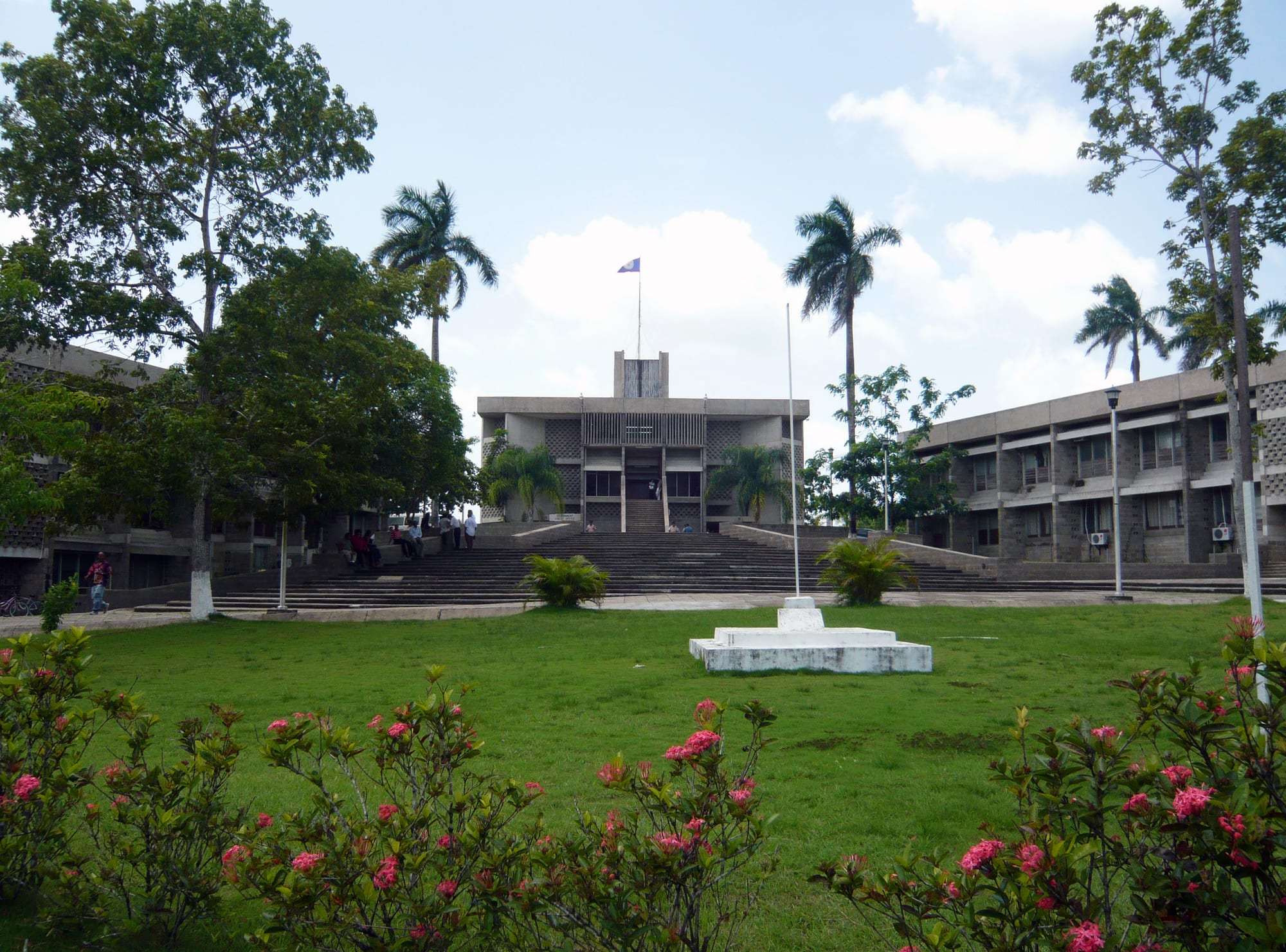
The grey concrete National Assembly Building at the top of wide steps, between two office blocks, behind a lawn and pink flowers

Cayo, Placencia & the South, Belize

Belmopan

The National Assembly Building on Independence Plaza in Belmopan. (Haakon S. Krohn / Wikimedia Commons · CC BY-SA 3.0)

The capital of Belize, a small planned city in the Cayo District, about 50 miles inland from the Caribbean. It was built after Hurricane Hattie wrecked Belize City in 1961 and became the seat of government in 1970. Today it is a quiet, green town of ministries, embassies and the national university, ringed by caves, parks and Maya country.

Neighbourhoods

  • Inside the Ring Road
    • First-time visitors
    • Architecture
    • Government district

    The heart of the planned city, enclosed by the Ring Road, which is just under 2.5 miles round. Most government buildings stand here around the National Assembly on Independence Plaza, and a large share of the land is given over to parkland; the Mexican embassy and the British High Commission stand on the North Ring Road.

    Open in Maps
  • The market and bus terminal
    • Local life
    • Best for food
    • Close to public transport

    The bus terminal and market complex, built in 2003, stand towards the south-west corner of the government campus. On Tuesday and Friday market days people from the surrounding towns and villages come in by bus.

    Open in Maps
  • Residential Belmopan
    • Quiet and residential

    Outside the centre, homes stand on quiet residential streets in the city the council promotes as 'The Garden City'. Church-run schools, churches, small shops and Chinese-owned restaurants are spread through these areas.

    Open in Maps
  • Roaring Creek and the highway villages
    • Local life
    • Rural Belize

    Communities close to the capital, such as Roaring Creek, Camalote, Esperanza and Georgeville, whose teams meet in a softball tournament early in the year; people from the surrounding villages come into the city by bus on market days.

    Open in Maps

Things to do

In the capital

  • National Assembly Buildinglandmark

    The home of both houses of Parliament, opened on 9 October 1970, whose grey stone and broad steps were designed to resemble a Maya temple, in a style drawing on Maya and Brutalist architecture; the public gallery is open during sittings.

    Open in Maps
  • George Price Centre for Peace and Developmentattraction

    A centre honouring George Price, Belize's first prime minister and National Hero, opened to the public in 2004 and used for community events and meetings.

    Open in Maps
  • Belize Archives and Records Servicemuseum

    The national archive, holding public records dating back to around the 1770s along with private collections of documents and photographs.

    Open in Maps
  • Belmopan marketmarket

    On Tuesdays and Fridays people from the surrounding towns and villages come in by bus to sell produce, food, clothes and household goods from booths in the centre.

    Open in Maps

Parks and caves nearby

  • Guanacaste National Parkpark

    A 50-acre park beside the Roaring Creek bridge, named after a huge guanacaste tree spared by loggers because its trunk divided into three, with more than two miles of trails and good birdwatching.

    Open in Maps
  • St. Herman's Blue Hole National Parkpark

    A national park off the Hummingbird Highway south-east of the city, with St Herman's Cave, the Crystal Cave and a jungle swimming pool called the Blue Hole for its vivid colour.

    Open in Maps
  • Nohoch Che'en (Caves Branch)park

    An archaeological reserve, also known as Caves Branch, made up of a network of limestone caves.

    Open in Maps

Short trips from the city

  • Actun Tunichil Muknalattraction

    A river cave used by the Maya for ceremonies, with pottery and calcified skeletons in its main chamber, visited only with official guides.

    Open in Maps
  • Belize Zooattraction

    A zoo founded in 1983 on the Western Highway, keeping more than 175 animals of about 48 species, all native to Belize, in natural forest along gravel trails.

    Open in Maps
  • Spanish Lookoutattraction

    A modern Mennonite farming settlement whose Plautdietsch-speaking people use cars and other modern conveniences, with light industry, furniture making and Belize's only producing oil field.

    Open in Maps
  • San Ignacioattraction

    The busy twin towns on the Macal River to the west, the base for the ruins of Xunantunich and Cahal Pech and for trips into the Mountain Pine Ridge.

    Open in Maps

Seasonal events

  • Softball tournamentearly in the year

    Teams from Roaring Creek, Camalote, Esperanza, Georgeville and other communities near the capital play a softball tournament.

Eat and drink

Long-standing places and food districts in Belmopan. Hours, ratings and directions come from your maps app, always current.

Belmopan classics

  • Market foodmarket

    Stalls at the market sell produce, snacks and cooked food, busiest early on Tuesdays and Fridays, before many close in the heat of the day.

    Open in Maps
  • Chinese-run restaurantsrestaurant

    Many of the city's restaurants are run by Chinese families and serve Belizean food — rice and beans, stew chicken, fried chicken — alongside Chinese dishes.

    Open in Maps

Experience Belmopan

History

In 1961 Hurricane Hattie struck Belize City, destroying about three-quarters of the houses and businesses in the low-lying coastal capital. The government decided to build a new capital on higher ground, safe from storm surges, with no costly land reclamation and room for industry. In 1962 a committee chose a site about 51 miles south-west of Belize City, just east of the Belize River, and in 1964 Premier George Price led a delegation to London to seek funding. During a visit by the British colonial secretary Anthony Greenwood, a monument at mile 49 on the Western Highway recorded the dedication of the site on 9 October 1965.

The name joins "Belize", the country's longest river, and "Mopan", a river of the area that flows into it. Building began in 1967, and the first phase was finished in 1970 for 24 million Belize dollars, against an original estimate of 40 million. The government moved in that year, and the National Assembly Building, designed to recall a Maya temple, opened on 9 October 1970.

Growth was slow. For thirty years the town was run by a development corporation, Recondev, until residents voted in a 1999 referendum for an elected council and Belmopan became a city in 2000. Foreign governments were reluctant to move their embassies from Belize City: the British High Commission opened at independence in 1981, and the United States embassy only in 2006. Major renovation of the National Assembly Building began in 2024, financed with a grant from the government of Taiwan.

Culture & Customs

Belmopan's identity is that of a capital: many residents work for the national government in administrative and technical posts, and the cluster of ministries around the National Assembly sets the rhythm of the week. Its people are of many backgrounds — Kriols, Garifuna, Mestizos and Maya, along with recent immigrants from China and Taiwan — drawn from every district by government jobs and the university.

The University of Belize has its central campus here, along with a Regional Language Centre where students from neighbouring Spanish-speaking countries come to study English, and its Black Jaguars team has won national championships playing out of the city. The Belmopan Choral Society, a Festival of Arts for schoolchildren and National Day activities are among the city's noteworthy events, and the George Price Centre, which honours the first prime minister, hosts community meetings and cultural events.

Nearly all of the schools are run by churches, in the church-and-state system that prevails in Belizean education, and Christian congregations of many denominations are central to community life. The city council promotes Belmopan as "The Garden City", and visitors find it quiet and laid back.

Daily Life

Belmopan had 20,754 people in 2022, making it the second-largest settlement in Belize after Belize City and the smallest national capital in the continental Americas by population. The city stands about 250 feet above sea level near the Belize River valley, with views of the foothills of the Mountain Pine Ridge.

The economy is built on government. Ministries, embassies and the university employ much of the workforce, and the number of businesses has grown to roughly 600, with five international banks and several local financial institutions. There is very little industry, though land has been set aside and an industrial park is planned near the municipal airstrip.

Many residents work in the large cluster of government buildings around the National Assembly. On Tuesdays and Fridays the market draws people in by bus from the surrounding towns and villages, busiest early before many booths close in the heat of the day. With four embassies and 29 consulates, Belize City still has most of the country's foreign diplomatic community.

Food

Belmopan eats like the rest of inland Belize. Rice and beans cooked in coconut milk with stew chicken, fried plantain and potato salad is the everyday midday meal, and Mestizo snacks now eaten across Belize — garnaches, panades and tamales — are common too. Boil-up, the Creole one-pot of ground provisions, fish or pig tail and egg, is a weekend dish.

Many of the city's restaurants are run by Chinese families and serve both Belizean dishes and Chinese food, from fried chicken to fried rice. The market on Tuesdays and Fridays is the place for produce from the surrounding farms and villages, and nearby Spanish Lookout's Mennonite farms are major producers of grain, poultry and dairy.

Marie Sharp's habanero sauce, made in the Stann Creek valley, is a national emblem found on tables here as across Belize. To drink, there is Belikin beer, rum and fresh fruit juices, and visitors are generally advised to stick to bottled water.

Planning tools

Budget

Belmopan is a working government town rather than a resort, so everyday costs — buses, market food, simple restaurants — are low. Places to stay are fewer and more business-oriented than in San Ignacio, and the main costs are guided cave and park trips and the lodges in the countryside around the city.

Daily Budget Midrange
USD 130–250 (hotel, restaurants, a guided cave or park trip)
Daily Budget Shoestring
USD 50–85 (guesthouse, market food and Chinese-run restaurants, buses)

Many tours need a minimum number of people, so ask the evening before which trips are running.

Best Time to Visit

The short dry season, with March and April the driest months, is best for caves and forest trails; the long wet season runs from May to January, with some rain even in the dry months. Independence Day falls on 21 September, and the hurricane risk is highest in September and October, although the capital was built inland to escape storm surges.

Suggested Number of Days

The city itself takes a day or less; most visitors pass through or stay a night on the way between Belize City, Cayo and the south. Three or four days allow for the caves, parks and zoo within easy reach.

First Visit
1–2 days
With Surroundings
3–4 days

Transportation

The city is small and can be walked, and taxis are available. The George Price Highway runs past it from Belize City to San Ignacio and the Guatemalan border, and the Hummingbird Highway heads south-east across the mountains to Dangriga. Buses from the terminal run along the highways to Belize City, San Ignacio and the south.

A car or a tour is the easiest way to reach the parks and caves along the highways.

Airport & Station Connections

The nearest scheduled flights are at Belize City, about 49 miles away, which has Philip S. W. Goldson International Airport and a municipal airport for domestic flights. Hector Silva Airstrip on the northern edge of Belmopan had no scheduled services as of 2024. Most people arrive by bus or car along the George Price Highway from Belize City.

Walkability

Walking is a good way to see the city: the Ring Road around the centre is just under 2.5 miles round, and the government buildings, market and bus terminal are close together.

Safety

Belize has a high overall homicide rate, but the violence is almost entirely gang-related and concentrated in specific parts of Belize City that visitors have no reason to enter. The tourist areas — the cayes, Cayo, Placencia, Hopkins — are comparatively safe, with the usual petty theft and occasional robberies. Belmopan itself is quiet and laid back, and the city council runs a community policing programme with the police.

Drink bottled water, visit caves only with licensed guides, and check river levels before cave trips in the wet season. Check current official travel advice before travelling.

Climate

A tropical monsoon climate with a long wet season from May to January and a short dry season, when March and April are the driest months. Monthly average temperatures change little through the year.

Summer
wet season (May to January): long and rainy; monthly averages through the year range from about 73 to 82°F
Winter
dry season (February to April): short, with March and April the driest months; monthly averages through the year range from about 73 to 82°F

Local Customs

Belmopan is a town of civil servants, students and families, more formal in dress on weekdays than the beach towns: neat clothes are expected in government offices and churches. Kriol, Spanish and English are all heard. Greet people before asking a question.

Ask before photographing people, and avoid photographing security staff at government buildings and embassies.

Common Payment Methods

The Belize dollar is pegged at two to one to the US dollar, and US dollars are accepted almost everywhere, often with change in Belize dollars. Five international banks and several local ones have branches in the city. Hotels and larger shops take cards; the market, buses and small restaurants need cash.