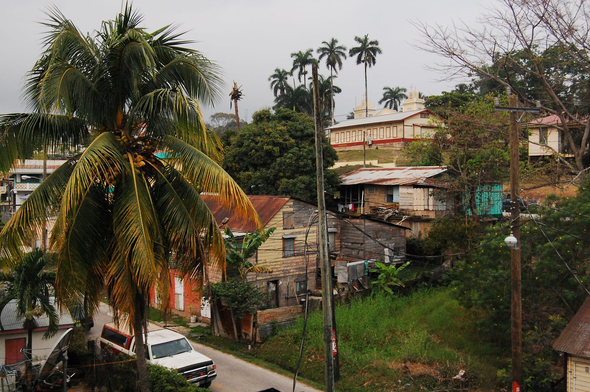
Wooden houses with rusty tin roofs on a hillside street in San Ignacio, with palms and a church on the ridge behind

Cayo, Placencia & the South, Belize

San Ignacio

A residential street on the hills of San Ignacio, with a church on the ridge above. (Rebecca Wilson from Portland, OR, USA / Wikimedia Commons · CC BY-SA 2.0)

The main town of western Belize, on the Macal River close to the Guatemalan border, joined to its twin town of Santa Elena. It grew from mahogany and chicle in the colonial era and is now the cultural and commercial hub of the Cayo District and the base for the Maya ruins, caves, rivers and pine uplands around it.

Neighbourhoods

  • Downtown San Ignacio
    • First-time visitors
    • Best for food
    • Close to public transport

    The compact centre on the west bank of the Macal, around Burns Avenue and the main square by the bus station. Most guesthouses, tour offices, gift shops and small restaurants are a few minutes' walk apart, and the market hall stands near the river.

    Open in Maps
  • Santa Elena
    • Local life
    • Quiet and residential

    The former separate town across the Macal River, now run together with San Ignacio as the 'Twin Towns'. It stretches along the Western Highway, with supermarkets, an Adventist hospital and homes, and is linked to the centre by the Hawkesworth suspension bridge and newer crossings.

    Open in Maps
  • The river valleys outside town
    • Nature
    • Quiet stays

    Along the Macal and Mopan rivers, and in villages such as Bullet Tree Falls a few miles from the centre, lodges and cabins sit among gardens and forest. Many offer bicycles, horse riding or river trips, and a local bus, taxi or car is needed to reach town.

    Open in Maps

Things to do

In and around town

  • Cahal Pechlandmark

    A Maya site on the hill above town, once the palatial home of an elite family, with evidence of settlement going back to about 1200 BC and a small museum of finds.

    Open in Maps
  • Hawkesworth Bridgelandmark

    A one-lane suspension bridge over the Macal River, built in 1949 with steel imported from Middlesbrough, England — the only drivable suspension bridge in Belize.

    Open in Maps
  • Branch Mouthpark

    The meeting of the Macal and Mopan rivers north of the centre, where they form the Belize River, with a small riverside park, a picnic area and a low hanging footbridge.

    Open in Maps
  • San Ignacio Marketmarket

    The market hall sells vegetables and everyday goods all week; on Saturday, the market day, people from across the district come in to trade produce and food.

    Open in Maps

Short trips from the town

  • Xunantunichlandmark

    A Late and Terminal Classic Maya ceremonial centre on a ridge above the Mopan River, within sight of Guatemala, reached by a hand-cranked ferry across the river at San José Succotz.

    Open in Maps
  • El Pilarlandmark

    The largest Maya site in the Belize River area, with more than 25 plazas, at the centre of a reserve that straddles the border with Guatemala north of San Ignacio.

    Open in Maps
  • Actun Tunichil Muknalattraction

    A river cave used by the Maya for ceremonies, where pottery with 'kill holes' and calcified skeletons, among them the 'Crystal Maiden', lie in the main chamber; cameras without a permit have been banned since 2012.

    Open in Maps
  • Barton Creek Caveattraction

    A river cave in the upper Barton Creek area, both an archaeological site and a popular trip by canoe.

    Open in Maps
  • Mountain Pine Ridge Forest Reservepark

    Upland pine forest protected since 1944, with waterfalls, pools and caves on the way south towards Caracol.

    Open in Maps
  • Caracollandmark

    One of the most important Classic Maya political centres, on the Vaca Plateau south of San Ignacio, crowned by the Caana pyramid.

    Open in Maps
  • Benque Viejo del Carmenattraction

    The westernmost town in Belize, on the Mopan River facing Melchor de Mencos in Guatemala — the border crossing for travellers heading to Flores and Tikal.

    Open in Maps

Seasonal events

  • La Ruta Maya Belize River ChallengeMarch

    A four-day canoe marathon that starts at the Hawkesworth Bridge and runs down the river to Belize City — the country's biggest sporting event, watched by thousands along the banks.

Eat and drink

Long-standing places and food districts in San Ignacio. Hours, ratings and directions come from your maps app, always current.

San Ignacio classics

  • Saturday marketmarket

    The place in town for fresh tortillas, tropical fruit, vegetables and snacks, at its busiest on Saturdays, the market day.

    Open in Maps
  • Street food on Burns Avenueneighborhood

    Small cafés on and around the main street sell Belizean fast food — tacos, burritos, salbutes, panades and garnaches — alongside sit-down restaurants.

    Open in Maps
  • Chinese restaurantsrestaurant

    A long-established Chinese community, most of it from Guangzhou, runs restaurants known for fried chicken, fried rice and chow mein.

    Open in Maps

Experience San Ignacio

History

The hill above the Macal River was settled long before the town: Cahal Pech, now on the edge of San Ignacio, shows signs of habitation from around 1200 BC, making it one of the oldest recognisably Maya sites in western Belize, and it was abandoned in the 9th century AD. The Spanish called the place El Cayo, the "island" — a creek once ran between the Macal and Mopan rivers outside town, leaving the land surrounded by water — and the name San Ignacio first appeared on a map in 1787. Locally the town is still often called Cayo.

Under British rule the district was logging country. Mahogany was cut along the rivers and floated to the coast, and later chicle, the gum of the sapodilla tree, was tapped in the forest, and El Cayo grew as the centre of both trades. It was declared a town on 19 October 1904. The highway from Belize City was finished in 1930, and the Hawkesworth Bridge across the Macal followed in 1949.

The creek that made El Cayo an island later dried up and was filled with gravel. Across the Macal, Santa Elena grew into a town of its own and has since been absorbed, the two forming the "Twin Towns", one of the largest urban areas in Belize. A two-lane bridge between them was built in 2018. Lying on the road to Guatemala and surrounded by sights, the town has drawn a growing number of visitors and is now the cultural and economic hub of the Cayo District.

Culture & Customs

San Ignacio is mostly Mestizo and, like the rest of Cayo, largely Spanish-speaking, with close ties across the border to Guatemala's Petén. Kriol families, some Mopan Maya and Lebanese residents, and a fairly large Chinese community — most of whom came from Guangzhou in waves in the mid-20th century — complete the mix, and their businesses line the main streets. The Mennonite farming settlement of Spanish Lookout lies a few miles outside town, and its people come in to trade.

The rivers shape the town's identity. Every March San Ignacio is the starting point of La Ruta Maya, a four-day canoe marathon from the Hawkesworth Bridge down to Belize City first organised partly to raise awareness of the river's history, culture and environment; it is the country's biggest sporting event and draws large crowds. The Maya ruins and caves around the town make the area one of the most popular parts of the country for visitors.

Schools are part of the town's life: Sacred Heart College, a Catholic high school and junior college, is one of the largest high schools in Belize, and Galen University and an agricultural campus of the University of Belize are just east of town. Its high schools include Catholic and Seventh-day Adventist schools.

Daily Life

The 2010 census counted about 17,900 people in San Ignacio and Santa Elena together, making the twin towns the second-largest settlement in the Cayo District after the capital, Belmopan. The town covers only about two and a half square miles, and most of the centre lies within a few minutes' walk.

Tourism shapes much of the economy: the area is one of the most popular in the country for visitors, and the town has places to eat and stay in every price range. Saturday is market day, when people from the surrounding villages come in to buy and sell produce. Galen University and the University of Belize's agricultural campus bring students, and Loma Luz, an Adventist hospital in Santa Elena, and the San Ignacio Hospital serve the area.

Traffic between the two halves of town crosses the Macal by two one-lane bridges, each carrying traffic one way, and a newer two-lane bridge. The town council is elected every three years, and the area sends three members to the House of Representatives.

Food

Cayo's food reflects its Mestizo and Guatemalan ties. Garnaches are crisp fried tortillas topped with beans, cabbage and cheese; panades are small fried turnovers of corn dough filled with fish or beans; salbutes are puffed fried tortillas topped with chicken; and tamales are corn dough wrapped in corn husk and steamed. Burritos and tacos are everyday fast food in town, sold by small cafés.

The market is the place to find fresh corn tortillas and tropical fruit from the river valleys, and Mennonite stalls bring cheese, bread, honey and pies in from the farms. As across Belize, rice and beans with stewed chicken is the usual midday meal.

San Ignacio's Chinese families run restaurants serving fried chicken, fried rice and chow mein, and the tourist trade has added cafés, pizzerias and restaurants offering everything from steak and seafood to a Sri Lankan menu. Belikin beer and fresh fruit juices are the usual drinks.

Planning tools

Budget

San Ignacio is one of the better-value bases in Belize: guesthouses, market food and buses are cheap, and the town has places to stay in every price range. The costs are the guided trips — the ATM cave, Caracol and the Mountain Pine Ridge — and the jungle lodges along the rivers outside town.

Daily Budget Midrange
USD 140–280 (riverside lodge or town hotel, restaurants, guided cave or ruin trips)
Daily Budget Shoestring
USD 50–85 (guesthouse or hostel bed, market and street food, buses)

Tours are usually cheaper booked in town than from the coast; many need a minimum number of people, so ask the evening before which trips are running.

Best Time to Visit

The dry months from about February to May are best for caves, ruins and the unpaved forest roads. In the wet season rivers rise and caves can close after heavy rain. March brings the La Ruta Maya canoe race, and September and October carry the highest hurricane risk.

Suggested Number of Days

The town itself needs only a day or so; most of the time goes on trips out into the district. Two or three days cover the nearest ruins and one cave, and four to six allow for the long trips into the pine uplands and across the border into Guatemala.

First Visit
2–3 days
With Surroundings
4–6 days

Transportation

The town is small and walked easily, and taxis wait near the bus stop and along Savannah Street. Shared taxis run to Bullet Tree Falls, and local buses reach the lodges outside town. Most sights beyond San Ignacio are visited by tour, by hire car or with a driver; a 4x4 helps on the Mountain Pine Ridge and Caracol roads.

Check river levels before cave trips in the wet season, and travel the Caracol road in daylight.

Airport & Station Connections

San Ignacio is on the George Price Highway about 63 miles west of Belize City and 22 miles west of Belmopan. Buses from Belize City usually take under two and a half hours, shuttles run door to door from the international airport, and small planes fly to a nearby airstrip. The Guatemalan border at Benque Viejo is a short ride west.

Walkability

The centre is foot-scaled — most things are within a few minutes' walk of the main square — and traffic is light. The climb to Cahal Pech is short but steep, and Branch Mouth is about a 20-minute walk. The lodges along the rivers are too far to walk to from town.

Safety

Belize has a high overall homicide rate, but the violence is almost entirely gang-related and concentrated in specific parts of Belize City that visitors have no reason to enter. The tourist areas — the cayes, Cayo, Placencia, Hopkins — are comparatively safe, with the usual petty theft and occasional robberies. Robberies have occurred near the western border, and trips to Caracol have at times travelled with security escorts. Cave trips involve wading and swimming, and flash floods can close caves and roads.

Visit caves and remote ruins only with licensed guides, take a taxi or move in a group at night, and leave cameras behind in Actun Tunichil Muknal. Check current official travel advice before travelling.

Climate

San Ignacio lies in the lowlands of the Cayo District, which has a clear dry season; the Mountain Pine Ridge to the south is cooler. The figures below are those given for the region as a whole, not for the town itself.

Summer
wet season (roughly June to November): 81–91°F and humid across the region, with heavy rain; rivers and caves can flood
Winter
dry season: 75–86°F in the region's lowlands, cooler in the Mountain Pine Ridge

Local Customs

Spanish is widely spoken alongside English and Kriol in a largely Mestizo town with Kriol, Maya, Lebanese and Chinese families too. Greetings matter: a 'good morning' before a question goes a long way. Dress is casual, but beachwear belongs at the river, not in town or at church. Ask before photographing people, especially at the market.

Tips for guides and restaurant staff are appreciated rather than required. Inside Actun Tunichil Muknal, remains and pottery must never be touched.

Common Payment Methods

The Belize dollar is pegged at two to one to the US dollar, and US dollars are accepted almost everywhere, often with change in Belize dollars. Several banks in town have ATMs. Hotels, lodges and tour companies take cards; buses, market stalls and small cafés need cash.