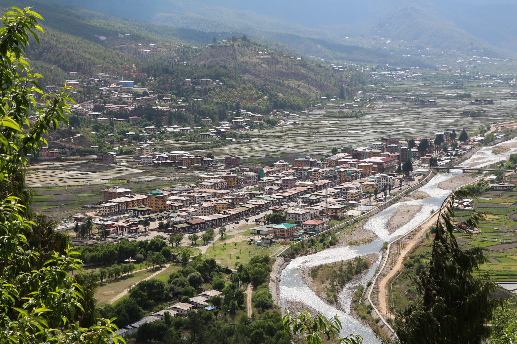
A single street of painted Bhutanese buildings on a valley floor, ringed by green paddy fields with a braided river and forested hills behind

Thimphu, Paro & Western Bhutan, Bhutan

Paro

Paro town and the Paro Chhu, seen from the hillside below Rinpung Dzong. (Bernard Gagnon / Wikimedia Commons · CC BY-SA 4.0)

A small town on the Paro Chhu in a broad valley of western Bhutan, about 2,200 metres up, with the country's only international airport on the valley floor. Paro grew around Rinpung Dzong and an old trade route to Tibet, and its fields of red rice, farmhouses and temples end at the cliff monastery of Taktsang, the Tiger's Nest.

Neighbourhoods

  • Paro town centre
    • First-time visitors
    • Shopping
    • Cafés

    One wide main street of two-storey buildings with carved and painted wooden windows, built in the 1980s to a single traditional design. Handicraft shops, general stores, bakeries and most of the town's restaurants are here, and the riverside park and cantilever bridge are a short walk away.

    Open in Maps
  • The dzong hillside
    • Historic district
    • Views over the valley

    Above the river stand Rinpung Dzong and, higher on the slope, the round Ta Dzong watchtower that holds the National Museum. A traditional covered bridge crosses to the town side, and the paths between them look down on the whole valley floor.

    Open in Maps
  • The lower valley and the airport
    • Hotels
    • Close to the airport

    South of town the valley widens around Bondey and the runway, with hotels, guesthouses and workshops along the road to Thimphu. It is the busiest part of the district in daylight and quiet once the day's flights have gone.

    Open in Maps
  • The upper valley
    • Quiet and residential
    • Walks
    • Farmhouse stays

    North of town the road runs past farmhouses, apple orchards and temples towards the Taktsang trailhead and the ruins at Drukgyel. Many of the valley's farmhouse lodgings and hot stone baths are along this stretch, with the mountains closing in at the end.

    Open in Maps

Things to do

Temples and dzongs

  • Paro Taktsanglandmark

    The Tiger's Nest, a monastery clinging to a cliff about 900 metres above the valley floor, where Guru Rinpoche is said to have meditated; the climb through pine forest takes several hours.

    Open in Maps
  • Rinpung Dzonglandmark

    The fortress-monastery built in the 17th century above the river, the district's administrative and monastic seat and the setting for the spring tshechu.

    Open in Maps
  • Kyichu Lhakhanglandmark

    One of Bhutan's oldest temples, traditionally attributed to the 7th-century Tibetan king Songtsen Gampo, with orange trees in its courtyard and much later additions.

    Open in Maps
  • Drukgyel Dzonglandmark

    The fortress at the head of the valley, built in 1649 to mark a victory over Tibetan forces and almost destroyed by fire in the early 1950s; a restoration was announced in 2016.

    Open in Maps

Museums and landmarks

  • National Museum of Bhutanmuseum

    The country's national collection of thangka paintings, masks, textiles, weapons and natural history, housed in and beside the old watchtower above the dzong.

    Open in Maps
  • Paro International Airporttransit hub

    Bhutan's only international airport, on the valley floor between steep ridges, where approaches are flown visually by a small number of certified crews.

    Open in Maps

Walks, passes and short trips

  • Haa Valleyattraction

    A quiet farming valley reached over the Chele La, at 3,988 metres the highest motorable pass in Bhutan, with the White and Black temples, less visited than Paro and about 60 kilometres away by road.

    Open in Maps
  • Jomolharitrail

    The sacred 7,300-metre peak on the Tibetan border at the head of the valley, the goal of the trek that starts from the road above Drukgyel.

    Open in Maps

Seasonal events

  • Paro Tshechuspring, March or April

    The valley's great festival, several days of masked dance in and around Rinpung Dzong, ending at dawn with the unrolling of a giant appliquéd thongdrel scroll.

  • LosarFebruary or March

    Bhutanese New Year, marked with family gatherings, temple offerings and archery matches in the villages along the valley.

Eat and drink

Long-standing places and food districts in Paro. Hours, ratings and directions come from your maps app, always current.

Where Paro eats

  • Main street restaurantsneighborhood

    The town's single main street holds most of its dining rooms, serving Bhutanese ema datshi and red rice alongside Indian, Nepali and Tibetan dishes and momos.

    Open in Maps
  • Paro town bakeries and cafésneighborhood

    A handful of small cafés and bakeries near the centre sell coffee, tea and cakes, and are the usual place to wait out a delayed flight.

    Open in Maps
  • Farmhouse meals in the valleyneighborhood

    Farmhouses along the valley cook for visitors, usually a spread of cheese and chilli dishes with the valley's red rice, often combined with a hot stone bath.

    Open in Maps

Experience Paro

History

The Paro valley is one of the oldest settled places in Bhutan. Kyichu Lhakhang is traditionally counted among the temples founded in the 7th century by the Tibetan king Songtsen Gampo, and in the 8th century Guru Rinpoche is said to have flown to the cliff above the valley and meditated in the cave that became Taktsang. Its position mattered: routes over the passes to Tibet made the valley a trading and military corridor, and grain grown on its wide floor fed the lamas and lords who competed for it.

The modern shape of the valley comes from the 17th century, when the Zhabdrung Ngawang Namgyal's government took control of the west. Rinpung Dzong was built above the river in the 1640s on the site of an earlier fortress, with the round Ta Dzong raised on the slope above it as a watchtower. Drukgyel Dzong was built at the head of the valley in 1649 to commemorate a victory over Tibetan invaders; it stood until a fire all but destroyed it in the early 1950s, and a restoration was announced in 2016. The Ta Dzong was converted into the National Museum in the 1960s.

Aviation changed the valley again. An airstrip on the valley floor grew into Bhutan's only international airport, with scheduled flights from 1983, and Paro became the point at which almost every visitor enters the country. Hotels, guesthouses and shops followed, and the main street was rebuilt in a single traditional style, while the fields around the town stayed in cultivation.

Culture & Customs

Paro's identity is bound to its dzong and its festival. The Paro Tshechu, held over several days in spring, fills the dzong courtyard and the ground above it with masked dances performed by monks and laymen, clowns working the crowd, and families in their best kira and gho; on the final morning, before dawn, a giant appliquéd thongdrel is unrolled against a wall and rolled away again before the sun can touch it. Taktsang, about 10 kilometres up the valley, is a pilgrimage for Bhutanese as much as a walk for visitors.

Valley life keeps older habits. Farmhouses are built of rammed earth with timber upper storeys and elaborately painted window frames, and many still dry chillies on their roofs in autumn. Hot stone baths — a wooden trough of water heated by river stones taken from a fire, with artemisia leaves added — are a household tradition offered to guests. Archery ranges sit at the edge of most villages, and matches bring singing and teasing between teams.

Because the airport is here, Paro is also the country's threshold: arriving and departing visitors, pilots, hotel staff and guides pass through constantly, and the town has more handicraft shops and cafés than its size would otherwise support. Residents are used to foreign visitors and tend to be reserved and courteous rather than insistent.

Daily Life

Paro town is small — a single main street and the settlements around it — and it functions as the service centre for a farming valley. Government offices are in the dzong, the market and shops are on the main street, and the schools, hospital and airport provide much of the paid employment along with hotels and tour operators.

Farming still sets the rhythm outside the town. The valley floor grows Bhutan's best-known red rice, transplanted in early summer and harvested in autumn, and the slopes carry potatoes, wheat, apples and vegetables, with cattle kept for milk and butter. Households divide the year between fieldwork, festivals and, for many families, a second income from tourism: a farmstay, a hot stone bath, a driving job or a shop.

Days are quiet and start early. The flight schedule sets a rhythm of its own, with the morning arrivals filling the road to town and the valley emptying again by mid-afternoon. Concerns are those of the country as a whole — rising prices, the cost of building, young people leaving for Australia and the Gulf — with a local edge in how much farmland is being turned into hotels and houses along a valley with little flat ground to spare.

Food

Paro is red rice country. The short, nutty grain grown on the valley floor is steamed and served with the cheese-and-chilli dishes that define Bhutanese cooking: ema datshi, whole green or dried chillies simmered with soft local cheese; kewa datshi with potatoes; and shamu datshi with mushrooms. Dried beef is cooked with chillies and radish, and phaksha paa pairs dried pork with chillies and vegetables.

Momos, steamed dumplings of beef, cheese or vegetables, are the common snack, and the valley's own dishes lean on what grows here — buckwheat, turnips, ferns gathered in spring, mustard greens, and apples that go into everything from raw eating to juice and brandy. Hoentay, the buckwheat dumplings of neighbouring Haa, appear on many menus, since the valley is only a pass away.

Drinks are as traditional as the food. Suja, tea churned with butter and salt, is offered on arrival at a farmhouse, sweet milk tea is drunk through the day, and ara, the home-distilled grain spirit, is served at festivals and to guests, sometimes warmed with butter and egg. Doma, areca nut with betel leaf and lime, is chewed widely and offered as a courtesy. In town, a small group of cafés and bakeries provides coffee and cakes, and larger hotels serve Indian, Chinese and Continental menus alongside Bhutanese dishes.

Planning tools

Budget

Paro's costs follow the national rules: most visitors pay the Sustainable Development Fee of USD 100 per person per night on top of hotels, food and transport, and many arrange the whole trip through a licensed Bhutanese operator who provides a guide and driver. The valley has the widest choice of upmarket hotels in the country, several of them well outside the town, which pushes the upper end of the daily figure well past the midrange.

Daily Budget Midrange
USD 400–600 (the fee, a mid-range valley hotel, guide and driver, restaurant meals and handicrafts)
Daily Budget Shoestring
USD 300–400 (the nightly Sustainable Development Fee, a simple guesthouse or farmstay, canteen meals and shared transport)

Extra spending is mostly on handicrafts, hot stone baths, drinks and tips; visitors from India travel under separate, much cheaper rules.

Best Time to Visit

Spring, from March to May, brings rhododendrons on the passes, blossom in the orchards and the Paro Tshechu. Autumn, from late September to November, is clearest for the walk to Taktsang and the views from Chele La. Winter is cold, bright and quiet; the monsoon months from June to August are cloudy, wet and the likeliest time for flight delays.

Suggested Number of Days

Two days suit the valley, one of them given over to the long climb to the cliff monastery. Three or four allow the pass to Haa and the upper valley as well. Fitness, altitude and the timing of the Paro flight all change the number.

First Visit
2 days
With Surroundings
3–4 days

Transportation

The town is small and the valley is served by a single main road along the river, with side roads climbing to villages and temples. Tourist travel is normally in the operator's vehicle with a driver; taxis run between the town, the airport and Thimphu. Ponies can be hired for part of the climb towards Taktsang, though not for the final steps.

Build a spare day into plans around the Paro flight, as cloud, wind and visibility regularly shift departure times.

Airport & Station Connections

Paro International Airport is the country's only international gateway, about 6 kilometres from the town, with a few regional international routes and domestic services to Bumthang, Gelephu and the east. Thimphu is about an hour's drive away, and overland travellers from India enter far to the south at Phuentsholing.

Walkability

The town itself is walked in fifteen minutes end to end, and the riverside path and the covered bridge to the dzong are easy strolls. Beyond that, distances in the valley are real: the dzong hillside is a steady climb, the temples and farmhouses are spread over several kilometres, and the Taktsang path is a steep ascent of several hours at altitude.

Safety

Paro is very safe, and crime against visitors is rare. The real risks are physical: altitude and steep ground on the Taktsang climb, loose stone and ice on the path in winter, cold and thin air at Chele La, and traffic on narrow valley roads without pavements. Stray dogs can be noisy at night.

Climb to Taktsang slowly with water, sun protection and shoes with grip, allow for cold at the pass, and keep clear of unfenced drops. Check current official travel advice before travelling.

Climate

A temperate highland climate at about 2,200 metres, with dry, bright winters, a warm wet summer and large differences between day and night. Snow falls on the valley floor a few times most winters.

Summer
mild and wet — June to August days are generally 20–26°C, with monsoon cloud and rain, especially in the afternoons
Winter
cold and clear — December to February days reach about 10°C and nights drop below freezing

Local Customs

Modest dress is expected at temples and dzongs, with long sleeves, covered legs and shoes removed at shrine doors; the working parts of Rinpung Dzong are closed to visitors. Walk clockwise around chortens and prayer wheels. Bhutanese national dress is worn by officials and by most people attending the tshechu, and photography is usually not allowed inside shrines or at certain festival dances.

Ask before photographing people, monks or the inside of a farmhouse, and take the guide's lead on where visitors may go at Taktsang.

Common Payment Methods

The currency is the ngultrum, pegged one to one with the Indian rupee, which also circulates. There are banks and ATMs in the town and at the airport, but machines can run out of cash, and handicraft shops, taxis and farmhouses often prefer notes to cards. Larger hotels take cards, and residents pay each other increasingly by mobile QR code.