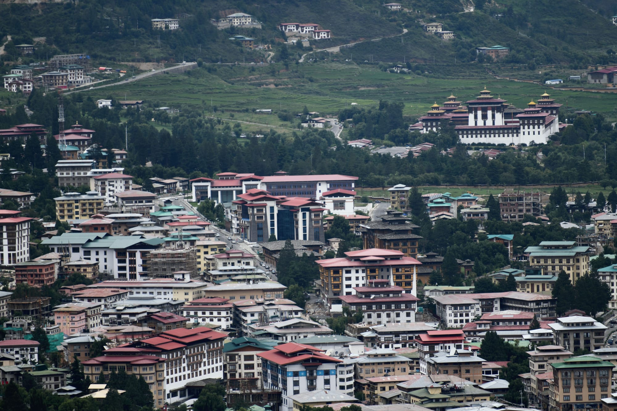
Rows of low Bhutanese buildings with red and green roofs filling a valley floor, with a large white dzong and green fields on the slope beyond

Thimphu, Paro & Western Bhutan, Bhutan

Thimphu

Central Thimphu seen from the south, from the Kuensel Phodrang ridge. (Christopher J. Fynn / Wikimedia Commons · CC BY-SA 4.0)

Bhutan's capital and largest city, strung along the Wang Chhu river in a valley at about 2,300 metres in the west of the kingdom. A small settlement around its dzong until it replaced Punakha as the seat of government in the 1950s, it is now a town of ministries, monks, students and shops, built under rules that require traditional rooflines and painted timber façades.

Neighbourhoods

  • Norzin Lam and the town centre
    • First-time visitors
    • Shopping
    • Cafés

    The main street and the blocks around it hold most of the city's shops, handicraft stores, banks, restaurants and cafés. The Clock Tower Square nearby is used for concerts and gatherings, and the junction where a white-gloved policeman directs traffic by hand is a short walk away.

    Open in Maps
  • Chang Lam and the riverside
    • Hotels
    • Sport
    • Close to the centre

    The parallel road nearer the Wang Chhu, with hotels, the bus station and Changlimithang Stadium, where archery and football are played. Riverside paths run north and south from here, and the weekend market is at the northern end.

    Open in Maps
  • Motithang and Kawajangsa
    • Museums
    • Quiet and residential
    • Walks

    A wooded slope on the western side of the valley, higher and cooler than the centre. The National Library, the arts school and the takin preserve are up here among embassies, guesthouses and the trailheads for walks into the pine forest above the city.

    Open in Maps
  • Changangkha and Zilukha
    • Temples
    • Views over the city

    A residential hillside between the centre and Motithang, built around the old Changangkha Lhakhang. Streets of flats and family houses climb the slope, and the ridge gives long views down the valley.

    Open in Maps
  • Dechencholing and the northern valley
    • Quiet and residential
    • Countryside on the doorstep

    North of the dzong the valley narrows into a greener stretch of fields, monasteries and government housing, with the royal palace grounds and the road that leads to the trailheads for Cheri and Tango.

    Open in Maps
  • Babesa and Olakha
    • Local life
    • Budget stays

    The southern end of the city, where much of Thimphu's growth has gone — apartment blocks, workshops, warehouses and the expressway running down the valley towards Simtokha Dzong and the road to Paro and Phuentsholing.

    Open in Maps

Things to do

Dzongs, temples and landmarks

  • Tashichho Dzonglandmark

    The fortress-monastery on the west bank of the Wang Chhu that holds the throne room, government offices and the summer seat of the central monk body.

    Open in Maps
  • Buddha Dordenmalandmark

    A gilded bronze Shakyamuni Buddha more than 50 metres high on the ridge of Kuenselphodrang south of the city, with thousands of smaller Buddha figures inside.

    Open in Maps
  • National Memorial Chortenlandmark

    A white stupa built in 1974 in memory of the third king, circled all day by residents turning prayer wheels and counting rounds.

    Open in Maps
  • Changangkha Lhakhanglandmark

    Probably the oldest surviving temple in Thimphu, on a ridge above the town, where parents bring young children to be blessed by its protective deity.

    Open in Maps
  • Simtokha Dzonglandmark

    Built by the Zhabdrung in 1629 at the southern entrance to the valley, generally held to be the oldest surviving dzong in Bhutan, and now a school of Dzongkha studies.

    Open in Maps

Museums and craft institutions

  • Royal Textile Academy of Bhutanmuseum

    A textile academy and museum in Kawajangsa showing Bhutanese weaving, from everyday kira and gho to royal dress and the silk work of the eastern districts.

    Open in Maps
  • Folk Heritage Museummuseum

    A restored three-storey rammed-earth farmhouse furnished as a rural household of the 19th century, with a mill and kitchen garden.

    Open in Maps
  • National Library of Bhutanmuseum

    The national collection of Buddhist texts and Bhutanese printing blocks, housed in a temple-like building in Kawajangsa.

    Open in Maps

Parks, wildlife and sport

  • Motithang Takin Preservepark

    A fenced patch of forest above Motithang holding takin, Bhutan's shaggy national animal, kept here after an attempt to release a former zoo's herd failed.

    Open in Maps
  • Changlimithang Stadiumattraction

    The national stadium beside the river, used for football, archery tournaments and national ceremonies, on the site of a decisive 19th-century battle.

    Open in Maps
  • Phajoding Monasterytrail

    A monastic complex high on the slope above Motithang, reached by a steep forest walk of a few hours and a common short trek out of the city.

    Open in Maps

Short trips from the city

  • Cheri Monasterylandmark

    The retreat founded by the Zhabdrung in 1620 at the head of the valley, about 15 kilometres north, reached by a bridge and a climb through forest.

    Open in Maps
  • Tango Monasterylandmark

    A Buddhist university on the slope opposite Cheri, founded in the 13th century and rebuilt in the 17th, a walk of roughly an hour from the road.

    Open in Maps
  • Dochulaviewpoint

    The pass on the road east towards Punakha, at about 3,100 metres, crowned by 108 memorial chortens with a line of Himalayan peaks visible on clear mornings.

    Open in Maps

Seasonal events

  • Thimphu Tshechuautumn, September or October

    The capital's great festival, four days of masked dances in and around the courtyards of Tashichho Dzong, drawing crowds in their best kira and gho.

  • Thimphu Drubchenautumn, days before the tshechu

    An older ritual cycle held at the dzong just before the tshechu, centred on the protective deity of Bhutan rather than on public dance.

  • LosarFebruary or March

    Bhutanese New Year, marked with family meals, archery, offerings at temples and a general quietening of business in the city.

  • National Day17 December

    The anniversary of the first king's coronation in 1907, marked with mass displays, songs and dances, often at Changlimithang Stadium.

Eat and drink

Long-standing places and food districts in Thimphu. Hours, ratings and directions come from your maps app, always current.

Markets and food streets

  • Centenary Farmers' Marketmarket

    The large covered market beside the Wang Chhu, busiest from Friday to Sunday, selling red rice, mounds of fresh and dried chillies, datshi cheese, strings of hard chugo, ferns, oranges and yak butter.

    Open in Maps
  • Norzin Lam restaurantsneighborhood

    The main street and its side lanes hold most of the city's eating places, from Bhutanese canteens serving ema datshi and red rice to Indian, Nepali and Tibetan kitchens and a handful of Thai and Japanese rooms.

    Open in Maps
  • Clock Tower Square cafésneighborhood

    Coffee houses and bakeries cluster in the blocks around the square, a habit of the last two decades and the usual meeting place for students and office workers.

    Open in Maps
  • Momo and snack stalls of the town centreneighborhood

    Small rooms and stalls across the centre steam beef, cheese and vegetable momos to order, usually with a fiery ezay chilli relish on the side.

    Open in Maps

Experience Thimphu

History

The Thimphu valley was farmland and monastic land long before it was a capital. Its dzong is traditionally traced to 1216, when the lama Gyalwa Lhanangpa built a fortress on the ridge above the present dzong, and in 1629 the Zhabdrung Ngawang Namgyal raised Simtokha Dzong at the valley's southern entrance, one of the first buildings of the unified state. By the 1640s his government had taken over the Thimphu dzong, which became the summer seat of the ruling hierarchy while Punakha, lower and warmer, served as the winter capital.

For three centuries Thimphu remained a scatter of farmhouses, temples and a market below the dzong. The change came under the third king, Jigme Dorji Wangchuck, who moved the permanent seat of government here in the 1950s and made it the capital in the early 1960s, as Bhutan opened to the outside world, abolished serfdom and joined the United Nations. Tashichho Dzong was rebuilt between 1962 and 1968, largely in traditional technique and without architectural drawings, to hold the new ministries.

Roads, schools, a hospital and the first shops followed. The National Assembly met here, and in 2008 the coronation of the fifth king and the country's first general election under the new constitution both took place in the capital. Since then the valley has filled steadily with concrete apartment blocks built to a building code that requires Bhutanese windows, cornices and roofs, and the city has spread south towards Simtokha and north towards Dechencholing.

Culture & Customs

Thimphu is where national culture is defined and taught. The National Institute for Zorig Chusum trains students in the thirteen traditional arts, the Royal Academy of Performing Arts keeps the dance and song repertoire, and the textile and folk museums present weaving and rural life as heritage. Civil servants wear the gho and kira to work, and a formal scarf — the white kabney for men, the rachu for women — is required in the dzong.

The religious year gives the city its biggest occasions. The Thimphu Drubchen and the Thimphu Tshechu fill the dzong and its grounds in autumn with masked dances, atsara clowns and families picnicking in their finest cloth. Circuits of the Memorial Chorten are part of many residents' daily routine, particularly for older people, who walk and tell their beads there from early morning.

Archery is the national sport and the loudest one: teams at Changlimithang and the valley's ranges shoot at a distant target, dancing and singing mocking songs when they hit. Football is followed closely, and the stadium also stages national ceremonies. Alongside this runs a young urban culture of cafés, karaoke, film and hip hop — Bhutanese cinema is made here — and the constant fact of emigration, with large numbers of young Thimphu residents now working in Australia.

Daily Life

Thimphu's population was about 91,000 in 2011 and has grown steadily since, making it easily the largest city in a country of roughly 800,000, and it has grown mainly by migration from the villages. The economy is built on government: ministries, the judiciary, the armed forces and the monk body, with construction, retail, hotels, banking and a small technology sector alongside. Many households keep ties to family farms and return for harvests and funerals.

The day starts early. Offices open in the morning and close in the late afternoon; students in school uniform and monks in maroon are part of the street scene; shops on Norzin Lam stay open into the evening. Life is lived along the valley floor, with the newer districts of Babesa and Olakha in the south taking most of the population growth, and older neighbourhoods on the slopes above the centre. Weekends centre on the farmers' market, archery matches, temple visits and, for those with vehicles, picnics up the valley.

The pressures are those of a fast-growing small capital: rents and food prices, traffic on a few narrow roads, waste and water supply, and youth unemployment that has pushed thousands abroad in recent years. Policy debates about how to keep people in the country, and about the Gelephu economic zone in the south, are followed closely here.

Food

Thimphu eats the national dishes, with more choice than anywhere else in Bhutan. Ema datshi — green chillies stewed with soft local cheese — is the staple, eaten with red rice from the Paro valley, and its variations run through kewa datshi with potatoes and shamu datshi with mushrooms. Dried beef and jasha maru, a spiced chicken stew, are common on a family table, and phaksha paa pairs dried pork with chillies, radish or turnip.

Momos, steamed dumplings filled with beef, cheese or vegetables, are the snack of the city, sold from small rooms and stalls and eaten with fiery ezay relish. Hoentay, the buckwheat dumplings of the Haa valley, and puta, Bumthang's buckwheat noodles, appear on Thimphu menus as regional specialities. Suja, tea churned with butter and salt, is offered at any hour, alongside sweet milk tea; ara, the home-distilled grain spirit, belongs to festivals and hospitality rather than to restaurants.

The Centenary Farmers' Market is the best single view of the local diet: chillies fresh, dried and powdered, datshi cheese, strings of rock-hard chugo made from yak milk, ferns and wild greens, buckwheat, oranges and butter. Indian and Nepali canteens are everywhere, reflecting the workforce and the trade with the plains, and cafés serving espresso, cakes and Bhutanese red rice salads have multiplied in the centre.

Planning tools

Budget

Costs in Thimphu are set by national policy rather than by the city. Most visitors pay the Sustainable Development Fee of USD 100 per person per night, on top of accommodation, food and transport, and many book the whole trip through a licensed Bhutanese operator who arranges guide, driver and hotels. Thimphu has the widest range of hotels in the country, from simple guesthouses to luxury resorts up the valley, so the daily figure varies more here than anywhere else.

Daily Budget Midrange
USD 400–600 (the fee, a mid-range hotel, guide and driver, restaurant meals and craft shopping)
Daily Budget Shoestring
USD 300–400 (the nightly Sustainable Development Fee, a simple guesthouse, canteen meals and shared transport)

Spending money in Thimphu goes mainly on handicrafts, textiles, drinks and tips; visitors from India travel under separate, much cheaper rules.

Best Time to Visit

Spring, from March to May, and autumn, from late September to November, are the settled seasons, with clear air and the Thimphu Tshechu in early autumn. Winter days are bright and cold and the city is quiet. The monsoon, from June to August, brings cloud, rain and landslides on the roads in and out.

Suggested Number of Days

Two days cover the capital itself. Allow three or four to add the head of the valley, the monasteries above it and a crossing of the pass to the east. Altitude, festival dates and the pace of the guided arrangements all change the number.

First Visit
2 days
With Surroundings
3–4 days

Transportation

Thimphu is small enough that most of the centre is walked. Tourist travel is normally in the operator's vehicle with a driver, which also covers the sights on the ridges and at the head of the valley. Taxis are plentiful and shared, city buses run along the valley, and there are no traffic lights — the main junction is worked by a policeman in a raised booth.

Distances up the valley sides are longer and steeper than they look on a map, so plan to be driven to the higher temples and walk back down.

Airport & Station Connections

Paro International Airport, the country's only international airport, is about an hour's drive west, down the Paro valley and up the Wang Chhu. Overland travellers from India enter at Phuentsholing and climb for around six hours. Domestic flights from Bumthang and the east also land at Paro, and all arrivals are met by the operator's driver.

Walkability

The centre is compact and level along the valley floor: Norzin Lam, the Clock Tower, the stadium and the weekend market are all within twenty minutes of each other on foot, and pavements are in reasonable condition. Everything else climbs. The temples, museums and residential districts sit on steep slopes, and at 2,300 metres walking uphill feels harder than the distance suggests until the body adjusts.

Safety

Thimphu is a very safe city and violent crime is rare. The practical issues are altitude on arrival, cold nights, traffic on narrow roads without pavements outside the centre, and stray dogs that bark through the night and are best not approached. Petty theft is uncommon but not unknown in crowds at festivals.

Go gently at altitude on arrival, carry warm layers for the evening, and keep to lit roads at night. Check current official travel advice before travelling.

Climate

A temperate highland climate at about 2,300 metres, with four clear seasons, dry bright winters and a wet summer. Nights are cold for much of the year, and the difference between sun and shade is sharp.

Summer
mild and wet — June to August days are usually 20–25°C, with heavy monsoon cloud and rain
Winter
cold and dry — December to February days reach about 10–12°C and nights fall below freezing, with occasional snow

Local Customs

The gho and kira, the national dress, are worn to offices, schools and dzongs, and visitors are expected to dress modestly, with long sleeves and covered legs, when entering a temple or dzong. Shoes and hats come off inside temples, and parts of a working dzong are closed to the public. Walk clockwise around chortens, prayer wheels and mani walls. Tobacco sales are tightly restricted and smoking in public places is not allowed.

Ask before photographing people or monks, do not photograph inside temple shrines, and follow the guide's lead on where visitors may go inside the dzong.

Common Payment Methods

The currency is the ngultrum, pegged one to one with the Indian rupee, which also circulates. Thimphu has the country's best banking and most card acceptance, with ATMs along Norzin Lam and Chang Lam, but machines can be out of service and cards are refused by many small shops and stalls. Cash in small notes is needed for the market, taxis and offerings, and mobile payment by QR code is widespread among residents.