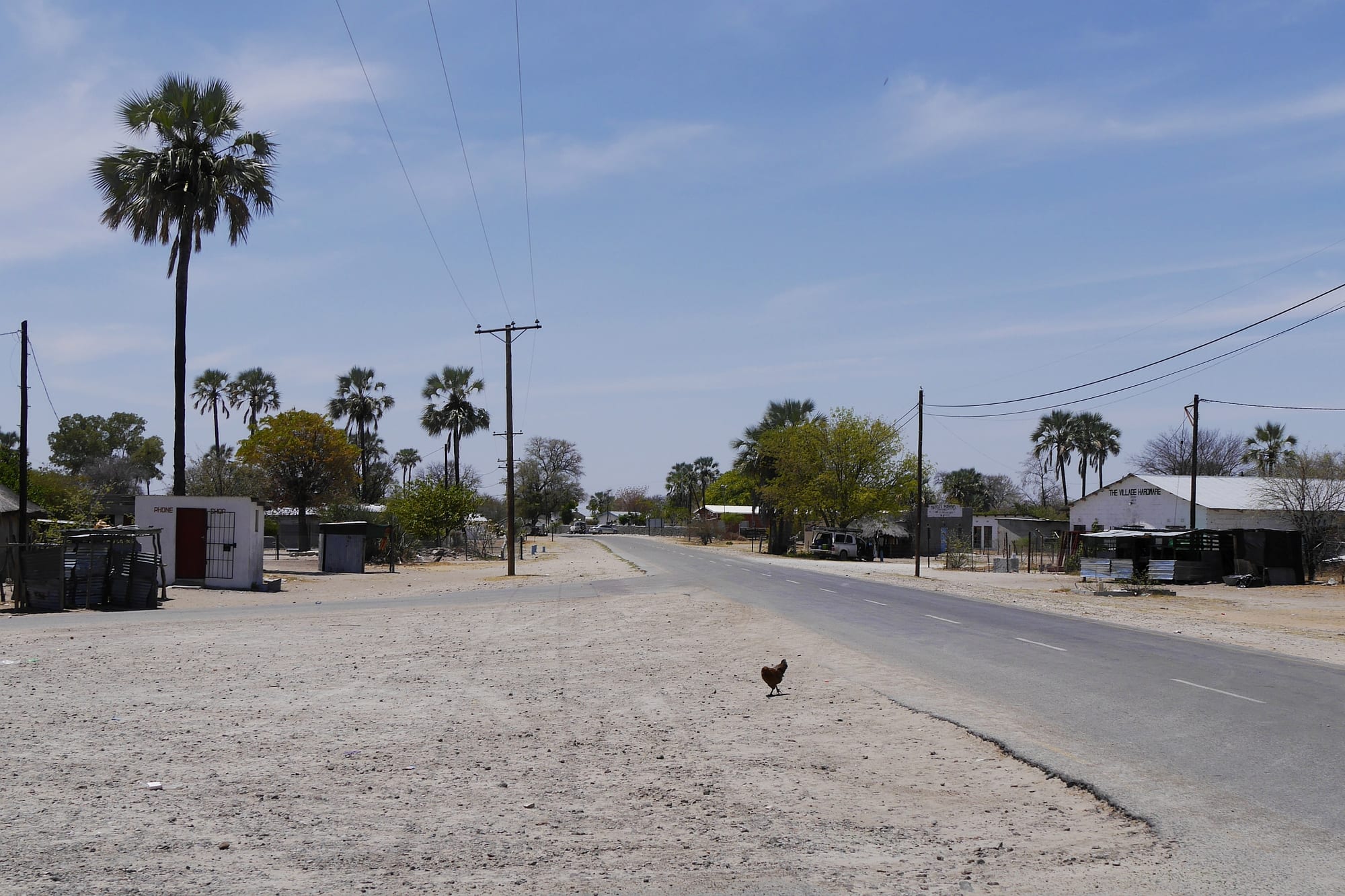
A wide empty tarred road through Gweta, with palm trees, low shops and a chicken crossing the sand verge

Francistown & the Central District, Botswana

Gweta

The main road through Gweta, lined with palms and small shops. (Erdkröte / Wikimedia Commons · CC BY-SA 3.0)

A village in Botswana's Central District, on the tarred road between Nata and Maun, set among palms and baobabs on the northern edge of the Makgadikgadi salt pans. Long a place of cattle posts and boreholes, it has become a staging point for trips onto the pans and north to Nxai Pan National Park, and keeps the slow rhythm of a farming village.

Neighbourhoods

  • The main road
    • First-time visitors
    • Fuel and supplies
    • Close to transport

    The tarred A3 runs straight through the village, and almost everything a traveller needs sits along it — a filling station, general dealers, bottle stores, a few small guesthouses and the stop where long-distance buses pull in. Palms and old baobabs stand between the buildings.

    Open in Maps
  • The village behind the road
    • Local life
    • Quiet and residential

    North and south of the tar, sandy tracks lead between fenced compounds of block-built and thatched houses, goats, donkeys and mophane-shaded yards. The kgotla, the clinic and the schools are here, and life is quiet apart from early mornings and the evening return of cattle.

    Open in Maps
  • The pans edge
    • Wildlife and the pans
    • Stargazing
    • Quiet

    South of the village the ground opens into grassland and palm islands that run out onto Ntwetwe Pan, where the lodges and camps that organise pan trips stand well apart from one another. There is no settlement out here, only tracks, cattle posts and an enormous horizon.

    Open in Maps

Things to do

Short trips onto the pans

  • Ntwetwe Panattraction

    A flat white crust of salt and clay stretching south of the village, dry and blinding for most of the year and shallowly flooded in wet ones.

    Open in Maps
  • Makgadikgadi Panattraction

    The bed of a vast lake that dried up long ago, now a complex of salt flats, grassland and palm islands that the region describes as among the largest salt flats in the world.

    Open in Maps
  • Makgadikgadi Pans National Parkpark

    Protected grassland along the Boteti river, crossed by zebra and wildebeest in the wet season and holding game at the river late in the dry.

    Open in Maps

Short trips to the baobabs and Nxai Pan

  • Nxai Pan National Parkpark

    A grassy fossil pan where springbok, zebra, giraffe and their predators gather after the rains.

    Open in Maps
  • Baines' Baobabslandmark

    A cluster of ancient baobabs on a pan edge, named after the artist Thomas Baines, who first described them for Western botany in the 1860s.

    Open in Maps
  • Chapman's Baobablandmark

    A huge baobab about 25 m round, named after the hunter James Chapman and used as a navigation beacon and an informal post office by nineteenth-century travellers, who cut inscriptions into its trunk; it fell in 2016.

    Open in Maps
  • Green's Baobablandmark

    A large baobab carved with the names of nineteenth-century traders and travellers, used as a landmark on the route to the interior.

    Open in Maps

Eat and drink

Long-standing places and food districts in Gweta. Hours, ratings and directions come from your maps app, always current.

Eating in the village

  • Stalls and takeaways on the main roadneighborhood

    The roadside places along the A3 sell grilled and stewed meat with pap, fat cakes, chips and cold drinks to bus passengers, truck drivers and villagers, and are the only everyday eating places in Gweta.

    Open in Maps
  • General dealers and bottle storesmarket

    Small shops stock maize meal, sorghum, tinned goods, bread and beer; self-drivers heading for the pans or Nxai Pan buy here, though the choice is wider in Nata or Maun.

    Open in Maps

Lodge kitchens

  • Camps and lodges on the pans edgerestaurant

    The camps south of the village cook set meals for their guests, usually braaied meat, stews and salads, and are where most visitors on a pans trip eat.

    Open in Maps

Experience Gweta

History

Gweta grew where water could be found at the northern edge of the Makgadikgadi, in a belt of grass, palms and baobabs between the salt pans and the mophane woodland. The name is usually explained by the large burrowing frogs that survive the dry season buried in the pan margins and call loudly when the rains come, a sound the village is said to be named for. Long before any settlement, the pans were a landmark on the hunting and trading routes north-west towards Lake Ngami and the Delta, and the great baobabs south of the village carry names cut into them by nineteenth-century travellers.

For most of its modern history Gweta was a Bangwato cattle village, one of a scattered chain of settlements dependent on boreholes, with families moving between the village, the lands where sorghum and maize were sown, and the cattle posts out towards the pans. Veterinary fences built to control foot-and-mouth disease cut across those movements in the twentieth century and shaped where animals could be grazed and sold.

The tarring of the road between Nata and Maun changed the village more than anything else, turning it into a stop on the route to the Okavango and giving the settlement fuel, shops and passing trade. In recent decades the pans themselves have become a destination, and camps and lodges opened around the village to run trips onto the salt, adding tourism to a still largely pastoral economy.

Culture & Customs

Gweta is a Setswana-speaking village of the Central District, and its social life follows the pattern of rural Botswana: the kgotla for meetings and disputes, the church on Sunday, and family gatherings that fill a compound for days at a time for weddings and funerals. Cattle are wealth, inheritance and standing as much as food, and conversations turn on rain, grazing, boreholes and the price of beasts.

The surrounding Boteti country is mixed. Bangwato and Bakalanga families live alongside Bakgalagadi, Bateti and San communities whose knowledge of the pans, their water and their animals underpins much of the guiding work done from the lodges; some of that knowledge is now sold to visitors as tracking and bush walks, which brings both income and argument about who benefits.

Music and dance at village celebrations are choral and percussive, with the setapa among the dances still performed, and traditional dress appears at kgotla occasions and national holidays. Visitors are treated with easy politeness, but the village is not a spectacle: greetings come before questions, elders before younger people, and permission before photographs. The baobabs that stand among the houses are landmarks with their own local histories, and are treated with a respect that outsiders do not always notice.

Daily Life

Gweta is a substantial village by the standards of this thinly peopled district. Days begin early and the middle of the day is spent in shade; cattle and goats move out at dawn and come back towards the compounds in the late afternoon, and the sound of the village at dusk is donkeys, dogs and returning herds.

The economy rests on livestock, government employment — the school, the clinic, the council — and tourism. Lodge and camp work, guiding, driving and maintenance draw young people who might otherwise leave for Francistown or Maun, and the seasonal harvest of mophane caterpillars and wild fruits adds real income to rural households. Rain-fed fields of sorghum, maize and melons are planted in good years and fail in dry ones, and drought is the recurring hardship.

Services are basic: a clinic rather than a hospital, primary and secondary schooling, boreholes and standpipes, mobile coverage in the village and almost none beyond it. Elephants and other wildlife moving between the parks and the pans sometimes reach the fields and water points, an ordinary complication of life here. Serious shopping, banking and medical care mean a bus ride to Nata, Francistown or Maun.

Food

Food in Gweta is the plain cooking of rural Botswana. The staple is bogobe, porridge made from sorghum or maize meal, eaten with a relish of beef, goat or chicken stew, morogo — wild or cultivated greens — or dikgobe, samp and beans cooked together. Seswaa, beef or goat boiled long and pounded soft with little more than salt, appears at weddings, funerals and kgotla gatherings rather than as everyday food.

Phane, the fat caterpillars of the mophane emperor moth, are gathered in the woodlands after the rains, gutted, boiled and dried, and eaten fried with onion and tomato or as a dry snack; in season they are both a food and a source of cash for families who collect them by the sackful. Madila, soured milk, comes from the cattle posts, and biltong keeps meat through the dry months. Wild fruits, above all the marula and the fruit of the baobab, are eaten fresh in season, and baobab pulp makes a sharp, refreshing drink.

The roadside stalls on the A3 sell grilled meat, fat cakes and roasted maize to travellers, and bottle stores sell lager and Chibuku, the commercial sorghum beer, alongside home-brewed drinks made in the compounds. Lodge kitchens out on the pans edge cook braais and international dishes for their guests.

Planning tools

Budget

Gweta is cheap to pass through and expensive to stay at properly. A bed in the village, food from the road and a bus fare cost very little; the pan activities that bring people here — guided drives, quad trips, meerkat visits, a night out on the salt — are priced as safari activities and are quoted per person. Park fees and fuel add up for self-drivers, and there is no cheap way onto the pans without a 4x4.

Daily Budget Midrange
USD 130–320 (a lodge at the pans, a share of 4x4 hire, park fees and a guided pan or wildlife trip)
Daily Budget Shoestring
USD 35–70 (a village guesthouse or campsite, food from the roadside stalls, buses along the A3)

Camping is far cheaper than the pan lodges, and fuel should be taken on wherever it is available, since stations between Nata and Maun are few.

Best Time to Visit

April to October is dry, cool at night and the easiest time to drive onto the pans. December to March brings the rains, the zebra and wildebeest to the Makgadikgadi grasslands and Nxai Pan, and birds to the flooded pans, but also mud, heat and tracks that close. September and October are dry and very hot.

Suggested Number of Days

A night or two covers the village and one trip onto the pans. Three or four days allow the national parks to the north and west as well. Distances, park permits and the need for a 4x4 or a guided vehicle set the pace far more than the number of sights does.

First Visit
1–2 days
With Surroundings
3–4 days

Transportation

The village is walkable end to end, and most people get around on foot or by donkey cart. Buses and minibuses along the A3 link Gweta with Nata, Francistown and Maun and stop on the main road. Everything off the tar — the pans, the cattle posts, the parks — needs a 4x4 with high clearance, and most visitors travel in a lodge vehicle or their own hired one.

Salt crust can hide soft mud, so tracks made by others are the safe ones; a vehicle should never be taken onto a wet pan.

Airport & Station Connections

Gweta sits on the tarred A3 between Nata, about 100 km east, and Maun, roughly 200 km west, so it is two to three hours by road from either. Francistown is about 290 km east. Long-distance buses and minibuses on the Francistown–Maun run pass through daily and set down on the main road. The nearest airports with scheduled flights are Maun and Francistown; lodges arrange road transfers.

Walkability

Flat, sandy and small enough to cross on foot in half an hour, though the sun is fierce and there is little shade between the baobabs. Away from the tar there are no pavements, only sand tracks shared with goats, donkeys and cattle. Walking out of the village towards the pans is not advisable, and walking anywhere after dark needs a torch.

Safety

The village is quiet and crime against travellers is uncommon; ordinary care with valuables is enough. The real risks are on the road and on the pans — cattle, donkeys and wildlife on the A3 after dark, heat and glare by day, and the ease of becoming stuck or lost on the salt, where there is no mobile signal and help is hours away.

Drive only in daylight, carry extra water and recovery gear onto the pans, and tell someone the route. Check current official travel advice before travelling.

Climate

Hot and semi-arid, with a single rainy season of afternoon thunderstorms from about November to March and a long dry season from April to October. Southern-hemisphere summer falls in December to February; winter nights on the open pans can drop close to freezing.

Summer
hot, roughly 32–40°C by day, humid after storms, with green grass on the pan edges
Winter
dry and clear, about 22–27°C by day, with cold nights and sharp glare off the salt

Local Customs

This is a conservative rural village where greetings matter: a short exchange in Setswana — dumela mma or dumela rra — before asking anything is normal courtesy. Elders are addressed first and respectfully, and the kgotla is a place of authority rather than a sight. Modest dress is usual, cattle and compounds are private property, and photographs of people or their homes should be asked for first.

Tipping is not obligatory but is usual for guides and lodge staff; alcohol is sold through bottle stores under restricted hours, and drinking in public is frowned on.

Common Payment Methods

The currency is the Botswana pula. Cash is needed in the village for stalls, shops and fares, and the range of card acceptance is limited; bank and ATM facilities are far more reliable in Nata, Francistown or Maun, so pula should be drawn before arriving. Lodges and safari operators generally take cards and often quote in US dollars.