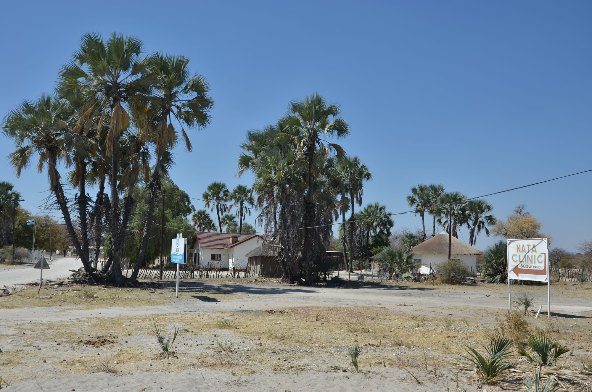
Tall palms and low houses beside a sandy road in Nata, with a hand-painted sign pointing to the village clinic

Francistown & the Central District, Botswana

Nata

Palms, houses and a clinic sign beside the sand road in Nata. (Pavel Špindler / Wikimedia Commons · CC BY 3.0)

A village in Botswana's Central District at the junction where the roads from Francistown, Maun and Kasane meet, near the northern edge of Sua Pan. Built around water from the Nata river and cattle country, it lives largely off passing traffic, fuel and food for travellers, and a community-run bird sanctuary on the pan south of the village.

Neighbourhoods

  • The junction
    • First-time visitors
    • Fuel and supplies
    • Close to transport

    Where the Francistown, Maun and Kasane roads meet, and where almost every vehicle in this part of the country stops. Filling stations, a shop or two, takeaways and the buses and minibuses that link the three directions are all within a few minutes' walk of the corner.

    Open in Maps
  • The village
    • Local life
    • Quiet and residential

    Sandy tracks lead off the tar between fenced compounds of block houses and thatched rondavels shaded by palms and mophane. The clinic, the schools and the kgotla are here, and the pace is slow except at dawn and dusk when the livestock move.

    Open in Maps
  • The sanctuary road
    • Birdwatching
    • Quiet
    • Sunsets

    South of the village the road runs towards the Nata river mouth and the edge of Sua Pan, past grassland, palm clumps and a few lodges and campsites. It is flat, open country that ends at the pan itself, and the reason most visitors stay a night rather than driving on.

    Open in Maps

Things to do

The pan and the river

  • Nata Bird Sanctuarypark

    A community-run reserve on the north-eastern corner of Sua Pan, about 15 km south of the village, where flamingos, pelicans and waders gather in numbers when the pan floods after the rains.

    Open in Maps
  • Nata Riverattraction

    The seasonal river that rises in Zimbabwe and ends in Sua Pan beside the village, filling the pan's northern edge in a good wet season and drawing birds and game to its mouth.

    Open in Maps
  • Sua Panattraction

    The easternmost of the three great Makgadikgadi pans, a huge flat sheet of salt and clay that holds shallow water and flamingos in wet years and is blinding white in the dry.

    Open in Maps

Short trips from the village

  • Kubu Islandlandmark

    A granite outcrop rising from the salt, the whole island a national monument and a sacred site, with dry stone walling, hundreds of stone cairns and a basic campsite run for the local community.

    Open in Maps
  • The soda-ash works at Sua Panattraction

    The soda-ash and salt works that draw brine from beneath Sua Pan, producing several hundred thousand tonnes of each a year, with the planned township of Sowa, established in 1991, built beside them.

    Open in Maps

Eat and drink

Long-standing places and food districts in Nata. Hours, ratings and directions come from your maps app, always current.

Eating at the junction

  • Takeaways and stalls at the junctionneighborhood

    The places clustered at the crossroads sell grilled and stewed meat with pap, fat cakes, chips and cold drinks to bus passengers and truck drivers, and are the practical option for anyone passing through.

    Open in Maps
  • Shops and bottle storesmarket

    General dealers stock maize meal, sorghum, bread, tinned goods and beer for the village and for self-drivers loading up before the long empty roads west to Maun or north to Kasane.

    Open in Maps

Lodge kitchens

  • Lodges on the sanctuary roadrestaurant

    The lodges and campsites south of the village cook set meals for guests — braaied meat, stews, salads and breakfasts — and are where most overnight visitors eat.

    Open in Maps

Experience Nata

History

Nata owes its existence to water and to routes. The Nata river, seasonal but reliable in a wet year, reaches Sua Pan here, and the grassland around its mouth made good grazing in a country where surface water is rare. Bakalanga and Batswana cattle-keeping families settled along it, and the pans behind the village were known long before as a source of salt and a hunting ground, crossed on the old wagon routes that ran north-west from the Tati gold fields towards Ngamiland and the Zambezi.

The modern village is a creature of the road. As tarred highways were pushed through northern Botswana in the later twentieth century, the point where the routes from Francistown, Maun and Kasane converged became the natural place to stop, refuel and change buses. Filling stations, shops and lodges followed, and Nata grew into a service village for a very large and thinly settled area.

Two later developments shaped it further. The soda-ash and salt works on the north-eastern side of Sua Pan, with its own planned town, brought industry and jobs to the pan in the 1990s, and a heavy-truck trade to the roads. Planned from 1988 by local communities and opened in 1993, the Nata Bird Sanctuary on the pan's north-eastern corner was one of Botswana's earliest community-run conservation projects, turning the floodwaters and their flamingos into a reason for travellers to stay the night rather than simply pass through.

Culture & Customs

Nata sits on a cultural boundary. It lies in the Central District among Bangwato villages, but Kalanga families from the north-east and Bakalanga, Babirwa and San communities from around the pans all live here, and Ikalanga is heard alongside Setswana and the English of the road. Traffic from three directions has made the village unusually mixed for its size, with Zimbabwean traders and travellers a constant presence.

Village life follows the familiar rural pattern: the kgotla for meetings and disputes, churches of several denominations, and weddings and funerals that fill a compound for days and draw relatives from Francistown, Gaborone and beyond. Cattle are the measure of a family's standing, and the calendar turns on the rains, the ploughing and the mophane harvest rather than on any festival.

The bird sanctuary has become part of local identity as well as local income: it was set up by the surrounding communities, who gave up grazing on the pan edge in exchange for a share in it, and the argument about how conservation, cattle and livelihoods fit together is an ongoing local conversation rather than a settled matter. Visitors are met with straightforward courtesy; greetings come first, and photographs of people should be asked for.

Daily Life

About 7,700 people live in Nata, making it a large village by the standards of this empty stretch of country. The day starts early, slows in the heat and picks up again as the light softens, when cattle, goats and donkeys drift back through the sand tracks between the compounds.

Work comes from the road and from livestock. Filling stations, shops, takeaways, lodges and campsites live off the traffic between Francistown, Maun and Kasane; the sanctuary and the tourism around it employ guides, cooks and cleaners; the soda-ash works on the pan draws workers from the whole area, and a few commute to Francistown. Most households also keep cattle and goats at the lands and cattle posts outside the village, and plant sorghum, maize and melons when the rains allow.

Services are those of a village rather than a town: a clinic, primary and secondary schools, boreholes and standpipes, mobile coverage that fades quickly beyond the settlement. Elephants moving along the Nata–Kasane road are a routine hazard and sometimes reach fields and water points. Drought, the price of cattle and the reliability of the borehole supply are the recurring worries, and serious shopping, banking and hospital care mean a trip to Francistown.

Food

Everyday cooking here is the plain fare of rural Botswana: bogobe, a porridge of sorghum or maize meal, served with beef, goat or chicken stew, with morogo — gathered or cultivated greens — or with dikgobe, samp and beans simmered together. Seswaa, meat boiled long and pounded soft with salt, belongs to weddings, funerals and kgotla occasions rather than to daily meals.

Phane, the fat caterpillars of the mophane emperor moth, are collected in the surrounding woodland after the rains, gutted, boiled and dried, then fried with onion and tomato or eaten dry as a snack; the harvest brings cash as well as protein to village households, and sacks of them travel from here to the markets of Francistown. Madila, soured milk from the cattle posts, and biltong carry households through the dry months, and marula and baobab fruit are eaten and drunk in season.

The junction itself has its own food culture, shaped by drivers and bus passengers: grilled meat, fat cakes, roasted maize, chips and sweet tea sold quickly and eaten standing up. Bottle stores supply lager, Chibuku sorghum beer and home brews, while the lodges south of the village cook braais and international dishes for their guests.

Planning tools

Budget

Nata is one of the cheaper places to break a journey in northern Botswana. Village rooms, campsites and roadside food cost little, and buses along the three main roads are inexpensive. Costs rise with sanctuary entry, a guided birding or pan trip, or a 4x4 expedition out to Kubu Island, and fuel is a major item for anyone driving the long distances between towns here.

Daily Budget Midrange
USD 130–320 (a lodge on the sanctuary road, a share of 4x4 hire, sanctuary fees and a guided pan or birding trip)
Daily Budget Shoestring
USD 35–70 (a campsite or village guesthouse, food from the junction, buses along the main roads)

Camping at or near the sanctuary is the cheapest way to see the pan, and fuel should be topped up here, since the next stations towards Maun and Kasane are far apart.

Best Time to Visit

The pan holds water from the rains until about April or May, and that is when the flamingos, pelicans and waders gather, making the sanctuary worth a stay in its own right. May to October is dry, cooler and easier for driving on the pan and out to Kubu Island, with far fewer birds. September and October are dry and very hot.

Suggested Number of Days

Most travellers stop for a single night between Francistown, Maun and Kasane. Two or three days suit birdwatching at the pan or a 4x4 trip further out onto the salt. Water levels and road conditions, rather than the number of sights, decide how long is worthwhile.

First Visit
1 night
With Surroundings
2–3 days

Transportation

The village is small enough to walk, and donkey carts are still in everyday use. Buses and minibuses running between Francistown, Maun and Kasane stop at the junction, which makes Nata one of the easier places in the region to change direction without a car. The sanctuary and everything off the tar need a vehicle, and the pan tracks need a 4x4 with high clearance.

Hitching a lift at the junction is common practice locally, and long-distance buses fill up, so travelling early in the day gives the best chance of a seat.

Airport & Station Connections

Nata stands at the meeting of three tarred roads: Francistown lies about 190 km to the south-east, Maun roughly 300 km west, and Kasane about 300 km north. Each is a drive of three to four hours, and buses and minibuses cover all three routes daily. The nearest airports with scheduled flights are Francistown, Maun and Kasane.

Walkability

Flat and compact: the junction, the shops and much of the village are within a twenty-minute walk, on sand rather than pavement once off the tar. Heat and glare are the main difficulty in the middle of the day, and there is little shade. The sanctuary is too far to walk to, and walking on the main roads after dark is unsafe because of traffic and livestock.

Safety

The village is quiet and crime against visitors is uncommon, though normal care with luggage at a busy road junction applies. The serious risks are on the roads and the pan: trucks, cattle, donkeys and elephants on the tar after dark, fierce heat and glare, and the danger of breaking through the salt crust or losing the track far from any mobile signal.

Drive only in daylight, carry extra water and recovery gear onto the pans, and tell someone the route. Check current official travel advice before travelling.

Climate

Hot and semi-arid, with thunderstorm rains from about November to March and a long dry season from April to October. Southern-hemisphere summer falls in December to February. The pan holds water only after good rains, and winter nights on the open flats are cold.

Summer
hot, roughly 32–40°C by day, humid after storms, with green grass and water on the pan
Winter
dry and clear, about 22–27°C by day, with cold nights and strong glare off the salt

Local Customs

Rural Setswana courtesy governs everyday dealings: greet before asking — dumela mma or dumela rra — address elders first, and expect an unhurried exchange rather than a quick transaction. Dress is modest, the kgotla is a working institution rather than an attraction, and people's homes, cattle and compounds are private. Permission should be asked before photographing anyone.

Tipping is not obligatory but is usual for guides and lodge staff; alcohol is sold through bottle stores under restricted hours, and public drinking is frowned on.

Common Payment Methods

The currency is the Botswana pula. Cash is needed for stalls, fares and small shops, and card acceptance in the village is limited, so pula should be carried in; banking facilities are far better in Francistown, Maun or Kasane. Filling stations and lodges are the most likely places to take cards, and lodges may quote in US dollars.