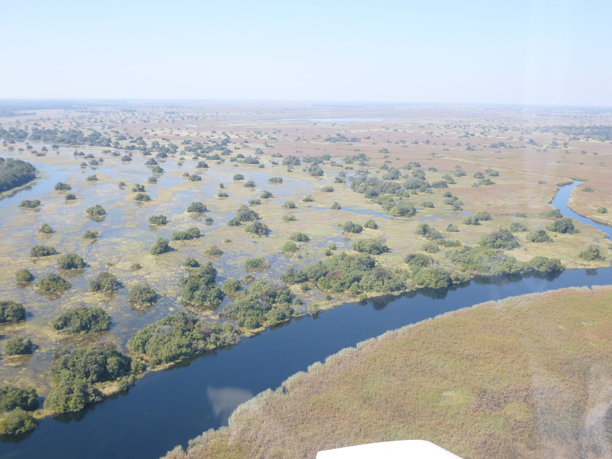
Aerial view of a wide river curving through flooded grassland dotted with dark clumps of trees and open water

The Okavango Delta, Chobe & the North, Botswana

Seronga

The Okavango near Seronga, where the panhandle channel begins to spread into the delta. (~ souTH AFRica ~ / Wikimedia Commons · CC BY 3.0)

A village on the eastern bank of the Okavango at the head of the panhandle, where the river leaves its single channel and begins to spread into the delta. Cut off from the main road network by the water, it is reached by a crossing at Mohembo or by air, and is known as a starting point for community-run mokoro trips.

Neighbourhoods

  • The village centre
    • First-time visitors
    • Local life
    • Shops and services

    A spread of homesteads, small shops, a clinic, schools and government offices along sand tracks set back from the river. Cattle, goats and donkey carts share the roads, and the pace is unhurried outside the early morning.

    Open in Maps
  • The riverside and the boat landings
    • Mokoro and boat trips
    • Fishing
    • Birdwatching

    The edge of the village where the ground falls to reeds, papyrus and open water, and where mokoro and motorboats set out. Hippos and crocodiles use the same channels, so the banks are treated with respect.

    Open in Maps
  • The road east
    • Quiet and residential
    • Wildlife

    Sand tracks run east from the village towards the smaller settlements along the delta's northern edge, through mopane and palm country. Elephants move through this ground, and travel beyond the village needs a high-clearance vehicle.

    Open in Maps

Things to do

The delta and the river

  • The Okavango Deltaattraction

    The inland delta where the Okavango fans out into channels, lagoons and palm islands, a UNESCO World Heritage Site, and the water that mokoro trips from the village enter directly.

    Open in Maps
  • The Okavango panhandleattraction

    The narrow, deep stretch of river above the delta, lined with papyrus and reed, known for bream and tigerfish angling and for large numbers of waterbirds.

    Open in Maps

Getting in and out

  • Seronga Airporttransit hub

    The village airstrip, used by the light aircraft that connect this side of the delta with Maun and the camps.

    Open in Maps

Short trips from the village

  • Moremi Game Reservepark

    The protected eastern heart of the Okavango, proclaimed a reserve in 1963 and named after Chief Moremi III of the Batawana, with lion, leopard, wild dog and buffalo on its islands and floodplains.

    Open in Maps

Eat and drink

Long-standing places and food districts in Seronga. Hours, ratings and directions come from your maps app, always current.

Where people eat in Seronga

  • The village shopsneighborhood

    Small general dealers and takeaway counters sell bread, maize meal, tinned goods, grilled meat and chips; supplies arrive across the river, so the choice is narrower than in the bigger panhandle villages.

    Open in Maps
  • River fishneighborhood

    Bream (tilapia) and catfish caught from the channels are the everyday protein, fried, grilled over coals or dried in the sun to keep, and are what camps here serve as well.

    Open in Maps
  • Home cooking and the campsneighborhood

    Most eating is at home or at the camps by the water — bogobe or pap with stew and greens in the village, and a simple set menu, often around a fire, for visitors on mokoro trips.

    Open in Maps

Experience Seronga

History

The northern side of the delta has one of the longest records of settlement in Botswana. San communities hunted and gathered along these floodplains for thousands of years, and river peoples moved in later, drawn by year-round water, fish and grazing on ground that the Kalahari otherwise denies. Seronga grew where firm land meets the head of the panhandle, at the point where the single channel begins to break up, which made it both a crossing place and a natural harbour for dugouts.

The Bayei are the community most associated with the delta's waterways. They came south from the Zambezi region and are credited with bringing the mokoro, the dugout canoe poled through shallow channels, into the Okavango, along with fish traps and floodplain farming; the Hambukushu of the panhandle are their northern neighbours, and both were drawn into the Batawana state centred on Lake Ngami from the late eighteenth century. Colonial administration touched this bank lightly: with no bridge and no tarred road, it stayed at the far edge of the Bechuanaland Protectorate.

The modern history is one of slowly easing isolation. Veterinary fences, tsetse-fly control and the ferry at Mohembo shaped movement for decades; the Okavango Delta's listing as a UNESCO World Heritage Site in 2014 raised its profile; and community tourism gave the village a new source of income, with local polers organising trips into the delta rather than working only for outside operators. A bridge over the river at Mohembo has since replaced the ferry.

Culture & Customs

Seronga is a delta village, and its culture is built on water. The Bayei tradition of poling a mokoro, reading channels, setting fish traps and farming the floodplain runs through daily life, alongside Hambukushu and San families and a Tswana administrative layer. Several languages are in use — Setswana as the national language, English in offices and schools, Thimbukushu and the Bayei language at home — and most people move between them.

Community organisation matters here more than in most places. The kgotla remains where matters are discussed and settled, and mokoro trips into the delta are arranged collectively by local polers, men and women from the village who take visitors out and share the income. That arrangement has made guiding, poling and knowledge of animals and channels a respected form of work, and it shapes how the village deals with outsiders: trips are arranged collectively rather than touted.

Churches draw large congregations, and funerals and weddings pull families back from Maun and Gaborone. Craft follows the river as well, with palm-fibre baskets, mats, fish traps and carved paddles made in the villages along this bank. Wildlife is part of the social fabric rather than a spectacle: elephants in the fields and hippos in the channels are a standing subject of conversation and of complaint.

Daily Life

About 2,800 people live in Seronga village, and some 3,300 with the settlements around it, in homesteads of brick, mud and thatch spread under palms and mopane along sand tracks. The village has a clinic, schools, a police presence and small shops, and serves as a minor centre for the scatter of settlements along the delta's northern edge, most of which are smaller still. Supplies arrive across the river or over long sand roads, so prices are higher and choice narrower than in the panhandle towns.

People live from fishing, floodplain fields of maize, sorghum and millet, cattle and goats, basket weaving, government jobs and tourism. Mokoro trips, camps and guiding bring in money that is unusual in a village of this size, and remittances from relatives in Maun and further afield make up much of the rest. Work is seasonal: the dry months bring visitors, the rains bring farming and quiet.

The rhythm follows the heat and the water. Boats and polers leave early, the middle of the day is still, and activity picks up again in the late afternoon. Local concerns are constant and practical: the state of the roads and the crossing, elephants raiding fields, the flood's height, access to health care at a distance, and how much of the tourism income stays in the community.

Food

Everyday meals are Botswana's, adapted to the river. Bogobe, a porridge of sorghum, millet or maize, is the base, eaten with a relish of beef, goat or chicken, morogo (cooked wild greens), or beans and samp. Seswaa — meat boiled long and pounded with salt — is made for weddings, funerals and kgotla occasions, and meat grilled over coals is the shared, sociable meal.

Fish carries the rest of the diet. Bream, the local name for tilapia, and catfish are caught by line, net and trap in the channels and lagoons, then fried, grilled or split and dried in the sun so they last into the following season. Water-lily tubers and seeds are gathered from the floodplain, and wild fruits such as marula, monkey orange and palm fruit are eaten in season, some also fermented.

Phane, the dried mophane caterpillars, are collected in the woodland and fried with onion and tomato or eaten dry as a snack. Maize and sorghum are pounded at home or milled in the village. Tea, bottled lager, Chibuku sorghum beer and home brews are the usual drinks, and food on a mokoro trip is simple camp cooking, often with fish from the water being crossed.

Planning tools

Budget

Seronga is among the cheapest ways into the Okavango, because trips start from the village rather than from a charter flight. Community-run mokoro excursions, camping and self-catering keep costs low, and prices are in pula. Getting here — a hired vehicle, the crossing at Mohembo, or a light aircraft — is usually the largest single cost.

Daily Budget Midrange
USD 250–630 (a camp by the water, a multi-day guided mokoro and walking trip, transfers or a flight in)
Daily Budget Shoestring
USD 45–95 (camping or a basic room, food from the village shops, a shared mokoro trip with a poler)

Bring enough pula cash for the whole stay, and food if self-catering: banking and supplies are limited on this side of the river.

Best Time to Visit

May to October is dry, clear and comfortable, with the flood from Angola at its highest and the channels easiest to pole; this is the main season for mokoro trips. September and October are very hot, often above 40°C. The rains from about November to March bring migrant birds, green country, higher malaria risk and difficult sand roads.

Suggested Number of Days

Two or three days allow the village and a trip onto the water, including an overnight on an island. Four or five suit a longer guided excursion or slower travel in a corner of the country where journeys take most of a day.

First Visit
2–3 days
With Surroundings
4–5 days

Transportation

There is no tarred road to Seronga. Travel within the village is on foot, by donkey cart or by 4x4 on sand tracks, and travel beyond it is by boat, by light aircraft from the airstrip, or by the long sand route around the delta's northern edge. On the water, mokoro poled by local guides and motorboats do the work.

Sand tracks here need a 4x4 and experience, and fuel, spares and recovery help are scarce once the village is left behind.

Airport & Station Connections

Most visitors reach Seronga from the west bank of the Okavango, crossing the river near Mohembo, about 90 kilometres to the north-west, and continuing by road, or coming in by boat down the panhandle from Sepopa. Light aircraft from Maun use the village airstrip. The overland route around the delta from Maun is long, sandy and slow.

Walkability

The village is flat and walking is the normal way to get around it, though homesteads are spread out along sand tracks, there is little shade at midday and few pavements or street lights. Walking near the water or after dark carries real risk from hippos, crocodiles and elephants, so local advice matters.

Safety

Botswana is one of the safer countries in Africa for visitors, with a stable government and low levels of violent crime; towns have ordinary urban theft that sensible precautions handle. At Seronga the dangers are environmental: hippos and crocodiles in the channels, elephants around the village, malaria, heat, and a long way to a hospital.

Take malaria precautions, follow the poler's instructions exactly in a mokoro, keep well back from the water's edge and from elephants, and carry medical-evacuation insurance. Check current official travel advice before travelling.

Climate

Hot and semi-arid, with summer rains from about November to March and a long dry season. Being in the southern hemisphere, summer falls in December to February and winter in June to August. October is the hottest month, just before the rains, and the delta's flood peaks in the dry winter months.

Summer
hot and humid, often 33–40°C by day, with afternoon thunderstorms and dispersed game
Winter
dry and clear, around 25–30°C by day, with cold mornings of about 5–10°C on the water

Local Customs

Greetings come before anything else, and Setswana, Thimbukushu and the Bayei language are heard alongside English. Dress is modest by village standards, and photography of people or homesteads is asked about first. Polers and guides are usually local men and women from the community, and tipping at the end of a trip is customary.

Ask before photographing people or homesteads, agree what a trip includes before setting out, and treat a poler's instructions about hippos and crocodiles as rules rather than suggestions.

Common Payment Methods

The currency is the Botswana pula (BWP). Banking is minimal on this side of the river, cards are rarely useful and mobile coverage can be patchy, so cash brought from Maun, Shakawe or Gumare covers trips, shops, fuel and tips. Larger safari operators may quote in US dollars.