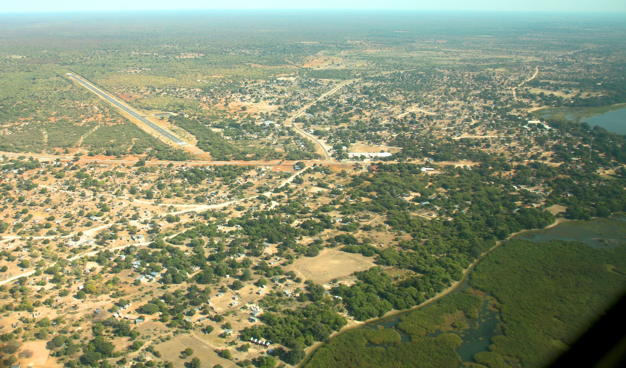
Aerial view of a low village spread through bush and sand tracks, with a single airstrip on the left and green river channels on the right

The Okavango Delta, Chobe & the North, Botswana

Shakawe

Shakawe from the air, with its airstrip and the reed channels of the Okavango panhandle on the right. (Hp.Baumeler / Wikimedia Commons · CC BY-SA 4.0)

A large village on the Okavango panhandle in Botswana's far north-west, close to the Namibian border, where the river runs in a single deep channel before fanning out into the delta. It is the main service centre for the upper panhandle, a base for fishing and birding, and the road town nearest the Tsodilo Hills.

Neighbourhoods

  • The centre and the main road
    • First-time visitors
    • Shops and services
    • Local life

    The village strings along the tarred road that ends at the border, with shops, a filling station, a bank, the clinic, schools and government offices grouped near the middle. Sand tracks run off it to homesteads under mango and marula trees.

    Open in Maps
  • The riverside
    • Fishing
    • Birdwatching
    • Quiet

    East of the road the ground falls to the Okavango, where reed beds, papyrus and a deep channel edge the village. Boats, camps and fishing spots are reached down sandy tracks, and the water is busy at dawn and dusk with birds, hippos and crocodiles.

    Open in Maps
  • Towards Mohembo
    • Border crossing
    • Close to transport

    The road north follows the river to the Mohembo border post with Namibia, a short way north, past small settlements and fields. The bridge over the Okavango here carries the route to the delta's eastern bank.

    Open in Maps

Things to do

The river

  • The Okavango panhandleattraction

    The narrow, deep stretch of the Okavango above the delta, hemmed by papyrus and reed, known for tigerfish and bream angling and for the birdlife of the delta, where more than 400 species have been recorded.

    Open in Maps
  • Shakawe Airporttransit hub

    The village airstrip, used by light aircraft serving the panhandle camps and the settlements of the north-west.

    Open in Maps

Short trips from the village

  • Tsodilo Hillslandmark

    Four hills rising from the Kalahari, holding thousands of rock paintings and listed as a UNESCO World Heritage Site in 2001, of great spiritual significance to the San peoples of the Kalahari.

    Open in Maps
  • Bwabwata National Parkpark

    The Namibian park along the Caprivi strip, reached across the border north of the village, whose western section on the Okavango is known for elephant, sable and roan antelope.

    Open in Maps

Eat and drink

Long-standing places and food districts in Shakawe. Hours, ratings and directions come from your maps app, always current.

Where people eat in Shakawe

  • The village shops and takeawaysneighborhood

    Small general dealers, bakeries and takeaway counters along the main road sell bread, grilled meat, chips and the everyday plate of bogobe or pap with stew, mostly to people travelling the panhandle road.

    Open in Maps
  • Supermarkets and stallsmarket

    The village is the last place with proper shops before the Namibian border and the delta's edge, so self-drive travellers stock up here; stalls sell fruit, vegetables and seasonal wild foods.

    Open in Maps
  • River fishneighborhood

    Bream (tilapia) and catfish from the panhandle are the local protein, fried, grilled over coals or dried for later, and are served in the riverside camps as well as at home.

    Open in Maps

Experience Shakawe

History

The panhandle has been lived in for far longer than most of Botswana. San communities have been in this corner of the Kalahari for many thousands of years, as the painted hills at Tsodilo to the south-east record, and river-dwelling farming peoples settled along the Okavango well over a thousand years ago, fishing, growing millet and sorghum on the floodplain and keeping small stock. Shakawe grew as one of the villages where the deep channel, firm ground and fields came together.

The Hambukushu are the people most associated with the upper panhandle. They came south from the Zambezi and Kwando region over several centuries, bringing iron working, river farming and a reputation as rainmakers, and they settled the riverbank villages under their own leaders while acknowledging the Batawana state centred far to the south around Lake Ngami. Trade in ivory, hides, fish and grain tied the river villages to the wider region long before colonial administration reached them.

In the twentieth century the village remained remote, hemmed by sand roads, the tsetse fly and veterinary fences. A further wave of Hambukushu arrived from Angola from the late 1960s as war crossed the border, and were settled in the panhandle and at Etsha. Tarring the road from Maun, the growth of the fishing and safari trade, Tsodilo's World Heritage listing in 2001 and the bridge over the Okavango at Mohembo have steadily reduced the isolation, and Shakawe is now the service centre for the whole upper panhandle.

Culture & Customs

Shakawe's culture is river culture. The Hambukushu form the majority, with Thimbukushu spoken at home, Setswana as the national language and English in offices and schools, alongside Bayei, Herero, San and Tswana families and Namibians with kin on the far bank. Fishing, poling a dugout and reading the flood are ordinary skills here rather than tourist attractions, and knowledge of the channels is something older people hold and pass on.

Craft is the best-known cultural export. Women across the panhandle weave tightly coiled baskets from the fibre of the mokola palm, dyed with bark and roots into patterns with their own names, and sell them through village cooperatives that reach shops in Maun and beyond. Wood carving, fish traps and reed work belong to the same tradition of using what the river provides.

Community life runs through the kgotla, where matters are discussed until a decision is reached, and through the churches, which draw large congregations on Sunday. Rain and the flood carry particular weight in local belief and conversation: the Hambukushu have a long association with rainmaking, and the Tsodilo Hills to the south-east are treated as a place of spiritual significance rather than a viewpoint. Visitors are expected to behave accordingly.

Daily Life

About 7,000 people live in Shakawe, which makes it one of the larger villages of the north-west and the place where the surrounding settlements come for anything official. Homesteads of brick and thatch spread through the bush on sand tracks, with cattle, goats and donkeys wandering between them, and the tarred road carries the shops, the filling station, the bank, the clinic, the schools and the government offices.

People live from a mixture of things: fishing the panhandle, growing maize, sorghum and millet on floodplain fields, keeping livestock, weaving baskets, and paid work in government, schools, the border post and the camps and lodges along the river. Money from relatives working in Maun, Gaborone or South Africa matters too. Unemployment is high, as it is across rural Botswana, and young people often leave for the towns.

The day begins early, before the heat, and slows through the middle hours. Water levels, crop damage by elephants and hippos, school results and the state of the sand roads are constant subjects. Electricity, mobile coverage and the tarred road have all reached the village, but distance still shapes everything: Maun is most of a day away, and serious medical cases travel far.

Food

Food here is Botswana's, with the river added. Bogobe, a porridge of sorghum or maize, is the base of most meals, eaten with a relish of beef, goat or chicken, morogo (cooked wild greens), or beans and samp. Seswaa — meat boiled long and pounded with salt — is cooked for weddings, funerals and kgotla occasions, and grilled meat over coals is the social meal.

Fish is what distinguishes panhandle cooking. Bream, the local name for tilapia, and catfish are taken by line, net and trap from the channels, then fried, grilled or split and dried in the sun so they keep through the year. Tigerfish, the prize of visiting anglers, are largely caught and released. The floodplain also yields water-lily tubers and seeds, and wild fruits including marula and monkey orange are gathered in season.

Phane, the dried mophane caterpillars, are collected in the surrounding woodland and fried with onion and tomato or eaten as a snack. Millet and sorghum are ground at home or at small mills. Drinks are tea, bottled lager, Chibuku sorghum beer and home brews, and the riverside camps cook a more international menu for their guests, usually with fish from the same water.

Planning tools

Budget

Shakawe is one of the cheapest entries to the Okavango, because the river is at the village rather than an hour's flight away. Camping, self-catering and shared boat trips keep daily costs low; riverside camps, guided fishing and a vehicle to the Tsodilo Hills raise them. Most costs here are in pula rather than dollars, unlike the fly-in delta camps.

Daily Budget Midrange
USD 250–630 (a riverside camp, guided fishing or birding by boat, a hired vehicle for the Tsodilo road)
Daily Budget Shoestring
USD 45–95 (a campsite or simple room, supermarket food, a shared boat or a lift to the hills)

Fuel, cash and supplies are easier to find here than anywhere further along the panhandle, so it is worth sorting all three in the village.

Best Time to Visit

May to October is dry, clear and comfortable, with the panhandle's water high from the Angolan flood and good fishing and birding. September and October are very hot, with highs approaching 40°C. The rains from about November to March bring migrant birds, green country and a higher malaria risk, and sand roads can become difficult.

Suggested Number of Days

A day or two covers the village and a trip on the river. Three or four suit anyone adding the sights further out, more time on the water, and the slow travel that sand roads impose in this corner of the country.

First Visit
1–2 days
With Surroundings
3–4 days

Transportation

Everything in the village is on or just off one tarred road, and people walk, use minibuses along the panhandle route, or drive. Beyond the tar, tracks are deep sand and need a 4x4 with reasonable clearance, including the road to the Tsodilo Hills. Boats do much of the local travelling on the river itself.

Carry enough fuel and water for side trips: filling stations and workshops are scarce beyond the village.

Airport & Station Connections

A tarred road runs north from Maun through Gumare and Sepopa to Shakawe, about five hours by bus, and minibuses work the route. The village airstrip takes light aircraft from Maun. The Mohembo border post with Namibia lies a short way north, on the route to the Caprivi and Rundu, and a bridge built in 2022 carries the road over the Okavango there.

Walkability

The village is flat and walkable, though it is spread out along several kilometres of road and sand tracks, with little shade at midday and few pavements. Walking is normal by day; after dark, unlit roads, traffic and the occasional hippo or elephant near the river make a vehicle or a torch and company sensible.

Safety

Botswana is one of the safer countries in Africa for visitors, with a stable government and low levels of violent crime; towns have ordinary urban theft that sensible precautions handle. Around Shakawe the real dangers are environmental: hippos and crocodiles in the river, elephants on the roads and in fields, malaria, heat, and long distances from medical help.

Take malaria precautions, keep well back from the water's edge and from elephants, follow guides' instructions on a boat or in a mokoro, and avoid driving the panhandle road at night. Check current official travel advice before travelling.

Climate

Hot and semi-arid, with summer rains from about November to March and a long dry season. Being in the southern hemisphere, summer falls in December to February and winter in June to August. October, before the rains break, is the hottest month; the river's own flood from Angola arrives in the dry season.

Summer
hot and humid, often 33–38°C by day, with afternoon thunderstorms and green bush
Winter
dry and clear, around 25–30°C by day, with cold mornings of about 5–10°C

Local Customs

This is a Hambukushu area, and Thimbukushu is widely spoken alongside Setswana and English. Greetings come before business, and an unhurried handshake is normal. Dress is modest by village standards. Basket weaving is a serious local craft, sold through cooperatives, and bargaining hard over it is not the custom.

Ask before photographing people, homesteads or the border post, and treat the Tsodilo Hills as a sacred place: stay with a guide and do not touch the paintings.

Common Payment Methods

The currency is the Botswana pula (BWP). There is a bank and at least one ATM in the village, and cards work at the larger shops and the filling station, but machines can be out of service and connections unreliable. Cash is needed for stalls, baskets, small shops and tips, and should be carried when heading further into the panhandle.