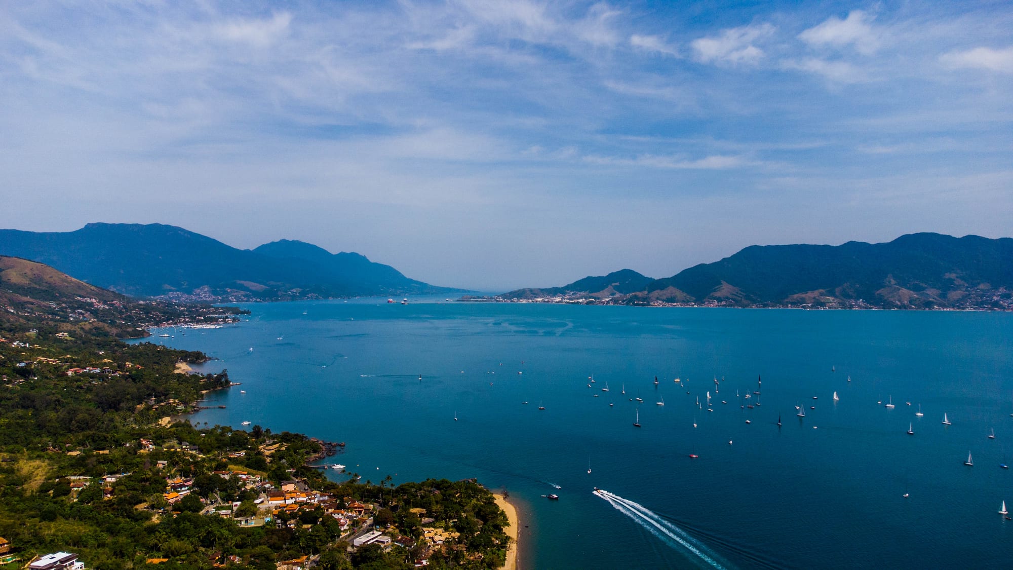
An aerial view over a wooded shore with houses and a small beach, sailing boats on a blue channel and mountains beyond

São Paulo, Brazil

Ilhabela

The São Sebastião channel between Ilhabela and the mainland, seen from the air. (João D'Andretta / Wikimedia Commons · CC BY-SA 4.0)

An island municipality off the north coast of São Paulo state, reached by a short ferry from São Sebastião. Its main island of mountains and Atlantic Forest, mostly protected as a state park, once grew sugar and coffee and built canoes; today its sheltered western shore of beaches and sailing waters draws weekenders, while the ocean side stays wild.

Neighbourhoods

  • Vila
    • Historic district
    • Restaurants
    • First-time visitors

    The island's old centre, which grew around the chapel of Nossa Senhora D'Ajuda and became the village of Vila Bela da Princesa in 1805. Its small streets hold restaurants, shops and inns, facing the channel.

    Open in Maps
  • Perequê
    • Close to the ferry
    • Shops
    • Local life

    The busy commercial district near the ferry landing, where most residents shop and many of the island's practical services, restaurants and cheaper places to stay are found along the main avenue.

    Open in Maps
  • The north-west beaches
    • Beaches
    • Sailing
    • Families

    A string of sheltered beaches along the road north of the ferry — Barreiros, Siriúba, Pedra do Sino, Armação — with calm water suited to swimming, windsurfing and kitesurfing, kiosks and holiday houses.

    Open in Maps
  • Castelhanos and the ocean side
    • Beaches
    • Hiking
    • Caiçara villages

    The wild eastern and southern coasts facing the open Atlantic, where small caiçara communities live in bays reached by an unpaved road over the mountains to Castelhanos, by long trails such as the one to Bonete, or by boat.

    Open in Maps

Things to do

Forest, trails and waterfalls

  • Ilhabela State Parkpark

    The state park created in 1977 that protects most of the archipelago — mountains rising above 1,000 metres, Atlantic Forest and hundreds of waterfalls, crossed by trails of every difficulty.

    Open in Maps
  • Água Branca waterfallstrail

    Waterfalls and pools at the park entrance on the way to Castelhanos, with a bird-watching tower.

    Open in Maps
  • Bonete trailtrail

    A trail of about 12 km through the state park from Ponta da Sepituba to the remote caiçara village and surf beach of Bonete, passing three waterfalls.

    Open in Maps

Beaches

  • Praia de Castelhanosbeach

    The great bay on the ocean side, the only beach there reachable by road — an unpaved track over the mountains with one-way traffic controlled by park staff.

    Open in Maps
  • Praia da Pedra do Sinobeach

    A beach on the north-west shore named after its rocks, which make a bell-like sound when they strike each other.

    Open in Maps
  • Praia do Bonetebeach

    A beach with strong surf in front of a village of about 300 people at the south of the island, reached on foot or by boat.

    Open in Maps

The sea

  • Wreck of the Príncipe de Asturiasattraction

    The Spanish liner that ran aground in fog off Ponta do Boi in March 1916 with the loss of at least 445 lives — the best known of more than fifty wrecks around the archipelago, six of them open to divers.

    Open in Maps

Short trips from the island

  • São Sebastiãoattraction

    The mainland town across the channel, reached by the ferry, a colonial port of the gold era with its own historic centre and beaches.

    Open in Maps

Eat and drink

Long-standing places and food districts in Ilhabela. Hours, ratings and directions come from your maps app, always current.

Ilhabela classics

  • Restaurants in the Vilaneighborhood

    The old centre's cluster of restaurants, where moqueca, grilled fish and bobó de camarão are standard.

    Open in Maps
  • Perequêneighborhood

    Everyday restaurants and per-kilo lunch places on the main avenue near the ferry, used by residents as much as visitors, several specialising in seafood.

    Open in Maps
  • Castelhanos beach kiosksneighborhood

    Simple caiçara kitchens on the ocean-side beach serving fried fish and seafood to the day-trippers who make the drive over the mountains.

    Open in Maps

Experience Ilhabela

History

For at least 2,000 years before the Portuguese arrived, the archipelago was home to shell-mound peoples, followed by ceramic-making groups and then by Tupi-Guarani and Jê peoples, who knew the main island as Maembipe. An expedition including Amerigo Vespucci reached it on 20 January 1502; the main island is officially named Ilha de São Sebastião. Through the 16th and 17th centuries English, French and Dutch pirates sheltered in its bays; Thomas Cavendish came in the late 16th century, and the raids left legends of buried treasure.

Land grants began in 1603, and sugar cane spread over the slopes facing the mainland. Slave ships used the channel, and some enslaved Africans escaped to found quilombos in the forest. In the 18th century the first whaling station of the captaincy of São Paulo operated on the island until the whales grew scarce around 1850. In 1805 the island became the village of Vila Bela da Princesa. Coffee replaced sugar in the 19th century: in 1854 the island had about 10,800 inhabitants and 225 farms worked by more than 1,700 enslaved people. After abolition the island turned to distilling cane spirit, shipped to Santos in vogas, large sailing canoes built from its forest trees.

Japanese immigrants arrived in the 1920s and modernised fishing. The economic crisis of the 1930s hit hard; the municipality was briefly abolished and then renamed, taking the name Ilhabela in 1945. Tourism grew from the 1960s, bringing real-estate pressure on the forest, and in 1977 most of the archipelago became a state park.

Culture & Customs

The caiçara tradition is the island's backbone. Fishing families of mixed Indigenous, African and Portuguese descent built the vogas and canoes, fished the channel and the open sea, and still live in small communities on the ocean side — at Castelhanos, Bonete and on the outlying islands of Búzios and Vitória, which in recent counts had 142 and 50 inhabitants. Handicrafts and fishing remain part of local life alongside tourism.

The sea defines the island's identity in other ways too. Ilhabela is known as the capital of sailing: the calm water and steady winds of the channel suit yachts, windsurfers and kitesurfers, and several regattas are held off the coast. More than fifty wrecks lie around the archipelago, among them the liner Príncipe de Asturias, lost in 1916, and six of them are open to divers.

Island life also has its religious and community rhythm, centred on the old chapel in the Vila. In 2016 São Paulo's samba school Unidos de Vila Maria paid tribute to the island in its Carnival parade. Residents' concerns are environmental: the forest, water quality, sewage in small communities, and how many visitors the road to Castelhanos and the trails can bear.

Daily Life

Ilhabela had 34,934 inhabitants in the 2022 census, spread mostly along the western shore of the main island facing the mainland, with the Vila and Perequê as the main centres; the municipality also includes the districts of Cambaquara and Paranabi. In the holiday months the population can swell to around a hundred thousand.

The economy is based on tourism, commerce and construction, with fishing, handicrafts and public services as secondary activities. Holiday homes for São Paulo families line much of the shore, and many residents work in building, maintaining and serving them. Life depends on the ferry: everything from supermarket stock to building materials crosses the channel, and the summer queues are a constant complaint.

Daily rhythm follows the seasons. In summer and on long weekends the beaches, restaurants and roads are full and nights are lively in the Vila; in the quieter months the island slows down and belongs to its residents. Pressure on the state park from tourism and building, the port and Petrobras terminal across the channel, and water quality on the beaches are the main local debates, and the 2023 storms on the neighbouring coast were a reminder of the risks of heavy rain on steep slopes.

Food

Seafood dominates Ilhabela's menus. Fish, prawns and squid are grilled, fried or stewed, and moqueca — fish or seafood cooked in a clay pot with tomato, onion and coriander — and bobó de camarão, prawns in a creamy sauce of cassava, coconut milk and palm oil, are the standard dinners in the restaurants of the Vila and Perequê.

The caiçara kitchen of the north coast is simpler and older. One of its dishes is azul-marinho, fish served with a pirão of cassava flour and green bananas. Fish is often served with pirão, a thick porridge of cassava flour, and with rice, beans and salad. In the remote villages, fried fish straight from the boats is served in beach kitchens to walkers and boat passengers.

Everyday eating follows the rest of the state: per-kilo buffets at lunch, pastéis and other fried snacks, fresh juices and coconut water on the beach. The island's history of cane spirit lives on in the caipirinha, made with cachaça, lime and sugar, the drink of choice at sunset over the channel.

Planning tools

Budget

Ilhabela is priced for weekenders from São Paulo, and costs rise sharply in the summer holidays, at New Year and Carnival and on long weekends, when up to a hundred thousand people may be on the island. Midweek and out of season, rooms are much cheaper. Boat trips, jeep tours to Castelhanos and diving are the main extras.

Daily Budget Midrange
USD 100–200 (inn near the Vila, seafood dinners, a boat or jeep trip, taxis)
Daily Budget Shoestring
USD 40–70 (hostel or campsite, per-kilo lunches, island buses, trails)

Cross on foot and use the island buses to avoid the long summer car queues for the ferry.

Best Time to Visit

December to March is beach and sailing season, hot and humid with frequent rain, and the island is crowded at weekends and holidays. April to June and August to November are quieter and cheaper, with clearer trails. Winter is mild, and the biting insects are fewer in the cooler, drier months.

Suggested Number of Days

Two or three days cover the western shore and a forest walk. Allow four to six to reach the remote ocean-side beaches by trail, track or boat, or to combine the island with the rest of the north coast. Weather can stop boats and close the mountain road.

First Visit
2–3 days
With Surroundings
4–6 days

Transportation

Almost all building is on the island's western shore, along one main avenue served by municipal buses that run the length of the coast. Taxis and app cars are available. An unpaved road crosses the mountains to Castelhanos, with one-way traffic in set directions at different times of day; jeep tours run the trip. Everything else on the ocean side is reached by boat or on foot.

The coast road is hilly, so cycling is hard work; on the trails, expect slippery rocks and mud.

Airport & Station Connections

There is no bridge: car ferries carrying up to 70 vehicles cross the 2.4 km channel from São Sebastião in about 15 minutes, round the clock, and in summer the wait for cars can stretch to hours. Ilhabela is about 205 km from the city of São Paulo; intercity buses from São Paulo run to São Sebastião, some stopping at the ferry landing.

Walkability

The Vila and Perequê are easy and pleasant on foot, with pavements along the main avenue, but the beaches are spread over many kilometres of coast, so buses or taxis link them. The trails into the forest are the island's real walking, from short walks to waterfalls to long hikes to the ocean-side beaches.

Safety

Brazil has high rates of crime, including violent crime, and it is the main practical concern for visitors — though very unevenly distributed. Ilhabela is far calmer than the big cities, but theft from beaches, cars and holiday houses happens. Heavy summer rain can close the coast road and cause landslides, as in São Sebastião in 2023. The borrachudos, tiny biting flies of the forest, are notorious for their very itchy bites.

Use repellent on every exposed patch of skin, including the feet, avoid swimming where a red water-quality flag is flying, tell someone before setting out on remote trails, and use repellent against dengue too. Check current official travel advice before travelling.

Climate

Hot and humid, with about 1,650 mm of rain a year; the island's mountains catch the clouds and cause heavy local rain. Summer is December to February and brings the heaviest rain; winters are mild and drier.

Summer
hot and humid — February is the warmest month, with highs around 30°C
Winter
mild — July is the coolest month, with lows around 15°C

Local Customs

The island's traditional people are the caiçaras, fishing families of mixed Indigenous, African and Portuguese descent, whose villages on the ocean side keep canoe-building and fishing traditions. Beachwear belongs on the beach; a shirt is expected in shops and restaurants. Restaurants usually add a 10 per cent service charge.

Respect private land and fishing gear in the caiçara villages, take rubbish back from trails and remote beaches, and keep to marked paths in the state park.

Common Payment Methods

The currency is the Brazilian real (R$). Cards and the instant Pix transfer system are accepted in most shops, restaurants and inns, but cash is useful for kiosks, boatmen and the remote ocean-side villages.