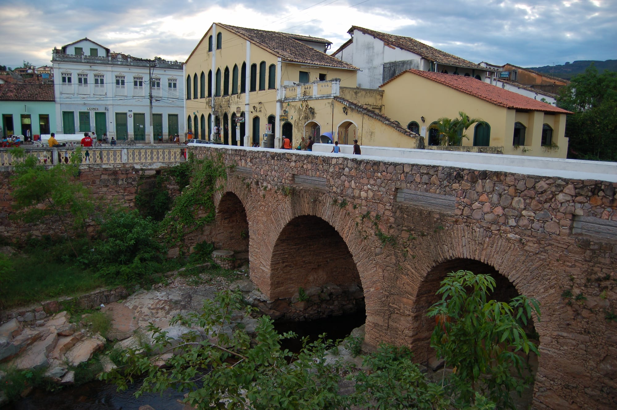
An arched stone bridge over a rocky river bed, with colonial houses in yellow and white on the bank behind

Bahia, Brazil

Lençóis

The 19th-century stone bridge over the river in the historic centre of Lençóis. (Patricia Silva from Santiago, Chile / Wikimedia Commons · CC BY 2.0)

A small town of cobbled lanes and 19th-century houses on the Lençóis river in the Chapada Diamantina of inland Bahia. Founded in the 1840s diamond rush and for a time one of the most important towns in the state, it declined when the stones ran out and has since become the main base for treks into the Chapada Diamantina National Park.

Neighbourhoods

  • Historic centre
    • First-time visitors
    • Historic district
    • Best for food

    The listed core of about 570 houses and two-storey sobrados from the second half of the 19th century, on an irregular web of steep cobbled lanes and small squares on both banks of the river, joined by a stone bridge. Most pousadas, restaurants, guiding agencies and the two banks are here, and everything is within a few minutes' walk.

    Open in Maps
  • Vale do Capão
    • Hikers
    • Quiet and residential

    A valley village in the neighbouring municipality of Palmeiras, used by many travellers as a second base. It is cooler than Lençóis in the hot months, has its own hostels, and the walk to the top of the Fumaça falls starts there.

    Open in Maps

Things to do

Walks from the town

  • Ribeirão do Meiopark

    A stream about 3 km from town, reached on a signposted trail, one of the swimming spots within walking distance of Lençóis.

    Open in Maps
  • Serrano natural poolspark

    Natural pools in the riverbed about a kilometre from the town, reached on foot.

    Open in Maps
  • Cachoeira do Sossegotrail

    A waterfall and pool reached by a longer walk up a boulder-strewn riverbed beyond the Ribeirão do Meio, about two and a half hours each way.

    Open in Maps
  • Gruta do Lapãoattraction

    A cave about 4 km from town.

    Open in Maps

Short trips into the Chapada

  • Chapada Diamantina National Parkpark

    The national park created in 1985 across about 152,000 hectares of the Sincorá range, with caatinga scrub, Atlantic Forest along the rivers, cave systems and the highest point in Bahia.

    Open in Maps
  • Morro do Pai Inácioviewpoint

    A flat-topped hill of 1,120 metres in the park, climbed on a path of about 2.5 km uphill from the highway.

    Open in Maps
  • Cachoeira da Fumaçatrail

    A waterfall of about 340 metres whose thin stream is blown into spray before it reaches the ground, reached by a 6-kilometre walk from the Vale do Capão or a three-day trek from Lençóis; it can run dry in some seasons.

    Open in Maps
  • Poço Encantadoattraction

    A cave near Itaetê with an underground lake of clear water, best known for the beam of sunlight that falls into it from April to September.

    Open in Maps
  • Gruta da Torrinhaattraction

    A cave near Iraquara, north of the park, known for its mineral formations, including one of the largest aragonite flowers in the world.

    Open in Maps

Eat and drink

Long-standing places and food districts in Lençóis. Hours, ratings and directions come from your maps app, always current.

Lençóis classics

  • Lampião Culinária Nordestinarestaurant

    A restaurant on Rua Miguel Calmon serving north-eastern regional cooking.

    Open in Maps

Food streets

  • Rua das Pedrasneighborhood

    A lane in the centre with restaurants, among them Bodega.

    Open in Maps

Experience Lençóis

History

Lençóis grew out of a diamond rush. Stones were found in the riverbeds of the Chapada Diamantina in the mid-1840s, and prospectors, the garimpeiros, poured in to work the gravel with pans and sluices. The settlement was separated from Santa Isabel do Paraguaçu, now Mucugê, as the Vila de Lençóis in 1856 and became a town in 1864. In the second half of the 19th century it was among the world's leading sources of diamonds and the third most important town in Bahia, rich enough to import luxuries and to host a French vice-consulate. The stone bridge across the river was built around 1860, using labour left idle by the great drought of 1859–1862, and the most elaborate buildings, such as the chapel of Nosso Senhor dos Passos, date from these years.

The discovery of diamonds in South Africa in the 1860s and the exhaustion of the local deposits brought a crisis from the 1870s. Many miners left; others turned to cutting stones, and coffee and later carbonado, a dark form of diamond, revived the economy for a time. In the early 20th century the Lavras Diamantinas were dominated by rural bosses, the coronéis, and their armed men; the most powerful, Horácio de Matos, controlled the region in the 1920s and fought the Prestes Column, and the town's airport now bears his name.

By the mid-20th century the diamonds were largely gone. A community movement won national heritage listing for the town's architecture and landscape from IPHAN in 1973, and the creation of the Chapada Diamantina National Park in 1985 set Lençóis on its course as a centre for walking tourism.

Culture & Customs

The town's identity is still bound up with the garimpo, the small-scale diamond digging that built it. The heritage-listed centre is made of adobe and stone houses that follow the uneven ground, some streets paved with the bare bedrock, with the churches of Nossa Senhora da Conceição and Nosso Senhor dos Passos as its landmarks. Stories of fortunes made and lost and of the coronéis of the 1920s are part of local memory, and the writer Afrânio Peixoto was born here.

Tourism has given the town a cosmopolitan air. From the 1980s to the mid-1990s visitors were mostly young backpackers; today travellers from around the world fill its narrow streets, and agencies, independent guides and climbers share the squares with long-time residents. Agencies in town also arrange rock climbing with guides and equipment.

Life is otherwise that of a small inland Bahian town, Catholic in its calendar and unhurried in pace, with a strong sense of being the gateway to the Chapada.

Daily Life

About 11,000 people live in the municipality, according to the 2024 IBGE estimate, spread over about 1,280 square kilometres. Around 120,000 tourists a year visit, staying on average about eight days, and tourism is the main source of work: pousadas, restaurants, agencies, guiding, transport and craft shops. The town has the best tourist infrastructure in the Chapada, including its airport.

The rhythm of the day follows the visitors. Tour vehicles and groups of walkers leave in the early morning, the streets are quiet in the heat of the day, and the squares fill again at dusk as people come back from the trails to eat outside.

Seasonality is a constant concern. The busy months are the July holidays and the summer holidays around New Year and Carnival, while weekdays out of season are quiet. Heavy rain in the wet season can make the rivers dangerous, and the park that draws the visitors is a protected area administered by the federal Chico Mendes Institute.

Food

Inland Bahia eats differently from the coast. Where Salvador cooks with dendê palm oil and coconut milk, the cooking of the north-eastern interior includes carne de sol, sun-cured beef. These dishes appear on the menus of regional restaurants in town alongside Bahian classics such as moqueca, the fish stew made with coconut milk and dendê.

Because of the many foreign visitors, the choice is wider than in most towns of its size: the restaurants around the main square and in the lanes nearby include Italian kitchens making their own pasta and bread, Arabic food and simple places for a cheap meal. Lampião, on Rua Miguel Calmon, serves north-eastern regional cooking, Bodega is on Rua das Pedras, and handmade lasagne and pizzas in many flavours appear on Italian menus.

Agencies running multi-day treks arrange the food along with transport and guides. The caipirinha, made with cachaça, lime and sugar, is the usual drink at the end of a day on the trails.

Planning tools

Budget

Lençóis is inexpensive by Brazilian standards: simple pousadas, hostels and campsites are plentiful, and meals in town cost little. The main expense is guided trips into the park, whether a day tour by car to the caves and viewpoints or a multi-day trek with food and camping arranged. Prices rise in the July holidays and around Carnival and New Year.

Daily Budget Midrange
USD 70–150 (pousada room, restaurant dinners, a guided day tour or trek)
Daily Budget Shoestring
USD 30–50 (hostel dorm or campsite, set lunches, walks to the river pools without a guide)

The river pools near town can be reached on foot without a guide; longer treks in the park are best arranged with a registered local guide.

Best Time to Visit

The drier months from about April to October are the usual trekking season, when trails and river crossings are safer, though the waterfalls carry less water. From about November to March is the rainy season, when the falls are fuller but heavy rain can make rivers rise quickly. The July school holidays bring the most Brazilian visitors.

Suggested Number of Days

Three or four days covers the town, the walks near it and a couple of guided trips by car into the park. Visitors stay about eight days on average, and a week or more allows a multi-day trek; the season and the need for a guide on longer routes change the number.

First Visit
3–4 days
With Surroundings
6–8 days

Transportation

The park's sights are spread out, and most visitors join tours from the agencies in town, which include transport and a guide, or hire a car. Lençóis lies about 12 km off the BR-242 highway between Salvador and Brasília.

Expect a bumpy ride on the roads around the park and avoid driving them at night.

Airport & Station Connections

Horácio de Mattos Airport serves Lençóis and the national park, with flights from Salvador. Most visitors arrive by bus from Salvador, a journey of about six hours, with extra services in the high season; there are also connections from Brasília via Seabra.

Walkability

The town is small and everything in it is within walking distance, though the cobbled lanes are steep and uneven and need sturdy shoes. Several river pools and waterfalls are reached on foot from the edge of town; the main sights of the park need transport.

Safety

Brazil has high rates of crime, including violent crime, and it is the main practical concern for visitors — though very unevenly distributed. Lençóis itself is a small, quiet tourist town. The bigger risks are in the landscape: flash floods in river canyons after rain, steep and slippery trails, and long days in the sun.

Trek with a registered local guide on longer routes, stay out of narrow canyons when rain threatens upstream, and carry water and sun protection. Check current official travel advice before travelling.

Climate

A tropical climate, moderated by the town's altitude of about 400 metres, with a wet season and a drier season. Seasons are southern-hemisphere — summer is December to February.

Summer
hot and rainy, with heavy downpours that can raise the rivers fast; the record high of 39.8°C was reached in December 2019 and again in October 2023
Winter
warm and drier by day, with cooler nights; the record low is 6.8°C

Local Customs

Lençóis has long been used to backpackers and climbers from around the world, and the atmosphere is relaxed. A service charge is usually added to restaurant bills. Greetings are warm, often with a handshake or a kiss on the cheek.

Dress modestly when entering the churches, carry out all rubbish from the trails, and ask before photographing residents.

Common Payment Methods

The currency is the Brazilian real (R$). Cards and Pix are widely accepted in town, but cash is useful for guides, small shops and stalls on the trails. There is a Banco do Brasil and a Bradesco bank in town.