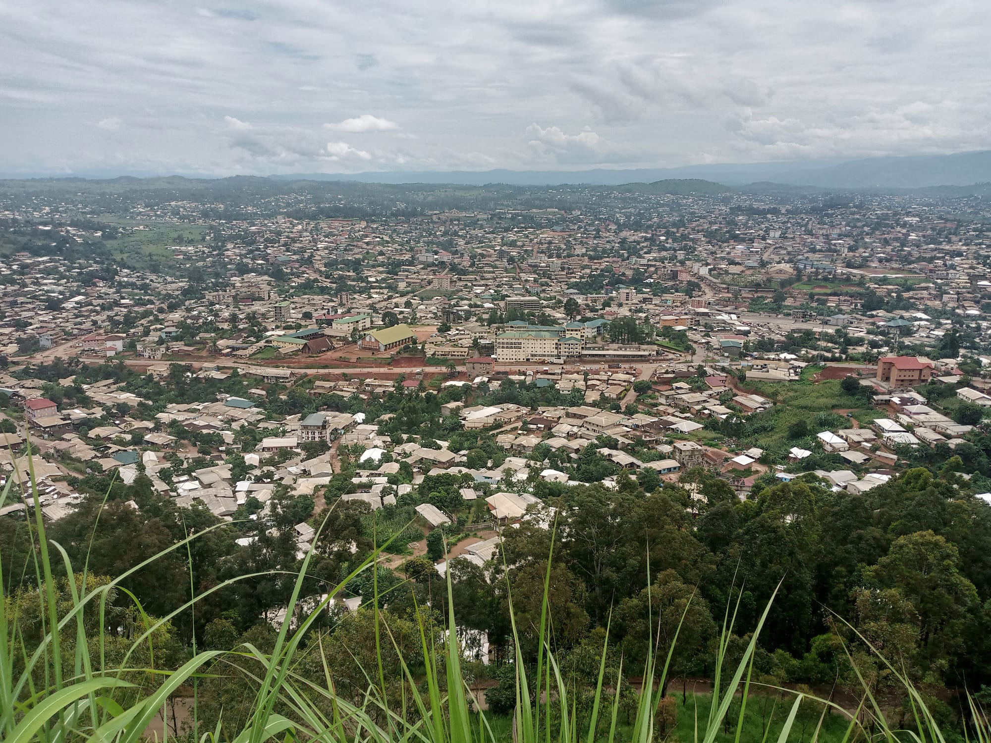
A wide city of low tin-roofed houses filling a green valley, seen from a grassy hilltop with wooded slopes below

Bamenda, Bafoussam & the Western Highlands, Cameroon

Bamenda

Bamenda spread across its valley, seen from the escarpment above the city. (Nikimustakid / Wikimedia Commons · CC BY-SA 4.0)

The capital of Cameroon's Northwest Region and the largest city of the English-speaking grassfields, set where a high escarpment drops to a broad valley about 370 kilometres from Yaoundé. Cool and hilly, it grew as a colonial station among old fondoms such as Mankon, and it has been a centre of the separatist conflict fought since 2017. This page is written to explain the city, not to encourage travel.

Neighbourhoods

  • Commercial Avenue and the town centre
    • First-time visitors
    • Markets
    • Close to public transport

    The main street of the lower town, lined with banks, shops, offices and transport agencies, running beside the city's main market. It is the busiest part of Bamenda and the point from which most people orient themselves.

    Open in Maps
  • Up Station
    • Viewpoints
    • Historic district

    The upper town on the shelf of the escarpment, where the colonial administration built its offices and residences for the cooler air. Government buildings and the governor's residence are here, and the road up gives the long view over the valley.

    Open in Maps
  • Mankon
    • Historic district
    • Local life

    A fondom whose lands form a large part of western Bamenda, with its own palace, council and calendar of ceremonies. Residential quarters, schools and a market surround the royal compound, and the fon remains a figure of authority alongside the city council.

    Open in Maps
  • Nkwen and the eastern quarters
    • Quiet and residential
    • Local life

    Another old fondom absorbed into the city, spreading east towards the Ndop road, with markets, churches and a mixture of family compounds and newer concrete houses on the valley floor.

    Open in Maps
  • Bambili and the university road
    • Students
    • Quiet and residential

    North-east of the centre, on the road climbing towards Ndop, are the campuses and hostels associated with the University of Bamenda, in a string of highland villages cooler and greener than the city below.

    Open in Maps

Things to do

Viewpoints and walks

  • The escarpment road and Up Stationviewpoint

    The hairpin road climbing the cliff north of the centre reaches a shelf where the whole city and its valley are laid out below, the classic view of Bamenda.

    Open in Maps

Palaces and institutions

  • Mankon fondom and palacelandmark

    The compound of one of the grassfields fondoms, whose fon still presides over a court of notables, with a museum at the palace holding art and craft of past centuries; the fondom forms much of western Bamenda.

    Open in Maps
  • University of Bamendalandmark

    The region's English-language public university, whose main campus is at Bambili, north-east of the city among the highland villages.

    Open in Maps

Markets

  • Bamenda main marketmarket

    The city's central market beside Commercial Avenue, selling highland produce, cloth, hardware and household goods, and the hub of trade for the surrounding grassfields.

    Open in Maps

Short trips from the city

  • Bafutattraction

    A fondom about 20 kilometres north-west whose palace compound, with a thatched shrine house among colonial-era buildings, is one of the best known of the grassfields royal courts and houses a museum.

    Open in Maps
  • Kumboattraction

    The capital of the Nso fondom on the Ring Road east of Bamenda, a highland town with a large palace and a market that serves the eastern grassfields.

    Open in Maps
  • Lake Nyosattraction

    A crater lake north of the city that released a cloud of carbon dioxide in 1986, suffocating more than 1,700 people in the valleys below; degassing pipes have since been installed.

    Open in Maps

Seasonal events

  • Grassfields dry-season festivalsDecember to February

    The fondoms of the Bamenda highlands hold annual dances and commemorations in the dry months — Mankon's falls around December and the New Year — when masked societies appear at the palaces and families return home for ceremonies.

  • Cameroon's Youth DayFebruary

    A national holiday marked with parades by schools and associations, historically one of the largest public gatherings in the city.

Eat and drink

Long-standing places and food districts in Bamenda. Hours, ratings and directions come from your maps app, always current.

Grassfields classics

  • Achu and yellow souprestaurant

    The dish of the Northwest — pounded cocoyam shaped into a smooth mound with a well of spicy palm-oil sauce in the middle, eaten by hand and sold in small eating houses across the city.

    Open in Maps
  • Corn fufu and njama njamarestaurant

    Maize fufu with stewed huckleberry greens, the everyday meal of the grassfields, usually served with beef or dried fish.

    Open in Maps

Markets and street food

  • Bamenda main marketmarket

    Highland vegetables, beans, potatoes, spices, palm oil and smoked fish, with cooked-food stalls selling beans and plantain around the edges.

    Open in Maps
  • Evening grills on Commercial Avenueneighborhood

    Soya beef skewers, roast fish, roast plantain and maize are grilled on charcoal along the main streets after dark, with palm wine and bottled beer in the bars behind.

    Open in Maps

Experience Bamenda

History

The Bamenda highlands were settled by grassfields peoples who organised themselves into fondoms — kingdoms ruled by a fon with sacred authority, regulatory societies and titled notables. Mankon, Nkwen, Bafut and their neighbours were established well before the colonial period, trading, raiding and intermarrying across the valley, and the city that exists today was built on their lands.

German forces reached the highlands at the end of the 19th century, fighting a series of campaigns against Bafut and Mankon, and established a station on the escarpment above the valley in the early 20th century because the higher ground was cooler and healthier. After the First World War the territory passed to Britain, which administered the Southern Cameroons as part of Nigeria and made Bamenda a provincial headquarters; English schooling, common law and the Baptist and Presbyterian missions took root, and the settlement spread down the cliff onto the valley floor.

When Southern Cameroons voted in 1961 to join newly independent Cameroon, Bamenda became the main city of the English-speaking north-west. It was a centre of opposition politics from 1990, when the Social Democratic Front was launched here at a rally after which six people were killed by security forces. Grievances over the marginalisation of English-language law and education brought lawyers' and teachers' strikes in 2016, followed by protests and a crackdown; from 2017 an armed separatist conflict has been fought across the Northwest and Southwest regions, with Bamenda at its centre.

Culture & Customs

Bamenda is the main city of the grassfields. The fondoms that make up the city — Mankon, Nkwen, Nsongwa and others — keep palaces, councils of notables and masked regulatory societies whose appearances at funerals, enthronements and annual dances are the high points of the year. Carved stools and doorposts, beaded thrones and masks, indigo ndop cloth and elephant masquerade costumes belong to a court art shared across the highlands.

Language marks the city out. Cameroonian Pidgin English is the everyday speech of markets, taxis and bars; English is used in school, church and court; and grassfields languages such as Mankon and Nkwen are spoken at home. Presbyterian, Baptist and Catholic churches, all rooted in 19th- and 20th-century missions, anchor social life, and choirs and church associations are important networks.

Funerals — usually celebrations of a long life, with all-night wakes, dancing and the return of family members from the coast and abroad — are the city's biggest social events. Football, music and comedy in Pidgin thrive among a young population, and Bamenda has a long reputation for political outspokenness. Since 2017 much of this public life has been curtailed by lockdowns, curfews and displacement, and many ceremonies now happen in smaller and quieter form.

Daily Life

The city has a population of about 600,000, which makes it one of Cameroon's larger cities, and it has absorbed many people displaced from the surrounding countryside as well as losing others to Douala, Yaoundé and abroad.

The economy rests on trade, farming and public services. The highlands around the city are among the most intensively farmed land in Cameroon, producing maize, beans, potatoes, vegetables and arabica coffee, and Bamenda's traders move that produce to the coastal cities. Commercial Avenue holds the banks, shops and transport agencies; the regional administration, hospitals, schools and the university employ many others; and small workshops, tailoring and motorcycle taxis absorb much of the rest.

Everyday life is shaped by the conflict. Lockdowns called for particular days close shops and empty the streets, curfews shorten the evening, schools have lost years of teaching, and checkpoints slow every journey. Families rely heavily on remittances from relatives abroad. Between these disruptions the ordinary rhythm persists: markets in the morning, taxis grinding up the escarpment, football on open ground in the afternoon and grills lit along the main roads at dusk.

Food

Achu is the dish of the Northwest and of Bamenda in particular: cocoyam pounded until smooth, shaped into a mound with a hollow in the centre and eaten by hand with a yellow soup, a spicy sauce of palm oil emulsified with limestone water and flavoured with bush spices, beef, cow skin and dried fish. It is the food of ceremonies as well as of ordinary days.

The everyday staple is corn fufu with njama njama, stewed huckleberry greens, a combination sold in every eating house. Around it are beans with fried plantain for breakfast, rice with groundnut or tomato sauce, kati kati — chicken grilled over wood and served in palm oil — and pepper soup. The highland farms supply potatoes, carrots, cabbage, beans and avocados, and cattle from the Mbororo herds on the surrounding hills provide beef.

Street food is straightforward: soya skewers dusted with spiced groundnut, roast fish with pepper sauce, roast plantain and maize, puff-puff and groundnuts sold in twists of paper. Palm wine is the traditional drink, brought in from the lower valleys, and locally brewed corn beer appears at ceremonies; arabica coffee grown in the highlands is more often exported than drunk at home.

Planning tools

Budget

Bamenda has always been an inexpensive city — cheap highland food, simple hotels and shared transport. The conflict has changed the arithmetic more than prices have: hotels and restaurants have closed, movement is unpredictable, and a private vehicle with a driver is usually the only practical way to travel.

Daily Budget Midrange
USD 70–140 (mid-range hotel, restaurant meals, a hired car with driver)
Daily Budget Shoestring
USD 25–50 (basic hotel, local food, shared taxis and motorcycle taxis)

Carry cash in Central African CFA francs; banks and cash machines exist on Commercial Avenue but service is interrupted during lockdowns.

Best Time to Visit

The dry season from about November to February is the brightest and easiest time in the highlands, and the season of palace ceremonies and funerals. From about June to September the rains are heavy, roads on the Ring Road turn to mud, and cloud sits over the escarpment for days.

Suggested Number of Days

The city itself is quickly seen — a market, a viewpoint and a palace. The time goes on the grassfields around it, whose fondoms, lakes and highland roads take several days. Road conditions and security restrictions affect the number far more than distance does.

First Visit
1–2 days
With Surroundings
3–5 days

Transportation

Shared yellow taxis run along the main roads and motorcycle taxis, known as okada, cover everything else; minibuses and coaches leave the motor parks for Bafoussam, Douala and Yaoundé, and for the Ring Road towns. Roads in the Northwest Region are subject to checkpoints, curfews and separatist-imposed lockdowns, and journeys are cancelled at short notice.

Travel by day and with established coach companies, and expect frequent police and gendarmerie checkpoints on every road.

Airport & Station Connections

Bamenda is about 370 kilometres from Yaoundé by road, and most people arrive by coach from Bafoussam, roughly two to three hours away, or directly from Douala or Yaoundé in most of a day. Bamenda Airport, in the Bafut subdivision outside the city, carried flights to Douala and Yaoundé from 2017 until all operations were suspended in 2020, so air travel is not a practical option.

Walkability

The lower town around Commercial Avenue and the market is flat and walkable, and the grid of streets there is easy to follow. Everything else involves the escarpment: Up Station is a long, steep climb above the centre, and the outer quarters spread several kilometres along the valley, so most residents use shared taxis or motorcycle taxis.

Safety

Bamenda is the capital of the Northwest Region and has been a centre of the armed conflict between separatist groups and Cameroonian security forces since 2017. Kidnappings, attacks on checkpoints, curfews and separatist-imposed lockdowns that empty the streets have affected the city repeatedly, schools and businesses have closed for long periods, and there is a heavy military presence. Petty crime adds to the risk in crowded areas.

Most governments advise against all travel to the Far North and to the Northwest and Southwest regions. That includes Bamenda and the Ring Road. Avoid gatherings and do not photograph soldiers, police, checkpoints or government buildings. Check current official travel advice before travelling.

Climate

Bamenda sits high in the grassfields and is known for a cool, misty climate unlike the lowlands. Mornings are often foggy on the escarpment, the rainy season is long and heavy, and nights are chilly enough for a jacket throughout the year.

Summer
the heart of the rains, cloudy and wet, with daytime temperatures usually around 20–26°C
Winter
the dry season from about November to February, sunny with Harmattan dust, around 24–29°C by day and cold at night

Local Customs

This is an English-speaking city where Cameroonian Pidgin English is the street language and the fondoms still matter: fons, notables and traditional councils are respected, and a visit to a palace is arranged through an intermediary rather than turning up. Funerals and commemorations are major social occasions, and churches are full on Sundays. Dress is modest and neat.

Greet people before asking anything, ask permission before taking photographs, and never photograph soldiers, police, checkpoints or damaged buildings.

Common Payment Methods

The currency is the Central African CFA franc, written FCFA and pegged to the euro. Cash is used for almost everything; mobile money is widely used by residents. Bank branches and cash machines are concentrated on Commercial Avenue, and their availability varies with conditions in the city.