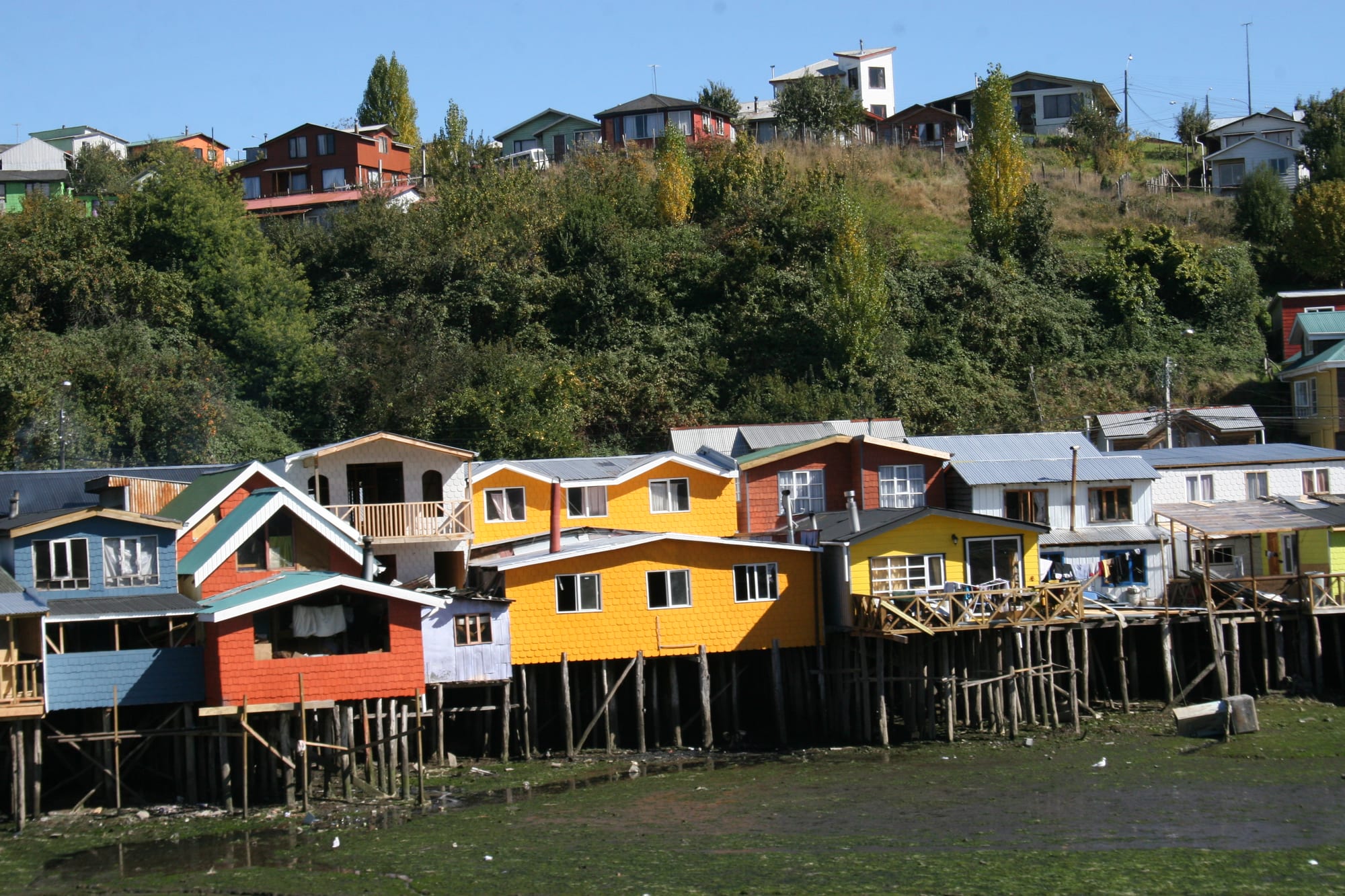
A row of brightly painted wooden houses raised on stilts above a muddy shore at low tide, with a wooded hill behind

The Lake District & Araucanía, Chile

Castro

Palafitos, the traditional stilt houses of Chiloé, on the waterfront at Castro. (Cplandco / Wikimedia Commons · CC BY-SA 4.0)

The capital of Chiloé Province, on a sheltered inlet on the eastern coast of Chiloé Island in southern Chile. Founded by the Spanish in the 16th century and one of the country's oldest cities, it is known for its palafitos, wooden houses on stilts over the water, and for the shingled Church of San Francisco on its main square, part of a UNESCO World Heritage Site.

Neighbourhoods

  • Centre and Plaza de Armas
    • First-time visitors
    • Best for food
    • Close to public transport

    The town has always revolved around its main square, with a fountain topped by a statue of the Pincoya, the town hall and the Church of San Francisco, ringed by shops, banks, bars and restaurants. The bus terminals are a block or two away, and Calle Blanco runs down to the waterfront.

    Open in Maps
  • Gamboa
    • Palafitos
    • Photography
    • Quiet and residential

    The district on the west side of town, by the bay known as the Fiordo de Castro, where a row of preserved palafitos stands over the water. It also has a wooden chapel, and boats are still built in the traditional way at a wharf between here and the centre.

    Open in Maps
  • Pedro Montt waterfront
    • Palafitos
    • Walks

    The shore north of the old railway yard, lined with the long row of stilt houses known as the Palafitos Montt, best seen from the water or from a viewpoint at the northern end. The port and craft market are just to the south.

    Open in Maps
  • Nercón
    • Historic church
    • Quiet and residential

    A village about 5 km south of the centre that was incorporated into Castro in 2007, home to one of the UNESCO-listed wooden churches and a small boatbuilding wharf by the bridge over the Nercón river.

    Open in Maps

Things to do

Churches and landmarks

  • Church of San Franciscolandmark

    The main church of Chiloé's capital, a large wooden building of 1912 on the Plaza de Armas with towers 42 metres high, declared a national monument in 1979 and part of the UNESCO-listed Churches of Chiloé since 2000.

    Open in Maps
  • Church of Nercónlandmark

    Nuestra Señora de Gracia, built in 1886–90 of native coigüe wood, with a well-kept garden in front; one of the sixteen churches of the Chiloé World Heritage Site.

    Open in Maps
  • Plaza de Armaslandmark

    The central square and its park, with the Pincoya fountain at the centre — the heart of Castro since its founding.

    Open in Maps
  • Palafitosneighborhood

    The town's traditional wooden houses on stilts, once common across Chiloé; many were destroyed by the 1960 earthquake and tsunami, and the surviving rows stand in the Gamboa and Pedro Montt districts.

    Open in Maps
  • Plazuela del Trenattraction

    A small park on the old railway yard by the harbour, displaying a locomotive and other relics of the Castro–Ancud line that ran from 1912 until the 1960 earthquake.

    Open in Maps
  • Parish cemeteryattraction

    A cemetery with grand, ornately decorated tombs, a quiet place for a walk.

    Open in Maps

Museums

  • Regional Museum of Castromuseum

    A museum of objects made in Chiloé, with ethnographic and archaeological collections.

    Open in Maps
  • Museum of Modern Art of Chiloémuseum

    A contemporary art museum founded in 1988 in the Municipal Park on the upper side of town, open during exhibitions.

    Open in Maps

Markets

  • Feria Artesanal Lillomarket

    The craft market on the waterfront by the port, selling hand-knitted woollens, woodwork and basketry.

    Open in Maps
  • Feria Campesina Yumbelmarket

    A busy farmers' market of fruit and vegetables, with fish stalls and household goods, north-west of the hospital.

    Open in Maps

Short trips from the town

  • Dalcahue churchlandmark

    The late 19th-century wooden church on the main square of the port town of Dalcahue, built on the site of a Jesuit mission chapel and one of the UNESCO-listed churches.

    Open in Maps
  • Church of Chonchilandmark

    The wooden church of the town of Chonchi, south of Castro, another of the Churches of Chiloé World Heritage Site.

    Open in Maps
  • Achao churchlandmark

    Built around 1740 on Quinchao Island, one of the oldest of the Chiloé churches, surviving almost intact from the Jesuit mission era.

    Open in Maps
  • Chiloé National Parkpark

    A park on the island's Pacific coast of dunes, Valdivian temperate rainforest, swamps and peat bogs in the foothills of the coastal range.

    Open in Maps

Seasonal events

  • Festival Costumbrista ChiloteFebruary

    Held each summer in the Municipal Park, the largest festival of its kind in southern Chile, showing Chilote food, crafts, folk music and customs.

Eat and drink

Long-standing places and food districts in Castro. Hours, ratings and directions come from your maps app, always current.

Food districts and markets

  • Calle Blanconeighborhood

    Most of the town's restaurants and cafés are along this street, which runs from the southern side of the main square down to the waterfront.

    Open in Maps
  • Feria Campesina Yumbelmarket

    The farmers' market where fruit, vegetables and fish are sold.

    Open in Maps
  • Cafés for oncecafe

    Cafés around the main square fill in the late afternoon, when residents stop for once, the Chilean evening tea of cakes and sandwiches.

    Open in Maps

Experience Castro

History

Castro is Chile's third-oldest city in continuous existence. Captain Martín Ruiz de Gamboa founded it during the campaign launched in 1567 to conquer Chiloé and subdue its inhabitants, the Cuncos, naming it Santiago de Castro after the apostle James and the acting Viceroy of Peru, Lope García de Castro. It was the administrative centre of the island until 1767, and in 1594 had some 8,000 inhabitants, most of them farmers. Dutch raiders looted the town several times up to the mid-17th century, and in colonial times it was the site of a small fort system.

In 1767, when Chiloé was placed directly under the Viceroyalty of Peru, the capital moved to Ancud for easier communication with Lima, and it stayed there after Chiloé joined the Chilean republic. An earthquake destroyed Castro in 1837, and by 1907 only 1,243 people lived there. The railway to Ancud, opened in 1912, revived the town, and the Church of San Francisco was built the same year.

The earthquake and tsunami of 1960 destroyed or damaged many buildings, including the railway station, the town hall and many of the palafitos, and the railway was never rebuilt. Castro regained its role as capital of the archipelago only in 1982. In 2000 its church became part of the UNESCO World Heritage Site of the Churches of Chiloé, in 2007 the village of Nercón was incorporated into the city, and on 10 December 2021 a fire destroyed several structures and forced residents to evacuate.

Culture & Customs

Castro's culture is the culture of Chiloé, an island world apart from mainland Chile. Its wooden churches, built in native timber and covered in shingles, are the best-known expression of it: they fuse the traditions of the Spanish Jesuit missions with the building skills of the local people, and sixteen of them across the archipelago, including San Francisco in Castro and the church at Nercón, form a UNESCO World Heritage Site. Wood shapes the town in other ways too — the shingled houses, the palafitos over the water, and the boats still built by hand at wharves near the centre and at Nercón.

Island mythology is part of local identity. The Pincoya, the sea spirit of island legend, stands at the centre of the fountain in the main square. Crafts are another: the market on Calle Lillo sells hand-knitted woollens, woodwork and basketry.

The great event of the year is the Festival Costumbrista Chilote, held every summer in the Municipal Park and described as the largest of its kind in southern Chile, with island food, crafts, folk music and customs. The same park hosts a biodiversity fair showing the many potato varieties grown in the archipelago. In sport, Castro has a strong basketball tradition: Deportes Castro won the national league in 2012, and several local football clubs play in the town association.

Daily Life

The city had about 33,000 inhabitants at the 2017 census, and the wider commune about 43,800, making Castro the main town of Chiloé and the service centre for the whole archipelago. As provincial capital it has the government offices, the hospital, banks and shops, and people from the smaller towns and islands come here for business and services.

The economy combines public administration, commerce and tourism with the activities of the surrounding island: farming, fishing and salmon farming, with some 1,400 salmon farms spread among the islands. Visitors come for the churches and palafitos, and some of the stilt houses in Gamboa now hold guesthouses, alongside those still lived in as homes.

The town is built on hills above its inlet, and daily life runs between the square, the waterfront, the markets and the two bus terminals, from which buses run to almost every village on the island. Rain is a constant companion, especially in winter. Access to the mainland is by ferry across the Chacao Channel; the bridge under construction across it is planned to open in 2028 and is expected to change the island's links with the rest of Chile.

Food

Chiloé's cooking is among the most distinctive in Chile. Its signature is curanto, in which shellfish, meat, sausage and potato dumplings are cooked over hot stones in a pit, covered with nalca leaves; milcao, a kind of potato pancake, is cooked with it. The island grows hundreds of native potato varieties, which are shown each year at a biodiversity fair in Castro's Municipal Park.

Seafood is everywhere. The farmers' market on Yumbel street sells fruit and vegetables alongside fish, and the waters around Chiloé produce shellfish and farmed salmon. Restaurants and cafés are concentrated along Calle Blanco, which runs from the main square to the waterfront, and the Festival Costumbrista in summer is the chance to taste island dishes prepared in the traditional way.

Castro's cafés are busiest in the late afternoon, when residents stop for once, the Chilean evening tea of bread, cakes and sandwiches. Chicha de manzana, apple cider, is the old drink of the southern countryside.

Planning tools

Budget

Castro and the Chiloé villages are good value compared with the lake resorts, and there is a wide choice of guesthouses and small hotels. The ferry across the Chacao Channel adds to the cost of bringing a car, but a car is the most convenient way to explore the island; rural buses are cheap.

Daily Budget Midrange
USD 90–180 (small hotel or palafito guesthouse, restaurant dinners, a boat trip, a hire car)
Daily Budget Shoestring
USD 35–60 (hostel or guesthouse, market and set-menu meals, local buses)

Carry cash for rural Chiloé, and allow extra time for the Chacao ferry queue in summer.

Best Time to Visit

December to March is the warmest and driest time, with February the driest month and the time of the Festival Costumbrista. Rain falls through the year, heaviest in winter, and July is the wettest month. The churches and palafitos can be seen in any season.

Suggested Number of Days

Two or three days suit the town itself. Four to six give time for the other churches, the eastern islands and the Pacific coast, which are reached by bus, car or ferry. Rain and ferry timings can slow island travel, so extra time is useful.

First Visit
2–3 days
With Surroundings
4–6 days

Transportation

Castro is the hub of the island: nearly every village is reached on a good paved road, and local buses to Dalcahue, Achao, Chonchi and the national park leave from the municipal terminal a few blocks from the square. Tour boats leave from near the port to view the palafitos from the water. A hire car is the most flexible way to see the island.

Long-distance buses and local buses use different terminals, both close to the main square.

Airport & Station Connections

Mocopulli Airport, about 19 km from the centre in the neighbouring commune of Dalcahue, has domestic flights linking the island with the rest of Chile. Most visitors come by road: buses from Puerto Montt take a few hours, crossing the Chacao Channel by ferry, and overnight buses from Santiago take about 16 hours. A bridge over the channel is planned to open in the second half of 2028. In summer a ferry runs to Chaitén on the mainland, and from Quellón in the south of the island ferries sail to Chaitén and Puerto Chacabuco.

Walkability

The town is small and easily covered on foot, though it climbs steeply from the waterfront. The tourist office on the square has maps with a walking route. The main square, the craft market, the train park and the Pedro Montt palafitos are a short walk apart; Gamboa and Nercón are further, and the Municipal Park is on the upper side of town.

Safety

Chile is one of the safer countries in South America, but petty and opportunistic crime has risen, especially in Santiago and Valparaíso — pickpocketing, bag-snatching, phone theft, and distraction scams in tourist areas, markets, and on transport. Castro is a quiet town. The greater risks are natural: the 1960 earthquake and tsunami destroyed or damaged many buildings, including many of the palafitos, and in December 2021 a fire destroyed several buildings and forced residents to evacuate.

Learn the tsunami evacuation routes near the shore, take care on wet wooden walkways and steep streets, and dress for rain and wind. Check current official travel advice before travelling.

Climate

A cool climate on the border between Mediterranean and oceanic, with about 1,830 mm of rain a year. Summers are mild and comparatively dry; winters are cool and very wet, with July the wettest month. Wind and cloud are common all year.

Summer
December–February is mild, with daily mean temperatures of about 16°C in January and February
Winter
June–August is cool and wet, with daily mean temperatures of about 7°C in July

Local Customs

Chiloé has its own identity, shaped by Jesuit and Franciscan missions, a culture of wooden building and boats, and a mythology of beings such as the Pincoya, whose statue stands in the main square. The churches are working parishes. Life is quieter and more rural than in the mainland cities.

Dress modestly and stay quiet in the churches during services, and ask before photographing people at their homes in the palafitos or at market stalls.

Common Payment Methods

The currency is the Chilean peso (CLP). Cards are accepted in most hotels and restaurants in town, and there are banks and ATMs around the main square, though they charge fees and cap withdrawals. Cash is needed in the markets, on rural buses and in the smaller villages.