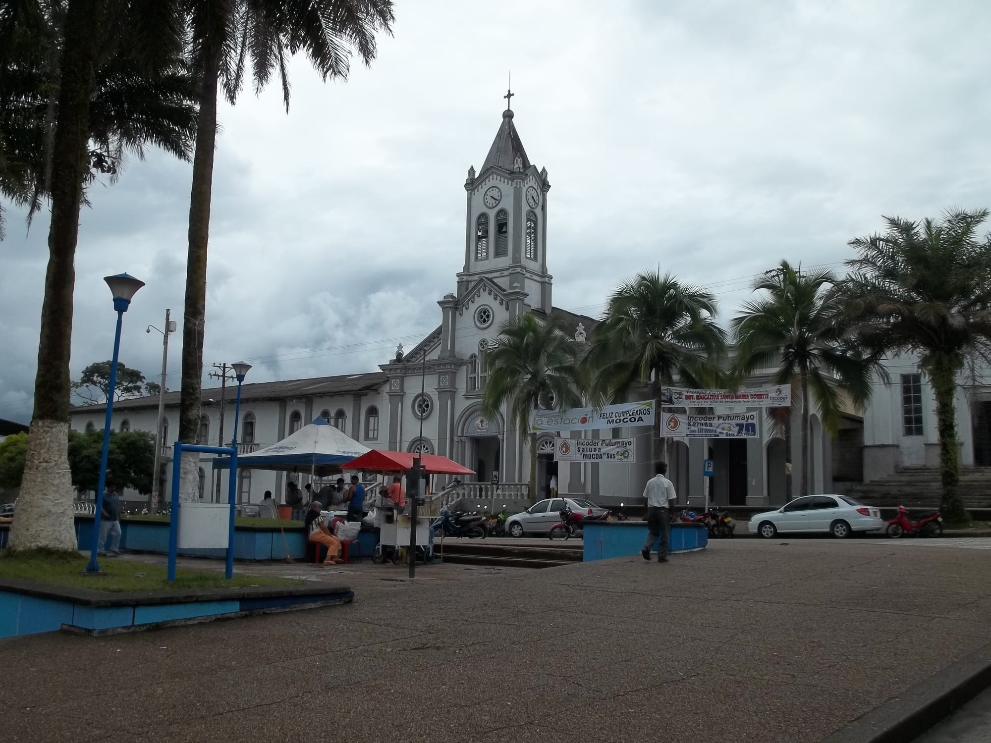
A white church with a clock tower behind a paved square lined with palm trees, food stalls and parked motorbikes

The Amazon & the South, Colombia

Mocoa

The main square of Mocoa, with the church and its clock tower. (Juan Camilo Macias / Wikimedia Commons · CC BY 2.0)

The capital of Putumayo, a small city where the last slopes of the Andes meet the Amazon rainforest in the basin of the Caquetá. Founded by the Spanish in the 16th century, it is the department's trading centre, was devastated by floods and mudflows in 2017, and is a base for rainforest walks to waterfalls such as the Fin del Mundo.

Neighbourhoods

  • The centre and main square
    • First-time visitors
    • Local life
    • Food stalls

    The palm-shaded main square with its white church, a small tourist office, shops and simple restaurants, uphill from the bus station. Street food is sold around the square, and most of the city's errands are done within a few blocks.

    Open in Maps
  • Around the bus terminal
    • Close to buses
    • Budget stays
    • Markets

    The area below the centre where buses arrive from Pitalito, Pasto and Neiva, with many inexpensive hotels and a large market right next to the terminal.

    Open in Maps
  • The road to Villagarzón
    • Nature
    • Hostels
    • Walking

    The road running out of the city towards Villagarzón, where backpacker hostels and riverside lodgings sit close to the trailheads for the Fin del Mundo and Hornoyaco waterfalls, among rainforest on the edge of the foothills.

    Open in Maps

Things to do

Waterfalls and rainforest walks

  • Fin del Mundo waterfalltrail

    The best-known walk near Mocoa, about 6 km from the city off the road to Villagarzón: a trail along the Dantayaco stream, past rock pools and smaller falls, to a main drop of about 70 metres with views over the mountains and parts of the city.

    Open in Maps
  • Ojo de Dios waterfalltrail

    A waterfall close to the Fin del Mundo, reached on less-used trails that should only be walked with a guide.

    Open in Maps
  • Hornoyacotrail

    A quieter waterfall walk about an hour from the road to Villagarzón, 2 km from the city; music, alcohol, food and camping are not allowed.

    Open in Maps

In the city

  • Centro Experimental Amazónicoattraction

    A centre caring for Amazonian wildlife rescued from trafficking, such as jaguars, anacondas, turtles and birds, with exhibitions on Indigenous culture and the history of Putumayo.

    Open in Maps
  • Main squarelandmark

    The palm-lined centre of the city, with its white church and clock tower, food stalls and the daily comings and goings of a departmental capital.

    Open in Maps

Short trips from the city

  • Villagarzónattraction

    The neighbouring town and municipality, about 14 km away, near the airport that serves Mocoa.

    Open in Maps
  • Sibundoyattraction

    A town in the high valley above Mocoa where most people are Kamëntšá or Inga, known for mask carving and for the fallen tree trunks in its park carved with symbols from their mythology.

    Open in Maps

Eat and drink

Long-standing places and food districts in Mocoa. Hours, ratings and directions come from your maps app, always current.

Mocoa classics

  • River fishrestaurant

    Freshwater fish from the rivers of the Amazon basin are the local speciality in the small restaurants around the main square.

    Open in Maps
  • Jungle-fruit juicesrestaurant

    Juices pressed from the fruits of the rainforest are sold at stalls and restaurants across the centre.

    Open in Maps

Food districts and markets

  • Market by the bus terminalmarket

    A large market right next to the bus station, with fruit, vegetables, meat and fish from the farms and rivers around the city.

    Open in Maps
  • Restaurants around the main squareneighborhood

    Numerous small restaurants serve almuerzos, the cheap set lunches, and street food is sold around the square.

    Open in Maps

Experience Mocoa

History

Mocoa was founded by the Spanish in the mid-16th century. Under the name San Miguel de Agreda de Mocoa it suffered frequent attacks, and it was moved to its present site on the Mocoa river, where the Mulato and Sangoyaco rivers join it. For centuries it remained a remote outpost on the edge of the Amazon, linked to the Andes by mountain trails.

Mocoa became a municipality in 1953, as part of Nariño, and was separated from that department in 1957 under the military junta. It grew as the administrative capital of Putumayo and the commercial centre of a department based on farming and cattle. In 2009 a new road corridor from San Francisco to Mocoa was planned to link the Pacific coast with the Amazon; work on a 42 km section with 46 viaducts began in 2012.

In the early hours of 1 April 2017, after an unusually wet March, torrential rain made the Mocoa, Sangoyaco and Mulato rivers overflow, sending flash floods and mudflows through the city. More than 300 people were killed, hundreds were injured, 17 neighbourhoods were affected and the Independencia neighbourhood was entirely destroyed; it was the worst catastrophe in Mocoa's history. President Juan Manuel Santos declared a state of emergency, and thousands of soldiers, police and aid workers joined the rescue.

Culture & Customs

Mocoa sits where the cultures of the Andes and the Amazon meet. Its Kamëntšá name is Shatjok, and the Kamëntšá and Inga peoples of the Sibundoy valley above the city, along with other Indigenous peoples of Putumayo, shape the region's crafts, languages and ceremonies. In Sibundoy, Indigenous residents wear long blue and violet ponchos, carve masks, and have carved the fallen tree trunks of the town park with symbols from their mythology. The Inga descend from a Quechua-speaking settlement founded under the Inca ruler Huayna Cápac, and both their language and Kamëntšá are still widely spoken there alongside Spanish.

Yagé, the plant brew known elsewhere as ayahuasca, is central to the healing traditions of Putumayo. Its use in ceremonies for visitors has become commercialised.

Nature is the city's other identity. The rivers, waterfalls and rainforest around Mocoa draw walkers, and local operators offer adventure activities such as rappelling down the Fin del Mundo waterfall. The Centro Experimental Amazónico cares for wildlife rescued from trafficking and explains Indigenous culture and Putumayo's history.

Daily Life

Mocoa had about 38,500 people at the 2018 census, up from about 27,000 in 2005. The municipality covers about 5,600 square kilometres of mountains, rainforest and flat farming and grazing land in the Caquetá river basin.

As the capital, the city is the economic centre of Putumayo, whose economy rests on agriculture and cattle; government offices, commerce and services provide many of the jobs, and several universities run campuses or distance programmes here. The city lies just off the highway between Pasto and Puerto Asís, and buses and colectivos tie it to the rest of the department.

Life follows the rain. Annual rainfall is very high, most of it falling from April to July, and the mountain roads out of the city are prone to landslides. The 2017 disaster struck hardest at the neighbourhoods built along the riverbanks, and it remains the defining event of recent memory. Days are busy around the bus terminal, the market and the main square, where street food is sold and motorbikes are the usual way around.

Food

Mocoa's table draws on the rivers and the forest. Freshwater fish from the rivers of the Amazon basin are the local speciality, served in the small restaurants around the main square. Almuerzos, the set lunches, are notably cheaper here than in Colombia's larger cities, and street food is sold around the square.

The forest supplies fruit, and juices made from jungle fruits are sold across the city. The large market beside the bus terminal is the place to see the produce of the surrounding farms and rivers — fruit, vegetables, fish and meat.

Out on the waterfall trails, hostels and stalls along the Fin del Mundo walk serve lunches and dinners to walkers, at higher prices than in the city. One hostel, about halfway along the trail, also serves meals to walkers and offers dormitory beds and private rooms. Cold drinks are welcome after the climb, and fresh juices made from the fruits of the forest are sold across the city.

Planning tools

Budget

Mocoa is inexpensive. Set lunches in the city are notably cheaper than in larger Colombian cities, and hotels near the bus station and the square are reasonably priced. Costs rise on the trails: meals at the hostels and stalls along the Fin del Mundo walk cost more, and guides, entry fees and adventure activities such as rappelling are extra.

Daily Budget Midrange
USD 60–120 (private room near the trails, guided walks, sit-down meals, taxis)
Daily Budget Shoestring
USD 25–45 (hostel dorm or simple hotel, set lunches, colectivos, waterfall entry)

Use a guide for the less-visited waterfalls, and agree what is included before setting off.

Best Time to Visit

Mocoa is warm and wet all year, and it rains heavily in every season. Most rain falls from about April to July, when trails are muddiest and streams highest, so the months either side are the more comfortable time for waterfall walks.

Suggested Number of Days

Two or three days are enough for the city and the best-known waterfall walks. Allow four or five to include the surrounding valleys and towns as well. Rain can close trails or delay buses, so a spare day helps.

First Visit
2–3 days
With Surroundings
4–5 days

Transportation

The city is small enough to explore on foot; the centre is uphill from the bus station. Colectivos run every few minutes along the main roads to nearby places, including the road to Villagarzón that passes the waterfall trailheads, and 4x4 colectivos and buses serve the surrounding towns.

For the waterfall walks, wear boots with grip and long clothing, and carry rain gear.

Airport & Station Connections

Mocoa is served by Villa Garzón Airport, also called Cananguchal Airport, near the neighbouring town of Villagarzón; Puerto Asís has a larger airport. Buses come from Pitalito, Neiva and Pasto, and from Ecuador via the San Miguel border crossing. The road up to Pasto, known as the trampolín de la muerte, is steep, narrow and prone to landslides.

Walkability

The compact centre is easy on foot, though the climb from the bus station to the main square is steep. Beyond the centre the roads are busy with motorbikes, and the waterfalls are reached by colectivo followed by muddy forest trails.

Safety

Colombia is far safer for visitors than its reputation, and the main cities and tourist regions are well travelled, but crime requires attention. Rural Putumayo has armed groups — mainly FARC dissident factions and trafficking networks — linked to coca and illegal logging, and remote areas away from the main towns are best avoided. Heavy rain is the other risk: the city and the mountain roads around it are prone to floods and landslides.

Keep to the main towns and known trails, travel by day on the mountain roads, use guides on remote paths, and take anti-malarial and yellow fever advice. Check current official travel advice before travelling.

Climate

Hot, humid and very wet. The mean yearly temperature is about 21°C, with daily minimums of about 16–17°C and maximums of about 28–29°C, and annual rainfall of about 420–460 cm.

Summer
the less rainy months, outside April–July, still bring frequent showers, with maximums around 28–29°C
Winter
April–July brings most of the rain, with torrential downpours, rising rivers and minimums around 16–17°C

Local Customs

Mocoa mixes settlers from the Andes with Indigenous peoples of Putumayo — its Kamëntšá name is Shatjok. Yagé, the plant brew known elsewhere as ayahuasca, is central to the region's healing traditions, though ceremonies for visitors have become commercialised. The 2017 disaster remains painful for many families.

Treat Indigenous ceremonies with respect and approach yagé offers with caution; ask before photographing people, and keep to trail rules at the waterfalls.

Common Payment Methods

The currency is the Colombian peso (COP). Cash is needed for colectivos, set lunches, market stalls, trail entry fees and most hostels. The city has banks and ATMs; withdraw inside a bank by day, and carry enough cash before heading out to the trails or smaller towns.