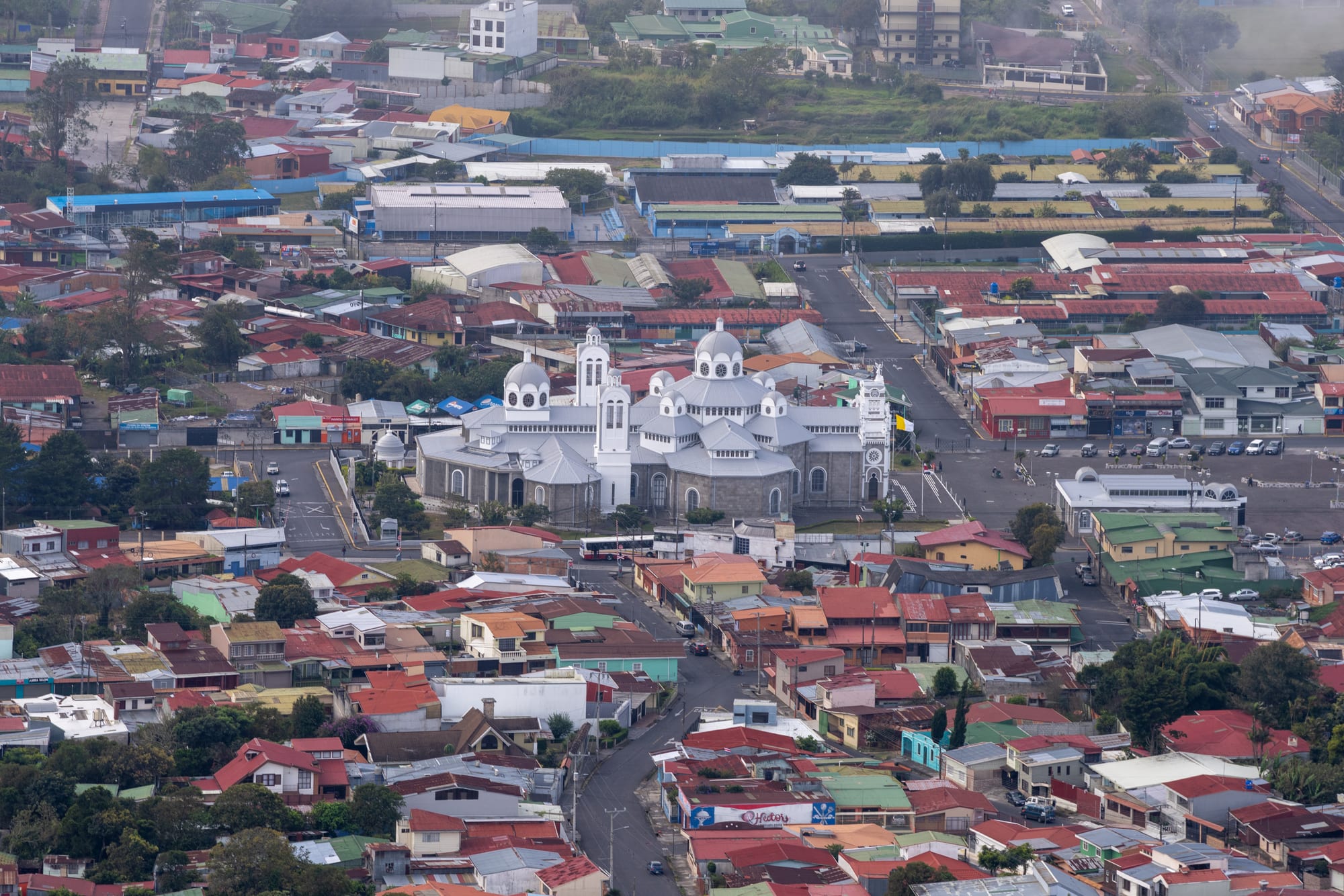
Aerial view of a large grey domed basilica with white towers among the red and green roofs of a city

San José, the Central Valley & Arenal, Costa Rica

Cartago

The Basilica of Our Lady of the Angels and the streets around it in Cartago, seen from the air. (IgnacioAFQ / Wikimedia Commons · Public domain)

Costa Rica's first lasting Spanish town, founded in 1563 at the foot of the Irazú volcano and the capital until 1823. Earthquakes severely damaged the old city, but its basilica of the Virgin of the Angels makes it the country's religious heart. Today it is a provincial capital and commuter city, with the Orosi valley close by.

Neighbourhoods

  • The historic centre
    • First-time visitors
    • Historic district
    • Close to public transport

    The old grid around the Plaza Mayor and the roofless Santiago Apóstol church, with the City Museum two blocks north and the central market nearby. The city government is declaring a hundred blocks here its historic centre.

    Open in Maps
  • Los Ángeles and the basilica
    • Pilgrimage sites
    • Religious heritage

    The eastern side of the centre, about seven blocks from the Plaza Mayor, built around the great domed basilica and its square, where pilgrims gather every August.

    Open in Maps
  • Dulce Nombre
    • Students
    • Quiet and residential

    A district on the edge of the city that holds the campus of the Costa Rica Institute of Technology, one of Central America's leading engineering schools, not far from the basilica.

    Open in Maps
  • The Orosi valley
    • Countryside
    • Colonial churches
    • Quiet stays

    A green valley of coffee and sugar cane south-east of the city, with the colonial church of Orosi, the Ujarrás ruins and Lake Cachí. Guesthouses here make a rural alternative to staying in town.

    Open in Maps

Things to do

Famous landmarks

  • Basilica of Our Lady of the Angelslandmark

    The country's principal church, home of the small dark statue of the Virgin known as La Negrita; the present building, mixing colonial and Byzantine styles, dates from 1939.

    Open in Maps
  • Santiago Apóstol Parish Ruinslandmark

    The stone walls of a Romanesque church begun in 1870 and abandoned after the 1910 earthquake, on a site with churches since 1575, now a garden on the Plaza Mayor.

    Open in Maps

Museums and learning

  • City Museummuseum

    A museum opened in 2010 in the restored former city barracks, two blocks north of the Plaza Mayor.

    Open in Maps
  • Costa Rica Institute of Technologyattraction

    A university specialising in engineering and science, founded in 1971 and one of the country's most prestigious, whose campus also hosts cultural events.

    Open in Maps
  • Lankester Botanical Gardenpark

    Gardens just outside the city run by the University of Costa Rica as a research centre, and a major centre for orchid study in Central America and the Caribbean.

    Open in Maps

Markets

  • Central Marketmarket

    The city's central market, busiest on Thursdays and Saturdays, with fresh produce and small counter restaurants.

    Open in Maps

Volcano and valley

  • Irazú Volcanopark

    At about 3,430 metres the country's highest active volcano, with a road to summit craters, one holding the green Diego de la Haya lake, and on clear days views of both the Pacific and the Atlantic.

    Open in Maps
  • Irazú Volcano National Parkpark

    The national park created in 1955 around the summit and the Prusia forest, about 24 km by paved road from the city.

    Open in Maps
  • Church of San José de Orosilandmark

    A colonial church in the village of Orosi, begun in 1743 and finished in 1766, which claims to be the oldest Catholic church still in use in Costa Rica.

    Open in Maps
  • Ujarráslandmark

    The restored ruins of the colonial church of Nuestra Señora de la Limpia Concepción, built between 1686 and 1693, a national monument beside Lake Cachí.

    Open in Maps
  • Lake Cachíattraction

    A reservoir on the Reventazón river, one of the country's first hydroelectric projects, with the Cachí dam at its north-eastern end.

    Open in Maps
  • Tapantí National Parkpark

    Forested mountains south of the Orosi valley on the edge of the Talamanca range, protecting part of the Orosi river, with hiking trails.

    Open in Maps

Seasonal events

  • La Romeríalate July to 2 August

    The great pilgrimage to the basilica, when people walk to Cartago from across the country to honour the Virgin of the Angels on her feast day, 2 August.

  • Return of the VirginAugust to early September

    After the feast day the statue of the Virgin is taken to Cartago's cathedral in the city centre, where it stays until early September before being returned to the basilica.

Eat and drink

Long-standing places and food districts in Cartago. Hours, ratings and directions come from your maps app, always current.

Markets and local food

  • Central Marketmarket

    The place for casados and soups at counter sodas, and for the potatoes and other vegetables grown on Irazú's slopes.

    Open in Maps
  • Roadside restaurants towards Irazú and Orosineighborhood

    Country restaurants along the roads to the volcano, Paraíso and the Orosi valley, some with views over the valley and Lake Cachí.

    Open in Maps

Experience Cartago

History

Cartago was founded in 1563 by Juan Vázquez de Coronado as the first lasting Spanish settlement in Costa Rica. King Philip II granted it a coat of arms in 1565, and it remained the capital through the colonial period. In 1635, according to tradition, a small statue of the Virgin was found by a girl on the edge of town; the story says she took it home several times and each time it returned to the rock where she had found it, and in 1639 a church was built for it.

After independence, Cartago's leaders wanted the new province to join Iturbide's Mexican Empire, while San José and Alajuela backed a republic. The dispute ended in 1823, when the republican leader Gregorio José Ramírez moved the capital to San José.

Earthquakes have shaped its history. Major shocks in 1822, 1841 and 1910 severely damaged the town: the 1841 earthquake destroyed the parish church of Santiago Apóstol, and the Romanesque church begun on the same site in 1870 was abandoned for good after the 1910 quake, leaving its walls unfinished in the Plaza Mayor. The basilica was rebuilt, and the present building dates from 1939. Irazú's eruption of 1963 covered San José in ash for two years and damaged farms around Cartago, though not the city itself. The Costa Rica Institute of Technology was founded in 1971, a City Museum opened in 2010 in the old barracks, and the city is protecting a hundred blocks as a historic centre.

Culture & Customs

Faith is at the centre of Cartago's identity. The Basilica of Our Lady of the Angels is the country's principal church, and La Negrita, the small dark statue of the Virgin, is credited with healing powers; the sick come to pray for a miracle, and pilgrims touch the rock on which she is said to have been found, which is kept in the basilica. At the end of July and on 2 August, the Virgin's feast day, the Romería brings pilgrims walking from across the country, some covering the last stretch on their knees. Afterwards the statue stays in the city's cathedral until early September before returning to the basilica.

The city is also proud of its colonial past, as the first Spanish capital, and of the few colonial-era buildings that have survived its earthquakes. The ruins of Santiago Apóstol, declared a historic relic in 1982, are its best-known symbol, used today as a garden and for occasional masses. Cultural life runs through the Casa de la Ciudad, the Casa de la Cultura and the campus of the Institute of Technology.

Football follows close behind faith. Club Sport Cartaginés plays at the Fello Meza stadium, and in 2022 it won the national league for the first time in more than 80 years.

Daily Life

The canton of Cartago had an estimated 165,417 people in 2022, and the city at its centre is made up of the Oriental and Occidental districts. Cartago is part of the Greater Metropolitan Area, and a large share of its residents commute to work in and around San José by bus, car or train.

Those who work in the city are mostly in commerce and services, along with a small industrial park and the Institute of Technology. In the countryside around it, agriculture is the base of the economy: the slopes of Irazú grow potatoes and other vegetables, while coffee and sugar cane cover the Orosi valley.

The centre is busiest on the main market days, Thursdays and Saturdays, at the central market. Life is shaped by the calendar of the Church, above all the days around 2 August, when the city fills with pilgrims. The landscape is a reminder of risk: the city stands at the foot of Irazú, an active volcano, and has been rebuilt after more than one destructive earthquake.

Food

Cartago's kitchen is built on the produce of the slopes above it. The slopes of Irazú grow potatoes and other vegetables, and the potato is one of the province's main crops. The province is also home to Turrialba cheese, a cow's-milk cheese from the canton of Turrialba whose origin has been protected since 2012.

Everyday meals are the national ones: gallo pinto with tortillas and natilla, a thin sour cream, in the morning, and at midday a casado of rice, beans, salad, plantain and meat, eaten at sodas and at the counters of the central market. Olla de carne, a stew of beef, cassava, potatoes, maize, plantain and chayote, is a common family dish, and tamales wrapped in banana leaf are eaten especially at Christmas.

On the roads up to Irazú and down into the Orosi valley, country restaurants serve these dishes, some with views over the valley and Lake Cachí. Coffee, grown on the valley's farms, is drunk throughout the day, often brewed through a cloth chorreador.

Planning tools

Budget

Cartago is an inexpensive city, and most visitors come for the day from San José, by a cheap and frequent bus. Meals at market sodas cost little; national park fees and a car or tour for Irazú and the Orosi valley are the main costs.

Daily Budget Midrange
USD 100–180 (rural guesthouse in the Orosi valley, restaurants, park fees and a car or tour)
Daily Budget Shoestring
USD 35–60 (guesthouse or day trip from San José, market meals, buses)

Check the weather before going up to Irazú, and combine the Orosi valley sights on the usual loop road from Paraíso.

Best Time to Visit

December to April is the drier season, with the best chance of a clear view from Irazú's summit; even then the top is often in cloud. The city fills with pilgrims at the end of July and on 2 August, the most important date in its year. The rest of the year brings heavy rain in most months, but mornings are often good.

Suggested Number of Days

The basilica, the ruins and the centre fill a day, which most visitors take as a trip from San José. Two or three days allow time for the volcano and the Orosi valley as well; the weather on the summit is what most often changes the plan.

First Visit
1 day
With Surroundings
2–3 days

Transportation

Buses link the centre with the surrounding towns and run often to San José. A commuter train runs between Cartago and San José's Atlántico station, slower than the bus and with no trains in the middle of the day. Irazú has only a limited bus service from San José through Cartago, so most visitors go by car, taxi or tour, and the Orosi valley is easiest by car.

Check train times before relying on the return trip, and allow for heavy traffic on the main road to San José.

Airport & Station Connections

Cartago lies on the Inter-American Highway, National Route 1, south-east of San José. Frequent buses leave from Avenida 2 in downtown San José, and commuter trains run from the Atlántico station. International travellers arrive through Juan Santamaría International Airport, on the far side of San José.

Walkability

The historic centre is flat and compact: the Plaza Mayor, the ruins, the City Museum, the market and the basilica are all within walking distance, the basilica about seven blocks east of the ruins. The volcano, the gardens and the Orosi valley need transport.

Safety

Costa Rica still compares well with its Central American neighbours, and crime that reaches visitors is usually petty theft or the occasional armed robbery — break-ins to parked rental cars, bag-snatching on beaches, and pickpocketing in San José. Homicides have risen in recent years, mostly linked to drug gangs in poorer districts away from tourist areas. Irazú and Turrialba are active volcanoes and are closed at times of unrest, and car break-ins happen at trailheads.

Watch bags in crowds at the basilica and the market, especially during the pilgrimage, and leave nothing visible in a parked car. Check current official travel advice before travelling.

Climate

At about 1,435 metres Cartago is cooler than most tropical cities, with heavy rain in most months and a short dry season early in the year. The summit of Irazú, about 2,000 metres higher, is cold, windy and often in cloud.

Summer
dry season (December–April): sunny days, around 21–27°C in San José and a little cooler at Cartago's altitude
Winter
rainy season (May–November): heavy rain; on Irazú's summit temperatures range between about 3°C and 17°C all year

Local Customs

Cartago is the centre of Costa Rican Catholicism, and its basilica is the country's main place of pilgrimage. Visitors to the basilica should dress modestly and keep quiet during services; some pilgrims cover the last stretch on their knees. A greeting before any request is expected, and usted is widely used.

Do not photograph people at prayer without asking, and avoid the basilica's busiest services if only sightseeing.

Common Payment Methods

The currency is the Costa Rican colón (₡). Cards are accepted in most shops and restaurants in the centre, and US dollars are taken for some larger purchases; colones are needed for buses, the market, sodas and rural restaurants.