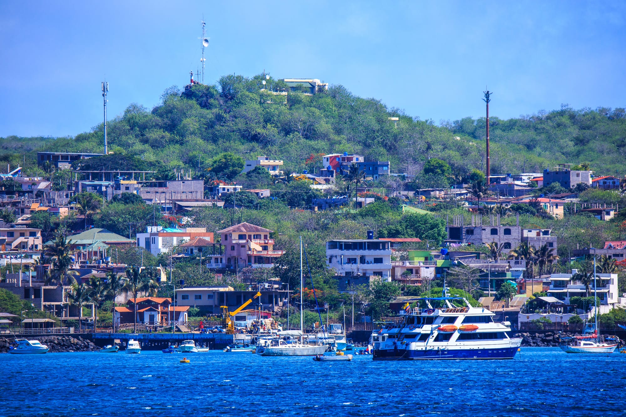
A cruise boat and small craft on deep blue water in front of a town of low houses climbing a green hill

The Galápagos Islands, Ecuador

Puerto Baquerizo Moreno

Puerto Baquerizo Moreno on San Cristóbal seen from its harbour in Shipwreck Bay. (Murray Foubister / Wikimedia Commons · CC BY-SA 2.0)

The capital of Galápagos province and the oldest settlement in the islands, on Shipwreck Bay on the south-west coast of San Cristóbal. A fishing town that grew with a 19th-century sugar estate, it now combines government offices, a university campus and a busy tourist waterfront, with sea lions sprawled on its beaches, benches and boats and an airport at the edge of town.

Neighbourhoods

  • The malecón and the centre
    • First-time visitors
    • Best for food
    • Close to the harbour

    The waterfront along Avenida Charles Darwin and the streets behind it, with restaurants, souvenir shops, tour agencies, the cathedral and the natural history museum. Sea lions lounge on the town beach, which is reserved for them, and on the decks of the boats anchored in the bay.

    Open in Maps
  • Playa Mann and the north-west of town
    • Beaches
    • Students
    • Nature walks

    A short walk west along the waterfront, the local beach of Playa Mann faces the Galápagos campus of the Universidad San Francisco de Quito. The interpretation centre and the trails to Frigatebird Hill and Punta Carola start just beyond it.

    Open in Maps
  • El Progreso
    • Highlands
    • Local life

    A farming village about 8 km inland on the paved road into the highlands, where the Hacienda Progreso sugar estate was founded in 1879. Today it is little more than a collection of farms, on the way to El Junco and the tortoise centre.

    Open in Maps

Things to do

In town

  • Interpretation Centre of the Galápagos National Parkmuseum

    A free national-park visitor centre established in 1988 on the western edge of town, with displays on the environment and history of the Galápagos and a loop walk of about an hour starting from it.

    Open in Maps
  • Cathedral of the Immaculate Conceptionlandmark

    The town-centre cathedral of the Apostolic Vicariate of Galápagos, whose murals set New Testament stories among the islands' own animals and plants.

    Open in Maps
  • Natural History Museummuseum

    A small museum in the heart of town, east of the Parque la Carolina and next to the Franciscan mission, with a statue of Charles Darwin at the entrance.

    Open in Maps

Beaches and walks

  • Cerro de las Tijeretas (Frigatebird Hill)viewpoint

    A hill about 1.6 km from town, reached by a trail and visited by two species of frigatebird, overlooking the bay where Darwin first came ashore in the Galápagos; the cove below is good for snorkelling.

    Open in Maps
  • Playa Mann and Punta Carolabeach

    The two public beaches north of town — Playa Mann a popular local beach, busy at weekends, and Punta Carola, reached on foot from the interpretation centre.

    Open in Maps
  • La Loberíabeach

    A rocky beach about 1 km beyond the airport, reached on a dirt path, with a large sea lion colony, marine iguanas and blue-footed boobies.

    Open in Maps

Short trips on San Cristóbal and by boat

  • El Juncopark

    A freshwater crater lake in the highlands of San Cristóbal, with a set of steep steps up from the parking area to the crater's edge.

    Open in Maps
  • Galapaguera de Cerro Coloradopark

    A reserve for the repopulation of San Cristóbal's giant tortoises, with a breeding centre, an interpretation centre and short trails, on the road between El Junco and Puerto Chino.

    Open in Maps
  • Kicker Rock (León Dormido)attraction

    The split remains of a lava cone off the island's west coast, rising about 140 m from the sea, visited only by boat with a guide for snorkelling and diving among turtles, sea lions and sharks.

    Open in Maps
  • San Cristóbal Airporttransit hub

    The town's airport, on the south-western end of the island within the urban area, with direct flights from the mainland.

    Open in Maps

Seasonal events

  • Cine Naval film festivalJuly

    A yearly festival of Ecuadorian and Latin American films at the Cine Naval, the town's only cinema, inside the naval station but open to the public.

Eat and drink

Long-standing places and food districts in Puerto Baquerizo Moreno. Hours, ratings and directions come from your maps app, always current.

San Cristóbal classics

  • Set mealsrestaurant

    Many small places serve the everyday set meal of soup, rice and chicken or fish.

    Open in Maps
  • Ceviche and lobsterrestaurant

    Ceviche of fish, shrimp or octopus, grilled catch from the town's fishing fleet and spiny lobster, langosta, grilled or in garlic.

    Open in Maps

Food districts and cafés

  • The malecónneighborhood

    The waterfront strip, where restaurants with English menus serve local and international food, and cafés make fresh batidos, milkshakes of tropical fruit.

    Open in Maps
  • Galápagos coffeecafe

    Coffee grown in the San Cristóbal highlands is sold vacuum-packed or in tins in the town's shops and cafés.

    Open in Maps

Experience Puerto Baquerizo Moreno

History

Puerto Baquerizo Moreno is the oldest settlement in the Galápagos. General José de Villamil founded it in the 1830s or 1840s, and it takes its name from Alfredo Baquerizo Moreno, the first Ecuadorian president to visit the islands while in office. Charles Darwin had landed on San Cristóbal in 1835, at the start of his five weeks in the archipelago with HMS Beagle, and Frigatebird Hill overlooks the bay where he first came ashore.

The town's early fortunes were tied to the Hacienda Progreso, founded in 1879 about 8 km inland at El Progreso. It ran a large sugar refinery, as well as leather and oil production, under harsh conditions, and two assassinations took place there; the estate's owner, Manuel Cobos, was killed by his workers in 1904. The settlement lived on as a fishing port and is now the capital of Galápagos province, created in 1973; the governor lives in a grey stone building that also houses the naval headquarters.

Conservation and tourism shaped the late 20th century. The national park's interpretation centre opened in 1988, local people founded the Albatross Foundation in 1993 to teach young people about protecting the islands, and a Charles Darwin Research substation opened in the town in 1998. In June 2019 the Ecuadorian government's permission for the US military to use the airport as a base caused widespread outcry.

Culture & Customs

Locals often call the town simply Cristóbal, after the island. It has a stronger everyday feel than Puerto Ayora: fishermen, naval personnel, civil servants and students live alongside the tourist trade, and the cathedral, the Franciscan mission and the government offices sit among the shops of the centre. The murals of the cathedral, which place New Testament scenes among Galápagos animals and plants, sum up the town's double identity.

Sea lions are the town's emblem. They sleep on the beaches, the docks, the park benches and the decks of anchored boats, a small beach in the centre is reserved for them, and residents regard them with real affection. Conservation is part of local culture, from the Albatross Foundation's schools work to the university's research.

The Galápagos campus of the Universidad San Francisco de Quito brings students from Ecuador and abroad, and surfing is a local passion, with waves at Tongo Reef and other breaks around the island. Every July the Cine Naval, the town's only cinema, holds a festival of Ecuadorian and Latin American films. The town is twinned with Chapel Hill in North Carolina.

Daily Life

About 7,300 people lived in Puerto Baquerizo Moreno at the 2022 census, making it the second-largest town in the Galápagos after Puerto Ayora. As capital of Galápagos province and of San Cristóbal canton, it is home to the governor, the provincial offices, and the headquarters of the navy and the national police in the islands.

Fishing is a major part of the economy: in 2014 some 520 fishermen worked from the port with 212 boats. Tourism is growing along the waterfront, with hotels, restaurants, souvenir shops and tour offices, and many boat owners find that carrying visitors pays better than fishing. Farming is marginal, because water is scarce; the town's drinking water is piped from a lake near El Progreso, which also irrigates nearby land.

Days start early at the port and on the boats. Most streets in the centre are paved, the electricity supply is continuous, and the town has a hospital and a university campus. Invasive plants such as the quinine tree, Cuban cedar and elephant grass spread through the highlands above town, one of several conservation problems residents live with.

Food

Most food arrives by cargo ship from Guayaquil, so cooking on San Cristóbal is mainland Ecuadorian food shaped by the sea. The town's fishing fleet supplies grilled fish, ceviche of fish, shrimp or octopus, and fish in coconut sauce, and spiny lobster, langosta, is served grilled or in garlic.

For everyday eating, many small restaurants serve a set meal of soup, rice and chicken, and the restaurants along the malecón offer local and international dishes with English menus. Fresh fruit batidos, milkshakes, are a favourite in the cafés, and fresh juices are sold everywhere.

The highlands around El Progreso grow coffee, bananas, papaya and citrus, and Galápagos coffee from the island is sold in town in vacuum packs and tins, a popular thing to take home. Beer mostly comes from the mainland, though small local breweries have appeared in the islands. Lobster and fish are the main catch of the islands' fishing fleets, and fishing remains the town's other great livelihood after tourism.

Planning tools

Budget

Prices are well above mainland levels, since most food and goods are shipped from Guayaquil, but the town is a little quieter and simpler than Puerto Ayora. Many sights near town — the interpretation centre, Frigatebird Hill, the beaches and La Lobería — are free, while boat trips to Kicker Rock, dives and taxi tours of the highlands add most of the cost.

Daily Budget Midrange
USD 200–500 (hotel and daily boat tours); cruises from about USD 350 per day upwards
Daily Budget Shoestring
USD 80–130 (guesthouse, set meals, free beaches and trails, excluding flights and park fee)

Bring cash for the park fee and small purchases; card machines and cash machines are limited, and one bank machine may not accept every card.

Best Time to Visit

Any time of year. December to May is warmer and sunnier, with brief heavy showers and calmer, warmer seas; June to November is cooler, with garúa drizzle, overcast skies, constant winds and plankton-rich water. Surfers come for the waves at Tongo Reef from December to February.

Suggested Number of Days

Two or three days cover the town, the walks and beaches near it and a boat trip. Four or five allow the highlands and a second boat trip as well. Weather and sea conditions can cancel trips, so a spare day helps when combining San Cristóbal with other islands.

First Visit
2–3 days
With Surroundings
4–5 days

Transportation

The town is small: walking from one end to the other takes 20 to 30 minutes, and the airport is within reach on foot. Pick-up truck taxis cover the town for a small flat fare and run to El Progreso, El Junco, the Galapaguera and Puerto Chino at fares set by the local government. A single road crosses the island to Puerto Chino, and bicycles can be rented.

Speedboats to Puerto Ayora take about two hours and are often rough; take seasickness tablets beforehand.

Airport & Station Connections

San Cristóbal Airport lies within the urban area at the south-western end of the island, a short taxi ride or walk from the centre. Avianca and LATAM fly there from Guayaquil and Quito, and small planes link it with Isabela, Santa Cruz and Baltra. Public speedboats run twice daily to and from Puerto Ayora, a crossing of about two hours.

Walkability

Very walkable. The centre has paved streets, the waterfront runs the length of town, and trails lead on foot to the interpretation centre, Frigatebird Hill, Punta Carola and La Lobería. Paths beyond town are rocky and uneven, so proper footwear is needed, and there is little shade.

Safety

The islands are far calmer than mainland Ecuador, with little violent crime, although petty theft occurs in the towns and drug-trafficking routes pass through the surrounding ocean. Most risks are natural: strong sun, waves and currents at the snorkelling sites, deep water at Kicker Rock and bull sea lions on the beaches. The town has a hospital.

Use reef-safe sunscreen and cover up, snorkel with a guide or buddy, keep a distance from wildlife and follow biosecurity checks on arrival. Snorkel at Tijeretas and Kicker Rock only in calm conditions, and keep about two metres from sea lions. Check current official travel advice before travelling.

Climate

Dry and mild for the equator, because of the cold Humboldt Current. The monthly mean is about 24°C, and annual rainfall is low and varies greatly from year to year, falling mostly between December and May.

Summer
December–May, the warm wet season: the warmest month, February, averages about 26.5°C, with sunshine and brief, intense showers
Winter
June–November, the cool garúa season: overcast and drizzly, with September the coolest month at about 22°C on average

Local Customs

Puerto Baquerizo Moreno is a working town as much as a tourist one, home to the provincial government, the navy and a fishing fleet. Sea lions are treated with affection: one town beach is reserved for them. Most visitor sites beyond town require a licensed guide, and park rules on distance from wildlife are taken seriously.

Never buy handicrafts made from the islands' natural materials, which Galápagos law forbids, and never feed or touch sea lions.

Common Payment Methods

Ecuador uses the US dollar. Cards are accepted in most larger hotels, restaurants and agencies, but cash is preferred in small shops and for taxis. Banco del Pacífico has a cash machine in town, and there is another at the airport; foreign cards are not always accepted, so arriving with cash is wise.