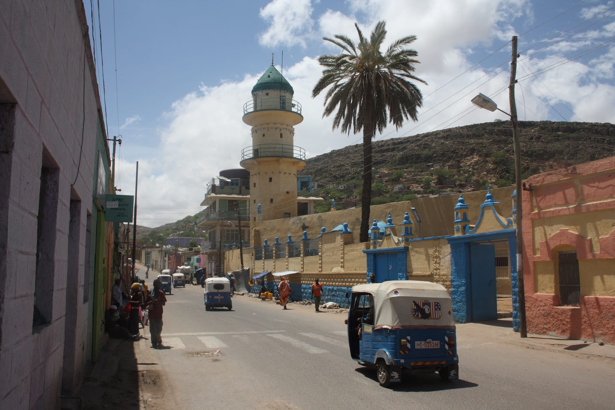
A street in Dire Dawa with blue three-wheeled taxis, a palm tree and a mosque with a cream minaret below a bare hillside

Addis Ababa, Oromia, Harar & the East, Ethiopia

Dire Dawa

A street in Dire Dawa, with the minaret of the Grand Jumaa Mosque above the blue three-wheeled taxis that serve the city. (Arne Hückelheim / Wikimedia Commons · CC BY-SA 3.0)

A lowland city in eastern Ethiopia created in 1902 when the railway from Djibouti stopped short of Harar and built a new town on the plain instead. It grew in two halves — a French-planned grid of straight streets and an older market quarter across a dry riverbed — and is a chartered city, a trading centre and the air gateway to Harar.

Neighbourhoods

  • Kezira
    • First-time visitors
    • Historic district
    • Cafés

    The planned town laid out beside the railway in the early 1900s, a grid of straight streets and shaded squares with French-influenced arcaded buildings, the old station, the main hotels and most government offices.

    Open in Maps
  • Megala
    • Markets
    • Local life

    The older trading quarter on the far side of the Dechatu riverbed, denser and busier than Kezira, built around the market and the mosques, with lanes of workshops, tea houses and khat stalls.

    Open in Maps
  • The station quarter
    • Historic district
    • Close to public transport

    The area around the original Ethio-Djibouti railway station, with its yellow station building, goods sheds and railway housing — the reason the city exists, and still the easiest place to see it.

    Open in Maps
  • Sabian
    • Quiet and residential
    • Local life

    A spread-out residential district on the northern edge of the city, growing outwards with newer housing, small shops and roads towards the airport and the Djibouti highway.

    Open in Maps

Things to do

The railway city

  • The old railway stationlandmark

    The yellow station building of the Franco-Ethiopian line, standing at the head of the avenue that the planned town was laid out around.

    Open in Maps
  • Kezira's colonial streetsneighborhood

    Straight avenues of arcaded shopfronts and shuttered houses built for the railway company's staff and for the French, Greek, Armenian, other European and Arab merchants who followed them in the early 20th century.

    Open in Maps
  • Dire Dawa International Airporttransit hub

    The city's airport, about 5 kilometres north-west of the centre, with flights from Addis Ababa, and the way most visitors to Harar arrive in the east.

    Open in Maps

Markets and mosques

  • The main marketmarket

    The city's principal market, on the Megala side of the riverbed, spread over lanes and yards, where highland produce, lowland fruit, cloth, spices and the afternoon khat trade meet.

    Open in Maps
  • Grand Jumaa Mosquelandmark

    The principal Friday mosque of the city, its minaret a landmark over the low roofs of the Megala side.

    Open in Maps
  • The railway workshopslandmark

    Sheds and workshops behind the old station, built to maintain the rolling stock of the Franco-Ethiopian line, with old wagons standing on the sidings.

    Open in Maps
  • The Dechatu riverbedattraction

    The wide sandy bed that divides the two halves of the city, dry for most of the year and crossed on foot, but capable of dangerous flash floods after heavy rain in the hills.

    Open in Maps

Short trips from the city

  • Hararattraction

    The walled Muslim city on its ridge at 1,885 metres, about 50 kilometres by road to the south-east, a UNESCO World Heritage Site of narrow lanes, mosques and painted houses; Dire Dawa was founded in 1902 as New Harar after the railway failed to reach it.

    Open in Maps
  • Babile Elephant Sanctuarypark

    A wildlife sanctuary of acacia woodland and scrub in Babile district, about 40 kilometres south of Harar, holding an isolated elephant population and usually reached on a long day out.

    Open in Maps
  • Laga Odaattraction

    A prehistoric site a few kilometres from the city which, with the nearby cave of Porc-Épic, has yielded rock paintings and Middle Stone Age artefacts showing the area was lived in by Mesolithic times.

    Open in Maps

Seasonal events

  • Eid al-Fitrvaries with the Islamic calendar

    The end of Ramadan, the largest public celebration in a mainly Muslim city, with morning prayers on open ground and visiting for the rest of the day.

  • Eid al-Adhavaries with the Islamic calendar

    The feast of sacrifice, marked with prayers, the slaughter of sheep and goats and meals shared among families and neighbours.

  • Meskellate September

    The Orthodox Finding of the True Cross, marked by the city's Christian minority with a bonfire and procession.

  • TimkatJanuary

    Orthodox Epiphany, when tabots are carried from the churches of Kezira in procession and crowds are blessed with water.

Eat and drink

Long-standing places and food districts in Dire Dawa. Hours, ratings and directions come from your maps app, always current.

Dire Dawa classics

  • Lowland grills and stewsrestaurant

    Kitchens in the planned town serving grilled goat and beef tibs, stews with injera, and rice and pasta dishes that show the city's Somali, Arab and Italian trading history.

    Open in Maps
  • Tea and juice housescafe

    Spiced tea with milk, macchiato and layered fruit juices of mango, avocado and papaya, drunk through the hottest part of the day.

    Open in Maps

Markets and streets

  • The main marketmarket

    Bananas, mangoes and papaya from the irrigated valleys, grain and vegetables from the highlands, spices, and bundles of khat sold from mid-morning.

    Open in Maps
  • Megala eating housesneighborhood

    Small places around the market serving sambusa, ful with bread at breakfast, camel and goat meat, and canjeero, the thin fermented pancake of the Somali lowlands.

    Open in Maps

Experience Dire Dawa

History

Dire Dawa was made by a railway. The Franco-Ethiopian line from the port of Djibouti could not climb the escarpment to Harar without great cost, and in a letter of November 1896 Menelik II accepted that the first section might end at a village at the foot of the mountains instead. The line reached that spot on 24 December 1902, the date taken as the city's foundation, and the new town was known at first as New Harar. Its planned half, Kezira or Gezira, was drawn as a grid of straight streets with squares, a station, workshops and housing for the company's staff — a French colonial town plan in an uncolonised country.

Trade followed at once. French, Greek, Armenian, other European and Arab merchants opened shops, hotels and small industries beside Ethiopian traders, and the market quarter of Megala, settled mainly by Somali and Arab traders, grew on the opposite bank of the Dechatu, the seasonal river whose sandy bed still divides the city. Coffee, hides and khat went down the line to the coast; manufactured goods came up. Harar, robbed of its through traffic, became the smaller place. The line reached Addis Ababa in 1917 and Dire Dawa became its most important intermediate town.

Italian occupation from 1936 to 1941 added buildings and a garrison, and the town stayed under British military administration until 1947. Industry followed: a cement works, textile mills and food processing. When the Somali Region was established in 1993 it wanted Dire Dawa as its capital, Oromia opposed the claim, and the federal government took the city under its own jurisdiction; a charter approved by parliament in 2004 made it one of Ethiopia's two chartered cities, with Addis Ababa. In August 2006 the Dechatu and Gorro rivers overflowed: about 200 people were reported dead and thousands displaced. The standard-gauge railway to Djibouti, opened for commercial service in 2018, passes the city from a station outside the old centre.

Culture & Customs

Dire Dawa is a mixing point rather than the city of one people. Oromo, Somali, Amhara, Harari, Gurage and Argobba residents live side by side, and Afaan Oromo, Somali, Amharic, Harari and Arabic are all heard in the markets; the city's administration works in more than one language. Most residents are Muslim, with a substantial Orthodox and Protestant Christian minority, so both the Islamic and the Ethiopian religious calendars are publicly marked, and Eid and Meskel are both occasions in the same streets.

The two halves of the city have different characters. Kezira keeps the habits of the railway town — pavement cafés, macchiato, wide shaded streets, an evening promenade — while Megala is denser, louder and organised around the market and the mosques. Khat ties them together: it arrives from the hills around Harar in the morning, is sold through the middle of the day and chewed through the afternoon in groups of friends or colleagues, an institution of social life across the east.

Music and dress reflect the mixture, with Somali and Oromo songs, Harari celebrations and Ethiopian highland music heard in the same bars. The city's long-standing trading families, some of foreign descent, and its railway workforce gave it an outward-looking reputation within Ethiopia, and residents are conscious of belonging to a chartered city that stands apart from the regions around it.

Daily Life

The 2007 census counted 341,834 people in the Dire Dawa chartered city, which includes rural districts as well as the built-up area, and the official projection for 2015 was about 440,000, of whom some 277,000 lived in the city proper. The economy rests on trade with Djibouti and the Somali lowlands, transport and logistics, the market, and a cluster of older industries including cement, textiles and food processing, with an industrial park built on the edge of the city in the last decade.

Work starts early to beat the heat, and the middle of the day is quiet, with shops shuttered and the streets left to the bajaj drivers. The market is busiest in the morning; by mid-afternoon the khat stalls have taken over. Evening brings people back onto the avenues of Kezira when the temperature drops.

Water is the persistent difficulty: supply is limited in a dry lowland city that has grown quickly, while the Dechatu can flood violently when rain falls on the hills above, as it did in 2006. Unemployment among young people, the cost of living and the informal cross-border trade that supports many households are the other recurring concerns. Housing spreads outward in low compounds and newer condominium blocks, and the rural parts of the administration farm with irrigation from the valleys.

Food

The kitchens of Dire Dawa draw on three directions at once: the Ethiopian highlands, the Somali lowlands and the Red Sea trade. Injera with wat is standard, served with shiro, lentils and greens on fasting days and with beef or goat stewed in berbere otherwise, and tibs — cubes of meat sautéed with onion and chilli — is the usual order in the evening. Somali and Arab habits bring rice cooked with spiced meat, pasta, camel meat and camel milk, and canjeero, a thinner and softer fermented pancake than injera, eaten at breakfast.

Sambusa, the fried triangular pastry filled with lentils or minced meat, is sold on every corner in the afternoon, and ful — broad beans crushed with oil, chilli and sometimes egg, scooped up with bread — is the breakfast of the market quarter. The irrigated valleys near the city supply mangoes, papaya, bananas and guavas cheaply, which appear as thick layered juices in the tea houses, a drink the east is known for.

Coffee comes down from the Harar hills, among the most valued Arabica in the country, and is brewed in the jebena or drunk as macchiato in the old town's cafés; the husk infusion favoured in Harar is drunk here too. Spiced tea with milk, sweetened heavily, is the other constant, and bottled beer is sold in Kezira although many residents do not drink.

Planning tools

Budget

Dire Dawa is inexpensive. Hotels in Kezira are modest and cheap by capital standards, local meals cost little, and the three-wheeled taxis that serve the city are the cheapest urban transport in Ethiopia. The main outlays are the flight from Addis Ababa and a hired car for Harar or the country beyond it.

Daily Budget Midrange
USD 70–150 (better hotel, restaurant meals, a car with a driver for Harar and the surrounding area)
Daily Budget Shoestring
USD 20–40 (basic hotel, local eateries, shared bajaj taxis)

Carry cash in birr, agree driver and hotel rates in advance, and expect cards to work only in a few larger hotels.

Best Time to Visit

November to February is the least punishing period, when days are hot but manageable and nights cool. March to May is the hottest stretch, regularly above 35°C. Rain comes in short spells around March and April and again between July and September, and heavy rain in the hills can send flash floods down the Dechatu riverbed.

Suggested Number of Days

A day is enough for the two halves of the city and its markets. Two or three make sense for anyone using it as a base for the walled city to the south-east and the dry country beyond, which is how most visitors treat it.

First Visit
1 day
With Surroundings
2–3 days

Transportation

Blue three-wheeled bajaj taxis are everywhere and are how almost everyone moves around, on fixed shared routes or hired whole. Minibuses run to Harar in about an hour over the escarpment, and buses leave for Addis Ababa and Jijiga. The standard-gauge Addis Ababa–Djibouti railway, opened for commercial service in 2018, serves the city from a station about 10 kilometres north-west of the centre near Melka Jebdu, not from the old one.

Agree the fare before getting into a bajaj if hiring it privately, and allow extra time to reach the station or airport, both of which are outside the built-up centre.

Airport & Station Connections

Dire Dawa International Airport lies about 5 kilometres north-west of the centre and has flights from Addis Ababa; it is the usual way to reach Harar. Buses from the capital take a long day on the eastern highway, and the electric standard-gauge railway to Djibouti serves the city from a station about 10 kilometres north-west of the centre.

Walkability

Kezira is flat, shaded in places and laid out on a grid, which makes it easy to walk, and the market quarter across the riverbed is a short walk from it. Heat limits how much walking is comfortable between about eleven and four, and pavements are uneven or missing outside the planned centre, so most people take a bajaj for anything longer than a few blocks.

Safety

Dire Dawa and the road to Harar are generally manageable, with petty theft and pickpocketing around the markets, the bus station and the riverbed the main risks. Its position near the Oromia–Somali boundary has meant occasional unrest, and parts of the Somali Region towards the Somalia border are covered by government advice against travel.

Check current advisories closely and route around conflict-affected regions, travel the Danakil and remote parks only with a licensed operator and escort, and avoid political demonstrations. Check current official travel advice before travelling.

Climate

Hot and semi-arid on the eastern plain, far warmer than the highlands and warmer than Harar on its ridge at 1,885 metres. Rain falls in two short seasons and averages about 670 millimetres a year, and the heat is dry rather than humid.

Summer
hot, often 32–36°C by day, with short rains between July and September
Winter
warm and dry, around 28–32°C by day with mild nights

Local Customs

The city is largely Muslim, and dress is modest in the market quarter, though the planned town is mixed and more relaxed; alcohol is sold openly in Kezira. Somali, Oromo, Amharic, Harari and Arabic are all heard. Afternoons slow as men gather to chew khat, the stimulant leaf that dominates local trade, and business is easier conducted in the morning.

Ask before photographing people, particularly at the market and around mosques, and avoid photographing the airport, the railway installations and police.

Common Payment Methods

The currency is the Ethiopian birr, and cash is used for almost everything. Bank branches and ATMs are common in Kezira but can run out of notes, and cards are accepted only at a few larger hotels. Clean US dollar notes are changed at banks.