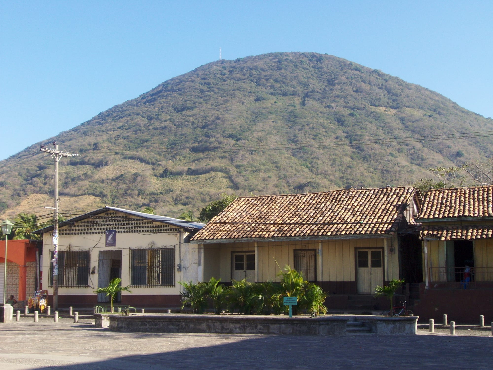
Tile-roofed old houses on the paved square of Amapala, with the green cone of the El Tigre volcano rising behind under a clear sky

Tegucigalpa, the Centre & the Pacific South, Honduras

Amapala

The volcanic cone of El Tigre seen from the main square of Amapala. (Alfredobi / Wikimedia Commons · Public domain)

A small port town on El Tigre, a volcanic island in the Gulf of Fonseca that Honduras shares with El Salvador and Nicaragua. For much of the nineteenth and twentieth centuries it was the country's main Pacific port, until San Lorenzo on the mainland replaced it; today it is a quiet fishing town of old wooden buildings, reached by a short boat ride from Coyolito.

Neighbourhoods

  • Amapala town
    • First-time visitors
    • Historic district

    The island's main town, around the dock, the main square and a waterfront park, with a few old buildings from its years of wealth as a port. Street food is sold a couple of blocks up from the docks, and the town comes to life at weekends and holidays.

    Open in Maps
  • Playa Burro and the north shore
    • Beaches
    • Quiet

    A beach village on the north of the island, with its own boats from Coyolito and the start of one of the trails to the summit. The water is calm and the views across the gulf to the neighbouring islands are the main draw.

    Open in Maps
  • The island road and its villages
    • Local life
    • Walking

    An 18 km road circles the island through small villages named after the beaches nearby. Many people here are poor, especially on the eastern side, and life revolves around fishing.

    Open in Maps

Things to do

The island and its views

  • Cerro El Tigretrail

    The volcanic cone that forms the island, the southernmost volcano in Honduras; unmarked trails climb to a disused antenna and the ruins of a base used by Nicaraguan rebels, with wide views over the Honduran coast.

    Open in Maps
  • The island roadtrail

    An 18 km road around the island with little change in height, passing fishing villages and viewpoints over the gulf on the southern side.

    Open in Maps
  • Isla Zacate Grandeviewpoint

    A volcanic island close by, part of the municipality of Amapala and home to several of its villages.

    Open in Maps

Beaches and the town

  • Playa Burrobeach

    A calm beach on the north of the island, with a mix of volcanic and ordinary sand, simple food stalls and views across the gulf.

    Open in Maps
  • The old port and main squarelandmark

    The square, church and old buildings near the dock that recall the town's years as the country's Pacific port, with the volcano rising behind.

    Open in Maps

Short trips from the island

  • San Lorenzoattraction

    The mainland town on the Pan-American Highway that replaced Amapala as the main Honduran port on the Pacific.

    Open in Maps

Eat and drink

Long-standing places and food districts in Amapala. Hours, ratings and directions come from your maps app, always current.

Amapala classics

  • Street food near the docksmarket

    Stalls a couple of blocks up from the docks selling simple local food.

    Open in Maps
  • Seafood comedoresrestaurant

    Small family restaurants in the town and beach villages serving the fish and shellfish of the gulf.

    Open in Maps

Experience Amapala

History

The island of El Tigre takes its name, according to one local account, from the pirates said to have used it in the sixteenth century, whose ferocity earned the island the name "Cerro del Tigre". The town of Amapala was founded in 1838, and thanks to a natural deep-water channel it became, despite its lack of modern infrastructure, the main Honduran port on the Pacific. The port was opened and declared free in 1868, and through the nineteenth century it exported large quantities of gold, silver and other ores, although its growth was held back by the long delay in building a railway across the country to Puerto Cortés.

German immigrants played a large part in its trade in the late nineteenth century, and the town grew wealthy. Politics passed through it too: in 1876 Marco Aurelio Soto took provisional charge of the government at Amapala, and in 1895 it was named capital of the short-lived Greater Republic of Central America, an attempt to reunite El Salvador, Honduras and Nicaragua that broke apart in 1898.

The port's importance faded as San Lorenzo, on the mainland, took its trade, and by the mid-1970s it had been replaced. During a civil war in Nicaragua, Honduras allowed Nicaraguan rebels to set up a base on the island's summit, and its ruins remain. In 1992 a chamber of the International Court of Justice ruled on the long dispute over the gulf, deciding that the three countries share its waters and awarding El Tigre to Honduras.

Culture & Customs

Amapala is a small fishing town whose identity comes from the sea and from its past as a port. The old buildings around the square and the dock are reminders of its prosperous decades, when the town was briefly a seat of government. Today the island is a quiet place of fishing boats, tuk-tuks and beach villages named after the shores beside them.

The gulf is a shared space: Honduras, El Salvador and Nicaragua all have coastlines on it, and the views from the island take in the neighbouring islands. Visitors from abroad are few, and the island's character is that of a weekend retreat for families from Tegucigalpa and the south, who fill the beaches and seafood restaurants on holidays and leave the island almost empty during the week.

Life follows the rhythm of the tide, the heat and the church. A Honduran Navy base south of the town adds a small official presence to a place otherwise run at the pace of a village.

Daily Life

The municipality of Amapala, which covers El Tigre, the island of Zacate Grande and a scatter of islets, had 12,250 people at the 2013 census. The town of Amapala is the island's main settlement, and several villages lie around the coast and on Zacate Grande.

Most residents work as fishermen, and only a few hundred had formal jobs in 2013. Unemployment is high and much of the population is poor, especially in the villages on the eastern side of El Tigre, although a government programme has given many poor families small new houses. Tourism, mostly from Honduras itself, brings some income at weekends and during holidays.

Everyday life depends on the boats to Coyolito for supplies, school and work on the mainland, and on tuk-tuks for getting around the island. Days start early, before the heat, and evenings are spent outside in the square or in the waterfront park, where the kiosk and the grass are shared by residents and the occasional camper.

Food

Amapala eats from the Gulf of Fonseca. Fish and shellfish, caught locally or farmed around the gulf, are the basis of most meals, often served fried whole or with lime and chilli, alongside rice, beans, fried plantain and tortillas. Shrimp farmed around the gulf are one of the south's main products.

Simple stalls a couple of blocks up from the docks sell street food, and beach villages such as Playa Burro have small places serving snacks, fried fish and fruit drinks such as fresco de sandía, a fresh watermelon drink. The baleada, a flour tortilla folded over refried beans, cream and hard cheese, is the everyday snack here as across Honduras.

The heat is fought with fresh fruit drinks, horchata and tamarind water, and with sweet melons from the Choluteca plain on the mainland, one of the region's main exports. A meal of fried fish eaten with a view of the volcanoes across the gulf is the island's simple pleasure.

Planning tools

Budget

Getting to Amapala is cheap: a bus to the Coyolito turn-off, a local bus or minibus to the jetty and a short boat crossing. Rooms on the island are aimed mainly at weekend visitors from the capital and cost more than the town's simple setting suggests; food and tuk-tuk rides cost little.

Daily Budget Midrange
USD 60–110 (better room, seafood meals, a hired boat or guide)
Daily Budget Shoestring
USD 25–40 (simple room, street food, buses, boats and tuk-tuks)

Bring enough cash in small notes from the mainland; services on the island are limited.

Best Time to Visit

November to February, after the rains and before the worst of the heat, is the most comfortable time. March and April are very hot on the Pacific coast, and the rainy season runs roughly from May to October. Weekdays are almost empty of visitors; weekends and holidays bring families from Tegucigalpa.

Suggested Number of Days

A night or two is enough to see the town, the beaches and the view from the summit. Many travellers use the island as a stopover between the borders of El Salvador and Nicaragua; boat trips around the gulf add time.

First Visit
1–2 days
With Surroundings
2–3 days

Transportation

Tuk-tuks are almost the only transport on the island; they charge per person and pick up other passengers along the way. The 18 km road around the island is flat enough to walk or cycle. Boats link the island with the mainland jetty at Coyolito.

Hire a local guide for the climb to the summit, as the trails are unmarked.

Airport & Station Connections

Buses between Tegucigalpa or the El Salvador border and San Lorenzo stop at a junction north of San Lorenzo, from where buses run to the fishing village of Coyolito. Boats go frequently from Coyolito across to Amapala and to Playa Burro. Travellers crossing between El Salvador and Nicaragua often break the journey here.

Walkability

The town is small and easy to walk, and the island road is flat and quiet. Heat is the main obstacle: walks are best early in the morning or late in the afternoon, with plenty of water.

Safety

Honduras has had one of the highest homicide rates in the world, driven by gangs (MS-13 and Barrio 18) and drug trafficking, and San Pedro Sula and parts of Tegucigalpa remain dangerous. Amapala is much calmer, with petty theft the usual risk. The roads of the south carry heavy lorry traffic to the borders.

Travel to Coyolito by day, keep valuables out of sight on beaches and boats, and avoid deserted trails alone. Check current official travel advice before travelling.

Climate

Hot all year. The Pacific lowlands around the Gulf of Fonseca are among the hottest places in Honduras, passing 35 °C in March and April. Rain falls mainly between May and October; the dry months from November to April are hot and dusty.

Summer
rainy season May–October; across the Pacific south days are often over 33 °C
Winter
dry season November–April; hottest in March and April, when the region passes 35 °C

Local Customs

Amapala is a small, traditional fishing community where people greet each other and strangers on the street. Many residents are poor, and visitors walking around the island pass homes in difficult conditions; discretion and politeness are appreciated.

Ask before photographing people or their homes, dress modestly away from the beach, and greet with 'buenos días' or 'buenas tardes'.

Common Payment Methods

The currency is the Honduran lempira. Cash in small notes is needed for buses, boats, tuk-tuks and food on the island; it is best to bring enough from the mainland.