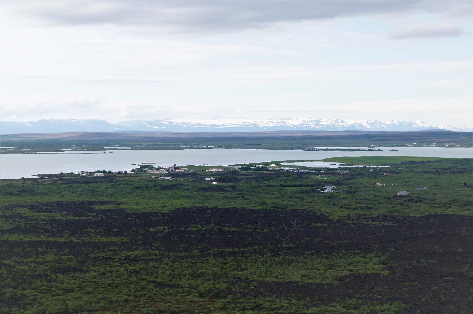
Dark lava fields and green scrub leading to the houses of Reykjahlíð on the shore of Lake Mývatn, with snowy mountains far beyond

North Iceland, Iceland

Reykjahlíð

Reykjahlíð on the shore of Lake Mývatn, seen from Hverfjall. (Alexander Grebenkov / Wikimedia Commons · CC BY 3.0)

A village of a few hundred people on the north-eastern shore of Lake Mývatn, 292 metres above sea level, the highest settlement of its kind in Iceland. Lava destroyed it in the Mývatn fires of 1729 but stopped at its church; today it is the base for the craters, lava formations, mud pots and geothermal baths of an area of active volcanism.

Neighbourhoods

  • Reykjahlíð village
    • First-time visitors
    • Close to public transport

    The main village on the north-eastern shore, with the church on its rise above the lava, a fuel station with a grocery shop, the campsite uphill from the church, a small airport for sightseeing flights and the starting point of the trail to Hverfjall and Dimmuborgir.

    Open in Maps
  • Skútustaðir
    • Quiet and residential
    • Walks

    The smaller settlement on the southern shore, with basic services, the visitor centre and trails through the pseudocraters that line the lake.

    Open in Maps

Things to do

Around the village

  • Reykjahlíð churchlandmark

    The church on higher ground where, by local tradition, the lava of 1729 stopped in answer to the priest's prayers; the present building dates from 1972.

    Open in Maps
  • Lake Mývatnpark

    A shallow lake created by an eruption 2,300 years ago, with wetlands that draw huge numbers of nesting ducks, protected with the river Laxá as a nature conservation area.

    Open in Maps
  • Mývatn Nature Bathsattraction

    Geothermal baths opened in 2004, with a large outdoor lagoon of mineral-rich water and natural steam baths.

    Open in Maps
  • Grjótagjáattraction

    A small lava cave with a thermal spring inside, a bathing place until the eruptions of 1975–84 heated the water above 50°C; now for looking, not swimming.

    Open in Maps

Craters and lava

  • Hverfjallviewpoint

    A tephra cone about a kilometre across that erupted some 2,500 years ago; the rim, reached only by two marked paths, looks over the lake and the village.

    Open in Maps
  • Dimmuborgirtrail

    The 'dark castles', a large field of lava pillars, arches and caves east of the lake with marked trails through it.

    Open in Maps
  • Skútustaðir pseudocratersviewpoint

    Clusters of rootless cones on the south shore, formed when lava flowed over wet ground and steam blasted through it, with trails explaining the geology.

    Open in Maps
  • Námaskarð mud potsattraction

    Bubbling mud pools, steaming vents and sulphur springs by the low Námafjall ridge, about 6 kilometres from the village on the road towards Egilsstaðir.

    Open in Maps
  • Kraflalandmark

    A volcanic caldera about 10 kilometres across near the lake, whose fissures erupted in the Krafla fires of 1975–84 and still steam, with the explosion crater of Víti and a geothermal power station.

    Open in Maps

Short trips from the village

  • Dettifosslandmark

    The waterfall 100 metres wide and 44 metres high on the Jökulsá á Fjöllum, reputed to be the second most powerful in Europe after the Rhine Falls.

    Open in Maps
  • Goðafosslandmark

    The 'waterfall of the gods' on the Ring Road, where the Skjálfandafljót falls 12 metres over a width of 30 metres.

    Open in Maps
  • Húsavíkattraction

    The harbour town on Skjálfandi bay known for whale watching, with its wooden church of 1907, reached by bus from the village.

    Open in Maps

Seasonal events

  • Mývatn MarathonSummer

    A marathon run around the lake each summer since 2000.

Eat and drink

Long-standing places and food districts in Reykjahlíð. Hours, ratings and directions come from your maps app, always current.

Mývatn classics

  • Hverabrauðmarket

    A molasses bread slow-baked for 24 hours underground by geothermal heat, sold around the lake.

    Open in Maps
  • Smoked troutmarket

    The local smoked trout, famous in Iceland for its taste, sold in most shops around the lake.

    Open in Maps
  • Vogafjós Cowshed Cafécafe

    A café just south of the village in the same building as a working dairy farm, with a glass wall between visitors and the cows.

    Open in Maps

Experience Reykjahlíð

History

Mývatn was made by fire. The lake itself was created by a large basaltic lava eruption about 2,300 years ago, and the landscape around Reykjahlíð — the tephra ring of Hverfjall, the lava pillars of Dimmuborgir, the pseudocraters of the south shore — is young by any geological standard.

In the eruptions of 1724–1729, the Mývatn fires, lava from the Krafla area overran the village and destroyed it. The people were saved when the flow stopped just short of the church on its higher ground, by tradition in answer to the prayers of the priest. The church still stands on that spot, though the present building dates from 1972.

The 20th century brought industry and conflict. In 1970, in a dispute over hydroelectric development of the Laxá, people of the Mývatn district blew up a dam at Miðkvísl, at the head of the river, and from 1975 to 1984 the Krafla fissures erupted nine times, laying fresh lava and heating the water in the Grjótagjá cave beyond bathing temperature. A plant extracting diatomite from the lake bed was a mainstay of the local economy until it shut in 2004. That same year, on 30 June, the Mývatn Nature Baths opened, and the village has since turned to tourism, with hotels and tours increasingly open through the winter.

Culture & Customs

Life around Mývatn has long been bound to the lake. Farmers collect duck eggs by a rule that leaves at least four in every nest, and the Laxá is known for its rich fishing for brown trout and Atlantic salmon. The ground's own heat bakes the local bread.

Folklore is attached to the lava: the thirteen Yule Lads of Icelandic tradition are said to live in Dimmuborgir with their mother Grýla and her husband Leppalúði. The cave of Grjótagjá has its own stories — an 18th-century outlaw, Jón Markússon, is said to have lived and bathed there — and it was used as a filming location for Game of Thrones.

The district's people live in a scattering of farms and two small villages, and many more arrive each summer to work in tourism. Summer evenings bring locals out for football, and the village keeps a nine-hole golf course. Since 2000 a marathon around the lake has been run each summer, and in winter the frozen lake becomes a playground for ice activities.

Daily Life

Reykjahlíð had 227 inhabitants in 2021. It is the seat of the municipality of Þingeyjarsveit and the main service point of the lake district, whose permanent population is swelled every summer by seasonal workers.

Tourism is now the mainstay of the economy. Farming continues, including dairying, and the area's geothermal energy is put to work at the Krafla power station and the Bjarnarflag station near Námafjall, one of the oldest geothermal stations in the country. The closure of the diatomite plant in 2004 ended what had been a mainstay of the local economy.

The year has two rhythms. In summer the village fills with visitors, buses and campers, the midges rise from the lake and the evenings stay light. In winter the population shrinks back, much of the lake freezes, and the long nights bring the northern lights season, from September to March, when some hotels and tours now stay open.

Food

Mývatn's best-known food is cooked by the earth. Hverabrauð, a molasses bread, is slow-baked for 24 hours underground by geothermal heat and sold around the lake. The method is an old one: Icelandic rye bread, rúgbrauð, was traditionally baked in pots or boxes set in holes dug near hot springs. The local smoked trout, famous in Iceland for its flavour, is in most shops, and the Laxá is known for its rich fishing for brown trout and Atlantic salmon.

Hangikjöt, the smoked lamb, is eaten here as throughout Iceland, and duck eggs are still harvested for home use on the local farms, by the old rule of leaving at least four in every nest. Skyr, the soft yogurt-like cheese eaten across Iceland, is a staple here too.

Eating out is limited to a handful of restaurants and cafés in Reykjahlíð and Skútustaðir, and the Vogafjós Cowshed Café. The grocery shop beside the fuel station is where most visitors stock up.

Planning tools

Budget

Beds around Mývatn are few and expensive in July and August, and restaurant choice is limited, so many visitors stay in Akureyri and come for the day. The village shop beside the fuel station covers self-catering. Most of the sights — Hverfjall, Dimmuborgir, the mud pots and Krafla — are natural sites; the Nature Baths, a smaller counterpart to the Blue Lagoon, are the main paid extra.

Daily Budget Midrange
USD 290–490 (guesthouse, one restaurant meal a day, a hire car, the Nature Baths)
Daily Budget Shoestring
USD 120–200 (campsite, supermarket food, buses or a shared hire car)

Book summer beds well ahead or base yourself in Akureyri; fill the tank in Reykjahlíð before heading east across the plateau.

Best Time to Visit

June to August for the long days, open roads to Krafla and Dettifoss, and the nesting ducks, though midges swarm in summer — a head net helps. September to March is the season for the northern lights, which the area round the lake is well placed to see, along with frozen lakes and snow-covered lava; some hotels and tours now stay open through the winter.

Suggested Number of Days

Two days cover the lake and the volcanic ground around it at an easy pace. Allow three or four to add the waterfalls and the coast to the north, and more in winter when weather can close the roads.

First Visit
2 days
With Surroundings
3–4 days

Transportation

There is little public transport around the lake, and a car is the easiest way to reach the sights; the road around Mývatn is about 36 kilometres, so cycling is a good option in summer. Buses link the village with Akureyri, Húsavík and Egilsstaðir. Sightseeing flights leave from the small local airport in summer.

In winter check road.is for the plateau east of Mývatn before setting out, and never drive past a closed-road barrier.

Airport & Station Connections

Reykjahlíð lies on the Ring Road east of Akureyri, reached through the Vaðlaheiðargöng toll tunnel; by bicycle it is a ride of about 90 kilometres. Buses run from Akureyri, Húsavík and Egilsstaðir. The nearest airport with scheduled flights from Reykjavík and seasonal international services is Akureyri.

Walkability

The village itself is small and easily walked, and a marked trail runs from Reykjahlíð over Hverfjall to Dimmuborgir. Other sights are spread around the lake and need a car, a bike or a long walk; paths in the lava and geothermal areas must be kept to.

Safety

Iceland has almost no violent crime and is one of the safest countries in the world. Around Mývatn the dangers are natural: at the mud pots and Krafla the crust beside the marked paths can be thin over boiling mud, cracks in the Dimmuborgir lava can hide deep crevices, the water in Grjótagjá is close to 50°C, and fog, high wind or a sudden storm can turn a fine day dangerous.

Stay on the boardwalks and marked paths in geothermal areas and at Dimmuborgir, do not bathe in Grjótagjá, and watch the weather, which changes quickly. Check current official travel advice before travelling.

Climate

A tundra climate bordering on subarctic: cool summers with crisp nights and very long, cold winters that are rarely severe. Temperatures have ranged from -31.2°C in March 1998 to 28.2°C in August 2004. Much of the lake freezes in winter, and the area is one of the sunniest in Iceland, with little precipitation.

Summer
cool with crisp nights — around Mývatn July averages 10.2°C
Winter
long and cold but rarely severe — around Mývatn January averages −0.2°C

Local Customs

Tipping is not practised in Iceland. Local farmers still collect duck eggs by an old rule that leaves at least four in every nest, and the nesting areas on the lake are closed during the breeding season. In summer the locals often play football in the evenings and usually welcome others to join.

Alcohol is sold in licensed bars and restaurants and the state Vínbúðin shops; the buying age is 20. Never drive off-road or walk into closed nesting areas.

Common Payment Methods

The currency is the Icelandic króna (ISK). Cards, including contactless, are used for everything, from the fuel pumps to the baths, and cash is almost never needed. A card with a PIN is useful for unattended fuel pumps.