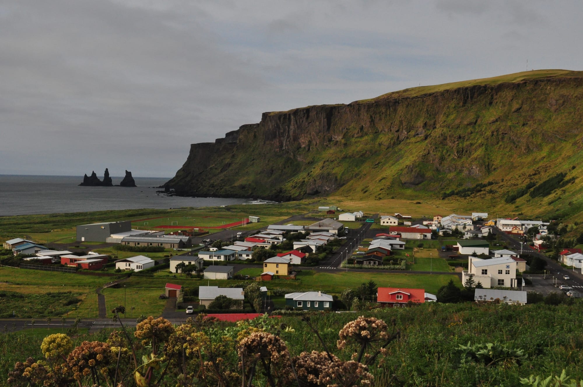
Houses of Vík spread across green flats below a steep cliff, with the dark Reynisdrangar sea stacks offshore

Reykjavík & the South, Iceland

Vík í Mýrdal

The village of Vík with the cliffs of Reynisfjall and the Reynisdrangar sea stacks. (Efrainlarrea / Wikimedia Commons · CC BY-SA 3.0)

Iceland's southernmost village, on the Ring Road about 180 kilometres by road south-east of Reykjavík, below the cliffs of Reynisfjall and the Mýrdalsjökull ice cap. It grew from a farmers' trading post of the 1880s and is now the main service centre of its stretch of coast, known for its black sand beach, the Reynisdrangar sea stacks and its watch on the Katla volcano.

Neighbourhoods

  • The village centre and the Ring Road
    • First-time visitors
    • Shops and services
    • Close to the bus

    The Ring Road runs straight through Vík, and along it and the streets just off it are the village's supermarket, the wool factory outlet, cafés, the bus stop and most places to stay. It is small enough to cross on foot in minutes.

    Open in Maps
  • The beach front
    • Beaches
    • Walks
    • Birdwatching

    South of the houses a broad strip of black basalt sand runs to the sea, with a monument to drowned seamen and views west to the Reynisdrangar stacks. The cliffs of Reynisfjall above the western end are a nesting place for puffins and other seabirds.

    Open in Maps
  • The church hill
    • Quiet and residential
    • Views

    Víkurkirkja, built in 1932–34, stands on a hill above the village, the place residents would head for if Katla erupts. The quiet residential streets below it look out over the rooftops to the sea.

    Open in Maps

Things to do

In the village

  • Vík beachbeach

    The black basalt sand beach in front of the village, counted by Islands Magazine in 1991 among the ten most beautiful beaches on Earth, with heavy surf and a memorial to lost seamen.

    Open in Maps
  • Víkurkirkjalandmark

    The village church of 1932–34 on its hill, thought to be one of the few public buildings that would be safe from a flood after a Katla eruption.

    Open in Maps
  • Brydebúðlandmark

    The oldest house in Vík, built in 1831 in the Westman Islands and moved here in 1895, a reminder of the village's trading-post beginnings.

    Open in Maps
  • Vík swimming poolattraction

    The village's outdoor pool, with a main pool and a warmer children's pool.

    Open in Maps

Coast and cliffs

  • Reynisdrangarviewpoint

    Basalt sea stacks under the mountain Reynisfjall, said in legend to be two trolls who were caught by daybreak while dragging a three-masted ship ashore and turned to stone.

    Open in Maps
  • Reynisfjarabeach

    The black sand beach on the far side of Reynisfjall, with the Hálsanefshellir cave and basalt columns, part of which collapsed in February 2026; its sneaker waves have killed several visitors.

    Open in Maps
  • Dyrhólaeyviewpoint

    A promontory with a great sea arch, reached by a steep switchback road, with puffins nesting on its cliffs in summer and views to Mýrdalsjökull and Reynisdrangar.

    Open in Maps
  • Hjörleifshöfðiviewpoint

    A 221-metre palagonite inselberg rising from the Mýrdalssandur outwash plain about 15 kilometres east of Vík, once an island in the Atlantic.

    Open in Maps

Short trips from the village

  • Sólheimajökullpark

    An outlet glacier of Mýrdalsjökull between the Katla and Eyjafjallajökull volcanoes, popular for its size and relative ease of access; in summer 2026 visitors were warned of unstable conditions on the glacier and its access routes as it melts.

    Open in Maps
  • Skógafossattraction

    A waterfall on the Skógá river pouring over the old sea cliff at Skógar, where there is also a museum.

    Open in Maps

Eat and drink

Long-standing places and food districts in Vík í Mýrdal. Hours, ratings and directions come from your maps app, always current.

Vík classics

  • Halldórskaffirestaurant

    A café-restaurant on Víkurbraut in the village centre.

    Open in Maps
  • Smiðjan breweryrestaurant

    A brewery in the village, one of the local businesses alongside the wool factory.

    Open in Maps

Self-catering

  • Krónan, Víkmarket

    The village supermarket, the place to stock up on food since there are no other supermarkets nearby.

    Open in Maps

Experience Vík í Mýrdal

History

For centuries there was no trading place on the south coast between Eyrarbakka and Papós. Fishing boats were rowed out from the beach at Vík, but with no harbour and heavy surf, going to sea here was hard and dangerous. In 1883 the farmers of Suður-Vík and Norður-Vík in Mýrdalur joined together to order goods from Britain and sell them from their homes, and that small venture turned into a proper trading post. A shop opened, sheep were slaughtered there, and in 1903 a two-storey trading house was built, with a second soon after.

A village slowly formed around the trade. By 1905 about 80 people lived in Vík in thirteen households, and schooling had begun around the turn of the century. Brydebúð, now the oldest house in the village, had been built in 1831 in the Westman Islands and was moved to Vík in 1895. A priest was based in the village from 1911 and a doctor from 1915 — though the physician and naturalist Sveinn Pálsson had already lived here from 1809 to 1833. The church on the hill was built between 1932 and 1934.

Vík has lived throughout with the volcano above it. Katla, beneath the Mýrdalsjökull ice cap, has at least twenty documented major eruptions and last erupted in 1918, longer ago than its usual quiet spell, which has led to speculation that another may come soon. A large eruption could melt enough ice to send a flood across the village, and residents know they would have to evacuate to the church, thought to be one of the few buildings that would survive. The Netflix series Katla, set in Vík, imagined the volcano's first eruption since 1918.

Culture & Customs

Vík's identity is bound up with the sea and the mountain. The beach was long the village's workplace, and a monument on the sand remembers the seamen drowned off this stormy coast. The local legend most often told is that of Reynisdrangar: two trolls trying to drag a three-masted ship ashore were caught by daybreak and turned into the needles of rock that stand off the cliffs. Later versions tell of a husband whose wife was taken by the trolls and found frozen, and who made them swear never to kill again.

Living with Katla is part of everyday culture. Residents know they may have only about fifteen minutes to reach the church at the first sign of an eruption, and visitors staying in the village's 1,400 or so rooms are briefed on the danger too. The village has its own sports club, Ungmennafélagið Katla.

As the largest settlement for some 70 kilometres around, Vík serves the farms of Vestur-Skaftafellssýsla as well as passing travellers, and its people are used to their village filling with visitors in summer. Wool is part of local tradition: the Icewear factory, formerly Víkurprjón, makes woollen goods in the village, and its outlet sells yarn, hats, gloves and sweaters.

Daily Life

The village had 639 residents on 1 January 2024, and the wider municipality of Mýrdalshreppur about 880. Despite that small size, Vík is an important staging post and service centre for the coastal strip between Skógar and the western edge of the Mýrdalssandur outwash plain, and for many travellers it is the only place to stock up for a long way east.

Trade and services are the main ways of making a living, serving the farmers of the district and, more and more, tourists, since the Ring Road runs through the village and many of the south coast's most visited sights are close by. Alongside the shops, cafés and guesthouses, the Icewear wool factory and the Smiðjan brewery are local employers. The village has had a doctor since 1915, a school since around 1900 and the only supermarket for a long way around.

Life follows the seasons. Summer brings coaches, campervans and long light evenings; winter brings storms off the Atlantic, heavy rain and short days. The pressure of visitor numbers on Reynisfjara, where sneaker waves have killed several people, is a constant local concern, and in February 2026 the government signalled new legislation on safety at popular tourist sites, including the beach.

Food

Vík's kitchen is the Icelandic one, built on lamb, dairy and fish. Lambs are traditionally slaughtered in the autumn, when they are more than three months old, and trading and slaughtering sheep were among the first business the village ever did. Hangikjöt, smoked lamb, is a common food and is often served in thin slices on flatkaka, a soft brown rye flatbread. Fish in Iceland today means mostly haddock, plaice, halibut, herring and shrimp, and puffin, sometimes lightly smoked, is a traditional festive dish where it is available.

Everyday treats are the national ones: skyr, a soft yoghurt-like cheese eaten with a spoon; rúgbrauð, a dense, dark and moist rye bread; and kleina, small knotted buns of fried dough, with laufabrauð, the thin patterned leaf bread, at Christmas.

The village has a handful of cafés and restaurants for the passing trade. Halldórskaffi on Víkurbraut is one of them, and the Smiðjan brewery makes beer in the village. For self-caterers, the supermarket on Austurvegur is the place to buy food, because there are no other supermarkets nearby — something worth remembering before driving east across Mýrdalssandur.

Planning tools

Budget

Vík is a small village in an expensive country, and its prices are set by the many visitors who stop on the Ring Road. Rooms are limited and fill quickly in summer, restaurant meals are costly, and a car is the practical way to reach the beaches and cliffs around it. The village supermarket and the pool are the savers.

Daily Budget Midrange
USD 300–560 (guesthouse or mid-range hotel, one restaurant meal a day, a hire car, one guided glacier walk)
Daily Budget Shoestring
USD 120–220 (hostel bed or campsite, supermarket food, shared car or bus)

Buy supplies at the supermarket before heading east, where the next settlements are far apart across Mýrdalssandur.

Best Time to Visit

June to August for long days, open roads and puffins on the cliffs of Dyrhólaey and Reynisfjall. Winter brings darkness, storms and a chance of the northern lights, and the village stays open all year as a stop on the Ring Road, but wind and waves are at their strongest.

Suggested Number of Days

Most people stop for a night or two while travelling along the south coast. Guided glacier or ice-cave trips add to the time, and winter weather can make it worth allowing extra before driving on.

First Visit
1–2 days
With Surroundings
2–3 days

Transportation

The village itself is walkable, but nearly everything else — the beaches west of Reynisfjall, Dyrhólaey, the glaciers and waterfalls — needs a car or a tour. The Ring Road passes through the village, and Strætó buses link it with Reykjavík.

Strong winds can make driving hazardous on the south coast; check road and weather conditions before setting out, and never stop on the road for photographs.

Airport & Station Connections

Vík is about 180 kilometres by road south-east of Reykjavík on the Ring Road. Most visitors drive from Keflavík International Airport or the capital in a hire car; Strætó buses run from Reykjavík to a stop in the village, and many south-coast tours stop here.

Walkability

The village is compact, and the shops, church hill and beach are all within a short walk. Walking beyond it means open coast and exposed roads, so the beaches and cliffs further away are reached by car.

Safety

Iceland has almost no violent crime and is one of the safest countries in the world. The hazards around Vík are natural. The sneaker waves at Reynisfjara surge far up the beach without warning and have caused at least six deaths since 2007, the latest in August 2025; the beach has a warning system with safety zones, and the cave and basalt columns close in red warnings. The village also lies below Mýrdalsjökull and the Katla volcano, and residents know they may have only 15 minutes to reach the church hill if it erupts.

Keep well back from the water at Reynisfjara and Vík beach, obey the warning lights and signs, and follow official alerts about Katla. Check current official travel advice before travelling.

Climate

A subpolar oceanic climate with cold but not severe winters and cool, short summers. Vík is the warmest place in Iceland, with an annual mean of 5.3°C, and the wettest coastal town, with about 2,250 millimetres of rain a year — three times Reykjavík's.

Summer
cool and short, with frequent rain; in Reykjavík, about 180 kilometres away by road, summer temperatures usually move between 10 and 15°C
Winter
among the mildest in Iceland, with daytime highs around 4°C, but wet, windy and stormy

Local Customs

Tipping is not done in Iceland. At the pool, washing thoroughly before entering the water is expected. Visitors are asked to keep off fragile ground and to respect private land — Reynisfjara itself is privately owned.

Keep to marked paths on the cliffs, especially in the puffin nesting season, and park only in marked areas.

Common Payment Methods

The currency is the Icelandic króna (ISK). Cards, including contactless, are used for almost everything, from the supermarket to fuel pumps, and cash is almost never needed.