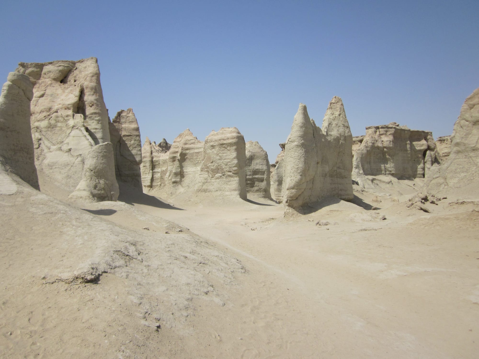
Pale eroded rock pinnacles and gullies rising from bare sandy ground under a clear blue sky

Shiraz & the South, Iran

Qeshm

The eroded pillars of Stars Valley on Qeshm Island in the Persian Gulf. (Petr Adam Dohnálek / Wikimedia Commons · CC BY-SA 3.0 cz)

The largest island in the Persian Gulf, lying close to the Iranian coast near the Strait of Hormuz and reached by ferry from Bandar Abbas. Salt caves, eroded canyons, mangrove creeks and wind-towered villages fill a long, narrow island that is also a free-trade zone. This page is written to explain the island, not to encourage travel.

Neighbourhoods

  • Qeshm town
    • First-time visitors
    • Close to public transport
    • Shopping

    The island's main town at the eastern tip, where the ferries dock and the free-trade zone's offices, hotels and shopping centres are concentrated. It is a working port rather than a resort, with a fish market, seafront road and the departure point for most island tours.

    Open in Maps
  • Dargahan
    • Markets
    • Local life

    The island's second town, on the north coast west of Qeshm town, known across the region for its large duty-free market, which draws shoppers over on the ferry for the day.

    Open in Maps
  • Laft
    • Historic district
    • Photography

    An old port village on the northern shore whose houses cluster under a forest of wind towers above a tidal creek full of wooden boats. Water for the village has long come from a field of hand-dug wells behind it.

    Open in Maps
  • The southern coast
    • Beaches
    • Quiet and residential
    • Wildlife

    A string of fishing villages along the Gulf shore with open beaches, boatyards and sea-turtle nesting sands. Development is thin here, and homestays in village houses are the usual way to stay.

    Open in Maps
  • The western end
    • Quiet and residential
    • Landscapes

    The far end of the island beyond the salt dome, dry and almost empty, with scattered villages, a long history as an anchorage and views across to the mainland mountains.

    Open in Maps

Things to do

Geopark landscapes

  • Stars Valleyattraction

    A maze of pillars and gullies eroded out of soft sedimentary rock north of the village of Berkeh-ye Khalaf, named in local legend for a fallen star.

    Open in Maps
  • Namakdan Caveattraction

    At 6.6 kilometres, one of the longest known salt caves in the world, running into the Namakdan salt dome at the south-western end of the island.

    Open in Maps
  • Qeshm Island Geoparkpark

    The UNESCO Global Geopark covering much of the island's geology, the framework under which its canyons, caves and coasts are managed.

    Open in Maps

Coast, mangroves and villages

  • Hara forestspark

    Mangrove creeks in the channel between the island and the mainland, a protected wetland and an important site for migratory birds, visited by small boat at high tide.

    Open in Maps
  • Laftneighborhood

    A historic port village of wind-towered houses above a tidal creek, one of the main centres where the Gulf's wooden lenj boats have long been built, with a field of 366 rainwater wells dug behind it.

    Open in Maps
  • Hengam Islandattraction

    A small island off the southern coast of Qeshm, reached by boat from the villages on that shore.

    Open in Maps

Short trips by boat

  • Hormuz Islandattraction

    The red-earth island east of Qeshm, famous for its coloured soils and mineral hills and for the remains of a Portuguese fortress at its port.

    Open in Maps
  • Bandar Abbasattraction

    The mainland port opposite the island, the regional capital and the place most journeys to Qeshm begin, with a long seafront bazaar.

    Open in Maps

Seasonal events

  • Nowruzlate March

    The Persian new year brings Iranian holidaymakers to the island at the end of the cool season, filling the ferries and the guesthouses.

  • Ramadanvaries with the lunar calendar

    The fasting month reshapes the day; eating and drinking in public stop in daylight and life moves to the evening.

  • Turtle nesting seasonspring

    Hawksbill turtles nest on beaches on the southern coast, where the hatching ground at Shib Deraz is watched and protected.

Eat and drink

Long-standing places and food districts in Qeshm. Hours, ratings and directions come from your maps app, always current.

Island food

  • Fish restaurants of Qeshm townneighborhood

    Grilled and fried Gulf fish with turmeric, garlic and lime, shrimp with spiced rice, and ghalyeh mahi, the sour tamarind fish stew of the south.

    Open in Maps
  • The fish marketmarket

    The morning catch is sold at the waterfront — mackerel, snapper, shrimp and cuttlefish — along with dried and salted fish for the store cupboard.

    Open in Maps
  • Dargahan marketmarket

    The island's big duty-free bazaar, where food stalls sell dates, spice mixes, tamarind, dried limes and imported goods alongside the shopping.

    Open in Maps

Experience Qeshm

History

Qeshm's history is the history of the strait it guards. Its position at the mouth of the Gulf drew invaders from the Elamites to the Umayyads and Abbasids, and through the Islamic centuries it lay on the sea route between Basra, India and East Africa, supplying water, salt and boats to the ports that controlled the trade. When the kingdom of Hormuz dominated the mouth of the Gulf, Qeshm was its larder and its water supply.

The Portuguese came in the sixteenth century, taking Hormuz and building a fort on Qeshm to hold the channel. In 1622 a combined force of Safavid troops under Shah Abbas and ships of the English East India Company drove them out, an episode that shifted Gulf trade to the mainland port that became Bandar Abbas. British naval power dominated the Gulf through the nineteenth century, and the island was occupied at times during that period; its people lived from fishing, pearling, salt and boat building, and from the long-distance dhow trade to Arabia, India and Zanzibar.

Modern Qeshm was shaped by two decisions: the establishment of a free-trade zone on the island around 1990, which brought duty-free markets, an airport, new roads and a jump in population, and the protection of its geology, which led to the island's canyons, caves and coasts being recognised as a UNESCO Global Geopark and opened a modest tourism economy based on landscape. Gas and oil installations along the Gulf coast and the shipping lanes of the strait remain the strategic backdrop to everything here.

Culture & Customs

Qeshm belongs to the Bandari world of the southern Iranian coast, which has as much in common with the Arabian shore and the Indian Ocean as with the Iranian plateau. Most islanders are Sunni Muslims, a minority within Iran, and speak a southern dialect alongside Persian; Arabic and Balochi are heard as well. The music is drum-led and fast, played on the large dohol drum, the neyanban bagpipe and hand percussion, and is closely tied to weddings and celebrations.

Dress is distinctive. Women on the island have long worn bright, loose clothing and, among older generations, the boregheh, a stiff embroidered mask-like face covering unique to this coast that visitors are asked not to photograph without permission. The island's other signature craft is boat building: the wooden lenj, built by eye without plans in yards at Laft and other creeks, carried the Gulf's trade for centuries, and the knowledge behind it is recognised by UNESCO as intangible cultural heritage.

The sea sets the social calendar — fishing, tides, the timing of boats to the mainland — and hospitality is taken seriously, with homestays in village houses now a normal way for Iranian travellers to visit. Older coastal traditions survive quietly, including healing ceremonies known as zar that arrived with the Indian Ocean trade. Village life is conservative and unhurried, and the island's free-zone towns, with their malls and traffic, feel like a separate country from the fishing settlements twenty minutes away.

Daily Life

Around 120,000 people live on the island, most of them in Qeshm town at the eastern tip and in Dargahan, with the rest in several dozen fishing and farming villages strung along the two coasts. The free-trade zone is the biggest employer in the towns: markets, warehousing, port work, construction and administration, along with the shipyards and the industrial installations on the coast. Fishing, shrimping and boat building support the villages, and a small tourism economy of drivers, guides, boatmen and homestays has grown up around the geopark.

Water and heat govern everything. The island has little fresh groundwater; wells cut into rock, cisterns that catch winter rain and, now, desalination and a pipeline from the mainland supply the towns, and gardens are small and walled. From May to September outdoor work stops in the middle of the day, and the towns come alive after dark.

The island has grown quickly, and the results are visible: new apartment blocks and shopping centres near Qeshm town, roads pushed into the interior, and villages losing young people to the towns or to the mainland. The national economic crisis, with its inflation and collapsed currency, is felt in the price of imported goods and of fuel for boats, while the strait's strategic importance means naval and security matters are part of ordinary life here in a way they are not elsewhere in Iran.

Food

Qeshm eats from the sea. Fish — mackerel, king fish, snapper, grouper — is grilled over charcoal or fried after a rub of turmeric, garlic, lime and hot pepper, and shrimp, crab and cuttlefish appear in season. The dish that defines the coast is ghalyeh mahi, a thick, dark stew of fish with tamarind, fresh coriander, garlic and plenty of chilli, eaten with rice; made with shrimp it is ghalyeh meygu. Dried and salted fish, hung in the sun, is a store-cupboard staple and appears in stews when the boats cannot go out.

Southern Iranian cooking is hotter and more sour than the food of the plateau, and closer to the Gulf's other shores. Rice is often cooked with dill, broad beans or turmeric; flatbread comes thin and blistered from a clay oven, and tomshi and other local breads are made at home. Samosas and falafel, brought over by Indian Ocean and Arab trade, are sold as evening street food, and dates, tamarind, dried limes and spice mixes fill the markets, with much of the produce coming over from the mainland groves.

Drinks are tea, drunk strong and dark through the day, doogh, which is salted yoghurt thinned with water, and fresh fruit juices; alcohol is illegal throughout Iran. On hot evenings families buy ice cream and faloodeh, the frozen starch noodles in rose syrup that are a national sweet, and eat them on the seafront.

Planning tools

Budget

Qeshm is cheaper than Kish, with village homestays and simple guesthouses alongside a few resort hotels near the main town. The real cost is transport: the island is long and public transport is thin, so a car with driver for a day of canyons, caves and mangroves is the usual arrangement, and boat trips are extra. Cash is essential.

Daily Budget Midrange
USD 50–95 (hotel in Qeshm town, restaurants, a driver for the island and a boat trip)
Daily Budget Shoestring
USD 20–35 (homestay or simple guesthouse, fish restaurants and market food, shared taxis and the ferry)

Bring cash from Bandar Abbas or Shiraz, as exchange on the island is limited, and agree the price of a driver or a boat before setting out.

Best Time to Visit

November to March, when days are warm and dry at around 20–25°C and the sea is calm enough for boat trips; this is also when turtles nest and migratory birds use the mangroves. From May to September heat above 40°C combines with heavy humidity and the island is punishing. That is the ordinary calendar: since 28 February 2026 Iran has been at war with the United States and Israel, and there is at present no good time to go.

Suggested Number of Days

The island is about 135 kilometres long and its landscapes are far apart, so two or three days is the usual length of stay. Adding the neighbouring islands and the mainland port takes it to four or five; ferry times and the weather change the plan more than anything else.

First Visit
2–3 days
With Surroundings
4–5 days

Transportation

Qeshm is large and its sights are scattered, and there is little public transport beyond shared taxis and minibuses between the main towns. Most visitors hire a local driver for the day or rent a car; a single road runs along the north coast between Qeshm town, Dargahan and Laft, with side roads south to the canyons and the coast. Boats go from the harbours to the mangroves and the nearby islands. That is the peacetime picture: the war that began in February 2026 has disrupted aviation and shipping across the region, and what is running has changed repeatedly.

Hire a local driver, since the sights are spread out and signposting is limited, and take boats early in the day in summer. Check what is running before relying on any route.

Airport & Station Connections

Most people arrive by sea from Bandar Abbas on the mainland: passenger boats take roughly half an hour to forty minutes to Qeshm town, and a car ferry runs to the island as well. Qeshm International Airport, near the main town, is linked by air to Tehran and to the United Arab Emirates in normal times. Crossings depend on the weather and the state of the Gulf.

Walkability

Qeshm town and the villages are small enough to walk around, and Laft is best seen on foot, its lanes climbing between wind towers in half an hour or so. The island itself cannot be walked: distances between the canyons, caves and coasts run to tens of kilometres of open desert road with no shade or water, and even in the cool months walking outside the settlements needs preparation.

Safety

Since 28 February 2026 Iran has been at war with the United States and Israel, and this coast has been at the centre of it: Iran blocked the Strait of Hormuz in March 2026 and later claimed sovereignty over it, and commercial shipping in the Gulf has repeatedly been attacked. The strait beside the island is a heavily militarised waterway, and naval and port installations are strictly off limits. Street crime is very low; the ordinary dangers are heat, dehydration, unmarked ground in the salt caves and canyons, and strong currents at sea.

Several governments strongly advise against travel to Iran. Never photograph ports, ships or military sites, carry water and go with a local guide in the caves and canyons, and avoid the island in high summer. Check current official travel advice before travelling.

Climate

Hot desert climate with high humidity from the sea. Rain is scarce and falls mainly between December and March; winter is dry, sunny and comfortable, and summer is long, extremely hot and sticky.

Summer
very hot and humid, with highs above 40°C and nights near 30°C
Winter
warm and dry, generally 20–25°C by day and cooler at night

Local Customs

A headscarf and loose clothing covering the arms and legs are compulsory for women in public, and swimming is done in the separated, enclosed beach areas. Most islanders are Sunni Muslims, unlike most of Iran, and village life is conservative: modest dress matters, and permission should be asked before photographing people, particularly older women who wear the stiff embroidered face covering of this coast. Homestays are common, and hosts press food and tea on guests.

Ask before taking photographs in the villages, keep cameras away from ports, boats and the strait, and remember that alcohol is illegal throughout Iran.

Common Payment Methods

The currency is the Iranian rial, with prices quoted in toman, worth ten rials. Foreign bank and credit cards do not work anywhere in Iran because of sanctions, and money cannot be withdrawn inside the country, so visitors bring euros or US dollars in cash. Exchange on the island is limited, so changing money in Bandar Abbas or Shiraz first is sensible, and small notes are needed for boats, taxis and homestays.