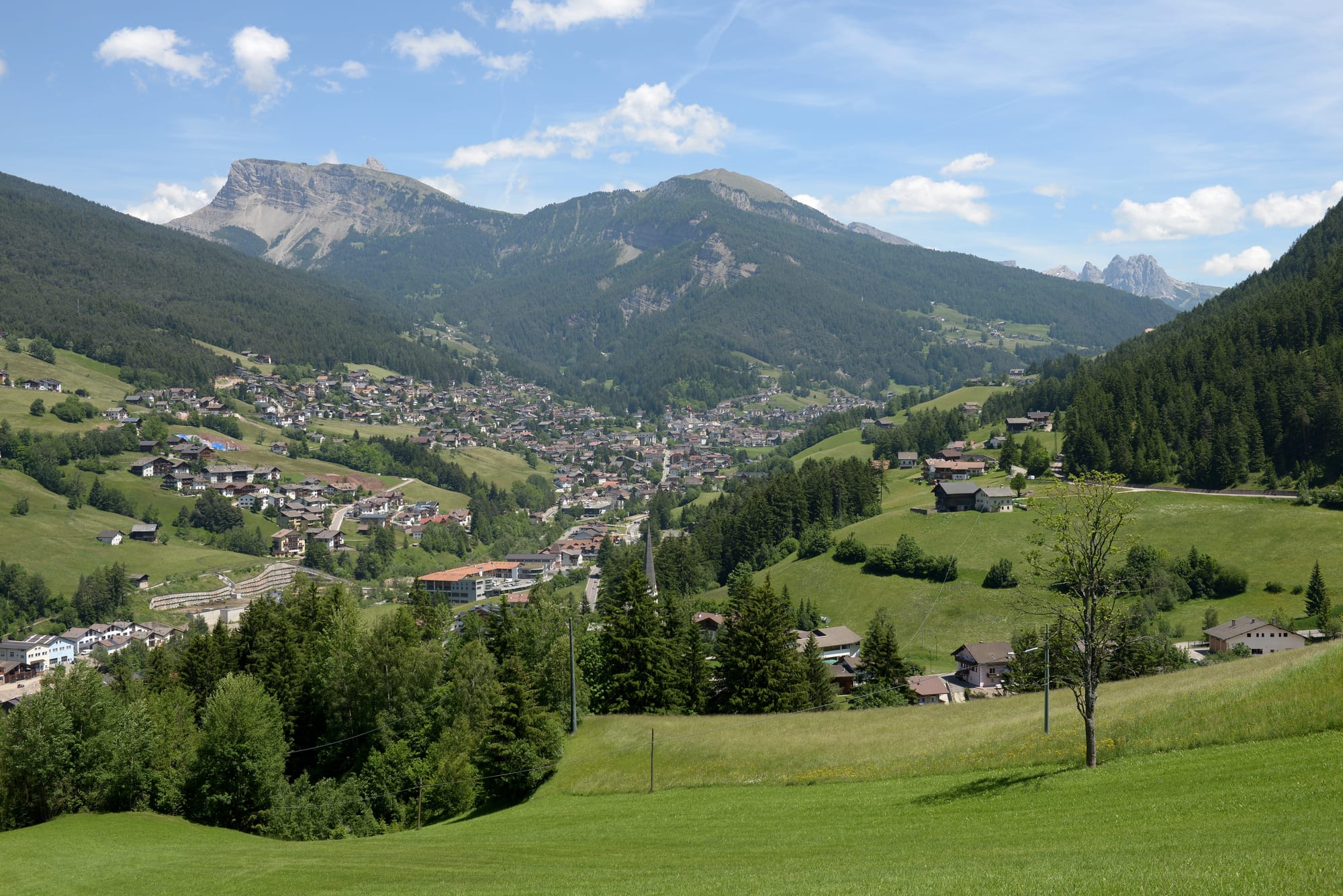
The houses of Ortisei spread along a green valley floor below forested slopes and grey limestone peaks under a blue sky

Trentino-Alto Adige / South Tyrol, Italy

Ortisei

Ortisei in the Val Gardena, seen from the Pas de Pinëi. (Wolfgang Moroder / Wikimedia Commons · CC BY-SA 3.0)

The main town of the Val Gardena in the Dolomites of South Tyrol, known in Ladin as Urtijëi and in German as St. Ulrich in Gröden. For more than two centuries it was an international centre of woodcarving; today a mostly Ladin-speaking resort of about 4,700 people lives from skiing, summer hiking and carving, with lifts climbing to Seceda and the Seiser Alm.

Neighbourhoods

  • Town centre and Strada Rezia
    • First-time visitors
    • Best for food
    • Close to public transport

    The compact centre on the valley floor around the parish church and the square of the church of St Antony. Strada Rezia, the main street, holds many of the town's restaurants, bars and cafés, the Cësa di Ladins with the valley museum, and the escalator tunnel up to the Seceda lift.

    Open in Maps
  • The northern slopes below Raschötz
    • Quiet and residential
    • Hiking access

    The town climbs from the valley floor towards the foothills of the Raschötz ridge, with houses and guesthouses scattered over meadows. The funicular to the Raschötz plateau and the lift to Seceda start on this side, and footpaths lead out of town into the Puez-Geisler Nature Park.

    Open in Maps
  • The south bank villages
    • Quiet and residential
    • Close to the Seiser Alm

    Across the Derjon stream, the Ladin-speaking villages of Pufels, Runggaditsch and Überwasser belong to the municipality of Kastelruth but look to the Val Gardena in daily life. They sit below the Puflatsch plateau and the Seiser Alm, reached by cable car from Ortisei.

    Open in Maps

Things to do

In the town

  • Museum Gherdëinamuseum

    The valley museum, opened in 1960 in the Cësa di Ladins, with woodcarving from the last three centuries, old wooden toys, paintings by local artists, fossils and archaeological finds.

    Open in Maps
  • Parish Church of St Ulrichlandmark

    A late 18th-century church, neoclassical with baroque elements, which displays a large collection of statues carved by artists of the valley over the last two centuries.

    Open in Maps
  • Church of St Jacoblandmark

    The oldest church in the Val Gardena, reached by a steep path through the woods, remodelled in Late Gothic style in the 17th century and keeping frescoes from the second half of the 15th.

    Open in Maps
  • Val Gardena Railway trailtrail

    The route of the narrow-gauge railway that served the valley from 1916 to 1960, built largely by Russian prisoners of war; one of its locomotives is preserved beside the trail in Ortisei.

    Open in Maps

Lifts, peaks and meadows

  • Secedaviewpoint

    A 2,519-metre summit of the Odles Group, the highest point of the municipality, reached by lift from the town, with views of the jagged Fermeda peaks.

    Open in Maps
  • Seiser Almpark

    Europe's largest high-elevation Alpine meadow, a plateau of hay fields and pastures reached by cable car from Ortisei, used for hiking in summer and skiing in winter.

    Open in Maps
  • Puez-Geisler Nature Parkpark

    The nature reserve that protects much of the Raschötz ridge and the Odles peaks above the town, crossed by marked footpaths.

    Open in Maps

Further up the valley

  • Santa Cristina Gherdëinaattraction

    The next Ladin village up the Val Gardena, the middle of the valley's three municipalities.

    Open in Maps
  • Sëlvaattraction

    The third of the valley's municipalities, one of the starting points of the Sella Ronda ski tour, and home to the Pranives Ice Stadium where HC Gherdëina plays.

    Open in Maps
  • Saslongattraction

    The World Cup downhill course on the slopes of the Sassolungo, one of the classic men's downhills, known for its 'Camel Humps' jumps.

    Open in Maps
  • Sassolungoviewpoint

    The 3,181-metre peak that stands over the Val Gardena; its Ladin, Italian and German names all mean 'long rock'.

    Open in Maps

Seasonal events

  • Saslong Classicwinter

    The men's World Cup downhill on the Saslong course, held almost every year since 1969 and paired with a Super-G.

  • Sellaronda Skimarathonwinter

    A ski-touring race around the whole Sella massif, covering 42 km of mountain trails through the four Ladin valleys.

Eat and drink

Long-standing places and food districts in Ortisei. Hours, ratings and directions come from your maps app, always current.

Ortisei classics

  • Restaurants on Strada Rezianeighborhood

    The main street, lined with many of the town's restaurants, bars and cafés serving the cooking of South Tyrol and the wider Italian repertoire.

    Open in Maps
  • South Tyrolean dumplings and speckrestaurant

    Knödel dumplings, Schlutzkrapfen pasta and lightly smoked Speck Alto Adige ham are the staples of local menus.

    Open in Maps
  • Kaiserschmarrnrestaurant

    The lightly sweetened shredded pancake named after Emperor Franz Joseph I, served as a dessert or a light lunch in town and up at the lifts.

    Open in Maps

Experience Ortisei

History

The town's names record its past. Urtijëi and its Italian form Ortisei come from a farmstead called Ortiseyt, documented as early as the 13th century, a name built from the Latin urtica — the "place of nettles". The German name, St. Ulrich, comes from the parish's patron saint, a reminder of the medieval possessions of the church of Augsburg in the Eisack valley and Gröden. The first written record of the Val Gardena itself dates from around the year 1000.

From the 17th century a large part of the population took up woodcarving — sacred sculpture, altars and wooden toys — and for more than two centuries the town was regarded as an international centre of the craft. A major road down to the railway brought rapid growth from 1860 to 1914, and the carvers flourished. Mountaineers such as Paul Grohmann discovered the peaks above, English visitors followed and then others from Austria-Hungary and Germany, and Emil Terschak, who lived in the town in the 1890s, gave winter tourism its push. Sacred carving peaked around 1900 at the art school founded by Ferdinand Demetz.

During the First World War, Russian prisoners of war built the Val Gardena Railway, which linked the valley to Klausen until 1960. The first cable car of the valley, to the Seiser Alm, opened here in 1935, and the town hosted the Alpine World Ski Championships in 1970. The Second Vatican Council brought a sharp decline in demand for sacred carving, and since the 1960s mainly small, largely machine-carved figures have found buyers abroad.

Culture & Customs

Ortisei is a majority Ladin-speaking municipality, and the Val Gardena is one of five valleys where most people speak Ladin, a Romance language related to Romansh and Friulian; the local form is called Gherdëina. The Cësa di Ladins, which houses the valley museum and a library of Ladin language and culture, is the seat of the association that works to keep the language alive, and the local schools belong to the Ladin language group.

Carving remains the town's signature. In the 18th century the valley produced statuettes of beggars and figures of the four seasons alongside religious work; by the 19th century toy-making was so widespread that the writer Amelia Edwards called Urtijëi the "capital of Toyland", and its peg wooden dolls were sold across Europe and America. Statues and altars carved here were shipped to Catholic churches around the world. The town has the valley's only secondary schools, among them an art high school and a vocational school for arts and crafts. The Moroder family has produced generations of sculptors and painters, and the film-maker and mountaineer Luis Trenker is among the town's best-known figures.

Winter sport runs deep: the Saslong downhill brings the World Cup to the valley most winters, the Olympic medallist skier Isolde Kostner and the figure skater Carolina Kostner, who lives in the town, are local names, and the valley's ice hockey club, HC Gherdëina, was originally based here.

Daily Life

About 4,700 people live in the municipality, which covers only the northern side of the valley floor, at around 1,170 to 1,350 metres, and the slopes rising behind it. It is the largest of the valley's three municipalities, and its secondary schools serve the whole Val Gardena.

The economy rests on winter skiing, summer hiking and woodcarving. Lifts, hotels, guesthouses, ski schools and restaurants employ much of the town in season, while carvers' workshops and galleries keep the old craft going. The valley's fields were traditionally sown with barley, rye, potatoes, flax and buckwheat, and most of the steep slopes around are pine forest.

The year follows the seasons. From December the streets fill with skiers heading for the lifts and the circuits around the Sella group; in summer the crowds are walkers bound for Seceda and the Seiser Alm. Between the seasons, in spring and late autumn, many lifts close and the town returns to its residents. Daily conversation moves easily between Ladin, German and Italian.

Food

Ortisei eats as the rest of South Tyrol does, where Tyrolean and Italian kitchens meet. Speck Alto Adige, a dry-cured and lightly smoked ham with protected status, appears on boards and in dumplings. Knödel are boiled dumplings of the Central European kind, and Schlutzkrapfen are semicircular filled pasta made from white and rye flour, eggs and oil, typically stuffed with cheese, spinach or mushrooms.

Sweets lean towards Austria. Kaiserschmarrn, a lightly sweetened, shredded pancake named after Emperor Franz Joseph I, who was fond of it, is eaten as a dessert or a light lunch, and apple strudel is everywhere in a land of apple orchards. The restaurants, cafés and bars of the town are concentrated along Strada Rezia, the main street, and there is a restaurant at the top of the Seiser Alm cable car.

Drinks come from the wider region: South Tyrolean white wines and reds from the Lagrein and Schiava grapes, and grappa.

Planning tools

Budget

Ortisei is one of the pricier resorts of South Tyrol, above all in the ski season and in August, when rooms and lift passes are at their most expensive. Spring and late autumn are cheaper but many lifts and some hotels close. Half-board is common, and lift tickets are the other large cost.

Daily Budget Midrange
USD 180–350 (half-board hotel, a cable car or ski pass, restaurant dinners)
Daily Budget Shoestring
USD 90–140 (guesthouse or farm-stay room, dumplings and simple lunches, regional buses)

A MobilCard covers all public transport in South Tyrol for three or seven days, and the Museumobil version adds entry to around 80 museums.

Best Time to Visit

June to September is hiking season, when the lifts to Seceda and the Seiser Alm run and the meadows are green. December to April is ski season, with the town on the Sella Ronda and Dolomiti Superski circuits. Between seasons the town is quiet and many lifts stop.

Suggested Number of Days

Two or three days give a first look at the town and its nearest lifts and meadows. Hikers and skiers usually stay a week, since the town is a base for the whole valley and the ski circuits; weather in the mountains can also cost a day or two.

First Visit
2–3 days
With Surroundings
5–7 days

Transportation

The town is easily walked, and marked footpaths link it to the neighbouring villages. Lifts do much of the climbing: a cable car to the Seiser Alm, a lift to Seceda reached through an escalator tunnel from the centre, and a funicular to the Raschötz plateau. Regional buses run through the valley, and the MobilCard is valid on all of them.

Evening buses from Bolzano may stop short of the valley, so check the last departure before setting out.

Airport & Station Connections

There is no railway in the valley since the narrow-gauge line closed in 1960. Travellers take the train along the Brenner line to Ponte Gardena (Waidbruck) and the bus up the valley from outside the station; direct buses also run from Bolzano, Brixen and Klausen. Drivers leave the A22 motorway at Klausen. The nearest large airports are Verona, Innsbruck and Munich.

Walkability

The centre is small and easy to cover on foot, though the town climbs steeply up the northern slope; the escalators and moving walkways from the centre to the Seceda lift save the steepest part. Paths lead out of town in every direction, and in winter streets and paths can be icy.

Safety

Italy is generally safe, with low levels of violent crime against visitors. In Ortisei the real risks are mountain ones: sudden storms and lightning in summer, rockfall, exposed climbing routes and avalanches away from the marked pistes in winter.

Check the weather and avalanche bulletins before heading into the mountains, start long walks early to avoid afternoon storms, and stay on marked pistes and paths. Check current official travel advice before travelling.

Climate

An Alpine climate. The town lies at about 1,170 to 1,350 metres on the valley floor, cooler than the Adige valley below, with snowy winters, and the peaks above have long, cold winters and short, mild summers.

Summer
mild — in nearby Sëlva (measured at Plan, 1,594 m) summer days average 18–21°C and nights fall to 6–9°C
Winter
cold — in nearby Sëlva winter days average 0–2°C and nights fall to between −6 and −9°C

Local Customs

Ortisei is trilingual: most residents speak Ladin among themselves, and German and Italian are also in daily use, so place names appear in all three. Woodcarving is part of local identity, and carvers' workshops and galleries are common. Tips are not customary in Italy; restaurants often charge a cover charge, the coperto, and a euro or two is welcome for good service.

A greeting of 'Grüß Gott' or 'Buongiorno' on entering shops and public places is customary; dress modestly in the churches and keep quiet during services.

Common Payment Methods

The currency is the euro. Cards are widely accepted in shops, hotels and at the lift stations, and the town has ATMs; some mountain huts and small businesses prefer cash.